

INDEX
My Trail?
Metamora To Yellow Bank
By R. V. Morris
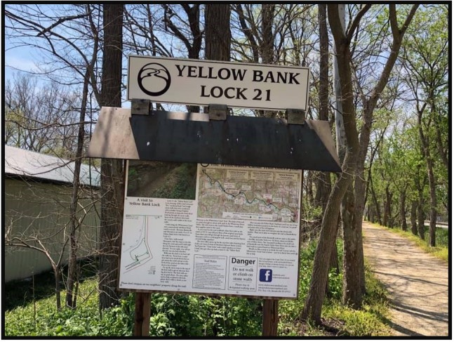
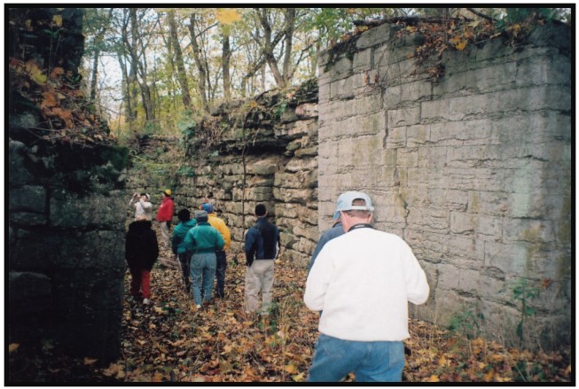
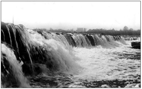
The walk from Metamora to the Yellow Bank trailhead provides sweeping vistas across the stunning Whitewater valley. As I cross the most beautiful land in Indiana I stroll past the double locks which stand like sentinels against time. I always stop to examine the culvert that looks like it holds together on faith rather than structural integrity. Will this be the last time I will see it standing? The gem of the trip is the huge lock at Yellow Bank Creek. To stand at the base of the lock as it towers over me always provides a perspective of how massive this building project really was, and then I read the sign again that states that even now I am standing on four feet of fill at the base of the lock for a total of twelve feet of lift. As cool as the lock is I am always sad at the site.
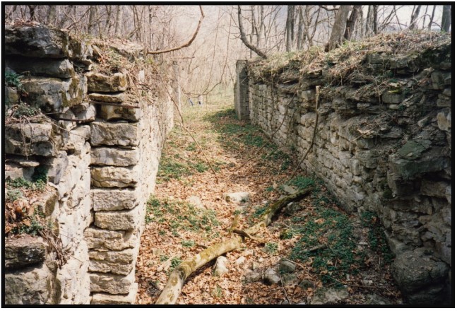
I know that the Yellow Banks double stone culvert is gone from the site. Once when searching in the woods for it, I found three stones stacked on top of each other that had obviously been forgotten in the frenzy to destroy it. I have seen the photo of it reaching across the stream and valley standing strong against time and the elements. It is hard to imagine how big it must have been. I wonder what it would take not to rebuild it, but to memorialize it with chrome tub or a similar artistic treatment that would replicate its dimensions, its barrel vaults, wing walls, and the outline of its prism. As a large interactive public sculpture, it would provide yet another way to understand and experience the scope of the canal.

A memorial to the missing Yellow Banks double culvert would also help add context to the Yellow Bank Creek site. There was a reason for the large lock; the canal could not be on the same level as Yellow Bank Creek. If it were on the same level the water of the canal would simply flow into the neighboring Whitewater River leaving the land between the up and downstream locks dry with boats stuck in the mud of the canal bottom. The Yellow Bank double culvert carried the canal over Yellow Bank Creek. Once it got to the other side and enough away from the potential flood waters of the creek the builders of the canal wanted to drop the level of the canal as soon as possible. Building an elevated canal was expensive compared to a canal at the level of the land, and the Yellow Bank lock had this important job of dropping the level of the canal as rapidly as possible after the double culvert.
As an interactive memorial at Yellow Bank a double culvert remembrance combines elements of modern sculpture with visitor interaction to provide historical understanding. I am proud to be a part of the Canal Society of Indiana, a group that has done so much to document the history of the canal in our state. If you want to learn more about the double culvert at Yellow Bank or the Canal Society of Indiana please explore our website.
“Trails – Rails: Canal Connections”
Symposium Recap
By Sue Simerman, Secretary

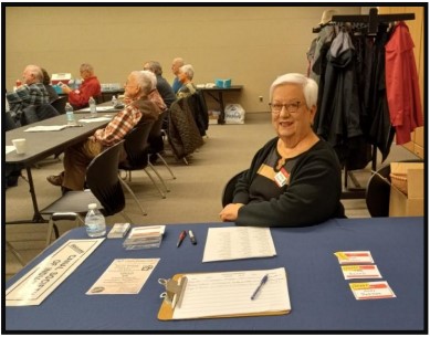
The Canal Society of Indiana held a free “Trails-Rails: Canal Connections” Symposium Saturday, March 25, 2023 at the Allen County Public Library, 900 Library Plaza, Ft. Wayne, Indiana. This was followed by the society’s annual meeting and election of directors. 59 attendees, 13 directors, 8 new memberships*
CSI directors and members in attendance were: Carl & Barbara Bauer, Craig Berndt, Terry Bodine, Susan Braun, Tom & Linda Castaldi, James Crouse, Randy Elliott, Jerett Godeke, Lowell & Margaret Griffin, J.K. Porter Gresham, Sue Jesse, Jeff Koehler, Melinda Krick, Dan McCain, Phyllis Mattheis, Dennis & Kari Meinert, Ron Morris, Mike Morthorst, Jane Nice, Angie O’Neill, Beth Ricketts, Ted Sadler, Bob & Carolyn Schmidt, Henry Schmitt, Steve & Sue Simerman, Melissa Smith, Neil Sowards, Mike Tetrault, Steve & Sharon Williams, and Virginia Zimmerman attendee Russ Voorhees and his wife Sandy joined later
Others attending: Mike, Kim & Beth Avila, Anne Braun, Steve Bryan, Becky Cummings, John Gercher, Michael Gillman, Dave & Becky Good, Randy Harter, Bill Lapcheska, Craig Leonard, Alberta McConnell, Becky Osbun, Howard Pletcher, Stan & Barb Searing, Brian Stirm, Jon VanSant, Willian Verduce
We were greeted with name tags and a bag of helpful information including canal exhibits to visit and the map of the Canal Systems of Ohio and Indiana.
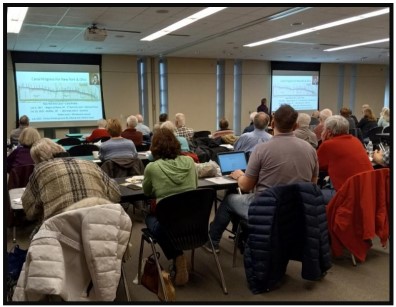
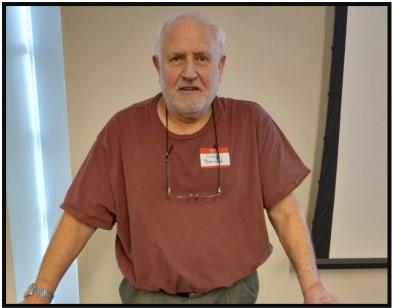
President Bob Schmidt began with a power point presentation which told of the time when the glaciers began to melt. The Wisconsin Glacier retracted and left the northeastern area of Indiana with three rivers and The Black Swamp. The rivers in Indiana tend to flow from NE to SW. He explained a timeline of the French and the British and their desire to gain more of the lands in North America. The Spanish were involved also in setting up in Florida and on the Mississippi River.
He talked about the Erie Canal. It was built by private investment, officially opened in 1825 and was very successful. It was 363 miles from Lake Erie to the Hudson River. It brought settlers and goods west. Governor DeWitt Clinton of New York came to Ohio to break ground in 1825 for the Ohio and Erie Canal. This canal connected Lake Erie at Cleveland to the Ohio River. Bob followed a timeline including the use of flat boats and then steamboats on the Ohio River. He went on to mention federal land grants, land speculators, canal engineers and workers. Jesse Lynch Williams became the Chief Engineer for the Wabash and Erie Canal. Bob said he could only touch on the basics and we should go to the website to learn more about these men. Others were against building canals and desired to wait for the railroads to be built. Bob finished with “Thoughts for Today.”
We broke for our brown bag lunch. The society provided beverages and board member Margaret Griffin, with the help of Sue Jesse, gave us an excellent selection of cookies.
After lunch we had numbers drawn to win books that pertained to Indiana and/or canals. I got a history of the Indianapolis Central Canal. The books were donated by the family of Jerry and Mary Ann Getty. They both had lived in Fort Wayne and passed away this past year. They were very active members with the Canal Society of Indiana and other historical societies.
Our next speaker was Craig Berndt, CSI member from Fort Wayne. He spoke about the interurbans of Indiana and especially “The Canal Route,” which operated 1902-1938 and had most of its track laid on the Wabash and Erie Canal towpath. Fort Wayne had five lines that operated out of the city. They went to Garret, Decatur, Bluffton, Lafayette and Van Wert, Ohio.
At first the cars were named but were later changed to a numbering system. At first they were built of wood with steel undercarriages. When they converted to steel cars the wooden cars became work cars.
In Fort Wayne the passenger depot was at the corner of Harrison and Pearl Streets. The freight depot was on Pearl St. Today interurban track abutments can be seen at Aboite Creek (Allen County) on Redding Road near U.S. 24 beside the abutments of the Wabash and Erie Canal Aqueduct.
Craig and several others have done extensive research to find substations, river crossings and photos of interurban cars and buildings related to the history of Indiana’s interurbans. Lagro in Huntington County has a substation with attached depot sitting beside the Wabash River that can be viewed today. It is close to the Ditton Lock, which is buried beneath the street. Craig said that substations were built about every 10 miles. The substation in southern Allen Co. at Hwy. 27 and Hoagland Rd. would be 10 miles south of Fort Wayne, because the history of Nine Mile Tavern/Restaurant says it is about nine miles south of downtown Fort Wayne and one mile north of this substation. It had been a stagecoach stop. It is said that the bar began in 1837. This interurban line goes to Decatur.
We appreciated the time and effort that was taken to accumulate all of this information. Another great presentation.
Bob returned to the podium and explained the mission of CSI, which included preservation of canal structures and encouraging restoration. We promote education with our website which includes our newsletter ‘The Tumble,’ which has bios, maps, tours, etc. We are placing signage along all of Indiana’s canals. Three new signs are being planned in Wayne county through memorial funds for Jerry Mattheis, who had been a long time CSI director. Ron Morris, director from Centerville, has secured the help of Fayette county to place 14 more canal signs.
Next was the election of the CSI board of directors. Two directors are stepping down, Terry Bodine and Cynthia Powers. We are adding Jerett Godeke of Antwerp, Ohio (Wabash and Erie Canal) and Candy Yurcak of Metamora (Whitewater Canal) to the electoral ballot. The following were elected for a three year term – Jerett Godeke, John Hillman, Phyllis Mattheis, Sue Simerman, and Preston Richardt. Candy Yurcak was elected to fill a vacated term of two years.
Several attendees went to the podium to share information. Jane Nice promoted a dinner/theater play which tells the story of the Reservoir War and the dynamiters near Antwerp, Ohio. It will take place April 14-15-16. It is a fund raiser
Henry Schmitt of Fountain County came forward to tell us of an essay contest for fourth graders. Through it 80 students learned about the Wabash and Erie Canal. He encouraged other counties to reach out to the kids to further the education of our canals. Fountain county also has a fund raiser to save their covered bridge and they have a goal of $400,000.
Bob thanked everyone for coming and encouraged those attending to become CSI members.
CSI directors finished the day with the election of officers:
- President – Bob Schmidt
- Vice President – Mike Morthorst
- Secretary – Sue Simerman
- Treasurer – Margaret Griffin
Below are the biographies of our new directors and new treasurer:
Jerett Godeke – Director

A lifelong resident of Antwerp, OH, Jerett W. Godeke is an Independent Scholar who received his master’s degree in History (and a certificate in Public History) from Bowling Green State University in 2022. Jerett’s primary research focus is local history in America’s Rust Belt region, particularly those pertaining to the region’s transportation history. Jerett’s interest in canal history is a relatively recent revelation, having come about due to the COVID-19 Pandemic derailing any reasonable ability to research Ohio’s electric interurban railways. As a result of this, Jerett instead chose to explore a topic from his hometown and has spent the last two and one-half years researching and writing the first book on Paulding County, Ohio’s ‘Reservoir War.’ On top of helping his local community become closer to its history, the work that went into this project has also aided communities like Redwood City, CA, to learn more about notable individuals in their history.
Jarett has expressed an interest in leading a Canal Society of Indiana tour along the Wabash & Erie Canal in Paulding County, Ohio. This will probably be held in the fall of 2024. Although the society toured the reservoir area twice before (October 1998 and April 2002) the last tour was over twenty-years ago and we have new members who have not been there.
Candy Yurcak – Director

In 1988 Candy Yurcak, a woodworker/furniture builder who was born and raised in Marion, Indiana, moved to Metamora with her two daughters. With a deep curiosity of the Whitewater Canal and its history she began to expand her knowledge of the canal.
Candy and others spearheaded the creation of the Whitewater Canal Scenic Byway to expand tourism. The Whitewater Canal Byway Association (WCBA) was formed in 2006 to develop and support the Whitewater Canal Scenic Byway. In order to raise funds and increase awareness for the project Candy walked the entire corridor from Hagerstown, Indiana to Lawrenceburg, Indiana five years in a row. In 2008 the Byway was designated a state byway and, two years later its three loop routes were added, the first of its kind in the United States. Today, this Byway traverses seven counties in two states.
Candy served as President of the WCBA from its inception in 2006 until 2015. In 2007, she initiated efforts to purchase the 33-acre Maclynn Campground in Metamora to serve as a central headquarters for the group. It was then purchased in 2010 and named the Whitewater Valley Gateway Park. It includes a conference center in the restored Brookville Depot, a Visitors Pavilion, the WCBA offices, and a 40-site full-hookup campground. Another existing building it targeted as a future museum site.
To promote the importance of scenic byways, Candy was commissioned to produce and film a movie, The WHY in the Road, which premiered at the IMAX Theater in Indianapolis during the National Historic Roads Conference in September of 2012. She produced another film, We Are Indiana, to celebrate Indiana’s Bicentennial in 2016.
In 2020, the Federal Highway Administration opened up a new round of national byway applications which Candy pursued. In 2021, the Whitewater Canal Scenic Byway was officially designated Indiana’s fourth National Scenic Byway. Candy continues to serve as a board member of the Whitewater Canal Byway Association. A tireless champion, she is working with utilities and numerous agencies to protect local landmarks from flooding along the Whitewater River, including Gateway Park’s Depot, the Duck Creek Aqueduct National Landmark, and historic Metamora.
Margaret Griffin – Treasurer
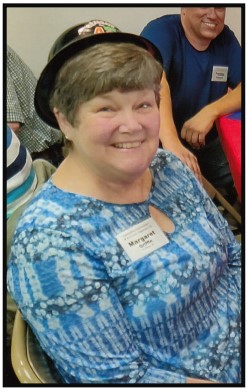
Margaret Griffin is a native Hoosier. She grew up in Angola, Indiana and lived in Huntington where she taught fifth grade for 25 years. Now retired, she and her husband, Lowell, live in Southwest Allen County near Fort Wayne. They have two grown daughters and five grandchildren who live in the Indianapolis area.
After retirement, she began volunteering at the Forks of the Wabash Historical Park in Huntington. She interprets in the Canal Room, presenting for school tours in the Spring and Fall. Margaret is the secretary of the Indiana Chapter of the Theodore Roosevelt Association and has written two books: The Amazing Bird Collection of Young Mr. Roosevelt about our 26th President’s boyhood; and Folks on the Home Front, about her grandparents during World War I. She is doing research for another nonfiction book about the Wabash and Erie Canal.
Schmidt’s Symposium Presentation Part 1
By Bob Schmidt, CSI President
Following our March 2023 Symposium, several people requested the details of my presentation. The program was unscripted and it is not available on our CSI website. For those who were unable to attend or those wanting a further review of that presentation, here is a summary of the major points.
My presentation, “The Canal Planners, Builders & Operators,” began with a review of transportation trends in the Midwest, from early French discovery through 19th century canal building. My conclusion was that all along this journey a few changes or delays, would have had a major impact on the ultimate development of our area and the young United States. The bottom line was that the Erie Canal and those canals that followed were critical to the development of the Midwest. Even the outcome of the American Civil War might have been different. Along the way I presented individual biographical sketches, which I hope you will investigate on our CSI website: indcanal.org.
The W&E Canal Planners Builders & Operators

The Wisconsin glacier retreated in northeast Indiana about 12-15,000 years ago and left us with both favorable and unfavorable landscape features. The glacial ridge or summit at Fort Wayne was well supplied with two sources of water: the St. Joseph and St. Mary’s Rivers, a necessity for future canal building. Unfortunately as the glacier retreated into the Lake Erie basin, it left a meandering Maumee River through the notorious Black Swamp. The meandering river was shallow and unsuitable for river navigation and the swamp was a definite obstacle to future canal building. The glacier also rearranged most of Indiana’s rivers to drain into a southwesterly direction and they were usually too shallow for future navigation. Only the Wabash and the Ohio Rivers were deep enough to support boats larger than early flatboats.
The Midwest was first occupied by native tribes, but in 1681 the French arrived in South Bend, Indiana, where Robert LaSalle met with native peoples at the Council Oak. The French were quite satisfied to just use the Great Lakes and our rivers to reach the Mississippi and travel down it to their key settlement at New Orleans. The British and their colonies along the eastern coast initially were not a threat, but as the British settlements grew, their appetite for western expansion also put pressure on the border beyond the Appalachians. When French plans expanded their reach and then when they attempted to occupy the forks of the Ohio River at Pittsburg, a conflict developed. Young George Washington, who delivered vacate messages to the French, ended up killing a French officer. This lead to the French and Indian War with the British Colonies and the Seven Years War in Europe. At the conclusion in 1762 / 63, France lost its territory in North America. Great Britain gained Canada and the land east of the Mississippi. Spain gained New Orleans and the Louisiana territory west of the Mississippi and forfeited Florida to Great Britain.

On the surface, this transfer of lands would appear to benefit and accelerate growth in the Ohio country, but unfortunately it did not. The native tribes, who had supported the French, were still quite a threat to western English settlement. King George issued the Proclamation of 1763 forbidding additional settlement beyond the Alleghenies. Colonists and land speculators on the East coast, such as Washington and Franklin, were now stymied. In addition, the English Parliament wanted the colonists to help pay for the past war with France and future protection against Indian attacks. A variety of taxes were levied but the most notorious was the Stamp Act. This united the American colonies in opposition to Parliament. These taxes culminated with the Townsend Acts and the Tea Act that was the final straw. The War for Independence that began in 1775 ended in 1783. The Treaty of Paris resulted in a Confederated Government in American gaining the area east of the Mississippi. Spain still retained New Orleans and the territory west of the Mississippi and regained the Florida territory from Great Britain.
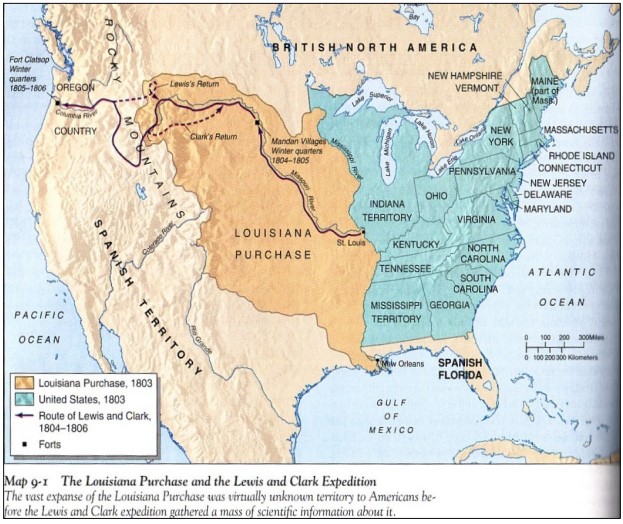
During all of these changes in land ownership, the flow of trade for those early settlers in the Midwest did not change. The rivers flowing to the southwest toward New Orleans still provided the primary transportation route. The Spanish were not favorably inclined to the new United States and at times shut down the port of New Orleans. There were attempts by some persons at the time to align these western areas with Spain rather than the U.S. When President Jefferson learned in 1800 of a secret treaty with Spain agreeing to return the Louisiana territory back to France, he sent U.S. ambassadors to France to deal with Napoleon. President Jefferson only wanted to purchase New Orleans and offered $5 million, but Napoleon surprised him with an offer to buy the whole territory for $15 million. In 1803 the U.S. acquired the whole Spanish/French territory west of the Mississippi. On December 20, 1803 a flag ceremony occurred in New Orleans, lowering the Spanish flag, raising the French flag, then lowering it and finally raising the U.S. flag. A similar ceremony was held in St. Louis on March 10, 1804. The port of New Orleans was now completely secure for the United States. Spain still retained Florida.
Despite these transfers of western territory, the flow of economic activity was still to the southwest to New Orleans. Most economic activity to the East was still minimal. For Ohio and Indiana there were 3 major paths of economic activity to follow, the Ohio River, the National Road and the Erie Canal. The Ohio River route to New Orleans was dominated by flat-boating and keel boats until 1811 when the first steamboat, the “New Orleans” traveled from Pittsburg to the Crescent City. This new steam technology now allowed for 2-way travel on the rivers. There was still a river barrier to circumvent at Louisville, where the Falls of the Ohio provided a drop of 26 feet in 2 ½ miles. Eventually in 1830 the Louisville & Portland Canal was opened allowing shipment of goods without a transfer at the Falls City.
Despite this navigational improvement, the main flow of goods continued from the Midwest to the South. Goods from New Orleans reached Indiana and Ohio but still only minimally to eastern markets. Goods could reach Pittsburg but there the goods had to be transshipped across the mountain via the inclined planes of the Alleghany Portage Railroad. This was a series of locations along the canal route with cables pulling canal boats over the mountain. This system at best was marginal and somewhat worked for passengers, but it really didn’t work for goods heading east and west.
The National Road – West & East
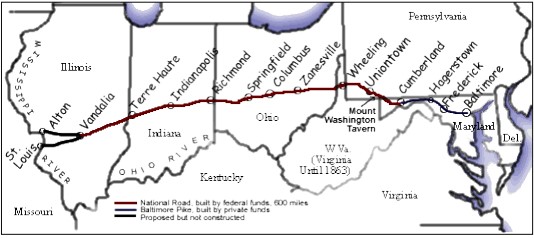
The second path of economic activity was the building of the National Road that was begun in 1811 at Cumberland, Maryland. This route was built with Federal funding but maintenance was soon turned over to the states. The route did provide access to the East, but most of the traffic was by cumbersome Conestoga wagons filled with settlers moving west. Moving goods east across the mountain barrier was still challenging. At Wheeling, West Virginia the National Road crossed the Ohio River by ferry until 1849. Goods coming upriver on the Ohio had to be unloaded and loaded onto overland wagons. The National Road was improved about as far as Indianapolis. The road finally did reach Vandalia, Illinois, but it was still mostly used by travelers heading west.
The Erie Canal – Opened 1825
The third pathway of transportation really opened the Midwest to economic activity both east and west. Competition between the states for a better route west had increased. Funding by the Federal Government was stymied, and New York was forced to proceed with a canal plan using their own finances. Without the push by Governor Dewitt Clinton and others the Erie Canal would not have been built. Skeptics were everywhere. The federal government would not fund the canal. Canal engineers were even non-existent. This planned project was delayed by the War of 1812. In 1817 construction finally began at Rome, N.Y., the summit. The canal initially faced several major problems: two separate summits and the Montezuma swamp. The final barrier was at the Niagara Escarpment, a 60 foot ridge of hard dolomite. This ridge is where the Niagara River flows over the falls. One Erie engineer, Nathan Roberts, was able to plan and execute a double series of 6 locks to raise and lower canal boats over this ridge. It was a wonder of the world at the time.
Even Lafayette visited this site in 1824 to observe the marvel of Yankee engineering. This final barrier to the Erie Canal could have delayed or stopped the whole project. Even during the building of the Erie Canal Governor Clinton was voted out of office and then reelected in 1825 just in time to complete and celebrate the canal opening. The whole Erie project could have been a failure. It was costly and lacked proven engineering from the start.
Governor Clinton was optimistic from the early days. By 1825 when the project was nearing completion, he traveled to Ohio. He realized that for the Erie Canal to be most successful, the grains and goods from the Midwest needed to be fed into his canal. On July 4, 1825 he traveled to Heath, Ohio at the Licking Summit to break ground for the Ohio & Erie Canal. Two weeks later he was at Middletown, Ohio for another groundbreaking for the Cincinnati – Dayton Canal. This was to be the first phase of the Miami & Erie Canal to Junction, Ohio that finally was completed in 1845, linking western Ohio to Toledo on Lake Erie.
Unfortunately, Gov. Clinton died in February 1828 at age 58 and did not live long enough to see the payoff of his canal project. Tolls from the canal traffic in a few years paid off its $7 million cost of construction. The Erie Canal was critical in opening economic ties between the west and the east coast. Ohio and Indiana’s canals followed and increased the bond with the East. The railroads in 1830 were just beginning to be developed. The economic development in the Midwest created cities and farms. By 1860 the railroads had followed the economic development created by the canals. The railroads created the final link between eastern and western markets. Without the strong economic ties to the east, there is a distinct possibility that the Midwest, because of the river linkage to the South, would have linked with the South by either joining the Confederacy or maybe even becoming a separate country. During the Civil War it was essential that the Mississippi River be under federal control, not just as a means to choke off the South, but also to open river traffic from the Midwest to New Orleans. Still today, 90% of the U.S. grain export is via New Orleans.

The Erie Canal provided an opportunity for the Midwest, but there were other difficulties and delays that occurred delaying canal construction. These difficulties impacted economic development. We will discuss these delays in a future issue of The Tumble.
Canal Notes
9 – Col Vigus’ Shovel
By Tom Castaldi

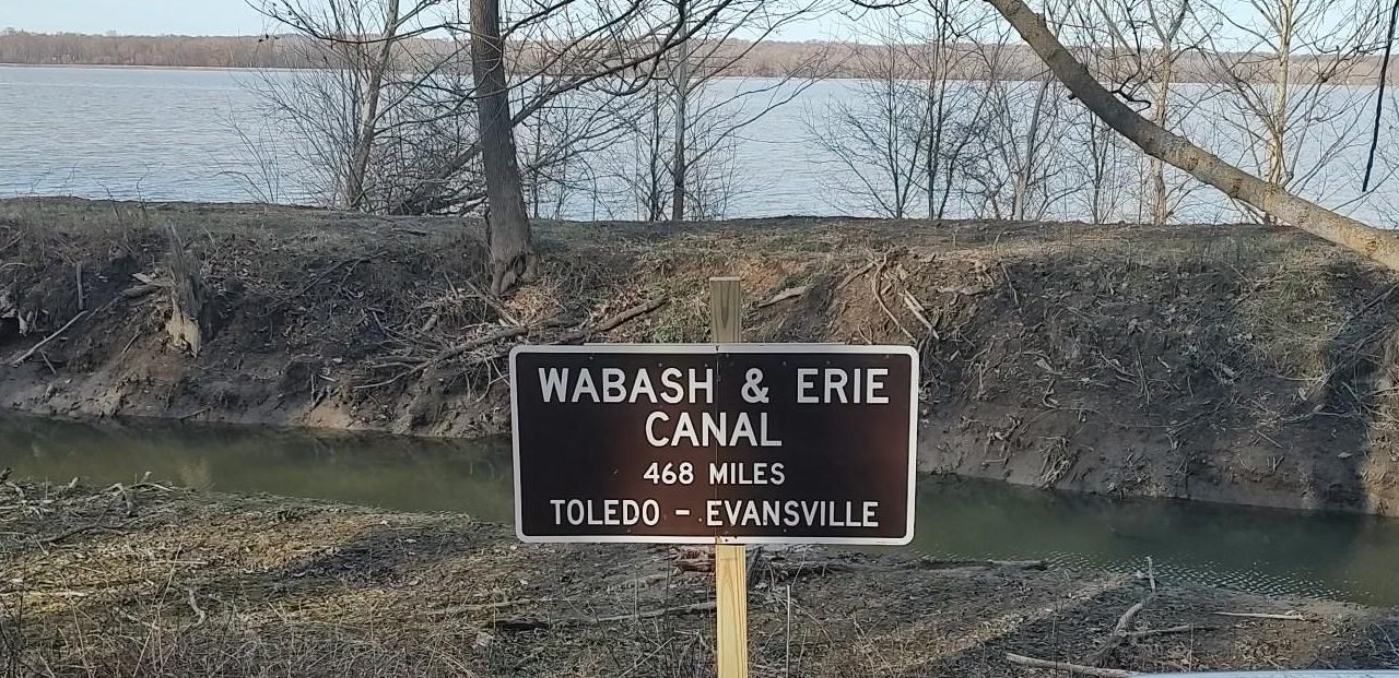
When Commissioner Jordan Vigus shoveled up that first spade full of Fort Wayne soil announcing the commencement of the Wabash & Erie Canal on February 22, 1832, there was to be a reaction as if an earthquake had shaken the land.
The ground did not shake violently as it had in 1811, but a crevice 468-miles long opened up economic development and prepared a wilderness frontier for a state of productivity. Because of the financial disappointments of Indiana’s internal improvement program including the canal, a near bankruptcy occurred causing Indiana to create a new state constitution in 1851 that prohibits the state going into debt.
Vigus’ shovel sparked the beginning of a transportation industry considering the large amount of private capital investment that followed the canal. Mills, foundries and machine shops were possible because of the considerable waterpower near locks and dam feeders. Later these were improved by steam, then by electrical power and gradually the rails and automobiles that connected them.
The canal played a role in developing the everyday economy in the region, providing employment, for today’s manufacturing and the service industries that it supports. Much of it supplies the auto and truck makers in keeping with the tradition of transporting people and the goods they demand. It is simply a newer technology than over a century and a half ago when canal passenger packets and cargo boats did the job.
Vigus’ groundbreaking shovel initiated a movement that progressed through the land from one technology to another overcoming all it encountered. With that first spade full of soil, a very long canal became a reality. Today the Wabash & Erie remains an historic reality with a very long legacy.
Bodine’s Lock Model and Display
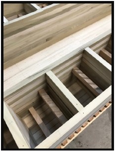
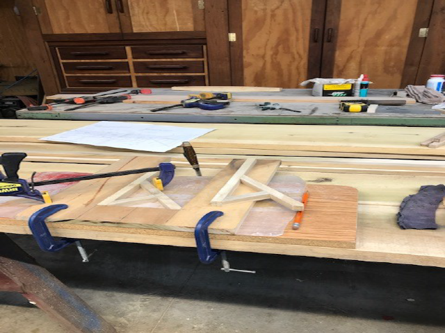
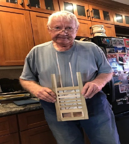
Terry Bodine, CSI Director from Covington, Indiana has made great headways with his lock model project. Here are some early pictures his wife Anne took and sent to CSI headquarters.
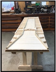

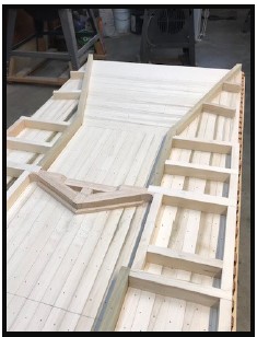
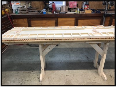
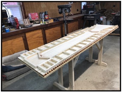
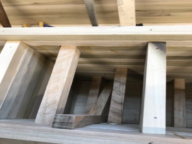
After the lock floor is built, the mitre sills against which the lock’s gates fill fit tightly when closed, are added and the cribs along the sides that support the lock walls are built. Watch as the cribs rise higher. Note that the mitre sills point upstream and that at the downstream end of the lock there is a fantail where the water flows out of the lock. The quoin posts on which the gates will turn are being held by a piece of wood across them that will later be removed. Note the recesses in the lock walls where the gates will go into when the gates are opened.


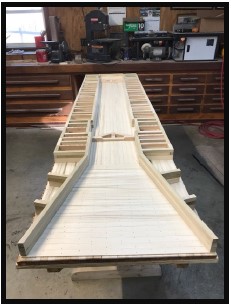
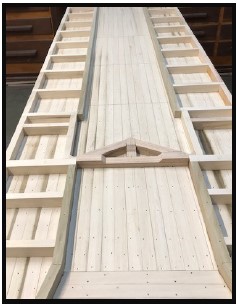
Look closely inside the cribs to see the supports. Note that baffles have been added to the fan tail to slow down the water as it exits the lock, Note how the walls of the fantail have been supported. The walls rise higher.
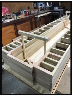
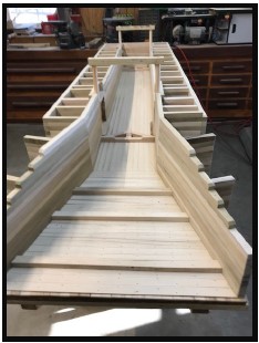
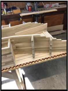
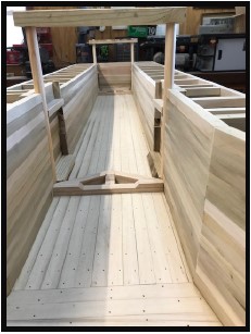

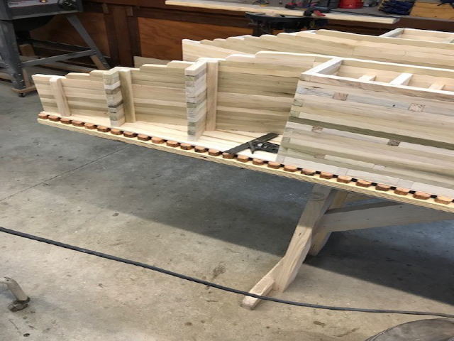


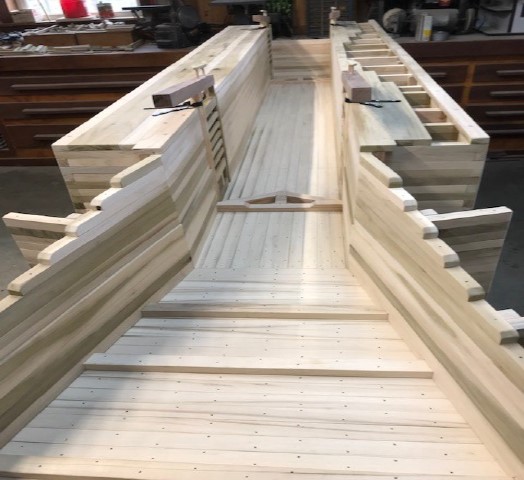

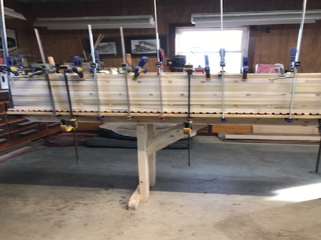

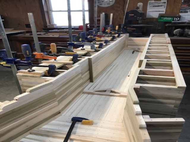


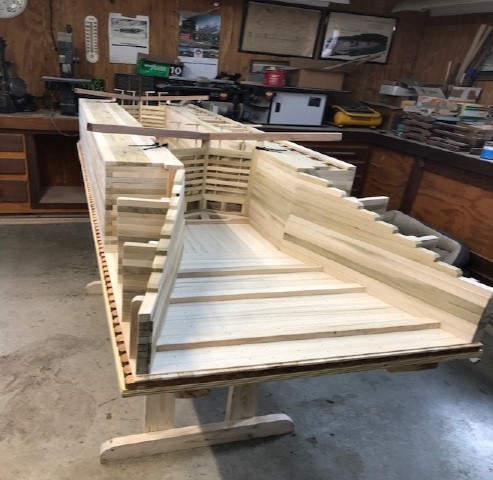
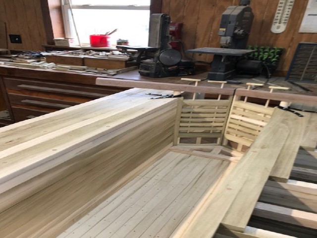
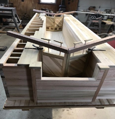
MODEL OF LOCK #36 – COVINGTON, IN.
Model Statistics:
Started Project: 12-21-2022
Completed Project: 3-11-2023
Hours: 557
Dimensions: 2′ Wide and 8′ Long
It is 5/8″ of an inch to the foot of the real lock
The Covington Lock was built originally as a Timber Frame Lock and completed in 1846. Due to deterioration, it was rebuilt in 1854 as a Crib Frame Lock. Terry’s model is a Crib Frame Lock.
The Covington Lock was one of four locks on the Wabash & Erie Canal that lifted canal boats ten feet between levels. Most locks had only six foot lifts.
The lock lasted until the end of the Wabash & Erie Canal in 1874 when the last boat “The Goodman” passed through it.
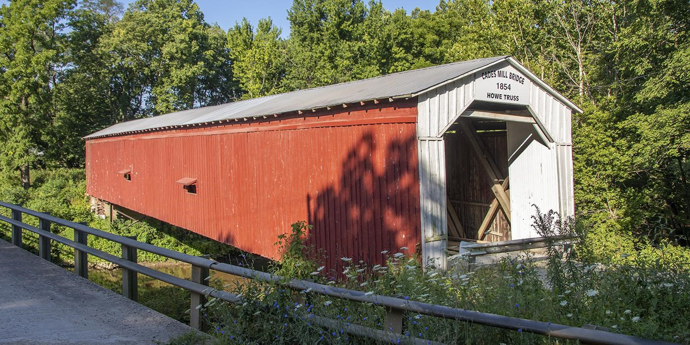
The finished model was first displayed at the 2023 Cades Mill Covered Bridge Benefit on March 12, 2023. It will be donated to the Fountain County Historical Society and will be displayed in the Covington Court House.

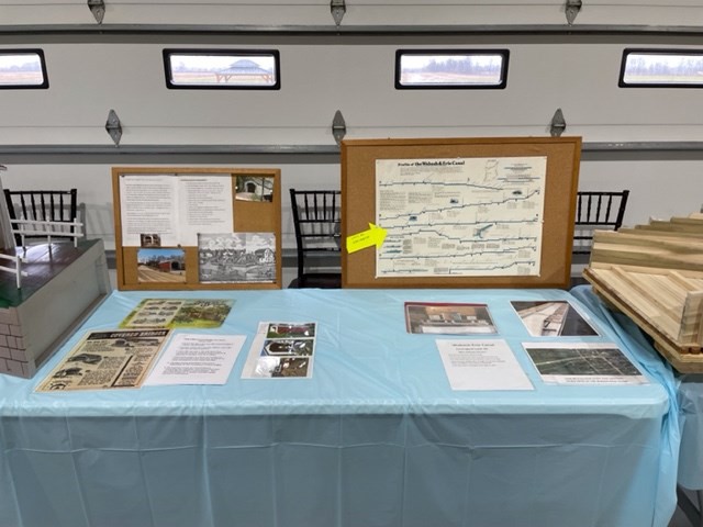
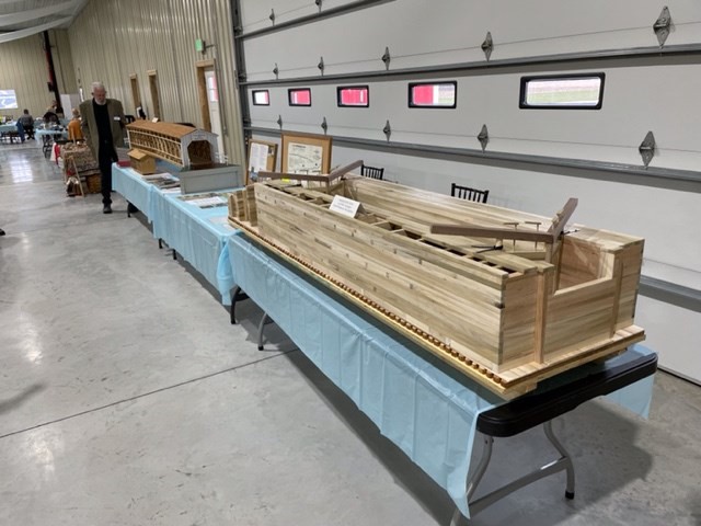

Pictured are Terry’s earlier model of the Cade’s Mill Howe Truss covered bridge (1854) on Coal Creek, his model of Lock #36 just completed, and his display on covered bridges and canals as seen at the Covered Bridge benefit to raise $800,000+ to repair the bridge. We congratulate Terry on these wonderful models!
Elks’ Property
By Sam Ligget
In 2003, having been advised that the Lost Creek Culvert remains were still visible and given their approximate location, my brother Larry Ligget (CSI member) and I set out to find these remains. At the time, they were on an over 187-acre parcel of land that was owned by the Fraternal Order of Elks on the northwest corner of Terre Haute. The Elks had a clubhouse, golf course, tennis courts, and swimming pool on this property. The clubhouse complex was on the south end of the property situated on a high bluff overlooking a bend in the Wabash River. About halfway down the bluff between the river and the clubhouse is the prism of the Wabash & Erie Canal, still very distinguishable. The canal extends the full length of the property north to south. Lost Creek cuts across the north end of the property east to west.
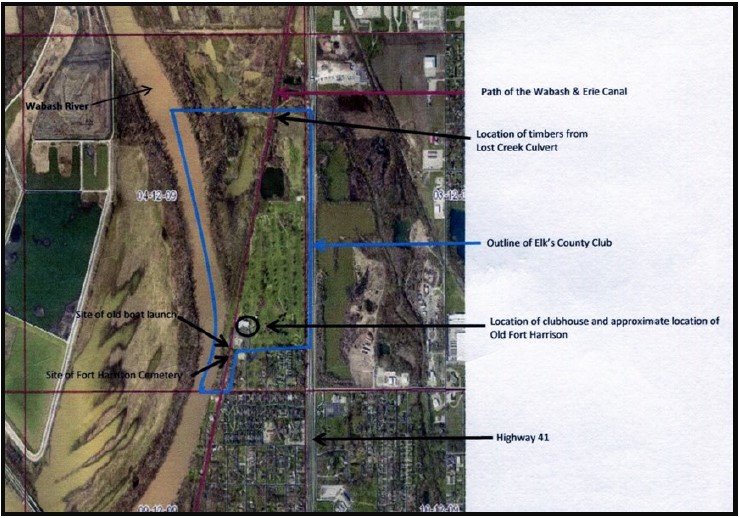
William Henry Harrison on his march from Vincennes to the Battle of Tippecanoe stopped here as his 8th camp site. Starting on October 2, 1811, Harrison’s army camped here for 25 days, building Fort Harrison and waiting on pirogues coming up the Wabash with supplies. Harrison used the return address for his correspondence from this site as Camp Bataille de Illinois. The site was destined to become Terre Haute, Indiana. The bend in the Wabash River at this location offers a commanding view of the river. Any movement on the river could have been detected from this overlook.
Fort Harrison was attacked by Native American warriors on September 3, 1812. Many historians consider this action as the start of the War of 1812. The fort was set ablaze in the attack. Captain Zachary Taylor of the 7th U. S. Infantry was the commanding officer and was able to extinguish the fire and successfully defend the fort from a much larger attacking force of Native Americans that were under the influence of British agents. South of the present clubhouse on the bluff overlooking the river and the remains of the canal is a marker on the location of the cemetery for the fort.
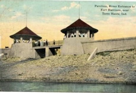
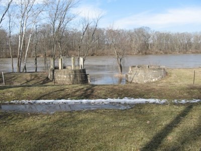
Also located on the south end of this property are the remains of a boat launch. The towpath of the old canal was dug away from this area to allow a straight path slope into the river. A set of rails were laid from where the canal had been down into the river. The purpose of these rails was to lower/raise boats to/from the river on a cradle. A turret was built on either side of the rails where boats were placed in the cradle. The turrets were built on the flat bottom of what was once the canal. Many events were held at this site on the river. It was often the staging area for boat parades. At one time, Emil Ehrmann owned this property. Emil’s brother Max, author of “Desiderata,” was a frequent visitor to this boat launch site. A statue of Max Ehrmann sitting on a park bench can be seen at the corner of 7th and Wabash in Terre Haute. The former Ehrmann factory building is a short distance away on Wabash Avenue and is now the home of the Vigo County History Center. Among other things the Ehrmanns were known for the overalls they manufactured.
Lost Creek runs across the north edge of the golf course. My brother and I started at Highway 41 and went west along Lost Creek until we found the timbers from the culvert. The timbers were about halfway between the Wabash River and the highway. Due to flooding of Lost Creek and the river over the years, many timbers were eroded out of place. Some may have escaped down the river. In one place, a few of the timbers were still lined up neatly.

This property has been subdivided since 2003. The northern part, which contains the Lost Creek culvert, has been sold off to private individuals. The south part, which contains the site of Fort Harrison, the boat launching area, the golf course, and the fort cemetery, is now owned by the Vigo Hospitality Group LLC. The property is very well maintained. The historical significance of this property that contains the fort once commanded by 2 future presidents, the canal, and the boat launch is unknown to many but a few history buffs.
Overshot Wheel Removed From Lock In Metamora, Indiana

On Tuesday Jan 10, 2023, the center of the old overshot water wheel in Metamora located behind the grist mill at the Whitewater Canal State Historic Site was removed in preparation for a new water wheel. The more than 30 year old wheel is not the original waterwheel for the canal. It weighed 6,500lbs and was removed by a large crane.
A new waterwheel is under construction off-site. It will be 14 feet in diameter and made of cypress. The wheel is projected to be installed sometime this spring.
The waterwheel was placed in the lock to power the grist mill after the canal ceased operation as a transportation canal. Whitewater canal water filled its buckets and caused the wheel to rotate while excess water flowed over the tumble at the side of the lock.
Whitewater Canal Byway Annual Meeting
The Whitewater Canal Byway Association held its annual meeting on March 15 in the Depot Building at Gateway Park in Metamora, Indiana. Each attendee was given the association’s 2022 Year End Report, which said that they were thankful to have Gateway Park due to the hard work, dedication and support from everyone. Thanks to conference calls and Zoom they were able to have quorum at their meetings. They thanked FCN Bank for hosting their winter meetings.

They began the year by being awarded ‘National Designation” at their November 2021 State Byway Conference. In March their historic Depot building was flooded for the 5th time. This led to their board asking contractors for bids to raise the dining area and kitchen with Maxwell Construction’s bid of $500,000. being accepted. Their next project was to raise $4,700 to replace 100 faded ‘Whitewater Canal Scenic Byway’ road signs, which INDOT erected for them in June. They will need to order 100 more in the near future.
Their yearly fun raiser, Metamora Canal Days, was a huge success. This year they tried self parking and it worked. Other funding comes from renting camp sites and the depot, grant funds and memberships.
The speaker that night was Dr. Ron Morris. His speech began like his article “My Trail: Walking from Laurel to Metamora” that was in the March issue of “The Tumble.” To this he added the following:
“When pilgrims traveled the routes of antiquity in Europe many times they saw ruins. Then and now the ruins fall into three categories: Engineering such as: amphitheaters, baths, or public arenas, Religious Spaces such as: churches, convents, monasteries, or temples, and Government Spaces: such as castles, forums, and gates. The ruins inspire us spiritually. They impress us by their timelessness, and they awe us by their accomplishments.

“But what do our ruins mean? What do a few scattered piles of limestone mean? What does a semi wet drainage ditch mean to us in the 21st century? I would like to share ten reasons that I think the Whitewater Canal is still important to us today:
- Culture: Life along the canal was exciting because of the interaction of people and ideas that passed along it. The newspaper and oral communication would have made taverns, canal boats, and canal side businesses busy places. The ideas of historic preservation, heritage tourism, and economic development still stir communities to move beyond what is to what could be.
- Time, Continuity, and Change: These ruins mean that our ancestors built them with their own hands with a horse, slip scoop, and cart. They cut, placed, and fit each stone in the masonry work. These monuments in our community are as tangible as the memorials at Gettysburg, Pearl Harbor, or Shanksville, PA.
- People, Places, and Environments: These routes brought the world into Indiana. The mix of people moving in or out of the area would have created an environment flush with ideas. Today that means that we have ancestors from the England, Scotland, Wales, Ireland, and Germany who came to our communities and stayed.
- Individual Development and Identity: The people who came here became Americans, and Hoosiers, and residents of Metamora. They brought their families with them or established new families here. Today this means that we have a tangible connection with people from 180 years ago with monuments scattered across our fields, roads, and backyards.
- Individuals, Groups, and Institutions: They brought their religions with them. They set up schools to educate their children, formed lodges for social support, and joined political parties. Today we see the lodges and churches on our streets including the Laurel and Brookville Seminaries founded by people who had great hopes for their children as we do also.
- Power, Authority, and Governance: The canals made an indelible mark on our state impacting the provisions of Indiana’s second constitution. The provision against state debt continues to be in force. It does force state government to live within its means.
- Production, Distribution and Consumption: Canals were a source of employment. Canal trade was a source of income for many people who made their money from the goods and services that passed through the area. Some of the money went home to families in Europe and some of it brought families to the Whitewater valley.
- Science, Technology, and Society: Canals used existing technology to enhance transportation to bring three season travel to areas that were not contiguous to water. New technology came to the Whitewater valley to harness the hydropower to make the area shovel ready for industry. The introduction of the water turbine converted each lock into a potential power location.
- Global Connections: Canals linked us with the world through the process of trade. The world came to us in products such as sugar, coffee, and silk, and we sent the world products such as whiskey. People came from around the world to the Whitewater valley some to work and others to stay.
- Civic Ideals and Practices: Government directly responded to the needs of its citizens by creating mass transportation and a freight system for the people to use. The canals represented the belief of people in the power to improve their commonwealth. This reflected the belief in the optimism of the expansion of democracy to provide more rights to the common man.

“I returned to that trail in college during the 1980s, when the Boy Scouts had forgotten about it, and it was just a wild memory. I returned to the trail as a young teacher when it was just forgotten. I thought a lot about that fifth-grade trip when I returned to Holy Hoosierland after a brief indiscression in Texas. When I returned to Indiana I visited the trail again. The route, path, and maintenance of the trail has changed over the years. The interest in the trail has radically changed and today the multi-use path for hikers, cyclists, and cross-country skiers is about eleven miles.”
“I had neither expected to come home, nor had I expected to live in the Whitewater valley, but here I was. The hills, the fields, the Whitewater River, and the Whitewater Canal always surprise and impress me. There might be a turkey that flies into the trees when approached, there might be a bald eagle buzzing over the river, or there might be the graceful blue heron following its mate soaring between the trees. What has not changed about the trail is that it is still some of the most beautiful land in Indiana. This was after all where T.C. Steele came to paint first and only later did he travel to Brown County after his wife died.”
“Fortunately for me, the trail of my youth has been recreated and improved upon to show more of the canal than I saw in my juvenile walk. On my walks from Laurel to Metamora now I pass what was the tavern and the lock keeper’s house. I wish there was interest in restoring their exterior to preserve them as the valuable Whitewater Canal resources they are. I dream of the day when the trail can extend from West Harrison to Hagerstown giving the Whitewater valley communities the recreation opportunities they desperately need for good health and an economy supplemented by tourism. I dream of the interpretation potential of an art installation at Yellow Banks that would recreate some of the physicality and dimensionality of the Yellow Bank aqueduct.”
“But enough of dreams of the future. I am very pleased to announce that the Canal Society of Indiana has created fourteen new signs marking the route and features of the Whitewater Canal across Fayette County. With the assistance of the City of Connersville and the Fayette County Commissioners these signs will be placed on town and county right of ways where canal features are visible from streets before the end of April. A huge thank you to all of the people who contributed to this effort to help us remember our history.”
Pictures by Donna Schroeder, Fayette County Historian
Metamora Citizens Called To Action
A little more than a week following the Whitewater Canal Scenic Byway Association (WCBA) annual meeting, the association put out a plea saying that they desperately needed volunteers at Gateway Park to prepare the property for the severe flooding expected in Franklin County for the next few days. Unfortunately, severe rain in the area has caused significant flooding over the last several years in the historic depot the organization preservers and utilizes as an event center.
As a result of severe flooding in previous years, the WCBA has incurred thousands of dollars in repairs due to the damage the flooding has caused within the historic depot.
In an attempt to prevent water from entering the building again, the Franklin County EMA assisted members of the organization with filling sandbags and then placing them along the outside of the building. With over 4000 sandbags to fill, the organization asked the community to come together and help.
Sandbag filling started around 2 p.m. at Gateway Park, 19067 U.S. Hwy. 52, Metamora. Volunteers were needed at that time and throughout the evening. Volunteers were reminded to dress accordingly as it would most likely rain during the process. They were also asked to bring a shovel. After many arduous hours of work by twenty-five people, all bags were filled.
Luckily the rains came from the south, which kept flood waters from Duck Creek and the Whitewater River from reaching the sandbags placed around the building. The bags will be removed after the rainy season is over.
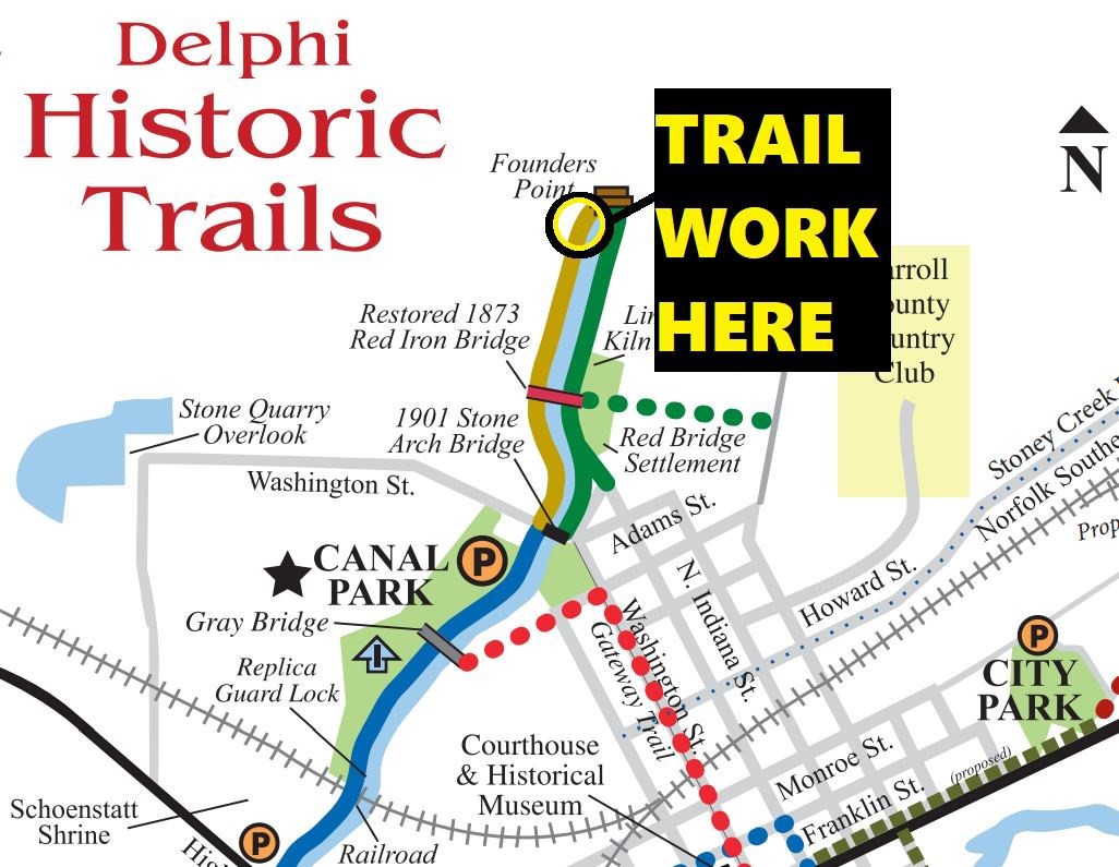
News From Delphi
Work Started On Interpretive Center Façade

In November 2022 work began on the façade of the Canal Interpretive Center. CSI members Steve and Sue Simerman stopped by to see the on going work.
New Pipes to Feed W & E Canal in Canal Park
Carroll County Wabash & Erie Canal Association reported that their friends at U S Aggregates upgraded the pipe system that feeds the canal with 3 million gallons of clean water every day! They were grateful for this valuable partnership, because moving all that water is not easy! US Aggregates are their generous neighbors who value community resources and contribute to their vitality. It’s worthwhile to note that this investment is not an obligation placed upon US Aggregates–it’s their community goodwill to fund and complete the work!


Although some work was going on, Founders Towpath Trail was still accessible. They invite everyone to hike their trails this year.

Speakers Bureau
Margaret Griffin, CSI director from Ft. Wayne, spoke
March 14, 2023 about the “Wabash & Erie Canal in Huntington County, Indiana”
Zeta Chapter of Sigma Eta Fine Arts Sorority. There were 12 in attendance.
Jeffrey Koehler, CSI director from Center Point, has had the following speaking engagements
January 17, 2023 “Amazing Interurban”
Sullivan County Historical Society at the county library, 20 people
February 11, 2023 “”The Wabash & Erie Canal in Terre Haute and Surrounding Areas,”
Terre Haute History Center, 54 people with lots of questions
In attendance were CSI director Sam & Jo Ligget. Sam and Jeff handed out CSI cards to those present.
March 1, 2023 “Amazing Interurban,” Westminster Village, Osher Life Long Learning Institute at Indiana State University
Sam Ligget, CSI director from Terre Haute presented a program
February 22, 2023 “The Wabash & Erie Canal in Vigo County.”
OLLI (Osher Lifelong Learning Institute @ISU) as part of Westminster Village “Wednesday talks.”
There were at least 50 people in attendance.
CSI members present were Leon Billing, Sandy Billing, Jeff Koehler, and Jo Ligget.
Using PowerPoint, Sam showed canal structures and their locations in Vigo County as well as discussing some of the history of these structures and events that occurred. He also showed similar structures in northern Ohio, Metamora, and Rome, NY. A good time was had by all as a “ghost” kept raising the automatic screen and the OLLI program director had to sit by the switch and put it back down! The words “Westminster Village” showed up on the slide every time the screen went up.
Planning Terre Haute-Riley Trail

Sam Ligget reports that he got a call from Vigo County Commissioner Mike Morris the evening of February 13, 2023. Mike wanted to talk to Sam about the Wabash & Erie Canal. The county is determined to move ahead with the plans to construct a trail from Terre Haute to Riley, Indiana. A good part of this trail would be along the old canal bed. Mike was interested in the history of this part of the canal and in canal signage. Plans to turn Lock # 47 into a small park are back on the county’s agenda. They are hoping to connect the trail to the park and perhaps include the remains of Lock # 48 on that connecting trail.
Sam and his wife Jo went out to Lock # 48 at the end of January. It is still visible. They also checked on Lock # 47. Nothing has changed there. Sam sent the picture of a new business across from Lock # 47.
Cedar Point Canal?

Neil Sowards, CSI member from Ft. Wayne, found this picture on E-bay that was marked Cedar Point, Sandusky, Ohio with what looks like a canal. Does anyone have any information about a canal there?
Locating Central Canal Remains
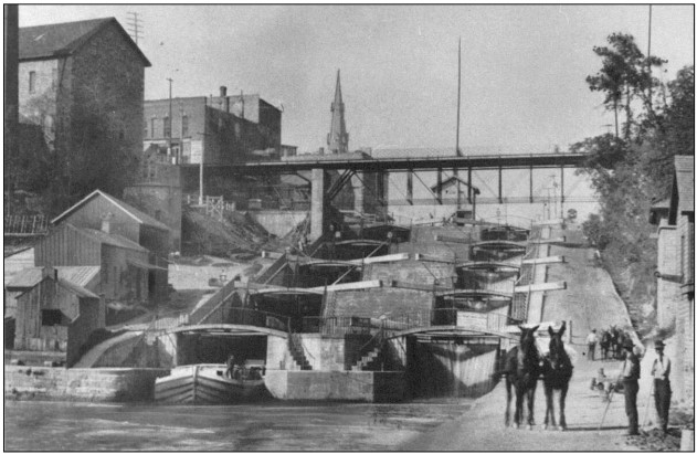
Canal Society of Indiana headquarters often gets calls asking where certain canal remains can be found. Occasionally a caller says that some canal artifact has been uncovered. Such were the cases of the Wabash & Erie Canal’s Gronauer Lock, which was uncovered in New Haven, Indiana in 1991 during highway construction, and a Central Canal Culvert, which was removed from the prism in Madison county near Noblesville, Indiana in late 1997-98 where a small lake or flood control pond was being constructed . These two events point out the importance of having sites like these pinpointed for use when planning construction projects, if we are to save them. Signage might also be placed at the sites.
Luckily both structures gained publicity in newspapers, which educated others that a canal once ran nearby. Canal Society members were also able to view the remains of both structures. They saw the culvert on the “Tracking the Central” tour on October 22-24, 1999.

A caravan of 23 cars made its way to Bundy Duck Decoys, 16506 Strawtown Ave, Noblesville. Behind its showroom, to the north about 100 feet, ran a segment of the Central Canal along the left bank of the West Fork of White River in the canal’s Northern District. Chuck Huppert, CSI Vice-president at that time, explained to canawlers that the Central Canal was originally established in Indiana’s Mammoth Internal Improvements Act of 1836 and surveyed to be Indiana’s longest canal at 296 miles long. This section was dug but never used since it was never joined to other segments. While Chuck talked the canawlers viewed the remains in both directions.
Following a tour of the decoy factory, which was thoroughly enjoyed by all participants, sixty canawlers were taken to the Central Canal Culvert by Valerie Bundy. She had alerted Chuck of this timber removal over a year prior to the tour. He and others had explored the area on February 15, 1998 and taken pictures. On the current tour the canawlers hiked to the site where the timbers from the wooden box culvert were thrown helter-skelter. Everyone was amazed at the size of the timbers and the workmanship exhibited on them. They were hand hewn and had joints.
From there the caravan went to another segment of the canal diggings behind the home of Jim Cunningham. We parked our cars on his lawn to save us a long walk to this beautifully preserved section of canal bed. We could see this segment of diggings ended at the end of his property. A short puzzling section the width of a canal extended from this segment to the White river. Several suggestions to its use were to let canal boats into the river, to remove excess water from the canal, perhaps to feed the canal though the dam was farther downstream, to turn around boats, etc. No definite conclusion was reached as to its use.

The tour’s final stop was at the White River Feeder Dam near Daleville, Indiana It was built to create a slackwater pool to feed the Central Canal’s Summit Level of the Northern Division. Since the canal itself was never finished, the feeder was completed to be used as a hydraulic canal turning mill wheels. What was built of the canal did not hold water and after several attempts was determined to be an unsuccessful venture.
Perhaps the Canal Society can put signage at these important sites and others. We need our members’ help in getting permission from the landowners to place the sign on their property and ask if they will erect the signs the society will provide. Please let CSI Headquarters know if you can be of help.


Jones Erects/Re-erects Sign
By Troy Jones—information and pictures


On Sunday February 26, 2023, Troy Jones, CSI member from Clinton, Indiana, along with help from his friend, John Muciarelli, erected one of CSI’s Wabash and Erie Canal signs after getting permission from the farmer who owns the land. It is along Towpath road just south of Howard and north of Montezuma, Indiana. Troy sent the following pictures showing the placement of the sign. Note the canal is just behind the sign, the towpath is behind it and then the flooded farmer’s field is in the background.

The weather in Indiana at this time of year was bad everywhere. On March 1 there were very high winds in the area where the sign had been erected. Troy went out to check on the sign the next day and found it spit in two and laying on the ground.
He called CSI headquarters and sent in the picture of the sign. Bob Schmidt, CSI president, saw that it was a clean split and asked Troy if he could possibly put it back together and re-erect it. Troy, with the help of his brother, Mike Jones, made a wooden frame and mounted the sign onto it. The split is almost imperceptible. Troy then re-erected the sign onto the post. He plans to add a solar light on top of the post and put a cement pad around it for stabilization and to keep the weeds down.
Troy went back a few days later to straighten the post and sign. All of a sudden he saw an alligator swimming in the canal. He couldn’t believe his eyes. About that time the farmer came up with a remote control bringing the alligator closer to Troy. They all had a good hard laugh.
CSI thanks Troy, John, Mike and the farmer for all their hard work in erecting the sign. Troy didn’t let the problems get him down. He has gotten permission to erect signs at the Raccoon Creek aqueduct and at the Coal Creek, Lodi dam site. He has talked to the Parke County park board about placing a bench on a concrete pad by the sign and is awaiting a decision. He also asked that the sign’s location be placed on the county’s map of places to visit.
A day or so later Troy followed the Wabash & Erie Canal route to Montezuma, Indiana. He found Benson’s Basin completely filled with water with just the towpath separating it from the Wabash River’s flood waters.

Memorials To Jerry Mattheis
The Canal Society of Indiana has received memorials honoring Jerry Mattheis, a Director of CSI for 23 years who passed away in January 2023. The society plans to use these memorials to place canal signage on the Whitewater Canal in the area where Jerry lived. We are asking permission from land owners or the highway department as to where they may be placed. We thank the following for their generous contributions:
- Bauer, Carl & Barbara – Ft. Wayne
- Bodine, Terry & Anne – Covington
- Castaldi, Tom & Linda
- Jesse, Sue – Ft. Wayne
- Morris, Ron – Centerville
- Schmidt, Bob & Carolyn – Ft. Wayne
- Simerman, Steve & Sue – Ossian

Richard D. “Dick” Kudner
Find-A-Grave # 249518669

Richard D. “Dick” Kudner passed away at age 95 on February 13, 2023. He was born on December 31, 1927 in Jackson, Michigan. He was graduated with the rank of Lieutenant from Indiana’s Culver Military Academy in 1945. Dick then attended the University of Michigan, majored in Journalism, was a member of the Alpha Delta Phi fraternity, and was a boxing champion of his weight class.
Following his graduation from the university he worked for the promotion department of the Jackson Citizen-Patriot, his hometown newspaper, where he had worked as a teenager. He then moved to Detroit to work as a copy writer for his Uncle Arthur’s Kudner Marketing and Advertising Agency, which led to a job in public relations. He then worked in contract relations with General Motor’s Diesel Engine Division being assigned to the Buick account in Flint, Michigan.
In 1954, he married Martha Marshall while they were still in school in Michigan, and they settled in
Birmingham, Michigan. Their daughter Carrie was born in 1957 and their twin sons Bill and Don in 1959. Dick then worked on the Champion Spark Plug account for J. Walter Thompson in Detroit before moving to Perrysburg, Ohio in 1961 to work for Champion in Toledo as Director of Advertising. Many of his 33 years at Champion were served as the Vice President of Advertising and Merchandizing. He was instrumental in the formation of the Automotive Advertisers Council and the Tune-Up Manufacturers Institute and was a recipient of the Motor and Equipment Manufacturer Association’s Triangle Award, presented for outstanding national contributions to the automotive industry.
Dick was the first to approach race car drivers with the proposition of free spark plugs in return for having the Champion logo appear on the driver’s racing suit and under the driver’s side car window. He also told track owners that Champion would paint their track walls for free in return for having the Champion logo painted on every turn wall. In 1971 his budget for these ideas exceeded a million dollars.

Upon retiring from Champion in 1990 Dick formed a consulting firm with his first assignment to coordinate the back-to-back hosting of the automotive industry’s two most significant aftermarket trade shows. He conceived the idea to print a single program for the two shows—each show getting front cover billing simply by flipping the program book over from the first show to the second.
Dick and Martha were members of the Canal Society of Indiana. They attended the September 23-24, 2011 tour on the “Blue Moon” on the Tennessee River.
Dick was a community volunteer leading many efforts including the Wood County Parks, Toledo Metroparks, Ohio Scenic Byways, Fallen Timbers, Maumee Valley Heritage Corridor, the Black Swamp Conservancy, and the Boy Scouts. He will be missed by all.
Dick is survived by Martha Marshall Kudner, his wife of 69 years; their three children—Carrie (John) Hayden, Bill (Bonnie) Kudner, and Don (Becky) Kudner; three grandchildren—John (Becky) Hayden, Katie (Cory) Gamber, and Abbey (Wes) Kemp; and seven great grandchildren—Belle, Luke, and Beth Hayden, Jack and Teddy Gamber, and Olivia and Hudson Kemp.
Witzler-Shank-Walker Funeral Home made the arrangements for a celebration of Dick’s life on February 20, 2023 at 11 A. M. at the Perrysburg Boat Club with a private burial. Suggested memorials are:
Little Traverse Conservancy, 3264 Powell Rd. Harbor Springs, MO 49740
Black Swamp Conservancy, P. O. Box 332, Perrysburg, Ohio 43552
Maumee Valley Heritage Corridor, 26919 Shawnee Dr. Perrysburg, Ohio 43551
In Flanders Fields
A Memorial Day Tribute

