

Index:
Rafting Logs on the W & E Canal
By Carolyn I. Schmidt
When the Wabash & Erie Canal was constructed through Indiana, the state was heavily forested, roads were extremely poor, and the canal was the best way to move people and products. As trees were felled the canal offered the best and cheapest way to transport them. They could be placed on canal boats, but it was more efficient to create huge long rafts of logs or lumber and float them down the canal. Needless to say, this was very dangerous to the men who guided the logs since the logs rolled in the water and sometimes broke loose.
Withers, Rom E. in his book Nature’s School: The Role of the Wabash River in the Early History of Peru, Indiana 1829-1913 writes, “Timber was one of the most common items shipped on the canal, and strings of logging rafts were a common sight. They sometimes broke loose hitting banks, bridges and aqueducts.”
An old letter from Hoffman Bros., Manufacturers of Black Walnut Lumber and Chair Stuff, &c.
To Mr. Sylvester Dinius on April 18, 1873 talks about rafting logs on the canal as follows:
“Henry telegraphed you to go to Rafting those logs at Roanoke. He was afraid the Water (in the canal) might be taken out again and also he want(s) the logs as soon as you can get them ready —will send teams down. You Can Report by letter about the trees you went to look at and now need not go up expressly to brand those logs unless you have been up as we shall have them brot (brought) up as soon as you get those at Roanoke up. Will you have any traces left that you can bring up to those other logs or shall we have some made here to send down. Will send your rafters [the rest is illegible and covered with soot]
Another old letter from D. Clippi_[missing]_ at Roanoke, Indiana to Mr. Sylvester Dinius written on April 1, 1878 talks about shipping and rafting logs. He writes, “We sent in to (two) car loads off (of) logs and have one on the road, and in all about half off (of) the Snyder logs on the canal.”
Jack Helvie related his adventures in rafting logs on the Wabash & Erie Canal to F.S. Bash as reported in a September 22, 1928 article in the Huntington Herald-Press entitled “Nephew of Champion Helvie Tells Bash of Experiences of Boyhood and As Soldier” as follows:
“Then I helped Jerry Hahn raft logs to Toledo on the canal. All I could do was to drive the horses and take care of them at feeding and resting time. It required six good horses to pull a raft like we floated and we could travel only in a slow walk. Then we were often a whole day getting through a single lock, so you may guess how long it would take to reach Toledo. We could only get a small section of the raft into a lock at one time. We had to uncouple a section at a time, pull it into the lock, close the back gate, open the head one, let the water in and when the level was reached, pull the logs into the channel above and couple the sections together again. [Locks were 15 feet wide by 90 feet long. Therefore a section of a raft had to be less than 15 feet wide and less than 90 feet long to fit in the lock.]

“It used to make the regular boat crews crazy mad to wait so long for us to get through. They’d cuss and threaten all kinds of violence if a raft-man didn’t consent to lay by and let the boat through without delay. But the man with a raft would say he was paying just as much toll as anybody else and had just as good a right to the lock as any boat crew. If often ended in a fight! They tried hard to bluff any boss but they couldn’t scare Jerry. He’d fight a whole crew if necessary. At Buttermilk lock three miles this side of Peru we met a boat. The captain was determined to go through but we were there first. He and is men started to operate the gates and then there was something doing. Jerry picked up a club and waded in, knocking ‘en right and left, and I’ll be hanged if he didn’t soon have the whole daggone crew laid out. Then we went to work locking our logs through and finally the bunch Jerry had licked turned in and helped us like good fellows.”
Then Bash ran another article in the same paper on October 13, 1928 entitled “Jacob Shaffer Tells Bash How He Tamed Horse Named After Some of Writers’ Kin” in which Shaffer told of driving McCarty’s horses for the rafting of ship timber from Huntington to Toledo. Shaffer said it took six days to get from Huntington, Indiana, to Fort Wayne, twenty-eight days to go from Fort Wayne to Defiance, Ohio, and he couldn’t remember how long it took to go from Defiance to Toledo, Ohio. He said it took a whole day to get through a lock.
Shaffer also told about pulling a canal boat loaded with lumber saying, “I drove several summers for Maux Baumgartner when he owned the two biggest boats on the entire line. He called the boats the Homier and Hoagland. Both were exactly alike and were built in a boat yard this side of Mahon [Indiana]. I don’t know whose it was but Jesse Landis saved lots of the lumber at his mill near Mahon. Baumgartner would haul a cargo of three thousand bushels of wheat. The toll paid was rated by the capacity of the boat, or rather the load carried. The load generally exceeded the tonnage reported. I have know a boat load of lumber to be rated at 3,500 feet when in actuality it had 5,700 feet.
“One time when I was driving we met Capt. Tom McConnell and our big boat of lumber took so much water to float her that McConnell was shoved clear out of the channel, where his boat settled in the mud as soon as we passed by. He called to our captain and said: ‘How much you got on?’ ‘Thirty-five hundred feet,’ was our captain’s answer. McConnell swore it was the first thirty-five hundred feet that ever shoved him high and dry clear out of the canal. But that was the way they smuggled in canal days.”
“Shaffer drove teams twenty-seven years at the lumber yard now known as the Home Lumber company. His employment there covered the management and ownership of three different firms. In earlier times he drove a fourteen-hundred-dollar team, consisting of four big horses and a span of mules owned by a timber merchant named Gregory. Shaffer also drove awhile for Henry Brown, who made a specialty of black walnut which he bought up in all parts of this county [Huntington]. Jake says he once brought in a walnut log from the Bonewitz woods in Rock Creek township that contained 1,800 feet log measure.”
Rafts of logs floated on Indiana’s canals had to follow certain rules. In 1850 the W & E Board of Trustees published a report entitled Orders, Rules and Regulations, in Relation to the Collection of Tolls, Transportation on the Canal, the Conduct of Boats and Floats, and the General Police (sp) of the Canal. Many sections of the report had rules about rafts. The one I found most interesting tells how permits had to be granted, tolls paid and how long the rafts might be on the canal, etc. as follows:
“SEC. 42. No raft or float of timber, either hewn or unhewn, shall be permitted to float or be navigated on the canal; nor shall any firewood or other split of sawed wood or lumber, be transported thereon, otherwise than on board of such boat as may lawfully navigate the same, under the penalty of ten dollars for every offence, in either of the cases herein specified; for the payment of which penalties, such raft or float, and also the owners thereof, shall be severally liable: Provided, that permits may be granted by the Collector at Fort Wayne, for rafting hewn timber, saw-logs, or lumber from the St. Joseph’s River, above the Feeder Dam, through the Feeder, and thence to Fort Wayne; also, by the Collector at Logansport, for rafting hewn timber or saw-logs from Lockport to the slack-water, and thence to the Wabash Dam; and also, by the Collector at Terre Haute, for rafting hewn timber, saw-logs or lumber from Eel River above the Feeder Dam, through the Feeder, and thence to Terre Haute; and likewise for rafting hewn timber or lumber from Sugar Creek, above the Feeder Dam, through the Feeder, and thence to Terre Haute, under such regulations and restrictions in each case as will secure the prompt payment of tolls thereon; such timber, saw-logs, or lumber to remain in the canal only so long as is unavoidably necessary, allowing one hour of day time for each mile of transportation, and ten hours of day time for putting together such raft, or then ten hours for removing the same out of the canal after reaching its destination, as the case may be.”
This was not the first year that rafts were regulated. There were various rules from the very beginning of the W & E canal’s operation.
In George E. Condon’s Stars in the Water: The Story of the Erie Canal published in 1974 he states: “A single log raft would be made up of six to ten detachable sections of logs linked together and towed as a unit by two or three horses in tandem or by a team of oxen. Each raft had a crew of four .” It is assumed that the rafts in Indiana were similar. The logs were floated lengthwise down the canal and fastened by crosswise logs at either end. At times the logs were marked for the company which had cut them down. On some canals if a log broke loose the company which cut it down was responsible for any damages it caused.
Although log rafting took place on most of the eastern canals in the United States by special permission, the rafting of logs declined when saw mills were built along the canal near the lumber camps. Once the logs were cut into lumber it was easier to ship them by the developing railroad system.
The Limpus Family Of Fayette County, Indiana
By Bob & Carolyn Schmidt
In the early years following the American Revolution and the establishment of the Northwest Territory in 1787, there was a surge of people moving west across the Appalachians. Some of these families moved into the Whitewater Valley. The Limpus family of Fayette county is representative of this movement.
John Limpus was born in the small village of Cockerham, Lancashire, England in 1755. He came to the United States in his 20’s. In 1780 he married Delilah Harrell in the small town of Shenandoah, Page county, Virginia. They settled there and began rearing a family of 5 boys and 1 girl: Twins – Enoch & Elijah, August 15, 1782; Jonathan, 1783; Levi, 1788; Mary, 1790; and the youngest, Isaac, December 31, 1792. A few years later they moved to Nelson county, Kentucky, shortly after Kentucky had obtained statehood in 1792.
The Midwest was quite a frontier when the Limpus family moved to Kentucky. Indian raids and ambushes were still a constant threat. Across the river, the Northwest Territory was still in the developmental stage. After defeating a confederation of tribes at Fallen Timbers in 1794, General Anthony Wayne negotiated the Treaty of Greenville, Ohio, in August 1795. In Indiana the boundary line between white settlement and Indian Territory was drawn from Fort Recovery, Ohio, to the mouth of the Kentucky River where it entered the Ohio River. This line cuts through the Whitewater Valley about 1 mile west of Brookville, Indiana.
While in Kentucky, John Limpus died in July 1800 at age 45. His family moved shortly thereafter to Butler county (Cincinnati), Ohio, for reasons unknown. Perhaps some of the changes in the Northwest Territory impacted their decision.

On July 4, 1800, in preparation for Ohio statehood, Indiana Territory was created. The line dividing the new Indiana Territory from the old Northwest Territory (Ohio) was straightened. Ohio then became a state in 1803. From near Fort Recovery the new boundary line ran straight south to the Ohio River. The old Greenville Treaty line in the Whitewater Valley now became part of Indiana Territory. This area was called “The Gore,” shaped like a piece of fabric. Settlers in this area were unhappy as now they were linked to Vincennes, the Indiana Territorial capital versus being linked to the commercial ties of Cincinnati.

John Conner established a trading post with the Indians in the Whitewater Valley about 1802 at the present site of Cedar Grove. More settlers followed him and conflicts developed with the Indians. The settlers pressured Governor Harrison for more land. The Treaty of Fort Wayne in 1809 added another 12 miles west of the 1795 line. The western edge of this line is marked by a plaque on a large stone on the west side of Cambridge City, Indiana. This 1809 adjustment now made most of Fayette county, Indiana, available for settlement.

Once again death followed the Limpus family’s move to Ohio, when in 1805 Delilah’s daughter, Mary, died. It is likely that the five boys ages 13 – 23 remained at home with Delilah. Over the next few years the boys chose brides and all were married in Ohio.
Levi age 20 August 30, 1808 to Elizabeth Askins
Enoch age 27 July 6, 1809 to Sarah Sackett
Elijah age 28 February 4, 1810 to Lydia Garrison Young
Jonathan age 27 July 5, 1810 to Phoebe Yeazel
Isaac age 20 August 24, 1813 to Margaret Malone
The United States declared war on Great Britain on June 18, 1812. In the west the British had evacuated Detroit at the conclusion of the Jay Treaty of 1795, but they continued to supply the Indian tribes with support against American settlers in the Midwest. The American assumption was that western militia could easily take Detroit and the war would be over.
In disgrace General Isaac Hull surrendered over 2000 American troops in August 1812. William Henry Harrison resigned as Governor of Indiana Territory and assumed command of American forces in northwest Ohio based at Fort Meigs.
In support of the war, the youngest Limpus, Isaac, at age 20, enlisted for a six month term at Hamilton, Butler county, Ohio, on September 5, 1813. He served only until November 4, 1813, when he was furloughed for illness and returned home. His service was terminated on March 5, 1814.
At the Battle of the Thames in October 1813, the British and their Indian allies were defeated and Tecumseh killed. The Indians in the Whitewater Valley continued to move further to the west and in October 1813 John Conner plotted the town of Connersville.
Isaac Limpus and his wife, Margaret, moved to Fayette county, Indiana, in the spring of 1814 and settled along Garrison Creek. A son, James Limpus, was born there at Alpine on May 7, 1814. He was the first white child born in Columbia township. Isaac’s brothers, Enoch, Elijah, Jonathan and Levi, also followed him to Fayette county. All appear in the 1820 Census except Jonathan who had died in June 1817. His wife, Phoebe Limpus, is listed next to the home of Enoch. Based on this census, their mother, Delilah, stayed with Elijah until her death in 1830. Enoch, the other twin, moved to Johnson county and died there in November 1829.


After his mother’s death, Elijah moved to Shelby county and lived there until his death in May 1853. This left only Levi and Isaac remaining in Fayette county. Levi lived at Nulltown with his wife, Elizabeth, and died there in December 1867.
Meanwhile the Isaac Limpus family grew as they continued to live along Garrison Creek: John, June 1816;, Mary Ann “Polly,” September 1819; Uriah, 1823; Emily Jane, May 1825; Nelson, November 1827; and Elizabeth Ann, November 1830. Unfortunately, Uriah died in 1828 of disease at age 5.
On February 4, 1831, Isaac purchased land in Sec 21, T13, R12 very near the future village site of Columbia. He and James Buchanan had adjoining land on which they established the small town of Columbia in 1832. Isaac built the town’s first frame house from which he operated a grocery store, saloon, post office and retailed liquor. Isaac had a small still on his property. His oldest son, James, years later, operated a larger distillery in the area. Isaac was active in his local community and was highly respected. He served as Postmaster from 1833 until 1836. His last son, William Franklin, was born in May 1833 at Columbia.
James Limpus, the oldest son of Isaac and Margaret, got married to a local girl, Rebecca Cotton, in May 1835. Their daughter, Mary Elizabeth Limpus, was born on November 27, 1836, but only a few days later Rebecca died as a result of child birth on December 11, 1836. James remained a widower for the next 10 years. Rebecca and later James were buried in the Bochim Cemetery at Laurel, Franklin county, Indiana.
By 1836, Isaac Limpus had a thriving business and six children at home from ages 3 – 20. Once again tragedy struck when Isaac, age 44, met his death when a wagon loaded with bricks ran over him. He died on December 6, 1836. Sons James and John probably took over the family business and kept the family going. Their mother, Margaret, was a durable woman and kept the household together.
The Whitewater Canal was completed 1836 – 1839 from Lawrenceburg to Brookville with some construction toward Metamora. When the State of Indiana ran out of funds, the workers laid down their tools and abandoned the effort. In 1842 the State sold its interest to Cincinnati investors and work resumed. Canal prisms were created through the forests and stone locks were built toward Cambridge City. In order to help support the family, James Limpus got a job constructing the canal.
One of the locks on the Whitewater Canal, Limpus Lock #33, was built near some of their property. This is a composite lock, having mason cut stone at the entrances and a rubble stone chamber that was once lined with wooden planks to make it watertight.

Photo by Bob Schmidt
Note the large stones down the middle of the lock chamber. They help to identify the lock.
Once the Whitewater Canal was abandoned as a transportation canal portions of it served as an hydraulic canal. The Wawassa Paper Mill was built just north of the Limpus lock on the Whitewater River bank in 1865. Its owner put a dam across the Whitewater River and diverted its water into the old canal bed that carried it to the mill. It operated until 1875. Initially local poplar trees were used to produce a variety of paper products, but, when they became scarce, the paper was made from straw purchased from local farmers. They later used corn stalks, which made a good grade of paper and used stalks that would have been plowed under. However, there was a growing demand for a more finished grade of paper, and the mill eventually closed.
Years earlier in 1842 James Limpus and his brother, John, and their partner, Thomas Crisler, constructed a saw mill at Alpine. In 1844 as partners these three built and operated a grist mill there too. James married for the second time at age 32 on December 24, 1846, to Lucetta Crigier, who was then 33. His daughter, Mary Elizabeth, was now 10 years old. James and Lucetta had one girl together, Sarah, born in 1859.
John Limpus also stayed in the Columbia area. He married Harriett Perkins and together they had at least 7 children, all surviving to adulthood and all remaining in the area of Fayette county.
Margaret Limpus, Isaac’s wife, was faced with another tragedy when her young daughter Emily Jane died in May 1841, at age 16. Margaret’s oldest daughter, Mary “Polly,” was still living with her and could help with Nelson, Elizabeth and William. For the next nine years Margaret and her remaining family all lived in Columbia, Indiana.
In 1850 Elizabeth Limpus married Phillip Powell. William Limpus, age 25, married Mary Stevens in 1858 and had his farm next door to that of his mother’s.
By 1860 only the mother Margaret, Polly and Nelson were on the farm. Polly was single until age 45 when, in 1864, she married Daniel Conner, age 74 (his 3rd marriage), but he died 2 years later in 1866. Nelson married Caroline Pearce in 1865 and moved to a farm nearby. In 1870 Margaret and her widowed daughter, Polly, were still living together.
The Civil war began in April 1861. Following his patriotic duty, William Limpus left his young family and enlisted in the Union Army in September 1861 – Company H 36th Indiana Regiment. He served in various campaigns – Shiloh, Perryville, Stones River, and Chickamauga, where he was wounded in the right thigh. He recovered and retuned home for 3 months before re-enlisting January 1, 1864. He was mustered out at Indianapolis September 21, 1864 as a Captain.
In the late 1870s, William Limpus, Nelson Limpus and Elizabeth (Limpus) Powell with her husband, Phillip, decided to move to farm land in Kansas. They were true pioneers like their grandfather, John Limpus, who had taken advantage of being one of the first to settle in Kentucky when it became a state; their grandmother, Delilah (Harrell) Limpus, who moved the family to the new state of Ohio; and their father, Isaac Limpus, who moved to Indiana Territory. They saw an opportunity to buy good farm land and to influence the development of the area.
The Powells stayed in Kansas. Nelson Limpus eventually moved to Yamhill, Oregon. In 1907 he died there. After a while William Limpus returned with his family to Fayette county, Indiana.
By1880 Margaret and daughter Polly were living with son James and Rebecca Limpus. Margaret Limpus died 44 years after her husband, Isaac, in December 1880 at age 88. James died in 1891 at age 77.
By 1900 Polly was living with her brother William, who had returned from Kansas. She never remarried but remained in Fayette county, dying there in 1906 at age 86. William Limpus, the youngest of the Isaac and Margaret Limpus family lived only a few years after Polly’s death. He died in December 1910 at age 77.
The Isaac and Margaret Limpus family came to what would become Fayette county in 1814. They reared their family in the valley of the Whitewater River. They contributed to the settlement of the county and the Whitewater Canal in many ways. Today the Limpus name remains on the ruins of Lock 33. The Canal Society of Indiana has placed a marker at the lock that can be seen today by those who ride the Whitewater Valley Railroad.
Most of the Limpus family members who stayed in Indiana are buried in the Columbia Cemetery. A few graves are in the Bochim Cemetery in nearby Franklin County.
Sources:
Ancestry.com
Indiana Marriage Index, 1806-1861 Rachel Cotton
Indiana Marriage Index, 1810-2001 Lucita Crigher
Public Member Trees: Isaac Limpus, James Limpus, and others. These were used as guides
but contained many errors in dates.
U.S. Federal Census: 1850, 1870, 1880
An Illustrated Historical Atlas of Fayette County, Indiana. Chicago, IL: Higgens, Belden & Co., 1875
Biographical and Genealogical History of Wayne, Fayette, Union & Franklin Counties, Indiana. Chicago, IL: The Lewis Publishing Company, 1899.
Find-A-Grave
Capt. William F. Limpus #41161292
Isaac Limpus #76852914
James Limpus #136754249
John Limpus #51926959
Lucetta Limpus #50357538
Margaret Limpus #51926981
Nelson Limpus #76852359
Limpus Graves, Columbia Cemetery, Connersville, Indiana
History of Fayette County, Indiana. Chicago, IL: Warner, Beers & Co., 1885.
Schmidt, Carolyn. “Towpath Tracks” Whitewater Canal, Hagerstown—Cincinnati & Whitewater – Canals. Ft. Wayne, IN: Canal Society of Indiana, 2001.
How Railroads Destroyed Canal Business
By Carolyn I. Schmidt
Although Indiana’s canals were plagued by freshets washing out their banks and destroying their structures, water leaking through porous soil especially in southern Indiana, lack of water during dry periods, decaying structures, and destruction of reservoirs by local residents, it was the railroads that led to their eventual demise. Extracts from the Report of the Canal Superintendent to the Trustees, in December, 1861 reports the following showing how the railroads worked to take away canal shipments:
“The season of 1860 opened by a phase in the management of the Railroad, perhaps necessary to its existence, but certainly unusual even in Railroad corporations. It sought to secure in its interest, at the several points of competition along its line, the business men having warehouses and therefore, doing business upon the [Wabash & Erie] Canal, by renting and closing up or removing these warehouses to the Railroad, and offering to their owners such special facilities for transportation as would enable them to defeat all efforts at competition on the part of the remaining friends of the Canal; where, from the peculiar character of the locality, warehouses could not be removed, or the usual street market was nearest the Canal, a side track was laid by the railroad to the warehouse, and its business secured by some special privilege to the occupant.”
“At Huntington they removed from and across the Canal to the Railroad, a distance of nearly half a mile, at great expense, a large warehouse, owned and occupied by a Mr. Parviance, one of the most successful merchants and produce operators of the place, and they extended to him such facilities for purchase and shipment as enabled him to divert from the Canal the entire shipping business of the town. And although there yet remains other warehouses upon the Canal, the owners, not possessing the facilities of Mr. Parviance, are unable to compete with him.”
“At Lagro, the next point of importance below, a side track has been laid to the Canal warehouses and the largest portion of the business secured to the road.”
“At Wabash, the road induced a Mr. Steele, the owner of a large Canal warehouse, and one of the avowed friends of the Canal, to close his warehouse and to do business in one upon the Railroad owned by the Company, and at rates of freight, I am advised, unknown to the public. But at this point their success was not as great as a Huntington and Lagro, for a large number of the most enterprising and liberal business men are yet the friends of the Canal and do business upon it.”
“At Peru efforts were made to withdraw business men from the Canal by propositions for special rates of freights, removal of warehouses and otherwise, and by becoming, as I have been advised, purchasers in the open market, and competitors with those who were unwilling to accept the terms proposed or who preferred to do business upon the Canal.”
“It is questionable whether this unjust competition at this point was profitable to the Railroad. I believe it has been discontinued.”
“At Logansport the effort was more successful, for nearly all the business of the town is now done upon the Railroad.” “There, as at Wabash, gentlemen have believed it to be for their interest to close their Canal warehouses against Canal business entirely.”
“At Lafayette the distance of the Railroad from the center of business and the usual market place for produce from the country, and the proximity of the Canal to it, have rendered the efforts to close Canal warehouses unprofitable; and we have therefore received from that point a fair share of the business.”
“At Attica, where the Railroad crosses the Wabash river and leaves the Canal entirely, the road has been successful in withdrawing the business from us; scarcely a boat load of grain having been shipped from that point to Toledo after their arrangements were perfected; and to induce shippers of freight from points below Attica, destined for Toledo or eastward, to ship by Railroad from Attica, instead of by Canal, the entire distance, the road has offered special rates of freight, and it would have been successful in diverting from the Canal a large share of the pork, lard, &c., packed at Covington and points below, but for the imposition of the same tolls to Attica, as were charged to the State line of Ohio.”
“I may here remark that while the road has been thus active in its effort to destroy the Canal, and secure to itself the immense carrying trade of the Wabash Valley at such prices as it might thereafter choose to establish, I have heard no business man, however large his interest upon the Canal in warehouses or other property, express any hostility to the really permanent interests of the road, as they all believe that both Railroad and Canal are necessary to the best interests of the country, and that neither should be destroyed nor compelled to do business at other than remunerating rates.”
“The Railroad having, by means I have stated, secured to its interest the shippers as far as it could be done, but not to the extent it desired or expected, the next effort was to destroy the boat interests by fixing such low competing rates of freight as would leave no profit to the boats nor even to itself.”
“The season of 1860 was devoted to securing as large a share of the shipping interest as possible. That of 1861 to the destruction of the boating interest.”
Doc. J.—27 [Documentary Journal]
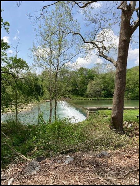
Whitewater Canal Trail Clears Feeder Dam’s Overgrowth
Volunteers from the Whitewater Canal Trail organization spent many days in May cutting down the overgrowth at the Laurel Feeder Dam for the Whitewater Canal in Laurel, Indiana. Their hard work will greatly aid the passengers riding the Whitewater Valley Railroad train in seeing the dam, waterfall, and the slackwater pool it creates to feed water into the canal. Don Vonder Meulen and Tony Montgomery played import roles in getting this project accomplished. The pictures are courtesy of the group’s FaceBook page.


Dedication Of Logansport Marker
On August 20, 2021 the marker for Mill Lock 24, a cut stone lock on the Wabash & Erie Canal that lifted or lowered canal boats 7 feet to the next level of the canal was dedicated in Logansport, Indiana. Tom Castaldi, a CSI director, worked with Thelma Conrad, Cass county Historian, to gain the approval of the Logansport city council and mayor to erect the sign donated to them by the Canal Society of Indiana. Tom learned that 30-year-old Mayor Chris Martin, who is very interested in keeping Loganport’s early history alive; a couple of his staff; and a Councilman would be on the scene to dedicate the marker, which had been mounted by the city.
Tom drove from Ft. Wayne to Logansport to attend the dedication. When he arrived he found that Pharos-Tribune staff reporter James D. Wolf had published an article announcing that the dedication would take place later than day. In the article Wolf told about the importance the canal played in connecting Logansport to the rest of the world before roads and railroads. He said the sign was in good company with the Aqueduct sign that was erected at the end of Erie avenue and others that have been erected in nearby sites along the canal route.
At the appointed time the Mayor and about 20 others arrived. After the mayor called for every ones’ attention and thanked them for coming, he turned to Tom and requested that he give a little history about the site. Tom then talked about the planning pf the canal, its construction, structures, operations, affects on communities, economy, and that it was the longest in the country. He talked about CSI’s mission to bring attention to it through its signage program.
The group seemed to be good listeners. They looked interested and asked some pretty good questions. When Tom finished they stood around the marker for a group photo.

Later in the day Cass County Online reported carried the above photo and said: A sign marking the location of Wabash & Erie Canal Mill Lock No. 24 was dedicated and Historian Tom Castaldi spoke about the canal’s history on August 20, 2021 in Logansport. The sign is located at Erie Avenue and Berkley Street.
Another sign is located at Eel River Aqueduct No. 5 behind the buildings at 5th and High.

Delphi’s Stone Bridges Placed on National Register
In early May 2021, Delphi learned that two of its stone bridges across the remains of the Wabash & Erie Canal had been placed on the National Register. On May 9, Mark Smith, Carroll County Historian, placed the following pictures of the Washington Street and the Franklin Street stone arch bridges on FaceBook.


Canal Park In Delphi Opened For Season

In preparation for the opening, they held a spring landscape clean up day on May 8, 2021 to get their pioneer village and trails ready. All volunteers were asked to wear masks and social distance. After trimming, raking leaves, picking up sticks, moving mulch, etc. they were treated to a free lunch.
Delphi Canal Days
This summer Canal Days was held on July 3, 2021 from 10 a.m. to 4 p.m. Following a parade in downtown Delphi, visitors to the park rode the canal boat, “The Delphi.” The day was absolutely beautiful with lots of sunshine and cooling breezes. The docent on the boat pointed out the turtles and fish in the canal, told how and why a canal boat operates, talked about the buildings in Canal Park, described how volunteers moved historic bridges and buildings to the park and reassembled them, and stressed why canals were important. Photos of Canal Days were taken by Bob Schmidt.


The blacksmith was busy at his forge; the school marm conducted classes; the weavers wove towels and cloth in the loom house; the cooper was busy making barrels; and demonstrations of quilting, leather stamping and paper making were given. Visitors were given a glimpse of life as it was during Canal Days.
Canal Signs Are Popping Up Around Indiana
The Canal Society of Indiana has funded signs to be placed near canal sites since 2014. The first project was donating 12 signs to the Whitewater Valley Scenic Railway for that group to erect along the Whitewater Canal locks that were passed by the train on the journey from Connersville to Metamora. All of these signs are still in good condition with only one that was stolen having to be replaced. Since then another sign has been placed for the Laurel Aqueduct.
Now seven years later, CSI has donated over 50 signs and most of them are in place. Some signs mark specific canal structures such as locks, aqueducts, culverts, dams, etc. Others are more generic giving the name of the canal and distances. They are designed to call attention to the canal in a less expensive way than Indiana State Format Markers, which have more information about the history of the site and cost around $3,000.

It usually takes at least 6 months to get a sign. It takes time to contact the Indiana Department of Transportation or local land owners, who are willing to erect a sign on their property. Sometimes the signs are erected as soon as the land owners are given them such as what happened with Dave Buffum, the owner of the property on which Stone Arch Culvert 73 over Prairie Creek near Peru, Indiana is located along Towpath Road. He had his sign up in a few days after consulting with CSI, the Allen County Historian, and the Miami County Historian.


Other marker placements seem to take forever, especially the St. Mary’s Aqueduct sign. It is located on what is now railroad property and many calls and letters had to be made before it was put up. The sign is beautiful where it is located and was well worth the wait. It calls attention to the fact that the Wabash & Erie Canal once ran through Ft. Wayne to passengers aboard the replica canal boat that plies the three rivers at Ft. Wayne or to the hikers walking the Greenway’s trail. They can view the old stones of the aqueduct’s abutment on the west side of the river next to today’s railroad bridge, which is to the right of the picture.
If you follow the signs along one of Indiana’s canals, often you will find yourself in little visited towns or rural areas where things are less hectic. Some of the sites even have water in them or very nearby. Take pictures of the signs and send them to headquarters. By this means we can keep tract of their conditions.

If you find a place for a sign, contact the property owner and get his/her permission and agreement to place the sign. Contact headquarters with the information you have gained and we will work out the details.
Thanks to Tom Castaldi, Kreig Adkins, Sam Ligget and Bob Schmidt for the above pictures.

CSI director, Preston Richardt from Gibson county, also took part in providing historical information for a new sign erected at the Pigeon Summit by the Gibson County Tourism Bureau. This sign is beautifully designed and very informative.
Forks Of Wabash Boardwalk Along W & E Canal
Tom Castaldi, CSI director from Ft. Wayne, stopped the the Forks of the Wabash park in Huntington, Indiana in July and took the following photographs of the progress being made on the boardwalk that follows the old Wabash & Erie Canal towpath and then goes down into the channel itself.


In Memoriam: Lowell Goar

Lowell Edward Goar was born on February 13, 1934 on a farm in New Lisbon, Henry County, Indiana. [When he joined CSI he said he hadn’t realized that while growing up he had all that canal history ‘in his back yard’, so to speak.]
He went to school in New Lisbon, then attended Purdue University where he graduated in 1956 with a degree in Electrical Engineering. He and Jerry Shriner, who he met at Purdue, were married in August, then traveled to California where Lowell had accepted a job with Aerojet General in Azusa. In late 1960, Lowell was offered a job at Ford Aerospace in Newport Beach, CA, so the family moved to Costa Mesa.
Lowell liked ‘problem solving’, so his ‘hobbies’ were numerous. He became interested in genealogy, and for ten years published The Gore Family Newsletter (all spellings of Gore). The four-issue-a-year publication, though titled ‘newsletter’, was always more than 100 pages.
Lowell liked projects. He re-roofed their house; put in a large paver patio; had a dark room in the garage where he printed the photos he had taken; and was remodeling the 60 year-old house, one room at a time for the past several years.
Lowell retired from Ford Aerospace in 1988. He and Jerry started traveling the United States to visit their wide-spread family and do genealogy research. They also started spending the spring and fall months taking care of the Shriner farmstead in Huntington County, Indiana, where we heard there was to be a meeting of the Canal Society of Indiana at the Huntington Library. Bob and Carolyn Schmidt
 gave an enticing presentation, and Lowell added another hobby to his list. Jerry says, “We certainly enjoyed our outings and activities with CSI. The members are delightful and have such varied interests. We learned so much!” They tried to plan their trips to the farm in Indiana to coincide with CSI events so that they could attend. They are pictured here in 2019 aboard the “Ben Franklin III” boat in Metamora and speaking with Dr. Ron Morris in Centerville, Indiana.
Lowell saw a need for CSI to have a set of Delorme maps for use in publications and tour guides. He generously donated a CD of them which has been most helpful. His big smile and helpful ways will be missed.
Lowell Goar passed away on April 26, 2021 at age 87. He was laid to rest under the care of Harbor Lawn-Mt. Olive Memorial Park & Mortuary in Costa Mesa, California.
CSI Board Of Directors Meeting
Mark you calendar! Friday, October 8, 2021 the Canal Society of Indiana will hold its Board of Directors meeting at the main/downtown Allen County Public Library from 10 a.m. to 3 p.m. followed by a tour to recently placed canal signs in the area. Let CSI Headquarters know if you plan to attend: indcanal@aol.com
Canal Clippings From Old Newspapers
The Western Register and Terre-Haute Advertiser, Terre Haute, Indiana
February 2, 1828
That, a law has passed forming a board of Canal Commissioners, to make surveys and estimates for the construction of a canal connecting the waters of the Wabash with those of the Maumee; and Samuel Hanna, Robert John and David Burr, (gentlemen no doubt qualified for the discharge of the duties assigned them by the legislature,) are appointed to form said board, with an appropriation of $2,000 to enable them to progress with their labors.
Indiana Palladium, Lawrenceburg, Indiana
February 2, 1828
CINCINNATI, Jan. 25.
We are highly gratified at being enabled to state, that the damage done to the Miami Canal by the late freshet in the Great Miami, is much less than was reported. We are informed that two or three hundred dollars will repair al the injury done to lock No. 1, which was caused by water backing up the old mill race—a quarter from whence no danger was apprehended, and consequently no provision made to guard against it. It will now, however, be effectually secured.
Four boats loaded with produce, arrived at the Basin near this city, on Saturday last, having navigated the Canal the whole distance from Middletown. The breaches in the Canal had been temporarily repaired, to enable the boats to pass. On the 20th day of January, 1828, be it remembered that the Miami Canal was not, nor had not been, impeded by ice. We have not learned that the recent freezing has been sufficient to close the canal. Republican
The Western Register and Terre-Haute Advertiser, Terre Haute, Indiana
January 3, 1829
The report of the commissioners of the Wabash and Miami canal is very favorable, and leaves not the least doubt of the practicability of this enterprise. Indeed the estimated expense is small, very small, compared with the great benefits to come from it. The entire cost of construction from the mouth of Tippecanoe river to the Ohio state line, a dist. 127 miles, is $1,081,970.00, or $8,479.55 per mile. The location is on the north side of the Wabash and south side of the Miami. [127 x $8,479.55 = $1,076,902.55]
Mr. Judah, chairman of the committee on that subject, has made a report based upon that of the canal commissioners. It recommends that the work be put under contract, as follows:
“That, the feeder line, and canal from the feeder to Little river, be placed under contract by the first September, 1829, and completed in the summer of 1832.
That, the section from Little river to Salamania, and also from the feeder east, to lock No. 1, be placed under contract by 1st September, 1830 and completed in the summer of 1833.
That, the section from Salamania to Mississinewa be placed under contract by the `1st September, 1831, and be completed in the summer of 1834.
That, the section from Mississinewa to Eel river be placed under contract by the 1st September, 1832, and completed in the summer of 1835.
That, the section from l.ock No. 1, to the Ohio state line, be placed under contract by 1st September, 1833, and completed in the summer of 1836.
That, the section from Eel river to Tippecanoe be placed under contract by 1st September, 1834, and completed in the summer of 1837.”
The committee recommends a loan for the completion of the work; a gradual sale of the lands donated by Congress, for the payment of the interest; and assume that the funds will be required as follows:
By 1st May 1830 $187,814.85
“ “ “ 1831 158,970.85
“ “ “ 1832 139,256.43
“ “ “ 1833 205,061.36
“ “ “ 1834 111,578.52
“ “ “ 1835 278,533.04
The Western Register and Terre-Haute Advertiser, Terre Haute, Indiana
January 3, 1829
Indiana Legislature — A BILL concerning the WABASH and MIAMI CANAL. [reported by Mr. Judah.]
- Be it enacted by the General Assembly of the state of Indiana, That henceforth the duties of the Board of Commissioners of the Wabash and Miami Canal, shall be executed in manner following, that is to say: _________________ and his successor at the said Board shall be known and designated as the “acting commissioner” — and __________________ and ______________ and their successors at said Board shall be known and designated as the “fund commissioners.” The board of commissioners when assembled together at such times and places as they may deem necessary, shall have the general superintendence and directions of al the concerns of the Wabash and Miami Canal. The acting commissioner shall superintend the surveying and location of the canal—shall make all contracts concerning the formation of all such parts of the canal, as shall be ordered to be placed under contract, which contract shall be in writing—one copy thereof to be transmitted to the Board of Commissioners, one copy to be filed in the office of the Treasurer of State, and one copy to be kept by the acting commissioner, and by him recorded in a book. The acting commissioner shall superintend the execution of all work contracted for. When the Board of Commissioners are not in session, he shall have full power and authority to employ all necessary Engineers, assistant Engineers and other assistants, and further to do and perform all such acts as may be necessary in the discharge of the duties required of him. The fund commissioners shall have the direction and management of the lands, granted to the state, by the act of Congress of the 2d March, 1827, and of the financial concerns of the state relative to the canal. The acting commissioner from and after the ______day of _____ next, shall receive in full for all compensation ______dollars for each year, to be paid quarterly, and the fund commissioners shall receive ______dollars, for each day each of them may be engaged in the discharge of the duties assigned to them.
- It shall be the duty of the acting commissioner to complete the survey and location of the Wabash and Miami Canal, from the Ohio state line, to Tippecanoe river, as soon as practicable upon the north side of the Wabash and south side of the Maumee river. He shall also cause the feeder line, and the canal from the feeder to Little river, to be prepared, to be placed under contract, and to be placed under contract by the 1st September, 1829. Notice shall be given, and the contracts shall be made in such manner and form as the board of commissioners shall direct. Provided, That all contracts shall contain an express agreement, that in no case whatever, shall any additional compensation be claimed by, or allowed to the contractor—and that in the case shall money be advanced, except in proportion as the work contracted for, may be actually executed according to contract.
- The fund commissions are hereby authorized to borrow upon the credit of the state, the sum of two hundred thousand dollars, at such an interest not exceeding six per cent, and payable semi-annually as may be agreed, to be redeemable from and after the expiration of twenty years, in annual installments. The said sum of $200,000, to be paid by the persons leasing the same; as follows $25,000 on the 1st September, 1829—$100,000 on the 1st May, 1836 and $75,000 on the 1st May, 1881. The fund commissioners are also authorized to select some bank of the city of New York, to receive on deposite the amount paid on said loan, and to make with such bank all necessary arrangements touching the loan aforesaid, and also to issue certificates, transferable by assignment in the name of the state, for the amount issued to the person or persons making such loan. The installments on said loan, shall be paid by the persons making the loan into the said bank of deposite.
- For the payment of the interest, upon the said loan of two hundred thousand dollars and upon such other loans as may hereafter be authorized upon account of the Wabash and Miami canal, and then for the redemption of the principal of said loan, and of such other loans as may be authorized—the lands granted by Congress to this state, and the proceeds of the same lands, and the proceeds of all tolls and of all water privileges upon said canal, are hereby appropriated and pledged.
- Money, when required, shall be drawn from the said bank of deposite, by orders drawn by the fund commissioners in favor of the Treasurer of State, unless for the payment of interest, which payments shall be made by said bank, on the order of said commissioners, to the persons entitled thereto or holders of certificates.
- It shall be the duty of the fund commissioners, to procure from the Commissioner of the General Land Office, the selection of the state lands to be made as soon as possible in such manner as will compensate this state in value and quantity, for any lands reserved or located under any treaty, which otherwise would have fallen to the portion of the state—and that so soon as such selection is made, the commissioners, at some convenient time prior to the 1st of September next, shall cause so much land as will bring in cash, the sum of 5,315 dollars, 85 cents, commencing at the western extremity of the canal tract, and exposing to sale the north east quarter of each section only, to be exposed to sale.
- The line run and marked by Col. Asa Moore, of the U. States civil Engineers, commencing on the line dividing Ohio and Indiana, near the point of its intersection with the Maumee river, thence along the south side of the Miami river to Fort Wayne, thence crossing the St. Marys above that place, to the beginning of that part of the canal located by the commissioners, and with the same to the Wabash at or near the mouth of Little river, thence resuming Col. Moore’s line along the north side of the Wabash to the mouth of Tippecanoe river in section 17, township 24 north, of range No. 3 west, be, and the same is hereby adopted as the line of the canal. And shall so remain, for all purposes connected with the selection of the lands granted to the state by the act of Congress of the 2d of March, 1827, subject to such alterations as may be necessary in the final location of the canal.
- The Register and Receiver of the Land Office at Fort Wayne, are hereby appointed agents for the state, in the sale of all lands of the state which may be ordered to be sold. The said Register and Receiver shall in all things touching and concerning the sale of said lands, or any part thereof, do and perform the said duties, and make the sale of the said lands under the same rules and regulations; and keep and render the same accounts and vouchers, as by the laws of the United States, are required of them respectively in the sale of the United Sates’ lands. Provided. That the governor of this state shall exercise the authority and perform the duties respecting the state lands, which by the laws of the United States are required of the President of the United States concerning the United States’ lands. And the canal commissioners shall be vested with the same authority, and perform the same duties, concerning the state lands, which by the laws of the United States are vested in, and performed by the Secretary of the Treasury, and commissioner of the General Land Office respecting the United States’ lands. For performing the duties required of them by this act, the said Register and said Receiver shall be allowed one per cent each, upon the amount of sale by them made, in full for all compensation, exclusive of the cost of books and stationary, and the clerk hire which may be necessary during the public sales.
- So soon as practicable from the installments on said loan payable on the 1st of September, 1829, and on the 1st of May, 1880, the fund commissioners shall apply the sum of 7,684 dollars, 15 cents, and with the sum of 4,315 dollars 85 cents, part of the proceeds of the sale of lands ordered as aforesaid, compose a fund of 12,000 dollars to be called the contingent interest fund; which fund shall be deposited in the bank of deposite for the purpose of meeting any deficiencies which may occur in the funds provided for the payment of interest.
It shall be the duty of the commissioners, from time to time to replace any part of this
fund which may by them be appropriated.
- In addition to the balance of the appropriation made by the act of January 5th, 1828, unex-
pended, the sum of 4,500 dollars, part of the installment on the said loan, payable the first
September, 1829, is hereby placed at the disposal of the commissioners of the Wabash and
Miami canal, to be by them applied in payment of the necessary expenses of the ensuing
year.
Crawfordsville Record, Crawfordsville, Indiana
January 3, 1835
Wabash and Erie Canal.—Fifteen miles of this canal are now ready for use [at Ft. Wayne], and were filled with water two or three weeks ago; but in consequence of a small breach occurring at “the bluffs” on the Feeder Line, it became necessary to close the guard lock, and draw off the water. The breach is now repaired, but we understand the canal will not again be filled until spring, at which time it is probable that the canal will be ready for navigation to Huntington, a distance of 30 miles. By filling the part already finished, the waters of the little St. Joseph were diverted from their natural course, and instead of hurrying over the Falls of Niagara and finding an outlet to the Ocean through the Gulf of St. Lawrence, they passed thru’ the waste weir to the canal, at Marie d Perches, into one of the tributaries of the Wabash, and thence by the Mississippi, on to the Gulf of Mexico; thus uniting with the Ocean at the opposite extremity of our vast territory from the one which nature intended.—Fort Wayne Sentinel.
Indiana State Sentinel, Indianapolis, Indiana
February 6, 1847
Wabash Express, Terre Haute, Indiana
August 24, 1853
Explosion — On Friday last, the steam boiler belonging to H. B. Smith’s warehouse exploded, tore its way from the basement of the building through three floors loaded with grain, and the roof of the house and fell outside into the [Wabash & Erie] canal.—The engineer, Mr. McMillan, was so badly scalded that he died the next day in excruciating pain. Nobody to blame, except fire and water, and perhaps an imperfect boiler, and bad management of the engineer.