

Index:
Unite Evansville and Lamasco
When two towns rise up side-by side, it is logical to unite them into one. This was the case of two towns along the Ohio river in Vanderburgh county, one of the smallest counties in southern Indiana. In 1818 Vanderburgh county was carved from Warrick and Posey counties. A Kentucky frontiersman, Hugh McGary, started a small village there and, by befriending Colonel Robert Evans in the Indiana legislature and promising to name a town in his honor, this village became Evansville. Soon it grew as an important steamboat refueling stop on the Ohio river since steamboats consume an enormous amount of timber to feed their boilers.
Evansville was located at the apex of a horseshoe bend in the Ohio river just east of Pigeon creek. The creek was named for the flocks of Passenger Pigeons that roosted north of there.
Changes in transportation occurred as the steamboat replaced the flatboats and keel boats on the river. By 1830 the area’s population was still less than 1,000, but it was growing as the steamboat traffic grew.
In 1836 another dramatic change in transportation was put underway. In the East the Erie Canal, begun in 1817 and completed by 1825, had immediately become a huge success. Ohio had broken ground on two canals in 1825. Indiana wanted its own canal system but struggled in trying to figure out how to pay for it. In 1827 Hoosiers sought the help of the United States Congress, which decided to raise the funds for internal improvements by selling the unsold federal lands that had been surveyed for settlers. The Indian tribes were reluctantly being persuaded to move off their hunting grounds to land west of the Mississippi river and land was opening up for a canal route.
A major factor that convinced Congress to raise funds for these internal improvements was the War of 1812. They saw the need for a better means of transportation to move troops and materiel quickly around the country for defense purposes. The Erie Canal, which was entirely privately funded by the State of New York, had proven to be a viable means of moving goods and people.
Congress used the vast lands of the west to fund internal improvements. The first such project was a land grant to Indiana and Ohio of land that could be sold to create funds for building internal improvements.
In 1832 Indiana began building the Wabash & Erie Canal west from Ft. Wayne toward Huntington. In 1837 they began construction east from Ft. Wayne toward the Indiana/Ohio state line. By 1840 the canal was opened as far west as Lafayette. Ohio was to complete this canal from the Indiana/Ohio line to Lake Erie. However, Ohio started building the canal from Toledo west in 1837 and didn’t reach the state line until 1843. But what about transportation for the rest of the state?
The clamor for internal improvements weighed heavily on the legislature. In 1836 they created the Mammoth Internal Improvement Bill to build canals, railroads, roads and a waterway improvement. Governor Noah Noble signed the bill on January 27, 1836. The key project for Evansville was to be a Central Canal that began branching off the Wabash & Erie Canal near Peru, Indiana, extended through Indianapolis, and followed the White river valley to Point Commerce (Worthington) and then south to Evansville.
Two events occurred as the proposed canal route became known. First, anticipating a great commercial opportunity, a group of investors, lawyers and politicians from Terre Haute purchased 700 acres of land just north and west of Evansville along the east and west side of Pigeon Creek in 1836. They were John and William Law, James B. McCall and Lucius H. Scott. They plotted out a town next to Evansville and called it Lamasco, a combination of the letters in their last names. Its boundaries ran west from First Avenue to Pigeon Creek and beyond to today’s St Joseph Avenue and north to Maryland Street. German was the language of this “Westside” town of Lamasco, while English was spoken in Evansville.
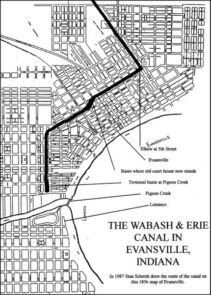
Secondly, local contractors built 18 miles of the Central canal from a basin in Evansville to a dam on Pigeon Creek north of Millersburg. This one level had no locks. The developers of Lamasco were successful in getting the canal extended from the basin, where the old Vanderburgh County courthouse is now located, to the banks of Pigeon creek along Indiana avenue in Lamasco.
The plans for completing the Central Canal to the north by the early 1840s were delayed by Indiana’s financial difficulties. In 1847 private investors took over the Wabash & Erie Canal from the state and were required to extend that canal, which had just reached Coal Creek in Parke county, all the way to Evansville. Thus the Central Canal in southern Indiana became part of the Wabash & Erie Canal. The first boat on this completed canal did not reach Evansville until 1853, although that portion built as the original Central Canal was operational.
During the intervening years river traffic increased. By 1850 Evansville’s population was over 3,000. A railroad was completed from Evansville to Terre Haute. The canal, anticipated by the developers of Lamasco, had basically failed. Even before the first boat arrived on the canal there were voices being raised to unite these two towns on the Ohio river.
The Evansville Daily Journal of Evansville, Indiana carried the following article giving reasons for uniting Evansville and Lamasco on February 9, 1853:
(For the Evansville Journal.)
Evansville and Lamasco.
- EDITOR:—In addition to the reasons given in my former communication why Evansville and Lamasco should be united, there are others of great weight which should not be overlooked.
There would be a considerable sum saved to each in the item of “ordinary Expenses.” One set of officers would do the business of both; one Mayor, Clerk, Marshal, Assessor, Collector, Treasurer, Engineer, Market master;—and the increase of salaries, over what Evansville now pays, would be small compared with the increase of population and wealth.
Before many years it will be necessary to provide a city hall, with offices, and a city prison, for each, if they remain separate; whereas one would answer equally well the purpose of both.
The projects of constructing plank roads from Evansville to Newburgh, and from Lamasco to New Harmony, or in that direction, sleep only for the present, and will soon be revived, and in order to construct those roads, Evansville and Lamasco must take stock or lend their credit in some form.
In a short time it will be necessary to erect water works to supply Evansville and Lamasco with water. The canal [Central Canal, later Wabash & Erie Canal] will be completed and in full operation by July next at farthest, and from that time forward coal will be so much cheaper than wood, that it will be generally used for all purposes except cooking, and for that purpose also in large establishments.
Then we shall be compelled to abandon our cisterns, or at least waters for certain purposes must be procured from some other source. Now is the time therefore to procure a site and begin to prepare for water works.
It will be impossible for us to get along much longer without a city-hospital and a pest house.
A little reflection would enable me perhaps to suggest several other public works which must be done, and each city must do its own, if they continue separate; and the cost would necessarily be twice as great as if the two cities were united, and the public works located and constructed with reference to the necessities and convenience of both.
It is the universal practice of the cities of the United States to borrow money for a term of from ten to twenty five years. Instead of taxing the citizens to pay for public works as they are made; and it is unquestionably good policy to do so. While the debt is maturing, all the sources of revenue ——[words unreadable]—— also may be raised by taxation, and the process of paying so gradual as to be scarcely felt. Upon public works of the character I have mentioned, depend in a great measure the growth and prosperity of the city Without them our city will soon be finished.—With them we must prosper as no other city on the Ohio, except Cincinnati, has ever prospered. United, Evansville and Lamasco can, by the sale of their bonds, raise all the money they need, but acting separately they will find it difficult to do so.
There must be a union of the two cities some time, and the sooner the better, for every year’s delay will increase the difficulties of adjusting the terms of Union. Each will continue to construct public works, subscribe for stocks, acquire property and contract debts and obligations. Now it is comparatively easy. Lamasco owes but a small debt, the wharf of Evansville can be made to pay for itself within seven years, and in the same time her cemetery will yield a net profit upon the cost, of not less than $12,000 and perhaps $20,000. The dividend, upon her railroad stock will unquestionably pay the interest on her railroad debt as soon as the road is completed, and before any part of the principal is due, the stock will undoubtedly be at or above par; so that in order to get rid of that debt, it will only be necessary to sell the stock. There is therefore no reason why the pecuniary condition of either should cause the other to hesitate.
While our interests, as individuals and communities, strongly urge union, our pride and the spirit of emulation should have full sway.
Evansville and Lamasco are in fact but one city. They are divided but by an imaginary line of which strangers have no knowledge, and we take no trouble to inform them of it, however much it may influence our conduct towards each other.
We wish strangers to consider Evansville and Lamasco, and all the enlargements of each as one city, and this desire is one of the best evidences, that they ought to be one. We are comparatively young and weak. We are struggling for a prominent position among the cities of the west, for the foremost position amongst those of Indiana, and united, we shall find no difficulty in attaining both; separately it will be much more difficult. Let us unit therefore, and, with good will and heartily, exert all our energies for the common weal. J.
——
The street that divided the two towns was Division street, a very appropriate name. Although cries were made much earlier to unite the two towns, it wasn’t until 1857 that Evansville annexed the portion of Lamasco that lay east of Pigeon creek, which incorporated all of the canal works. The portion of Lamasco (sometimes called Independence) that lay west of Pigeon creek still survived until 1870 when it too was annexed into Evansville. In 1982 the Lamasco and Independence districts were recognized as significant historic districts within the city of Evansville.
A Canal Role In A Movie
By Sam Ligget with photos by his father Samuel H. Ligget
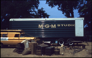
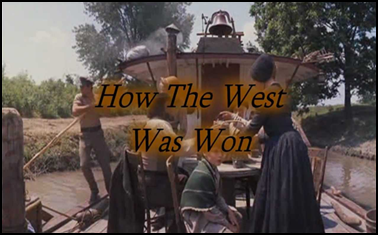 In 1961 my family joined some friends on a fishing and camping outing to Land Between the Lakes in Kentucky. Our friends had arrived a few days before us, and they had learned that Metro Goldwyn Mayer was set up in the nearby community of Smithland, Kentucky, filming parts of the movie How the West Was Won. We decided to take a day off from camping, fishing, and boating to see the set of a major movie.
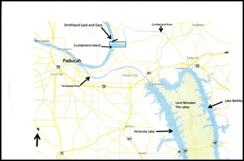
Smithland, Kentucky, is on the Ohio River about 15 miles northeast of Paducah, Kentucky. The population of Smithland was around 400 at the time. A lock and dam on the Ohio River is located there. The Cumberland River empties into the Ohio at Smithland. South of the town are Kentucky Lake and Lake Barkley that form Land Between the Lakes. Lake Barkley was formed by damming the Cumberland River, and Kentucky Lake was formed by damming the Tennessee River. Cumberland Island is in the Ohio River just offshore from Smithland. Some of the wilderness scenes in the movie were filmed on Cumberland Island.
How the West Was Won was released in 1962. It was directed by Henry Hathaway, John Ford, and George Marshall, produced by Bernard Smith, written by James R. Webb, and narrated by Spencer Tracy. The cast included Henry Fonda, Karl Malden, Carroll Baker, Carolyn Jones, James Stewart, John Wayne, Richard Widmark, and many, many more.
The movie grossed $50 million on a budget of $15 million. It was nominated for 8 Academy Awards and won 3. In 1997 it was selected by the Library of Congress to be preserved on the National Film registry for its “cultural, historical or aesthetical significance.” Other movies released in 1962 were The Longest Day, Lawrence of Arabia, The Music Man, Mutiny on the Bounty, and To Kill a Mockingbird.
At the start of the movie, Zebulon Prescott (Karl Malden) and his family set out from Albany, New York, on the Erie Canal bound for the western frontier. Their canal boat is the “Flying Arrow.” In the movie, it’s as if the Prescott family suddenly gets off the canal boat and gets onto a raft going down the Ohio River. I’ve never figured that out! The movie is about 3 generations of a family and their struggles with pioneer life in the period of the 1830s to 1890s, including the Civil War era.
Smithland, Kentucky, is turned into Albany, New York, for the purpose of making the movie. It is interesting to note that the signs on the sides of the buildings are really large canvas paintings. The canvases have large poles on the top and bottom that keep them stretched out over the sides of buildings making them appear to actually be the sides of the buildings. Another cover-up was to simply erect a large sign of plywood and mount it on the building to hide existing signs or add to the look of a building from the time period being represented.
There were many newer homes in Smithland close to the area where the filming was taking place. The newer houses were covered up by what looked like stockade walls. Many of the homes in town had television antennas and, of course, utility lines ran up and down the streets. The TV antennas were taken down and were lying on the ground next to the houses.
We didn’t get to see any movie stars. They were filming out on Cumberland Island the day we were there. We did get to see the techniques used by the production company to make Smithland appear to be Albany, New York in the 1830s. The Erie Canal in the movie appears to be very narrow. I don’t know where the canal scenes were filmed, but it may have been in the channel of the Ohio River near Smithland . I made an effort to find where the canal scenes in the movie were filmed, but to no avail.
Wabash & Erie Canal of National Importance
By Carolyn Schmidt
The Evansville Journal of September 12, 1844 carried the following article on its first page. A few places are marked where the text is missing. Capitalization and spelling are inconsistent throughout the article. The highlighted portion points out the reason the Wabash & Erie Canal was of extreme importance to the United States before more modern means of transportation were available.
TO THE HONORABLE, THE SENATE AND HOUSE OF REPRESENTATIVES IN CONGRESS ASSEMBLED.
The Memorial of the undersigned citizens of Indiana and others, would respectfully represent unto your Honorable Body; That by an act approved March 24, 1827, a certain quantity of Land equal to one half of five Sections in width on each side of the line of the Wabash and Erie Canal, reserving such alternate sections of land to the United States, was granted by Congress to the State of Indiana, for the purpose of aiding the State in opening said canal to unite at navigable points, the waters of the Wabash river with those of Lake Erie. By the first action of said Act, it is provided; “That said Canal when completed, shall be, and forever remain a “PUBLIC HIGHWAY FOR THE USE OF THE GOVERNMENT OF THE UNITED STATES, FREE FROM ANY TOLL OR OTHER CHARGE WHATEVER FOR ANY PROPERTY OF THE UNITED STATES OR PERSONS IN THEIR SERVICE PASSING THROUGH THE SAME.” By the Act of May 29th, 1830, there was granted to said State twenty-nine thousand five hundred and twenty-eight acres and seventy-eight hundredths of the public lands, to be selected by the Canal Commissioners of said State of Indiana from the alternate Sections reserved to the United States, in the division made under the before recited Act of March 2nd, 1827, in lieu of the aforesaid quantity of land before that time sold by the United States and permanently reserved by treaty to individuals and located by individual grants before the division aforesaid, and which would otherwise have become the property of said State in virtue of the action referred to. By a further act of Congress, approved June 30th, 1834, it was provided; “That in lieu of the lands sold or otherwise disposed of by the United States within the State of Ohio, and which would otherwise become the property of the State of Indiana by virtue of the grant made to that State under the act of March 2nd, 1827, the State might select an equal quantity of land from the alternate sections which would otherwise belong to the United States in the division under said act, or from other lands in the neighborhood near the line of the canal, as should be thought proper, and the lands thus selected should be vested in said State of Indiana and disposed of for the use of said canal, as other lands appropriated by the act first recited.”
Under these several acts of Congress, the lands donated by the General Government to the State of Indiana, “for the purpose of opening a canal to unite at NAVIGABLE POINTS the waters of the Wabash River with those of Lake Erie,” have been received by said State and applied in accordance with the terms of the grant, to the construction of a canal from Maumee Bay on said Lake, to the town of Lafayette on the River Wabash and the canal between said points has been completed and is successfully navigated. After the completion of the canal to Lafayette, the question arose, where is the NAVIGABLE POINT on the River Wabash at which said canal shall terminate? The subject was referred to the Commissioner General of the Land Office, by him to the Attorney General, and it was ultimately determined, after a full examination of the matter in all its bearings, and by a liberal construction of the act of 2nd March, 1827, that Terre Haute, on the Wabash, was the navigable point on the river within the meaning of said act. Pursuant to that decision, a quantity of land equivalent to that granted by the act of March 2nd, 1827, that is to say “one half of five sections in width on each side of the canal,” has been selected, surveyed and partially sold to complete the canal from Lafayette to Terre Haute, and the same is now under contract the whole distance. The canal will doubtless be complete and perfect internal navigation from Toledo on Lake Erie to Terre Haute in Indiana, a distance of about three hundred miles—the longest work of the kind in the United States, and probably in the world! In the system of Internal Improvements adopted by the State of Indiana in 1833, it was proposed to connect the Wabash and Erie canal “with the southern portion of the Central Canal,’ by means of the “Cross Cut Canal” from Terre Haute to the Feeder Dam on White River, at the town of Newberry, in Greene county. The southern portion of the “Central Canal” terminates at Evansville, on the Ohio River. In the prosecution of this undertaking, a large amount of money has been expended by the State both on the “cross cut” and the “central canal.” On the ‘crosscut’ from the Dam on Eel River to Terre Haute, a distance of twenty-five miles, most of the work is completed, including the dam, and as the contractors on “the Wabash and Erie canal” from Lafayette to Terre Haute, have contracted to finish their work also, in addition to the “Wabash and Erie canal,” between the points above mentioned, there is no doubt that their operations will be simultaneous, and that the portion of the “cross cut,” from the dam on Eel river to Terre Haute and the Wabash and Erie canal to the same point, will be finished at the same time. Thus affording an internal navigation from Toledo on the Maumee Bay (by means of the Wabash and Erie and the cross cut canals) to the feeder dam on Eel river in Clay county, Indiana.
Your memorialists would further represent that in that portion of the work from the Feeder dam on Eel River to Evansville on the Ohio ( a distance of one hundred and seventeen miles) there has been expended by the State the sum of $517,092. In 1839 the canal was finished from Evansville to the feeder dam on Pigeon creek (a distance of eighteen miles) and boats then commenced navigating it between these points. The most of the heavy jobs have been completed on the line to wit: The embankment on White river and the deep cutting on Patoka; on which already have been expended $279,000. That the amount required to complete the whole line from Evansville to Terre Haute, according to the estimates of 1839-40, was $1,659,192. From this deduct the cost of finishing the twenty-five miles (now under contract as before stated,) from Terre Haute to the feeder dam on Eel river, fixed by the same estimates at 77,299, and it will leave the balance necessary to complete the canal from Evansville to the feeder dam on Eel river, at $1,581,898. But as these estimates were made at a time when the prices of labor, provisions, &c. were much higher than they are at present, it is reasonable to suppose that a deduction of fully one fourth may now with safety be made from the same, thereby reducing the cost of the unfinished part of the canal to a sum not exceeding $1,158,424.
The expenditure of which sum will furnish a continuous line of internal navigation from Toledo, on the Maumee Bay, to Evansville, on the Ohio River, a distance of about four hundred and fifty miles [468 miles] passing through a country rich in soil and abounding withal the elements necessary to make a great prosperous and happy people.
Your memorialists would further represent: That so far as the United States are concerned, the stoppage of the Canal at Terre Haute, on the Wabash, renders it perfectly useless as a “public highway for the use of the Government.” The Wabash River, (as is known to all acquainted with it,) is not navigable on an average for more than four months in the year. The obstructions at the Rapids of that River, prevent the passage of the Boats, one year with another, longer than the period above stated, and even if these were removed, such is the scarcity of water in the River itself, that it is doubtful whether it could be navigated more than one half of the year. It then appearing that the Wabash has no navigable point at all seasons, even below the Rapids of the River, short of its confluence with the Ohio, and it being impracticable to extend the Canal to the mouth of the Wabash; would it not be in accordance with the spirit of the original grant, and infinitely more advantageous to the Government and People, to make the Ohio the terminus of the Canal? Your memorialists believe that this when completed will be a great NAVIGATIONAL WORK. It is the only one in the United States known to your memoralists, in which the Government has an interest. When [one line of text is missing] grant shows it was intended to be, in a National point of view, a great “Public highway for the use of the Government of the United States —free from any toll or charge whatever for any property of the United States, or persons in their service passing through the same.” Let any one take the map of the United States, and cast his eye along the valley of the Mississippi, from its mouth to the mouth of the Ohio. Thence up that stream to Evansville. Thence along the line of the canal to Lake Erie. Thence to Buffalo—to New York—to Boston. Let him look at the various lines of communication between Lake Erie and the immense country bordering on the lower Mississippi. What work can be completed so cheaply, and so directly and advantageously affecting the interests of so many of the States of the Union? It is no sectional work. It is National in every point of view. In what work of Internal Improvement are so many States of the confederacy interested as this? Terminating but a short distance (some 7 miles) below the mouth of Green River in Ky., the whole southern portion of Kentucky, Indiana and Illinois, are interested in its completion. Tennessee, Mississippi, Louisiana, Arkansas, and Missouri are equally if not more interested, and we may add Alabama, and the Floridas. Passing on through to Lake Erie, the northern portions of Ohio and Pennsylvania, the great State of New York, and all the New England States have a direct interest in the completion of this great work.
 It opens the only direct outlet between Lake Erie and the valley of the Mississippi. The Manufactures of the North will, through this medium, be exchanged for the rich products of the west and South-west, and the latter through the same will find their market in the North. In case of war, and the States being blockaded by foreign forces, where will the whole cotton and Sugar of the South Western States—the hemp and tobacco of Tennessee and Kentucky find a market, but through this outlet? When the Pork, Flour and agricultural products of the fertile portions of Southern Indiana and Illinois—and where we would ask, will the munitions of war, and the troops of Government, find a safer, easier, and cheaper route, from the North to the Valley of the Mississippi?—than through a canal so direct, and on which the United States are freed “from any toll or charges whatever!” Your memorialists therefore contend that the work is NATIONAL in its character in the highest degree, and that any grants made to it , are freed from all these constitutional objections, heretofore urged against similar undertakings by the Government.
Your memorialists ask no pecuniary aid from the Government. Without burthening itself, or the people by the direct application of funds from the National Treasury or by drawing upon any resource, directly applicable to the immediate wants of the Government, Congress has the power to complete this great National thorough-fare.
The first, act for the disposal of the public issue, in the Vincennes land district, was approved March 26th, 1804. The first public sale of lands in that district, took place in 1807, at Vincennes, and from that time to the present, the Land offices have been open there, for the private entry of lands in that district. By the returns from the Commissioner of the General Land Office, to the date of September 20th, 1843, there had been sold in the district 2,992,594,55 acres—Remaining unsold at the same date 1,635,434,73 acres—Total land in the district, 4,627,729,28 acres. Thus it will be seen that after an exposure to public and private sale, of the lands in the District for thirty-six years, there yet remains the large amount of one million six hundred and thirty-five thousand one hundred and thirty-four acres and 73-100 of an acre of refused land. Which if the land offices are kept open for a half a century to come, will not be disposed of. These lands it is believed, would, if the canal was completed, become valuable. As the country now is, they are comparatively worthless to the Government, and yielding but little, if any revenue. That they are refuse lands, and seldom purchased. That they were offering but a small sum to the Government after deducting expenses, is evident from the sales made at the land office at Vincennes, for the year ending September 30th, 1843. The whole amount of sales for that year, were $16,253 and from that sum is to be deducted the salaries of the Register and receiver, their percentage and all the expenses of the offices leaving probably to the Government a net receipt, for the year of only about $14,000.
Your memorialists believe, that under this state of things, it would be better for the United States, for the citizens of Indiana—and for those of the whole Union that a grant should be made of said lands, to the State of Indiana, for the purpose of completing the great work of Internal Improvement above referred to, thus opening a direct communication between the Lake and the Ohio. A work deeply interesting to the Government itself. National in its character; and in the completion of which so large a portion of our confederacy are interested. The State of Indiana has not the means of prosecuting this great work to its completion. She has already expended, as will be seen, the large sum of $517,092,00 on it. The work is now abandoned and must remain so unless the chief party interested in it, the Government of the United States, comes to the rescue. It is beyond the reach of private enterprise, and but for aid from the U. States, this great National work must remain unfinished [missing] while that portion completed by the State of Indiana is fast crumbling into decay, and the $517,692,00 already expended be lost to her citizens.
Your memorialists believe, that in case of war, the saving alone in one year to the U. States, in the transportation of their troops and munitions or war, from the East and North East, to the West and South West, with the great facilities afforded the same portions of the Union, in the exchange of their products, would more than repay the whole sum to be expended, aside from the fact of an increase of great agricultural wealth in the Valley of the Mississippi, and the new bond which such a work would create between the distant portions of our common country.
In view of all which your memorialists would respectfully ask of your Honorable Body to pass an act, granting to the State of Indiana, the lands in the Vincennes District unsold, or so much thereof as may be deemed necessary to complete the work above referred to, thereby opening a direct communication between Lake Erie and the Ohio river.
And as in duty bound, we will ever pray.
[This was followed by signatures of those who sought the support of Congress to finish the Wabash & Erie Canal.]
The petitioners or memorialists made some powerful arguments for extending the W&E Canal to Evansville. The French in their attempt to control the Wabash route to the Mississippi were the first to suggest the importance of this route to connect Montreal with New Orleans. The question to be asked is “Was this petition to the U.S. Congress successful?”.
Yes, there were additional land grants from Congress to the State of Indiana. The first was in March 1845 for 798,630 acres. The last was on May 9, 1848 for all of the unsold land in the Vincennes Land Office, which amounted to 113,348 acres. As this petition states, much of these final acres were unsuitable for agricultural use being swamps and marshes. Despite the land grant sales, the basic revenue from tolls was insufficient to keep the venture afloat. By 1860 the canal south of Worthington was inoperative for boat traffic.
The Richmond Explosion Of 1968
By Mike Morthorst
When the CSO/CSI fall tour of the National Road passed through Richmond, Indiana in September of 2019, an event in the central business district was mentioned briefly involving an explosion in 1968 in the downtown area which leveled 2 city blocks and took 41 lives. Since that time the author has received questions from a number of people curious for more details regarding the incident. Hopefully this article will answer some of these questions.
In early April of 1968 America was in the throes of the anti-Vietnam War movement and racial
unrest. On April 4th, the Reverend Martin Luther King, Jr. was assassinated in Memphis, Tennessee. Subsequently, many American cities erupted in rioting. Richmond also feared possible unrest. On the Saturday afternoon of April 6th a massive explosion ripped through the central business district of Richmond at 1:47 p.m., doing heavy damage to a number of city blocks. Early fears were that the incident was related to the civil unrest plaguing the country. As events developed, that turned out not to be the cause of the disaster. Rather the source of the event was much more local.
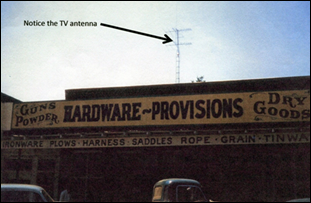
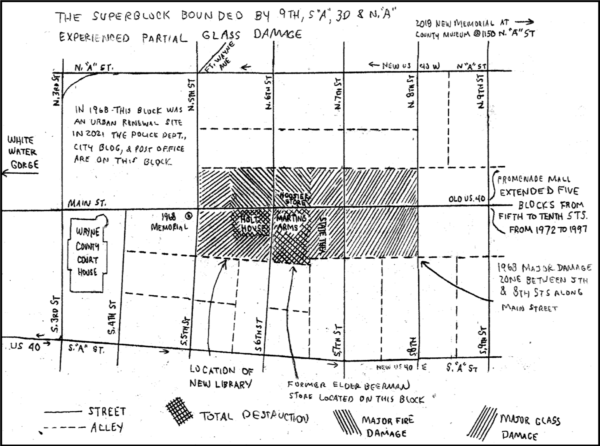
Upon further analysis the source of the explosion was determined to be at the corner of Sixth and Main Streets. Further investigations determined that ground zero was at the Marting Arms, a sporting goods store, located at the southeast corner of that intersection. Main Street was the route of the National Road through the city. Witnesses had related there was a heavy smell of natural gas a number of days before the explosion. Some witnesses claimed that two explosions had taken place, occurring in rapid succession, with the second explosion being the more destructive of the two. After the two large explosions a number of smaller ones followed. The scope of the damage was massive. On the two blocks at Sixth and Main Streets south of the intersection, about a quarter of the buildings were totally destroyed. Most of the remaining buildings on those two blocks were so severely damaged that they had to be torn down.
In total 15 buildings were totally destroyed; 20 buildings were condemned and many needed to be torn down later; and 120 buildings were damaged. Glass windows in buildings were shattered for three blocks in all directions. Forty one people died in the explosions and more than 150 were injured. Despite the carnage, things could have been much worse. At the time of the explosion the State Theatre, located in the same block as Marting Arms, was running a well-attended children’s matinee. Everyone was able to escape from the theatre building.
The Explosion Sequence
The nature of the disaster was such that events probably can never be determined with absolute certainty. What is known is that there were two major explosions, which took place in rapid succession. It has been estimated they took place two seconds apart. The first explosion was large, and it blew windows inward at Marting Arms, but it was the second explosion at the Marting Arms location that leveled buildings and caused the fires. A large amount of improperly stored gunpowder in the basement of Marting Arms was ignited in the second explosion and caused the majority of the damage. What caused the ignition in the basement has never positively been determined. After the original detonations, there were a number of smaller explosions, which resulted from leaks and sparks caused by the original impacts. Many victims drove themselves to Reid Memorial Hospital, located just north of downtown on Chester Boulevard (US 27) where it intersects with the Hodgin (Gorge) Parkway. As the afternoon progressed the halls of the hospital became crowded with those injured by the explosion and those inquiring about the fate of their loved ones.
The Gas Company
The President of the Richmond Gas Company was originally quoted at the time stating “I don’t know how it could have been gas,” claiming there had been only two gas leaks in the area since January 1st of 1968. Subsequent investigation determined that the first explosion was likely the result of a gas leak from a very old corroded cast iron pipe that exploded outside the sporting goods store, which was followed by an explosion inside the store. The gas odor noted in the area had become so bad in the days before the explosion that local stores were opening their doors to ventilate the fumes from their buildings. The U.S. Bureau of Mines found that the gas company had found fifty-five leaks in the area before the incident, of which seven were large and hazardous. A damaged perforated gas pipe next to the sporting goods store was removed by the gas company during the cleanup. The company refused to make the pipe available for examination by the authorized inspectors, and it was necessary to have the Indiana Public Service Commission order the gas company to turn over the pipe. Subsequent to the disaster more leaks were found throughout the city.
Three hundred ninety seven lawsuits were filed against the gas company, the City of Richmond and Marting Arms. Only one made it to trial; which was held in Connersville, Indiana pursuant to a change of venue motion. The gas company was found solely liable and a judgment of $250,000 was rendered. On appeal, the gas company lost. The remaining lawsuits were then settled by the gas company. The amounts of the settlement have never been disclosed but have been estimated to be between five to ten million dollars.
The Richmond Gas Company was founded in 1941 when local organizers obtained a regular gas supply from the Panhandle and Eastern Gas Company. Previously, beginning in 1854, as many as six separate companies had supplied either natural gas or artificial gas to the city. The Richmond Gas Company subsequently became a part of Indiana Energy in 1990, which became a part of Vectren Corp. in 2000. Center Point Energy acquired Vectren in 2019.
In response to the disaster, the 1968 Natural Gas Pipeline Safety Act, Public Law 90-481, was enacted on August 12, 1968. It imposed stricter federal regulation of the gas supply system in the United States.
Marting Arms
Marting Arms was a multigenerational family sporting goods business located in downtown Richmond at Sixth and Main Streets. Being ground zero, the explosion totally destroyed the building in which the store was located. The two members of the family running the business at that time, Donald (age 39) and Louise (age 36) were killed in the explosion. The business never resumed after the event.
“The Promenade”
At the time of the explosion there had been an urban renewal program in place which was clearing the area surrounding the Wayne county court house. A government center, including buildings for the city, police department, county annex, post office and library were planned for the area west of Fifth and Main. The explosion resulted in the expansion of the urban renewal area eastward to include the next blocks and the development of an urban mall along Main Street. Some buildings damaged in the blast, mostly on the north side of Main Street, were repaired or restored and remain in use today.
One of the first changes after the disaster resulted in the rerouting of US 40. The westbound lanes were moved to North A Street, and the eastbound lanes to South A Street. Both of these streets were designated one way in their respective directions. This routing arrangement has continued to the present time. The city administration then modified Main Street into an urban mall. They succeeded in obtaining a three-story Elder-Beerman department store to serve as the western anchor of the new shopping area. This was built on the old site of Marting Arms, and extended on the block to include the site of the State Theatre. The theatre was ultimately razed as its western wall was heavily damaged by the blast. Elder-Beerman declined to include windows in their building in order to minimize damage in case there was civil unrest. Five blocks of the street were closed and were replaced with a mall-like experience similar to those that could be found in suburban shopping centers. The new development opened in 1972. At the time these downtown malls were fairly common in many cities in the United States and Canada. Many facades of the older buildings in downtown Richmond were “modernized” with metal or glass panels. The final result was “The Promenade.” The former street area was decorated with seating, fountains, landscaping and other decorative elements. Parking was available in lots located behind the store fronts. At the time Richmond won a number of architectural and design awards for its city center mall.
At first the downtown shopping area was fairly successful. Over time, however, the business slowly declined and gravitated toward suburban locations. Finally in 1999 “The Promenade” was officially closed and the street was restored. The Elder-Beerman store remained open until August of 2018 when its parent company, Bon Ton Stores, went bankrupt and liquidated all of its stores and those of its subsidiaries. The Richmond store is currently vacant. Though it still has many empty storefronts, investment in the downtown area has slowly been increasing in recent years.
Memorials
Two memorials commemorating this unfortunate event have been erected over the years. The first was erected at Fifth and Main on the grounds of the Wayne county court house annex, one block from ground zero. This monument was erected shortly after the event. It is a simple curved brick tablet containing an inscription commemorating those who died and those who assisted the city in its time of need. To mark the fiftieth anniversary of the disaster in 2018 a new stone memorial was erected on the grounds of the Wayne County Historical Museum at Jack Elstro Plaza. That monument is entitled “Death on a Sunny Street—April 6, 1998—In Memoriam,” and includes all of the names of those who died that day in the explosion.
Bibliography
- Martin Beamer, Gas Explosion in Richmond, Indiana, April 1968, GenDisasters.com, 2021.
- Doug Masson, Indiana Bicentennial 11.10: The Richmond Explosion, April 6, 1968, A Citizen’s Guide to Indiana, Masson’s Blog November 2016.
- Connor Necessary; The Richmond Explosion; 50 years after the Tragedy, The Register.com, 4-6-2018.
- Kenjo Oshiro, Rehabilitation of a Central Business District: The Richmond Promenade, 1976 J-Global.
- Pal Item, I Thought We Were Being Bombed, Accounts of the Richmond Explosion and the Aftermath, Richmond Palladium Item April 4, 2018.
- VisitRichmond.org, Remembering the Explosion that Rocked Richmond: A 50 year Anniversary, Richmond Chamber of Commerce, April 2, 2018.
- WayNet, Historic Architecture Downtown Richmond: A Walking Tour, WayNet, Inc. March 2010.
- Whitewater Gorge Park Committee, History of Whitewater Gorge, 1983 Richmond Chamber of Commerce.
- Wikipedia, Richmond, Indiana Explosion, Wikimedia Foundation 2021.
- Russell Zimmerman, Richmond, Indiana: The Explosion of 1968, Clemson School of Architecture, February 27, 2019.
- Esther Kellner, Compiler; Death on a Sunny Street; 50 Years Later, InfinitiPrint Solutions, Richmond, Second Printing 2018.
Steam Tried To Move Canal Boats
By Carolyn Schmidt
As canals were receiving more and more competition from the railroads in the late 1850s and 60s, attempts were made to increase their speed and have the ability to move more boats with only once source of motive power. They came up with ideas to either power the boats by stream engines built into them or pull them using steam (later electric) mules on the towpath. New York seemed to have some success using steam on the larger Erie Canal. Therefore, Indiana, which had always used the Erie Canal as her standard, experimented with using steam power as did Ohio. At first it seemed promising.
Newspapers at that time carried articles praising those who experimented with steam:
—-
Fort Wayne Times & People’s Press
Jan. 23, 1850
Canal Steam Packet. — We are happy to learn that Mr. Doyle’s experiment of substituting steam for horse power on the packets on our [Wabash & Erie] canal is likely to be crowned with complete success. By a letter from Mr. Noble, the packet agent, we learn that the steam packet NIAGARA has been entirely remodeled having the boiler placed in the bow, and steam pipes running from bow to stern. Experimental trips have been made with her since the alteration, and she is found fully to answer or rather exceed the most sanguine expectations, making with ease 8 or 9 miles an hour. Mr. Doyle, the enterprising owner of the packet line, has been at much expense in this matter, and we congratulate him on the success which is likely to crown his efforts.
We find the foregoing in the Sentinel of last Saturday, and sincerely hope that the information conveyed by it may be correct. R. Doyle deserves complete success in his enterprise, and it is a source of congratulation on all hands if he has attained it.
—-
Ft. Wayne News-Sentinel
June 13, 1850
From Toledo Republican
Mr. Doyle and the extension of his Packet Lines. — Mr. Doyle the proprietor of the splendid and extensive lines of Packets on the Wabash [and Erie] and Miami [and Erie] Canals is now in our city. He informs us that he intended to proceed at once to Terre Haute, and establish a Daily Line of Packets between that place and Lafayette. This will add one hundred miles more to the already extensive lines of Packets now terminating at Toledo. — The packet line will then extend over five hundred and eighty-four miles of canal, employing fifteen first class canal packets and three hundred and fifty horses. The lines through their whole length, are in the most complete order. — It may be mentioned as an evidence of this remarkable discipline and energy, which Mr. Doyle has introduced into the management of his Packet business, that notwithstanding the great distance traversed daily by his Packets, that they arrive and depart from this port, with unvarying regularity. We are informed that no irregularity or detention has occurred in the time of arriving and departing, except when the canal has been out of repair. Last season, when the cholera unhinged all other kinds of business, the Packets did not miss a trip. Mr. Doyle’s energetic spirit overcame all obstacles and though he ran his boats with but few passengers, and for months, at a heavy loss, yet they were kept up, on the whole line with their accustomed regularity.
We also learn that Mr. Doyle has put his steam canal packet NIAGARA, on the artificial Lake or reservoir between Salina and St. Mary’s [Ohio], where she makes daily trips, connecting with the main line. The Lake [Grand Lake St. Mary], though an artificial one, has become one of the most beautiful in the country. It is 14 miles in length, covering an area of 17,000 acres. The NIAGARA is a beautiful craft, and she runs 7 miles an hour on the Lake.
No town in the United States has an equal extant of Canal Packet travel with Toledo. Mr. Doyle is doubtless the most extensive Packet proprietor in the Union. — he is a perfect Napoleon in this line. — Tol. Rep.
—-
The 1859 Message and Reports made to the General Assembly and Governor of the State of Ohio For the Year 1858. Columbus, OH: Richard Nevins, State Printer, 1859. included the following on “Steam Propellers” advocating making Ohio and Indiana’s canals larger for steam propelled canal boats:
“The demands made upon those having in charge the canals of the various States, except where the railroad companies have purchased the interest of the States, have been of that character that required every exertion to be put forth in order to increase the ability of those who had large amounts invested in canal stock to enter into successful competition with the railroad lines for the surplus property of the country seeking an eastern market.
“The facility that has been offered by the railroads, for passing property from the extreme west to the eastern market, has induced shippers to avail themselves of this mode of conveyance in many instances, in order to meet the high ruling prices of the week, or the maturing paper of the owner of the produce, at prices far above the cost of transporting the same property by a cheaper and less dangerous channels of water communication. Over the greatest and most important canal route in the United States (the Erie Canal), the demand has been promptly met by the enterprising Canal Board of the State of New York, by the introduction of canal boats with steam propelling machinery attached, capable of carrying two hundred and fifty tons; receiving the freight at Lake ports and delivering it without transshipment, and the usual loss attending its conveyance by rail, at New York, within a time that will eventually secure to this all important canal the entire surplus produce of the North Western States seeking a market at the sea board during the season of canal navigation.
“The ability of one of these steam canal propellers to thus receive their freight on the shores of lake Erie, and convey to New York thirty-one car loads, of eight tons each, within a time that will make but little difference to the owner, is of incalculable importance and pecuniary interest to the great producing agricultural classes of our Western States, none of which are so directly and deeply interested in this reduction in the cost of transportation, than the farming interest of our own State [Ohio], which is now and will be, increasing their surplus grain exports, yearly seeking an eastern market.
“The system has, so far, met with such unexpected success in the State of New York, that the present lifetime of the old fashioned, slow and expensive method of propelling canal boats by horse power must terminate with the present canal stock, and its place be supplied with boats propelled by steam, and capable of making double the speed, and carrying three times the amount of freight.
“The capacity of the Erie Canal, it is true, is almost double that of the Ohio [and Erie] canal from Portsmouth to Cleveland, and of the Miami and Erie [Canal], from Cincinnati to the Junction, in Paulding county; it being seven feet deep and seventy feet surface of water, with its embankments securely protected with stone slope walls, to guard against the injurious effects of the waves, produced by the high winds and the steam propeller.
“A portion of the line of canal reaching from Toledo to the fertile and productive valley of the Wabash, in Indiana, a distance of one hundred miles, could, with trifling expense, be so improved as to afford six feet of water, and be capable of carrying an amount of freight to each boat as would, it is believed, justify its transshipment at Fort Wayne, in Indiana, and at the same time be capable of conveying the great surplus of this portion of Indiana, drained by the Wabash [and Erie] canal, as against all successful railroad competition at a price that would be alike productive to the interests of the two States and the producer.
“The other canal lines of our State have a depth of four feet, and a surface of forty feet, capable, without incurring very great expense, when compared to the benefit to be derived by the State and the farming interest, of being raised to five feet in depth of water. Experience must settle the question whether the enterprising spirits that have set in successful operation the steam propellers in seven feet water on the Erie Canal can, with like success, so construct boats, as to be able to navigate, with proportionate gain, in five and six feet water.
“The Board would feel quite willing to extend to the owners thus engaged in the experiment all the special privileges granted by the Canal Board of New York to those who introduced steam power on the Erie Canal.
“ALEXANDER G. CONOVER,
JOHN WADDLE,
ABNER L. BACKUS.”
—-
With this type of encouragement from the Ohio government, Ohio and Indiana continued to experiment with steam power. Newspapers that year reported:
Indianapolis Gazette
May 21, 18?9 [1859]
Canal Steam Boat.—On Thursday last, says the Dayton Journal of April 21, the steam packet ENTERPRIZE arrived at this place [Dayton]. Several attempts have heretofore been made to navigate canals by steam boats, which have generally failed from various causes but principally on account of the injury done to the banks by the commotion produced in the water. The ENTERPRIZE has been constructed with a view to avoid this objection and in this respect the experiment has completely succeeded. Two narrow boats are placed side by side, with a space of about four feet between them having one bow which is so constructed as to allow the water to pass into the space between the two boats without obstruction. The furnace and boiler are placed in the forepart, exactly over the space between the two boats so that the coals passing through the grates fall immediately into the water. The paddle wheel is directly behind the boiler, between the boats and the piston, cylinder and crank are on one side and the fly wheel on the other. The water after being acted upon by the paddle wheel, which is rather forward of the middle of the boat, passes out to the shore between the boats, and being thus confined and smoothed before it is cleared of the stern, no waves of any considerable size are formed. The agitation of the water, when the boat was going at the rate of four miles an hour, was less than that caused by a horse [pulled] boat going with much less speed. From the paddle wheel to the stern, a platform is laid over both boats and the space between them forming the floor of the cabin which contains twenty-seven berths.
On account of the lowness of the bridges, it is necessary that the chimney should not be higher than the roof of the boat. An ingenious machine is placed in it for the purpose of creating a draft being a kind of a windmill running so as to draw the air out of the chimney, and turned by a band from a wheel attached to the machinery. Two cords of wood were expended in the passage from Cincinnati to Dayton.
—-
Dawson’s Daily Times
September 10, 1859
Steam on the Canal.—The Columbus State Journal says: The canal steamer ENTERPRIZE has again arrived with 1,700 bushels of coal. This novel method of navigating the canals improve every trip, and can hardly fail to work a revolution in canal management, making them a paying instead of losing property.
—-
Huntington Herald
May 29, 1862
A steam canal boat passed through this place last Thursday. Its size is that of an ordinary canal boat, and its engine is near the stern, which propels a screw rigged near the rudder. We learn from the Toledo Commercial that she made the trip from Lafayette to Toledo, a distance of 220 miles, in five days, which is a gain of two days over the usual means of propelling. The fuel for the trip from Lafayette cost $13.87, while the expense of towing would be over $30. The boat is said to be a perfect success.
—-
Fort Wayne Weekly Sentinel
July 5, 1862
Steam on the Canal. — If any doubts have been entertained as to the practicability of navigating the Wabash & Erie Canal in this State with steam canal boats, they could have been easily removed by seeing the ease and speed with which Capt. Sabin, of the canal boat “UNION,” with 1713 bushels of corn on board, towing the “WATERMAN,” with 1911 bushels of wheat, and the “MATILDA,” with 1805 bushels of corn passed through the canal. These boats were all loaded at Perrysville in this State 182 miles from the State line, and bound for Toledo.
Last winter, Captain Sabin placed in the “UNION” one of the Welch, Ireland & Corb (of Chillicothe, Ohio) canal boat engines and propellers, and with this boat loaded as above stated and towing the other boats, has made as good time as can be made with a single boat with the same load by a team of mules or horses. He loses some little time passing locks with his three boats, but makes its up by an increased speed on long levels. In the wide and deeper canal from here to Toledo, he can make better time and carry much larger loads. He would have taken from here this morning 200 barrels of flour in addition if he could have obtained it. Captain Sabin has made several trips and has given assurance in saving time and making money, that steam on the canal is no longer a theory but a perfect success. The UNION was an old canal boat and of course not constructed with a proper regard to use for an engine and propeller, but with all the disadvantages she has convinced the doubting that the Indiana canal is large enough and deep enough for profitable steam navigation. Important changes and results in canal navigation must ensue from the use of these engines and propellers.
—-
Indiana Herald
October 1, 1862
From Toldeo Blade
The canal propeller “BUFFALO” arrived here yesterday from Huntington, Indiana, with a full load of Wheat and Flour. The B is a new boat, now on her first trip, and is represented as fulfilling, in every respect, the anticipations of her builders, and owner, Captain Morgan. She left Huntington Thursday morning, and arrived here at 5½ P.M. yesterday making the run 129 miles, in 72 hours, from which should be deducted 5 hours’ detention at Fort Wayne and 1 hour at Providence [Ohio]. The captain made no effort to crowd the boat, the machinery being rough and a large fleet coming in, which he was not allowed to pass. The engineer of the boat informs us that one cord of wood is amply sufficient for 24 hours’ run, demonstrating that so far as economy is concerned, that has been secured, in its fullest extent, by the introduction of steam as a motive power on our canals.
—-
Dawson’s Daily Times & Union
May 2, 1863
The Canal Boat, JOHN GOOD. — In company with some twenty invited gentlemen, we took passage onboard the recently completed STEAM CANAL BOAT, JOHN GOOD, which left her moorings near Comparet’s warehouse [Ft. Wayne] for a short trial-trip, yesterday at about 12 M. The trip proved her an entire success, and her performance far exceeded the expectations of her builders and owners. Steam navigation on our canal is still in its infancy and heretofore has been nothing more than an experiment; but the JOHN GOOD demonstrates the possibility of navigating canals with steam, and commences a new era in the history of our public improvements. Every person on board was highly delighted with the trip, and the builders and owners have cause to be proud at the success of their achievement.
The JOHN GOOD was built at Roanoke by Capt. Vanbecker; her machinery was made at the Fort Wayne Machine Works, by W. T. McKean, Esq.. She is intended to run between Palestine, Ill., and Toledo, Ohio. She made six miles per hour on her trial trip but will far exceed that when loaded down. She carried 2,200 bushels of wheat, making 71 tons and takes in tow another of equal capacity.
—-
Fort Wayne Weekly Sentinel
June 13, 1863
Steam Canal Boats. — On the Scioto Gazette on the 2nd inst., we find a lengthy article on the subject of Steam Canal Boats, in which special notice is made of different experiments on the Wabash [& Erie] Canal, and of the steamers now in use. The machinery for nearly all of the steamers on our canals was constructed by Messrs. Welsh, Ireland & Co., Chillicothe, [Ohio], but the increase in boats is so great that this firm are unable to fill orders, and machinery of other manufactories is being used. This will create a spirit of rivalry among machinists, and we may expect that the improvements of the next year will be of a character to almost banish horses and mules from the towpath. The latter method propelling is expensive, while the speed attained will average only about one-half as great as that by steam for a single boat, while one steamer is capable of towing two or three boats, and then making better time than a horse boat.
We are glad to note the success of steam on our canals, but are confident great improvements will be introduced within the next few months which will demonstrate to a still greater extent, the advantages of steam as a motive power on the canal.
—-
Wabash Express
August 26, 1863
The Fort Wayne Gazette is happy over the appearance of steamers on the canal at that place. One came down from Toledo a few days ago, towing a raft of logs. Steamers for canals may, one of these days, restore the old advantages of artificial water communication, and pay back railroads the injury they have so long been suffering.
—-
Ft. Wayne Daily Sentinel
Sat. July 20, 1872
Steam on the Canal. [Steam mule on towpath] — And now it is said that we are to have steam canal boats. A new invention was tried on the 16th inst., in New York, and the result is described by the Troy Times as having been of a highly satisfactory nature.
We learn, from the Toledo Commercial, that — In general appearance, the steamer resembles a three-wheeled velocipede. Two men are required to manage it—one acting as fireman and engineer, and the other as pilot and steersman. The former stands behind, and the latter sits in front. The hind, or driving wheels are about four-and-a-half feet in diameter, and the forward one about three feet. The face, or tread of the wheels, measure about ten inches, and resembles cogs; the pieces of iron placed transversely preventing the wheels from slipping in wet weather and giving them a firmer hold when the ground is dry. It runs on the tow-path and is attached to the boat by a line in the same way that horses now are. Some doubts were felt in regard to the ability of the machine to run up steep inclines, such as are frequently encountered at the ends of bridges; but these misgivings were all dispelled on Tuesday, as it ran up a very steep grade, and turned around on a bridge at the top in a space not exceeding its own length.
We understand this morning that the manager of the Wabash and Erie Canal will give the steamer a trial, and that if it comes up to their expectation, they will adopt it in place of their present method of transportation. The improvement would greatly benefit the Canal; and restore to it all the popularity which it formerly possessed. It would also contribute to the growth and improvement of our city nearly, if not altogether, as much as the introduction of a new Railroad.
—-
No mention has been found of the steam powered mule, which is mentioned in the above newspaper article, ever being used thereafter in Indiana nor the steam powered canal boat ever being proved to be successful over time. The steam propelled boats, with their increased speed, washed out the canal’s banks. Experiments showed that they needed at last a 6-7 foot depth for steam propellers to work efficiently. Greater depth required more water. It had always been a problem to provide enough water to fill the original 4 foot depth required to float canal boats. (A fully loaded canal boat had a draft of 2½ to 3 feet allowing a clearance of about a foot.) By the 1850s-60s canal structures were failing; reservoirs were being blown up; banks were eroding due to freshets and rodents; and the canal prism was filled with silt in some places. Grass that grew in the canal had to be cut or it would choke the propellers. The canal were no longer owned by the state. It had been turned over to a trust in 1847. The revenues were not sufficient for the Trust to maintain the structures or the prism let alone increase the size of the canal and the need for additional water. The canal operated seasonally and could not compete with the newer technology. Taking into consideration all of these problems, Indiana didn’t enlarge the Wabash & Erie Canal from Fort Wayne to Junction, Ohio, to accommodate steam boats.
However, Ohio was still hopeful. On May 19, 1874, an article that was found in the Cleveland Newspaper Digest Jan. 1 to Dec. 31, 1874. says: “Canal navigation by steam will yet be made a practical success. Let New York prove the entire success of this experiment and canal navigation will soon be revolutionized.”
In the following article, Terry Woods, Past President of the American Canal Society and the Canal Society of Ohio, and a CSI member, reviews the use of steam on the Ohio and Erie Canal.
STEAM ON THE OHIO CANAL
[The ENTERPRISE mentioned in this article is different from the ENTERPRIZE in the above article.]
By Terry K. Woods
In the very early days of the canal-era in Ohio, steam engines were built in many of the larger canal towns by local mechanics, but the vast majority were crudely designed and constructed, very heavy, and impractical for the use of propelling canal boats.
One Ohio Canal town firm, however, earned a considerable reputation as a builder of complete marine engines, specifically designed to power canal boats. This industry was the Chillicothe Foundry and Machine Works, founded by William Welsh along the banks of the Ohio Canal near Water and Mulberry Streets.
This firm, in its lifetime, constructed 50 or 60 canal boat engines. The machinery was described as “light” weighing only four to six tons, including boiler and “propelling wheel”. The Chillicothe “wheel” had a particularly good reputation in the “west” and was “much used.” The wheel design consisted of a cast iron hub, with three short and narrow arms. To these were riveted three wrought iron blades. The idea of attaching wrought iron blades was to allow them to be quickly detached and straightened or replaced should they have been accidently damaged. The engine was not always connected directly to the drive shaft, but drove the “propeller-wheel” by means of gearing.
While these canal boat engines performed well enough, the boats, themselves, did not. Owing to the shallow depth of the canal, and the heavy summer growth of canal grass in the channel, itself, any “propelling mechanism” had problems. In motion, the action of the “propelling wheel” drew water away from the after end of the boat and the stern would often drag along the bottom. With six feet of water in the channel, most agreed that these boats would have done well, but, by the season of 1881, they had all left the canal and gone into river service.1
We do have an insight into some of the operations of a steam canal boat that ran on the Ohio Canal and a number of it’s branches shortly before the Civil War. This craft, the ENTERPRISE, was, reportedly, built at the Payne & Wood Boat Yard in Peninsula in 1859 for a Capt. Deuel from Franklin Mills (Kent), Ohio. As built, the craft was a 60 ton freight boat of standard design with a square stern. Her engine, is reported to have been built at Cuyahoga Falls and had a 7” bore, a 12” stroke, and produced eight horsepower. The ENTERPRISE was propelled through the water by twin “wheel propellers,” one mounted on each side of the tiller, below the “bucking wale.” Originally each of these “wheels” carried four paddles or buckets. But they churned the water up so badly that the design was changed to three and this seemed to be the “normal” for canal boat propellers from then on.
The ENTERPRISE had her engine and drive train installed before being launched. Subsequent steam canal boats launched from the Peninsula yards found it more efficient to install the engine and drive equipment after the boat was in the water.
Five or six similar steam canal boats were launched from the Peninsula yards. The second craft built by Payne & Wood, the GREY EAGLE, for Capt. Bryant of Dresden, also had a square stern. The Peninsula boat yard of Johnson & Boughton built round sterned steamers. No better “sailing” characteristics were claimed for either design.2
In June and July 1859, several newspapers along the line of the Ohio Canal and Muskingum Improvement told of the Canal Steamer ENTERPRISE’s departure from Cleveland on June 18th to travel to Zanesville. She was loaded with fifty tons of iron ore.
Though she attracted stellar crowds along the way as she ventured along, the reports of her progress were not stellar. It was hoped that steam towing could be “profitably used” in towing canal boats and a greater average speed could be achieved than with horses or mules. And though the ENTERPRISE was capable of speeds up to 5 or 6 miles an hour, her daily travels (she “put up” at night) were sometimes restricted to as few as sixteen miles. Though knives had been attached to her hull in an attempt to “cut” the canal grass before it became entangled in the propellers, this scheme was unsuccessful and periodic stops to clear the “driving equipment” were required along their journey, which required most of nine days!
Shortly after arriving at Zanesville on the 27th and unloading her cargo, the ENTERPRISE set “sail” for the village of Walhonding, far up along the Walhonding Canal in Coshocton County with a cargo of coal for the “Oil Works” of Messrs. Brooks & Graves.
The next public record of the ENTERPRISE that has been discovered to date is its participation in the 4th of July celebration in Franklin Mills. In addition to Military Bands, 13 and 33 gun salutes from two militia groups, a “Majestic Fire Works Display,” and several “Balloon Ascensions,” Capt. Deuel and the STEAM CANAL BOAT ENTERPRISE were scheduled to provide excursions to Ravenna, Cuyahoga Falls, and several other communities along the Pennsylvania & Ohio Canal.3
We again hear of the ENTERPRISE in late August of 1859 when she arrived at Columbus, Ohio at the head of the Columbus Feeder Canal, carrying 1,790 bushels of Slack Coal. Thousands of people gathered along the banks of the Feeder and at the Guard Lock in Columbus to gaze at the this novel craft. Later, Capt. Deuel offered rides on the Scioto River past the State Penitentiary upon this steam-powered canal boat – for ten cents a head!4
As late as the boating season of 1861, the ENTERPRISE was recorded when entering the Port of Cleveland with a load of flour from Chillicothe. After that, though, she seems to have disappeared from the pages of recorded history. There is, however, a “For Sale” advertisement that could prove interesting, – – “Canal boat ENTERPRISE suitable for photograph gallery, excursion, trading, or showboat, enquire on board – Sixth st. and Canal.” The facts that this advertisement was from the Dayton Herald (on the Miami & Erie Canal in the western part of the State) and was in the July 7th, 1891 issue of the paper, diminishes the chances that this is a reference to “our” canal boat ENTERPRISE – – – – still, who knows? 5
—————
1Much of this information came from an article, POWER ON THE TOWPATH II TOWPATHS, Issue No.
4, 1964, Lew Richardson, pgs. 4 & 5.
2Ibid and research information obtained from Randy Bergdorf, of the Peninsula Historical Society.
3From research information supplied by David Meyer of Canal Winchester.
4Ibid & Jon Baker, New Philadelphia TIMES-HERALD, June 8, 2020.
5David Meyer.
Indiana’s Old & New Central Canal and Transportation Symposium
On August 28, 2021 the Canal Society of Indiana met in the Chief Anderson room of the Anderson Public Library in Anderson, Indiana for a symposium on early transportation in Indiana. There were 36 people in attendance. They were:
CSI Members (21)
Carl/Barbara Bauer, Tom/Linda Castaldi, Gary/Cassandra Ferris, Sue Jesse, Jeff Koehler, Jerry/Phyllis Mattheis, Dr. Ron Morris, Mike Morthorst, Andrew Olson III, Andy Rebman, Bob/Carolyn Schmidt, Neil/Diana Sowards, Frank Timmers, Dan & Ceri White
Guests (15)
Judy Arnold, Craig Berndt, Jackie Dale, Ron Darrah, Kathanne Fields, Daisy Gabbert, Bob Gray, Melinda Henry, Emilee Isenhour, Stephen Jackson, Becky Monroe, Karen Napier, Dick Nottingham, and two late comers
After a brief welcome by CSI president, Bob Schmidt, PowerPoint Presentations were made. Stephen Jackson, Madison County Historian and author of If The River Could Talk, What’s In A Name, and Historic Events In 19th Century Madison County, was the first to present a program entitled “The Central Canal” and later presented one on “The Anderson Hydraulic.”
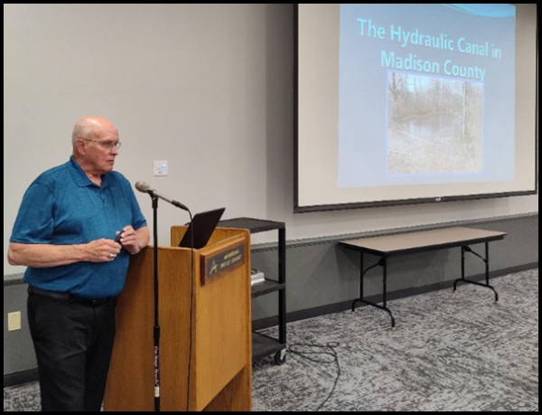
Stephen said that the Central Canal was originally planned to be 284 miles long. Forty-five of these miles were under contract between 1836-37 with 87 different contractors. However, only 41 miles of the planned 75 miles were completed. Although it never operated in Madison county, remains of its route can be found at the following locations:
Between 800—600 N E of State Rd. 9
South of Rangeline Rd. and South East 10th St.
800 NE of State Rd. 9
700 NE of State Rd. 9
600 NE of State Rd. 9 (now a county drainage ditch)
5600 Alexandria Pike (in a backyard by Little Kill Buck Creek above 500 N at Prosperity Lake)
4451 N 100 E (Dale Cook uses the canal bed to travel back and forth on his property. Only a towing path was needed to be built.) See Hoosier Packet July 2010.
Canal prism ends at 400 N. Only 4 miles of the Central Canal are left in Madison county.
McCullock Farm, Scatterfield & Cross St., canal empties into White River at Anderson Pike & Alexandria
Western Hills—Moss Island & River Forest (The Moss Island Mill built in 1836 burned and was rebuilt in 1875. It used canal water for power. Joseph Muellirex could put his products on canal boats.)
Behind Western Hills —140 ft. of canal remains
Behind River Forest— 140 ft. of canal remains
8162 West 8th St. Road—Cunningham’s have watered canal (On property right there is a spur of canal off the main canal as it goes towards White river.)
Central Canal Feeder Dam Branch from Anderson to Muncie (The feeder canal appears to be below the route of the Hydraulic Canal. There are about 100 yards of canal to connect Muncie town to Andersontown.)
About 9 miles of the Central Canal were completed through Indianapolis to Broad Ripple. The canal was sold in 1851 for $2,435. In 1871 all that was left in Indianapolis was purchased by the Indianapolis water works for $200,000.
Stephen then listed all the communities that arose following the announcement of plans for the Central Canal and said the population at Anderson doubled from 150 to 300 persons.
1836 Hamilton
1836 Alexandria
1838 Pittsborough/Prosperity
1838 Victoria
1839 Mt. Pleasant
1839 Rockport
The canal brought about the establishment of the Irish Tavern by Ferriter and the area became known as “Scabby Hollow.” A confrontation between the Orangemen and the Irish Catholics took place there. The tavern served as a church on Sunday and was the beginning of St. Mary’s church.
Following a question and answer period attendees broke out their brown bag lunches and ate nutrition bars donated by Ellison Bakeries. As they were finishing their meal, Bob Schmidt gave a presentation about the Canal Society of Indiana, its goals and projects. Door prizes were drawn.
Andrew Olson III then presented a PowerPoint program entitled “Transportation and the End of the Pioneer Era.” Andy has been a member of CSI for many years. He wrote an article about his ancestor David Kilgore and the part Kilgore played in Indiana’s canals, which can be found under biographies on the CSI webpage (Hoosier Packet October 2015). Andy’s interest in early Indiana transportation led him to write Forging the Bee Line Railroad, 1848-1889—the Rise and Fall of the Hoosier Partisans and Cleveland Clique in 2017.
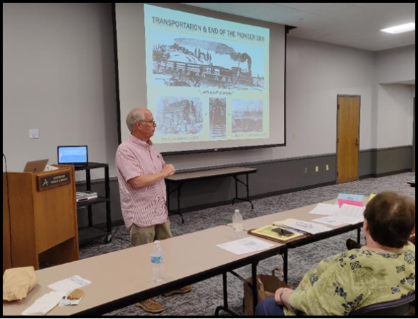
After the American Revolution and western expansion began, there was the necessity to link the coastal states with the interior, today’s Midwest. The distances involved demanded more than the dirt roads and animal transportation used at that time. There was concern that if transportation routes weren’t linked, the western portion might break away or align with the Spanish in New Orleans.
In 1808 Albert Gallatin, Secretary of the Treasury in the Jefferson administration proposed a system of roads and canals to link the nation together. He was ahead of his time, but thereafter the Cumberland or National Road was begun in 1811 and proceeded by 1837 thru Ohio, Indiana and into Illinois. However, Federal funding ran out and the states were given responsibility to maintain the roadway.
Steam was first used by steamboats to propel a vessel against the current of inland rivers. By the 1830s the nation’s rivers were filled with these dangerous boats used for both commercial and passenger traffic. The southern portion of Indiana became linked via steamboats on the Ohio and Mississippi rivers to trading with the south, all the way to New Orleans.
By the late 1820s steam had also been applied to cars on rails. The steam engine was capable of pulling a couple of carriages (cars) along at about 15 miles per hour. However, it looked nothing like the engines of today. It was more like a pot bellied stove on a flatbed car.
Earlier in 1817-1825 New York had built the Erie Canal across the state from Albany to Buffalo. It was an immediate success and stimulated canals all across the Midwest. Around 1836 Indiana wanted to build canals throughout the state. The National Road had just about been completed from Richmond to Terre Haute. Indiana Governor Ray thought the legislature should give serious consideration to railroads, but the canal lobby could not be stopped. Rails and engines had to be imported from England whereas Hoosiers, with the help of imported Irish laborers, could build canals by using local stone and lumber, thus keeping the money expended within the United States. Canals were operational before railroad technologies were developed. Also at that time canals were thought to be more permanent.
Andy gave some history of Thomas Morris, Calvin Fletcher, and Andy’s ancestor David Kilgore. All of these men were instrumental in promoting railroads in Indiana. Earlier Kilgore had promoted canals.
Up until 1840 all railroad engines came from England, however the technology of railroads improved in the United States. It developed the pony-truck wheels in front and a suspension system to aid in going around curves. By the 1850s many railroads were being constructed throughout Indiana in short independent lines with different widths between the rails some at 4’10” (Ohio gauge) and others at 4’8”. It wasn’t until the 1850s that the standard gauge became 4 feet 8½ inches in the northern states. During the Civil war most of the southern states had problems transporting troops and supplies by rail due to the differences in gauges.
Canals at first faced a similar problem with different lengths of locks. George McClellan discovered this at Harpers Ferry in 1862 when a canal boat would not fit into a lock.
Early railroad terminals were independent of each other. Passengers would have to get off a train, take other transportation to the next depot, and get on another train to continue their journey. Remember President elect Lincoln in 1861 had to transfer between rail lines in Baltimore on his way to Washington, exposing himself to potential danger. On September 28, 1853 Indiana solved this problem with the erection of the first Union Station in the nation at Indianapolis. The rail lines met at the station and passengers could easily change trains.
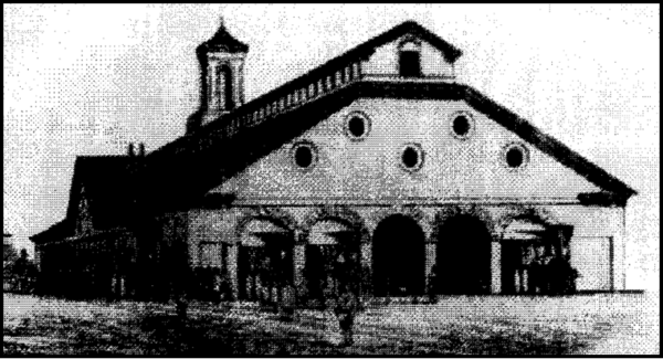
Eventually the railroads standardized their gauges and coordinated their schedules. Many of them merged—such as the Big Four. Andy showed how the Indianapolis and Belfontaine Railroad became the Bee Line Railroad. This was a straight line from Indianapolis to Cleveland. It was created over a period of time and overcame the gauge problem between Ohio’s and Indiana’s rails.
From roads to canals to steamboats to rails, the nation continued to expand its transportation network. This linkage of the northern states is what held the Union together during the Civil War. These states were economically dependent on each other.
Andy’s program showed how this transportation transition occurred. At the conclusion of his program he also described how standard time was the result of the railroads needing a accurate time schedule on a regional vs. a local basis.
He said the “Pioneer Era” ended with the coming of portable transportation. It changed the life and culture for people throughout Indiana and the nation.
After a short recess, drawings were made for more door prizes.
Our symposium concluded with Stephen Jackson tracing the route of the Anderson Hydraulic throughout Madison County. This 8-mile-long canal was not a transportation canal. It was strictly dug for water power as there was an elevation change of 44 feet from the White River near Daleville to downtown Anderson. Unfortunately on July 24, 1874 as soon as water was let into the prism of the canal, the banks quickly eroded due to the rapidity of flowing water without lockage. After two attempts $80,000 of capital was lost and the hydraulic canal was abandoned.
He showed good pictures of what remains of the Anderson Hydraulic at County Road 500 E where it crosses from Delaware county into Madison county and on Madison County Road 300 E between State Road 32 and Lindberg Road.
Stephen said that some property owners, through which the hydraulic once ran, are trying to purchase more land and create Redtail Land Conservancy Hidden Canal Preserve. It is wonderful to know that it is being saved.
After a question and answer period another drawing for various canal related books and materials was held and the meeting adjourned. The day ended about 3:30 p.m.. We returned to our homes with the feeling of a day well spent.
New Sign For Gateway Park
The Whitewater Canal Scenic Byway has placed two new signs back-to-back at the entrance to Gateway Park in Metamora, Indiana. Ron and Candy Yurcak hung them on September 4. They are near the Whitewater Canal Scenic Byway Visitors’ Pavillion and the old railroad depot.
New Executive Director For Delphi Canal Park
 Mike Tetrault has been selected to join the work of Wabash and Erie Canal, Inc. as its first Executive Director. A graduate of Butler University with degrees in media arts and education, he will combine his passion for learning and teaching with his creative drive as he has done in the past while working as a Peace Corps Volunteer in Madagascar.
He has worked in the classroom teaching French and Math. Recently he has mentored youth; created media and music; and organized, led and recruited teams of volunteers at Riverside Covenant Church in West Lafayette.
Mike has been a resident in Delphi for the past seven years. He is married to Autumn, also a teacher, who has a gift for design and photography. They have a daughter, Eloise.
Mike is looking forward to building upon the efforts of the incredible volunteer and staff members at Canal Park and working with the Wabash and Erie Canal Association.
Eagle Scout Project Replaces Trail Benches’ Seats And Backs
Josh Williams, a Boy Scout from Americus, Indiana, chose to replace the seats and backs of trail benches along Delphi’s trails for his Eagle Scout project. He planned for his Scout Troop to cut, sand and stain lumber to renew the benches at the end of September 2021. They used 2-inch-thick hardwood planks. The restored fifteen benches along the Van Scoy Towpath Trail and Obear Millrace Loop. For his and his troops work Josh was offered free space in the park’s conference room for his Court of Honor.


Canal Clippings From Old Newspapers
Indiana American, Brookville, Indiana
February 6, 1846
White Water Canal. This Canal has now been open about ten days. The boats, which have somewhat increased in number since last fall, are rapidly taking away our produce.
Indiana American, Brookville, Indiana
February 6, 1846
White Water Valley Canal Company.
The Connersville Telegraph gives the Report of the Company, which contains facts of some interest to this region. The contract of Mr. Vallette was completed, as our readers know, in July last. The navigation is now open to Cambridge City on the National road, the point to which it was originally proposed to carry it.
The principal items of account with the Company stands thus—Cin. Chron. Price Current.
Capital stock, $432,000
Cost of Construction, 423,000
Real Estate for Sale, 21,201
The water power of the Company is represented as very valuable; and as affording good reason to believe that it will be of vital importance to the interests of the Company.
The Tolls from the 1st of June to the 1st of December, was as follows:—
At Harrison, $3,450.90
“ Brookville, 2,537.18
“ Connersville, 2,521.47
“ Lawrenceburgh, 325.47
. $8,836.32 [Should be $8,835.02]
Water Rents, $2,236.28
Total Receipts 11,472.59
Expenses of Repairs, &C. 7,614.72
Of the Debts and Means, that account is:
Means $182,567.94
Liabilities, 176,974.44
This is exclusive of the Canal itself.
On this exhibit the Company passed the following orders:
Whereas, This is the day prescribed for the regular semi-annual declaration Dividends—and it being ascertained that the net profits of the Company at this time, after making the usual reservation for contingencies, making a Dividend Fund equal to Two and one Half per cent.
But inasmuch as said Fund is mostly composed of the Paper of the Company, and the balance is indispensable—unless a loan be resorted to—for the purpose of paying the February installment of Interest on the debt of the Company, created for Construction, Therefore
Ordered, That payment of said Dividends be surrendered, until means arise from payments of Stock in Cash, equivalent thereto, out of which the same may and will be promptly paid.
Provided however, that any debtor of the Company, owning any such Dividends, may have the same passed to his Credit on account, at any time, on request—or upon the order of any owner—the same may be applied to the liquidation of any of the company’s dues—not consistent with prior orders.
Indiana American, Brookville, Indiana
February 6, 1846
MOB AT PERU!—We understand that great excitement prevailed a few days since at Peru—that the People in large numbers had assembled—compelled the keeper of the Canal Land Office to resign—took possession of the Books of the Office—and thus put an end to the entry of Lands for the present.
This high-handed measure, we learn, is in consequence of the passage of a law on the last day of the late session, declaring lands upon which the interest had not been paid, forfeited to the State, and subject to immediate re-entry. This law was got up for the benefit of the speculators in Canal Scrip, and carried through the Legislature, as before remarked, at the very heel of the session—and before the news reached the settlers on the lands, these speculators, who were at the seat of Government at the moment, had posted off to Peru and commenced entering their farms and choice lands.
As much as we deprecate everything like mob violence—and we are of those who think that the laws should be sustained at all hazards—still, this sudden outburst of the settlers, under the peculiarly oppressive and irritating circumstances of the case, ought to be looked upon, we think, with some degree of charity.
Indiana American, Brookville, Indiana
February 6, 1846
THE FROG.
Of all the things that ever lived,
In woodland, marsh, or bog.
That creep the ground, or fly the air,
The funniest is the frog;
The Frog—the scientifickest
Of nature’s handiwork—
The frog, that neither walks nor runs,
But goes it with a jerk.