

- Covington Toll Records (Part 2)
- Structures On St. Joseph Feeder
- Peruvian Canals
- W & E Canal Bridge In Fort Wayne
- Canal Notes # 19: Appleseeds
- Reminiscences Of Canal Travel In 1851
- F. C. Brase Paid Toll for Boat at Covington
- 1839 Document To Lease Water From Central Canal For A Mill
- Great Time To View Canal Structures
- Whitewater Canal Byway Association Annual Meeting
- News From Delphi
- Memorial Day
Covington Toll Records (Part 2)
Bob Schmidt
In the March issue of The Tumble I, Bob Schmidt, reviewed one of the two types of toll records found at the Covington, Indiana Courthouse. This month, I want to review the second type of records that Lowell Griffin digitized during the 2020-21 pandemic. These records are for boats that were cleared and a toll paid at Covington. When they left their home port, Covington was the first toll station they reached. Here their bill of lading information and their toll was recorded in large book. I chose to analyze the 392 records for the year 1861. Canal activity was still quite heavy in that year as the country was in the midst of the Civil War.
Quite obvious at first glance, boat traffic is almost entirely coming from the south, proceeding north and largely heading for the Ohio state line. Boats are coming from Clinton, Perryville Side-cut, Montezuma, Sugar Creek and Howard. There were only a few boats coming from Attica and points further north as there were few towns of any size between Lafayette and Covington. There was very little traffic to Terre Haute since the canal was closed south of Worthington by 1861. Any boats returning to points south of Lafayette would have paid a toll at that station or earlier in Ft Wayne, etc. The Covington toll books only recorded shipping points north of Terre Haute and south of Covington. The bulk of these records show corn, wheat and coal being carried onboard. There were no packet boats listed, but any that remained by 1861 would have been based out of Terre Haute or Lafayette, not Covington. Of the 392 boats that paid a toll, most had to make a returning round trip for another 392 events. That would mean about 800 – 850 boats passing through Covington. April thru October = 214 shipping days. The average number of boats passing through Covington would be about 3-5 per day.
During 1861, many of the boats with the same name followed a similar path each trip. They left for the state line and returned again following the same route. Wheat and corn were shipped to the state line. Coal was usually shipped from Clinton to Lafayette, but never to the state line. The Ben Kline traveled pretty consistently between Clinton and Lafayette carrying coal The Rob Hull carried potter’s clay from Sugar Creek to Delphi. The J F Smith and the Aetna, routinely carried wheat or corn to the state line and then on to the port at Toledo. The Little Dixie ran a shuttle between Covington and Attica, sometimes empty, but usually with merchandise.
When we look at the 1861 toll records it appears that the rates charged and the methodology used were different than those of 1845. In 1845 the toll charge was one combined rate of mils reflecting the commodity, weight and distance. The Wabash & Erie Trust took charge of the canal on July 1, 1847 and rates were no longer set by the State of Indiana. They had a separate charge for mileage and another rate for the commodity carried. What was the charge in Ohio after the boats reached the state line? I am sure there was a mileage and maybe some commodity charge as well. The first collection point on the way to Toledo was Defiance, Ohio and for boats going south from Junction, Ohio, it would have been at St Mary’s. Also you must consider that the toll paid by the boat captain at Covington was not the total shipping cost. The total rate that the boat owner charged is unknown, but that would have been paid by the “freight forwarder.” Farmers, as today, took their grain to the elevator operator, who paid them. The elevator operator or “Forwarder” took possession of the grain and paid the shipping costs to the boat captain. When reaching Toledo the grain was sold to another “Forwarder” or a local grain miller. The “Forwarder” shipped the grain across Lake Erie to Buffalo, a major milling center. This was the supply chain of 1861.
Bill of ladings for boats show the date, point of origin, destination, commodity carried and the toll calculation. So how was the toll calculated in 1861? Here are some examples from the Covington records:
The Ben Kline carried coal from Clinton to Lafayette in Oct 1861. The bill of lading shows 1300 bushels Coal is calculated at 70 lbs. per bushel. This translates into 91,000 lbs. The toll for coal equals .10 per thousand lbs. or $9.10. There is also a change for the distance traveled. Per the standard canal mileage rate the distance is 74 miles and the rate is .025 cents per mile or $1.85. This makes the toll for a 1 way trip to Lafayette $10,95. Most of the coal came from Clinton, followed by Perrysville and then Lodi.
The J. F. Smith carried corn from Perrysville to the state line in July 1861. The bill of lading shows 2200 bushels Corn is calculated at 56 lbs. per bushel. This translates into 123,200 lbs. The toll for corn equals .41 per thousand lbs. or $50.51. There is also a change for the distance traveled. Per the standard canal mileage rate the distance is 182 miles and the rate is .025 cents per mile or $4.55. This makes the toll for a 1 way trip to the state line $55.06.
The Pilgrim traveled empty from Perrysville to Lafayette in July 1861. The toll change is just for the 44 miles traveled, at .025 cents per mile or $1.10.
The Covington 392 bill of ladings are now digitized so we can sort the data for more detailed analysis.
Boat Destinations
| State Line | 242 |
| Lafayette | 96 |
| Attica | 19 |
| Delphi | 11 |
| Terre Haute | 5 |
| Other | 19 |
| Total Boats | 392 |
State Line by Shipping Point
| Covington | 101 |
| Perrysville | 71 |
| Montezuma | 38 |
| Clinton | 8 |
| Lodi | 8 |
| Other | 16 |
| Total Boats | 242 |
Shipments to Lafayette
| Coal | 69 |
| Grain | 12 |
| Other | 15 |
| Total Boats | 96 |
Boats by Month
| Feb | Mar | Apr | May | Jun | Jul | Aug | Sep | Oct | Nov | Dec | Total Boats |
| 2 | 2 | 24 | 47 | 42 | 38 | 43 | 68 | 53 | 59 | 14 | 392 |
From the statistics we can see that the boat shipments were slightly higher from Sep — Nov when grain was being moved. Still there was considerable activity in May -– Jul. Coal shipments to Lafayette were fairly consistent throughout the period. Delphi received clay shipments from Sugar Creek where it was mined. The shipping point of Perrysburg does not necessarily mean it all came across river, just that it was shipped at the mouth of the side-cut. There was coal production in Fountain County. See The Hoosier Packet August 2011 – “Railroads Crossing the W&E.” by Terry Bodine. The Perrysville grain was surely coming across the Wabash, probably from Illinois as well.
All of these calculations above probably raise questions. How many lbs. in a bushel? What is a bushel? How were bulk goods shipped? Yes, there were standard weights for bushels and barrels. Even today wheat is weighted to be 60 lbs. per bushel, corn 56 lbs. and coal 70 lbs. The finer, compacted material was shipped in similar containers and was more dense, thus the greater the weight. The weight of the commodity included the sack and / or container. Weights were verified by counting the number of containers. Eggs, potatoes and other food stuffs were shipped in barrels or boxes.
Now, what is a bushel? The Wikipedia description is:. “a bushel was a round willow basket with fixed dimensions, and its inside measurements were as follows – base diameter 12 inches, top diameter 18 inches, height 12 inches.” Today, even though we don’t actually measure grains in bushel baskets, he weight and term still remain in use.
We need to think in shipping terms of 1860. Grains were not shipped in the bulk form that we know today. Grain was put into a gunny “burlap” sack and then loaded and unloaded by stevedores on and off the canal boats. This was a labor and time intensive operation.
How many tons of grain or coal could be loaded on a canal boat? It depended on the size of the boat, but there are still limitations based on physics. The Archimedes Principle for water weight applies: “the weight of the boat and its contents always offsets an equal amount of water weight.” Here we need to consider that the canal channel or prism is only 4 feet deep. Water weighs approximately 62.4 lbs. per cu foot. The maximum size of a canal boat is limited by lock dimensions, which used the Erie Canal standard of 15 feet wide by 90 feet long for a Wabash & Erie Canal lock.
Follow this calculation: Due to lock size, the maximum boat dimensions are about 14 feet wide and maybe 82 feet long or 1148 sq. feet. A four foot water depth for these boat dimensions = 4592 (1148 x 4) cubic feet x 62.4 lbs. = 286,540 lbs. of water. Although the prism depth should be at 4 foot minimum, some places are silted, so you need to allow at least a 9-inch clearance. That clearance equals 53.726 lbs. of water at the bottom level. In the above shipping examples we used 2,200 bushels of corn at a 123,200 lbs. (2,200 x 56). A canal boat on the surface displaces about 18 inches of water which = 107,452 lbs. So how does this add up: 53,726 + 123,200 + 107,452 = 284,378 lbs. vs the maximum 4 ft. water weight of 286,540. You don’t want to get much more freight on that boat. Lowering the boat 3 inches = 17,909 lbs. of water. This means that for every 320 (17,909 / 56) bushels you take onboard the boat sinks 3 inches in the water. My calculations assume that the boat weighs exactly enough to displace 18 inches of water. Boats varied in weight and dimensions so my calculations are just theoretical for explaining weight limitations.
Distribution Depth – 4 foot of Water in Prism
| Boat Weight | = | 18.0 | inches | |
| Weight Corn | = | 20.6 | inches | |
| Clearance | = | 9.4 | inches | |
| Total Prism | = | 48.0 | inches | (4 feet) |
It is worth noting that the lack of water for filling the canal to 4 feet was especially critical in the area between Lafayette and Coal Creek. The dam at Delphi had to be raised to put more water into the canal in the late 1840s. The Perrysville and Williamsport side-cuts were blamed for the excessive loss of water and creating the below minimum depth in the prism. By 1861 the canal below Newberry had ceased to operate. The Raccoon Creek Aqueduct collapsed in 1863 even setting back traffic to and from Terre Haute. In 1872 the Rocky Mountain was the last boat to make the trip from Lodi to Toledo. Boat volume continued to decline and the canal was finally sold in 1876.
The Covington toll records are not a complete story of shipments on the Wabash & Erie Canal, but they do give us some idea of the activity and their importance to the growth of the State of Indiana. This is the story the Canal Society of Indiana seeks to preserve.
Structures On St. Joseph Feeder
Text by Craig Berndt, CSI member Fort Wayne
1956 photos by Sid Pepe
Map and 2025 photos by Craig Berndt
| A | A long-gone friend, Sid Pepe, took three photos in 1956, just south of Robison Park in northeast Fort Wayne. Two of them were structures I could identify, but the third had me confused. It was labeled “Remains of the Feeder Canal.” It looked like the water in Beckett’s Run ran in a narrow concrete channel and water in the feeder canal flowed across it where the big notch in the picture was located in the side of the concrete channel. I didn’t think this made sense, so I asked Bob Schmidt, at CSI headquarters, if he knew what it was. |
| B | The aerial map shows the locations of the St. Joe Feeder Canal and the trolley car line. The feeder canal crossed Beckett’s Run ditch and the trolley car track. The trolley line was built in 1896. |
| C |  |
| C/D | 1956 Trolley Bridge. Sid Pepe’s photo was looking east at the trolley car bridge on Beckett’s Run. The wall in the background seen thru the portal is a creek bank retaining wall that is still standing. The bridge was demolished in the 1999-2003 timeframe. |
| D |  |
| E | 1956 Creek & Canal Channel. This Sid Pepe photo is also looking east on Beckett’s Run where it crossed the feeder canal. The deep cutouts on each side are in the middle of the feeder canal. The wing walls are still standing. This structure is described below. |
Bob wrote back, “CSI Headquarters believes that the structure in the photo is post canal era. You can see the trolley bridge in the background. The original crossing of the St. Joseph Feeder across Beckett’s Run was by a 16 ft. timber aqueduct. This structure was replaced in 1845 with a cut stone culvert.
“The Engineer’s Report of 1847 describes this new structure as follows: “Proceeding down the feeder, the next mechanical structure is culvert No. 1 over Beckett’s Run, a cut stone arch of 13 ½ ft., chord. It is new and in excellent condition.”
I had to figure out what this was so I told Bob I’d visit the area again when the snow is gone and find that remnant to confirm its location with respect to the feeder canal and the trolley car line. About a week later the weather cleared and I visited Beckett’s Run where I looked at the trolley car and feeder canal crossings.
| F | 1956 Topo Map. The road on the map was built on the 1896 trolley car route to Robison Park. The trolley turnaround loop was in the park near the red #8. |
| G | Trolley Track Looking North. The remnants of the trolley bridge in Sid’s photo are scattered along the creek banks. |
| H | Feeder Canal Crossing Beckett’s Run. Looking northeast where the feeder canal crossed Beckett’s Run. This is the concrete structure in Sid Pepe’s second photo above, taken off-center to show the four retaining walls that were on each side of the low walls, which have mostly disappeared. The rusted manholes and three pipes are a sanitary sewer siphon. |
| I | Feeder Canal Northeast from Beckett’s Run. Looking northeast in the feeder canal from Beckett’s Run. The concrete bulkhead is for the three sewer pipes. |
| J | Looking northeast on the feeder canal. The concrete bulkhead at left was the culvert that replaced the feeder canal under the trolley track. |
| K | Feeder Canal Southwest from Beckett’s Run. Looking southwest where the trolley car track was built over the feeder canal. The concrete bulkhead was for a culvert that once conveyed storm water under the trolley line. It was replaced years ago with a swale on the west side of the trolley line, that drains the canal to the creek. |
| L | Beckett’s Run Looking West Across the Feeder Canal. This is looking westerly in Beckett’s run through the feeder canal structure. The wall left-of-center in the distance is part of the wing wall for the trolley bridge that’s around the corner. |
Besides my field observations, I learned that the trolley car bridge over Beckett’s Run was built in or after 1869. The feeder canal was no longer in use for its original purpose, and I doubt that a bridge was built over the feeder canal. I only found the bulkhead for the culvert described above.
According to one of Casey Drudge’s reports, the dam on the St. Joseph River that impounded water for the feeder canal was destroyed in 1905, which lowered the water in the lagoon at Swift Creek north of the park.
The Robison Park folks couldn’t repair the St. Joseph river dam and return the Swift Creek lagoon to its original size, so they replaced it in part by damming the water in Beckett’s Run to create a smaller lagoon.
The structure in Beckett’s Run at the feeder canal was part of that project. Wood boards were inserted in the big openings to prevent creek water from filling the feeder canal, thus keeping the water in the creek to maintain the lagoon.
| M | Here’s a 5-year-old LiDAR image of the Beckett’s Run area. |
I now know the changes that were made to this area after the canal era and have documented them for future use. Perhaps other sites may be documented in this way.
Peruvian Canals
Carolyn Schmidt
Indiana’s canals were built for transportation, but when the canal era was over a few of them were used as hydraulic canals powering mills and factories. In other countries many centuries ago, canals were built to supply water to villages and the villagers’ crops.
Over 1,400 years ago in Peru, even before the time of the Incas, canal water systems were developed high in the Andes mountains. They captured the rain water, which would have been rapidly lost down the mountain slopes, in small earthen or stone lined canals called amunas. The amunas then diverted the water to spongy areas or ponds where it soaked into the ground creating groundwater, which was used during the dry season. Over the centuries these amunas became clogged, silted in and almost invisible.

Photo courtesy of Mulsuq Briceno CONDESAN, 2012
In 2019 an article in Nature Sustainabilty tells about how the 1,000 people of the small community of Huamantanga used this design to water their livestock and farming. As of 2019 Huamantanga was still using eleven of its original canals that fed 65 active springs and 14 small ponds.
The scientists think by building a larger version of this type of system through the Rimac River Basin the water supply to Lima, Peru could be increased by 7.5 percent during the dry season. In 2019 the city, which is the second-largest desert city in the world, required 43 million cubic meters more water during the dry season than it had in its wells and reservoirs.
In 2024 the 4th issue of Nature Conservancy tells how scientists have begun restoring amunas to help stabilize and increase water supplies to Lima. A 12-man crew has started digging with pickaxes and shovels 12,500 feet above sea level in the Andes tracing the path of one ancient amuna. They enforce its sides with stones. When finished it will be about 1.6 miles long and will supply 7,000 people with water. It will be part of 32-mile-long amuna system located outside of Lima.
Building these amunas has the benefits of connecting the community with its history and traditions, gives each person the responsibility to help upkeep the system especially during the weeklong canal-cleaning project, boosts the community’s water supply, saves rainwater from runoff and evaporation, helps to fill the aquifer that slowly releases the water through springs, helps keep out contaminants offering clearer water, and is low-tech saving millions of dollars in building dams, reservoirs and water carrying conduits.
W & E Canal Bridge In Fort Wayne
Craig Berndt
The Fort Wayne Journal-Gazette of September 5, 1954 carried an article entitled “Old Erie Canal Bridge Unearthed At Barr St.” It said that a crew tunneling under the Nickel Plate Railroad tracks on Friday, September 3, had unearthed a 115-year-old turn-table bridge that was used to carry wagons over the Wabash & Erie Canal. About 12 feet down they hit the railing and floor planking of the bridge while tunneling for construction of a 48-inch sewer. They eventually cleared 24 feet of the bridge.

Photo courtesy Fort Wayne Journal Gazette
A bystander, who had been watching the digging knowing they would hit the bridge, said he used to watch the mules pull that bridge around to let the canal barges go up and down the canal.
The bridge timbers were in good shape. The hand-railings were 12 x 12 timbers and the flooring 10 x 15 solid timbers. It appeared that when the canal was filled in they just covered right over the bridge for the tracks. The tracks follow the canal through Fort Wayne. Planking that was part of the canal docks was also unearthed slightly to the west of Barr Street.
I find the remarkable thing about the canal swing bridge is that it was 12 feet below present street grade. That means that Barr St. was also 12 ft. below present grade at the point where it crossed the canal, and that meant that the street was ramped down to the canal. It measured about a 10% slope from Superior St., which would have been difficult for pedestrians and wagons.
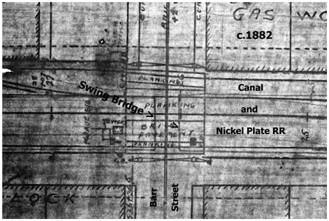
I never realized that the canal was that far below grade at any point in the city.
A highway swing bridge over a canal is seen above. It’s like the Barr St. bridge except that the Barr St. bridge was operated by mules and this one was opened by the boats.

A canal boat would approach the bridge between the horizontal guides and bump the right end. It would pivot at the left end and open, and the boat would pass thru (a “bump bridge”).
The suspension/girder railroad deck bridge beyond it was too heavy to be opened by bumping, so a “minimum of two men” turned a large crank in the building at the left that opened and closed the bridge.
If I ever complete the book about the Findlay-Ft. Wayne railroad, the original B & W version of this photo will be in it.
Canal Notes # 19: Appleseeds
Tom Castaldi

Johnny Appleseed Park on Fort Wayne, Indiana’s north side, is celebrated as John Chapman’s burial place. In fact, Chapman, popularly known as Johnny Appleseed, is not in the marked grave, but is resting nearby in a place no one can pinpoint with any certainty.
What is buried in the park are several hundred yards of the Wabash E Erie Canal feeder line. It carried water from the Saint Joseph River about three miles north of the park, to the canal’s main line another three miles to the 1835 postcard of Johnny Appleseed’s grave in Fort Wayne, Indiana southwest.
Records are clear that here the canal feeder is covered over in the park named for the man who so gently covered seeds with fertile soil.
This feeder provided the water to the canal that floated the boats that brought the pioneers of Johnny Appleseed’s day to the region.

Actually, the channel depression can be traced today following the big I & M power line towers that are anchored in the old canal bed.
A small stream flowing through the park was there in the 1830s and had to be crossed. Long gone is the water bridge, known as Culvert No 4, that allowed water to pass down the feeder line.
Johnny Appleseed’s spirit is kept alive near the buried channel that gave life-giving water to the longest canal in America.
Johnny gave us apple trees, the other gave us the people to tend them and harvest their fruit.
Reminiscences Of Canal Travel In 1851
From Stories of Indiana by Maurice Thompson, 1898, American Book Co. and republished in Indiana Waterways, Wol 5., Winter 1986.
The following excerpts ere taken from private letters written in 1851 by a young lady from Louisville, Kentucky, who was passing through Indiana and going into Ohio by canal boat on the Wabash & Erie Canal. The canal was only open to Newberry, Indiana at that time, so she would have boarded the boat either there or somewhere northeast of there. On the whole, her letters give a true impression of what travel by canal boat was like.
July 1851
“We went on board, by way of a board, a gangplank, that is, and soon found ourselves in a dark, hole-like room, where it was hard to breathe and impossible to see plainly. There was a queer smell; Tom [her brother] says all canal boats have that odor. Of course, this being my first experience, I cannot say how true it is. We presently went up a steep little stairway and came out upon the top of the boat, which was already in motion, — very slow motion, though, — and the dingy houses began to slide, so it looks, back to the rear. A single horse pulls our vessel, and the loutish boy who manages him has hair that is as white as tow. It looks as thought he had never combed it. He chews tobacco and swears at his horse; but yet he seems good natured, and he sings between oaths some very doleful hymns, alternating with love songs of a lively cast. Sometimes the horse pokes along; sometimes the boy makes it trot for a short distance.
“I am sitting on a stool on top of the boat, writing with my paper on my knees. The mosquitoes bother me some, but they are not very thick, though the ponds along both sides of the canal in the flat lands look like good places for them to breed in, all covered with green scum. The first lock that we went through caused me to have a very queer feeling. Our boat entered a place where the sides of the canal were walled up with logs and plank, and stopped before a gate. At the same time a gate was closed astern of us, and then the boat began to rise up, up, as the front gate was slowly opened. By this means we were lifted to higher level, upon which we proceeded. But when the boat began to rise, I felt as though something dreadful was about to happen.”
Her second letter gives a graphic account of her first night’s experience trying to sleep in a bunk on the boat.
“It seemed that all of the heat spent by the sun during the day settled down into that hot and stuffy little room, and that all the mosquitoes ever hatched in the mud puddles of Indiana were condensed into one humming, ravenous swarm right around my hard little bed. Tom went up into the open air on top of the boat and spent the night. How I wish I was a boy! All night I lay there under a smothering mosquito bar and listened to the buzzing of the insects, perspiring as I never supposed that anybody should. It was awful, horrid! It seemed that daylight was never going to come again. Every once in a while I heard men’s voices. The boatmen talking, probably, but they sounded strangely. Chickens sometimes crowed in the distance. About morning I fell fast asleep, and did not wake until some shouting voices startled me.
“We had reached a little town where the boat had some business, taking off many barrels and boxes and sacks, and taking on more. I was glad to get up and hurry on my clothes and climb out on top of the boat. I saw some queer-looking people. Men, women, and children came crowding down to the little plank wharf to stand around and gaze. Such clothes! The women looked strangely vacant and ignorant; but some of the young ones were dressed in a way that made them show off. Red Calico was most conspicuous. They all wore pink sunbonnets. The children had apparently never combed their heads or washed their noses.”
She hates the food and describes the people and countryside in her third letter.
“It has been a dreadfully hot day, but a good wind has been blowing from the northwest, and just now it is getting cooler as the sun is going behind clouds in the west. We have passed through some lovely country, where rich farms, like those in some parts of Tennessee, stretch away as far as you can look. On our left a short distance away the Wabash River had been in sight most of the time, and beyond it large fields of bottom land waving with luxuriant young corn. On our right the farms are more rolling in places, but fertile and well kept; all the houses are miserable looking. I have not seen a single homelike farmhouse for a hundred miles, it seems to me.
“You cannot imagine how tedious this way of traveling is. You creep along like a snail in perfect silence. There are two horses to our boat now, but we go slower, I think. Our present driver is a little red-headed man, not larger than a twelve-year-old Kentucky boy. He never curses, but he smokes a pipe all the time. I can smell the dirty ting just as strongly as if I were walking by his side. He wears no coat and has but one suspender, a dingy blue, over his red shirt, slanting across his back. He appears to be well acquainted with every person that comes along, and always has somethings smart to say. He is dreadfully bow-legged and he steps farther with one foot than the other.
“To-day is Sunday, and the people all seem to be fishing in the canal. We have passed hundreds of them sitting on the banks with poles in their hands and dangling their fishhooks in the water, but I have seen no fish caught. The boatmen sauce them and they retort pretty roughly sometimes.
“The most disagreeable part of this kind of traveling is, next after the sleeping, the eating. You know how I like good things to eat. Well, just imagine the dining room on one of our river packets, and then turn to my canal-boat ‘salle á manger.’ To get to it from the cabin I have to climb up a ladder through a hole to the top of the boat, then go down through another hole into a suffocating box. The table is horrid, so is the cooking. Pork and bread, bread and pork, then some greasy fish, mackerel, and bitter coffee lukewarm, three times each day. I am raving hungry all the time, and nothing fit to eat. I makes me violently angry to see Tom gorge like a pig and pretend that stewed beans and catfish are delicious.
“The little towns along the canal are forlorn looking places; but they seem to be doing business. Tom says that some of the men are getting rich. I do not see the evidence of it if they are. Such houses as they live in are advertisements of hopeless ‘greenhorn’ existence. Our kitchens are far better than their drawing rooms.
“Tom and I went out into one village where the boat remained two hours and a half, and I got into the best looking house in the place by asking for a drink of water. Things were worse inside than out. There was a bed in one corner of the parlor, and no carpet on the floor. Five little dirty children came in to gaze at me. They all seemed to be of the same age. One fat, big-eyed chap, a boy I think, but they were all dressed alike in calico slips, came up close to me. I wanted to hug him because he was saucy-looking, and I wanted to spank him for not keeping his nose clean. I concluded to do neither.
“For hours today we sneaked along on a prairie. I think that sneaked exactly expresses it, or the boat acted as though it wanted to creep up to something and take it unaware. Tom has been shooting at some big cranes flying up out of ponds in the grassy open lands. He killed one, but could not get it. It fell in the middle of a muddy pond, where it fluttered awhile. Why do men and boys like to do such cruel acts?
“Last night it rained and thundered terrible. There was a leaky place right above my bunk, and some drops of water kept up a tattoo, first on the sheet, then in my face. It was soon over, and then a delicious cool feeling came over me, and I slept till long past daylight. This morning the air smells ever so sweet. We shall soon be in Ohio, but they say that is worse still than Indiana. I heard a man speaking about a town of the name of Wawpuckenatta*, if that is how to spell it. What names they do have! The public roads in many places run along close to the towpath of the canal, and I see people in wagons. They go faster than we do. I am outrageously tired; but Tom is delighted. It seems to suit him exactly.”
*Waughpaughkonnette,” possible meaning place of white bones, was a Shawnee settlement established in the 1780s. After the Indian removal in 1831, Wapakoneta was platted in 1833.
Her fourth letter had the following short excerpt:
“Last night just after I had retired we reached a village, and pretty soon after the boat stopped I heard loud talking and swearing. More and more voices joined in, a good many of them unmistakable Hibernian. Then there were cries and shouts, a gun or pistol shot off, then a pandemonium. Before I fairly knew what I was about I had put on some of my clothes and clambered up to the boat’s top. A terrible fight was going on at the wharf. There were twenty or thirty drunken laborers on some public work and they were fighting, the Irish against the Americans. It was dreadful. Somehow our captain got into the mêlée, and today has his head tied up and his cheek patched. They would not let our boat go, but kept us there until near two o’clock. Some officers came about eleven, but they were driven away with clubs and stones. Tom stood by me with his gun ready, but no one came up where we were. I never was so terribly frightened. How we got away at last I cannot say. The officers did not come back, and the men quarreled and swore and fought all the time. You may be sure I was glad when the boat began to move along. What seemed terrible to me was that there were women all mixed up in the row, and they swore horribly.”
F. C. Brase Paid Toll for Boat at Covington
Carolyn Schmidt
Old canal boat toll records found in Covington, Indiana show the following:
On May 21, 1862, F. C. (Frederick Christian) Brase’s boat the “Wyman” came 175 miles into Covington, Indiana on the Wabash & Erie Canal from the Indiana/Ohio State Line empty, so he only paid a toll for the boat of $4.38.
A day later he paid a toll for his loaded boat heading for the state line.
On May 22, 1862, F. C. Brase’s boat the “Wyman” cleared at Covington, Indiana and was going to the Indiana/Ohio State line with 957 bushels of wheat, 887 bushels of corn, 100 barrels of flour, 2 barrels of beans and 1 box of beeswax for a total of 175 miles, the rate of 2½ cents per mile for boat = $4.38, wheat $25.27, corn $20.37, flour $8.85, beans and box of beeswax $. 20, all measured by weight, for a total toll of $59.07.

1821-1903
Find-A Grave
36580954
Frederick Christian Brase, was born on November 1, 1821 in Loh, Minden, Germany, immigrated to the United States in 1844, and married Christina Wilhelmina Meyer in 1848 at St. Paul’s Lutheran Church in Ft. Wayne. The 1850 U.S. Census shows them having a daughter, the 1860 U.S. Census shows them having 5 children, sons William, Theodore, August with two addresses. 75 W. Jefferson and 301 W. Jefferson, business and home. He helped on construction of the Wabash & Erie Canal. He was the captain of a canal barge “ U. S. Grant” that ran between Fort Wayne and Huntington and owned a trucking business. He later purchased a second boat “President Hamilton,” according to Terry Meyer, his great-great-grandson. He was said to have been the oldest boat captain in points of service on the canal. Later he went into the trucking business. He died from infirmities of age. At the time of his death Frederick had twenty-six grandchildren and seventeen great-grandchildren.
Frederick belonged to Emmanuel Lutheran Church and he was one of its founders. Funeral services were held at his residence on Sunday afternoon at 2 o’clock and at 2:30 from Emmanuel Lutheran Church with Rev. William Moll officiating. Interment was in Concordia Lutheran Cemetery, Ft. Wayne, Indiana.
Frederick was the uncle of William Homeyer (Homer, Homeier) , a crewman on Fredeerick’s canal barge whose family resided on the first floor of the Canal House in Ft. Wayne. Christian (William) Borgman, the captain of the canal boat “Coral,” and his family lived on the second floor. The men liked the building’s location on the canal because their boats could be tied up at the rear of the building.
Frederick’s son, William C. Brase was born in 1858-59 and died on March 21, 1939 at age 80. He was life long resident of Allen County, Indiana and a teamster on the Wabash & Erie Canal. He was a member of the English Lutheran Church at 4211 Clay Avenue and the Old Aqueduct Club. He is listed on a plaque beneath the 1922 “Let’s Go Swimming” statue of boys who swam in the old St. Mary’s aqueduct. He was living in Naples at the time of his mother’s death.
The following picture was given to the Canal Society of Indiana by Mrs. Goshert, a descendant of William, on Jun 27, 2016. He was her great-grand-father. William is pictured in the center of the photo behind the big chair and under the tent pole. This crew of men are working on rebuilding the Gronauer Lock #2 of the Wabash & Erie Canal east of New Haven, Indiana.

William went on to be owner and captain of two canal boats. One was name the “Wyman” as seen on the Covington toll records.
The 1920 U. S. Census show William and his wife, Dora, living at 2711 New Haven Avenue. Dora’s mother, Margaret Mueller Westrumb, is living with them.
William died on March 21, 1939 at age 80. His obituary in The Fort Wayne Journal Gazette says his body was taken to the Klaehn & Sons’ funeral home in Fort Wayne. At the time of his death he had 25 grandchildren and 19 great-grandchildren living.
Brase Genealogy
Frederick Christian Brase
b. Loh, Minden, Germany Nov.1, 1821
m. Aug. 17, 1848, St. Paul’s Lutheran Church, Ft. Wayne, Allen County, Indiana by Rev. Dr Sihler
d. Sept. 1903 age 82
Christina (Maria) Wilhelmina Meyer
b. Hanover, Germany 1826
m. Aug. 17, 1848, St. Paul’s Lutheran Church, Ft. Wayne, Allen County , Indiana
d. Feb. 7, 1899 age 73
Children (7)
Mrs. Sophia Jung (died in 1877) the eldest
Mrs. Chris F. Cook
Mrs. Frederick Hohnmeyer
Mrs. Philip H. Bender
William C. Brase (a carpenter in the Pennsylvania shops, Ft. Wayne)
b. 1858-59
m. 1883 Dora Westrumb (b. 6-30-1861, d. 3,21,1923 age 61)
d. Mar. 21, 1939 age 80
o. Fort Wayne Journal-Gazette March 22, 1939
| Children (5) as listed in obituary | Children as listed in the 1900 U. S. Census |
| Arthur Brase | Clara 16 |
| Mrs. Fared Lipp, Detroit | Amelia 14 |
| Mrs. Joseph Guethe, Ft. Wayne | Arthur 13 |
| Mrs. Jess W . Walker, Ft. Wayne | Francis 10 |
| Mrs. Lawrence C. Meyer, Ft. Wayne | Estella 6 |
Theodore Brase (a driver for the South Side cereal mills, Ft. Wayne)
August Brase (a grocer at Jefferson and Webster streets, Ft. Wayne)
Sources
- “Frederick C. Brase, Aged Pioneer, Is No More,” The Fort Wayne Sentinel, September 10, 1903.
- Griswald, B. J. The Pictorial History of Ft. Wayne. Chicago, IL: Robert O. Law Company, 1917, p. 384.
- Meyer, Terry. Great-great-grandson of Frederick Brase.
- Mrs. Goshert. Great-granddaughter of William Brase.
- Indiana U. S. Marriage Index 1800-1941. Brase
- “Pioneer Local Resident Dies,” The Fort Wayne, Journal-Gazette, March 22, 1939.
- Schmidt, Carolyn. “Canal House Rich in History,” Canal Society of Indiana Newsletter, February 2002.
- Toll Book Clearance Records 1862 Covington, Indiana. F. C. Brase
- U. S. Federal Census 1850, 1860, 1900, 1920
- Wilkens, Cleo Goff. Obituary Records Found in Fort Wayne Indiana Newspapers 1841-1900. 1962.
1839 Document To Lease Water From Central Canal For A Mill
Carolyn Schmidt

toric Landmarks, and Jeb Conrad, Indianapolis Water
Company holding the water lease and books that
were presented to CSI in June 1993.
Over thirty years ago in June 1993 seventy-five members of the Canal Society of Indiana held a 2-day tour of the Central Canal in Indianapolis led by Jerry Sargent, CSI member from Indianapolis. On Friday night we a toured the State House led by Senator Larry Borst. His assistant, Dr. Richard Gantz, the DNR Director of the State Museum and Historic Sites, gave a talk about maintaining our heritage sites such as Metamora. On Saturday we visited the White River State Park, the Indiana Historical Society and Indiana Landmarks. On the steps of Indiana Landmarks Jeb Conrad, representing the Indianapolis Water Company, presented Canal Society of Indiana president, Bob Schmidt, a gift of $500 dollars, several books about the Indianapolis Water Company’s history and the following document that leases Central Canal water rights for a mill that was signed by Noah Noble.
The following document is folded. On the outside cover it says:
Caslisle, Flour Mill at Inds. C C C
The mill commenced running with two run on the 20th Sept. 1840 and the rent was charged from that time.
S. Day, Superintendent
THIS AGREEMENT made this thirteenth day of August 1839 between the State of Indiana, party of the first part, by Noah Noble,
acting Canal Commissioner, thereto dully authorized by law, and by the order of the Board of Internal Improvement made in
pursuance thereof, and John Carlisle party of the second part, WITNESSETH:
That said party of the first part, in consideration of the rents reserved, and the covenants for the party of the second part
hereinafter contained and upon the express condition that the party of the second part, shall continue during the whole of his term
to comply with all and singular the limitations and conditions, hereinafter contained, and shall in every respect, perform all the
stipulations of this agreement by said party to be performed, agrees to sell and lease to said party of the second part for the term
on thirty years from and after the thirteenth day of April 1840 subject to the restrictions, limitations, and conditions, herein
contained, the use and occupation of so much of the surplus water not required for the purposes of navigation at the South end of
the ujpper basin in the town of Indianapolis on the Central Canal as will be sufficient when properly applied on an overshot wheel
of sixteen feet in diameter with the proper gearing to be approved by the acting Commissioner and Engineer having charge of that
portion of the canal to propel four run of four and a half feet (4½ ft) mill stones to be applied to the manufacture of flour.
It is understood that when the mill shall be in good order and the machinery with the necessary apparatus as above described shall
be in full operation, the quantity of water flowing to and used by said mill shall be accurately gauged by some competent Engineer
to be selected by said acting Commissioner or other authorized agent of the State at such time, as said Commissioner may deem
proper and the quantity of water then found necessary shall be certified by said Engineer on the back of this contract, which
quantity shall thereafter be considered the amount leased. The water will be taken by a suitable head race from the level or pool
immediately above the mill and after passing over the wheel will be regulated and controlled by a permanent regulating weir to
be constructed in the most substantial manner with stone side and breast walls agreeably to a plan to be furnished by the
Commissioner or Engineer to be built in every respect according to their direction so as not to endanger the safety of the canal nor
prevent the regular and necessary flow of water from one level to another.
And the said party of the second part, for and in consideration of the right to the use and occupation of said water, agrees to pay
to the state a yearly rent or sum of one hundred and fifty dollars ($150.00) for each power, that is to say for each portion or
quantity of water sufficient to propel a run of 4½ feet mill stones with the necessary apparatus for flouring wheat with the same
fall and on a similar wheel to be determined by the Engineer aforesaid, each run of stone being approved to grind on an average
five bushels of wheat per hour provided the party of the second part shall not be deprived of the use of the water by any act of
the state or its agents or by the inadequacy of the supply of water for more than one month in the aggregate in any one year. And
if for the purpose of repairing the canal, preventing breaches, removing bars or other obstructions, or making any improvement to
the canal or the works connected therewith, or in consequence of the breaches, or the inadequacy of the supply of water, the
party of the second part shall be either partially or wholly deprived of the use of anyh portion of water power hereby leased, so as
to prevent the operation of any of the hydraulic works usually propelled by the water power hereby leased, such deduction shall
be made from the rent accruing on such portion of the water power as the said party is so prevented from using, as will bear the
same proportion to the yearly rent thereof, as the time during which the said party has been deprived of its use, bears to eleven
months. The rent to commence of the thirteenth day of April 1840 and to be paid semi-annually thereafter, on the first days of
May and November in each and every year during the continuance of this lease to such agent of the state as may be authorized by
law to receive the same.
And it is further understood, that the necessary regulating wier, head race, and trunk to conduct the water to the wheels, and the
tail race to pass it from the wheels to the Canal as above specified are to be constructed by the party of the second part at his own
expense and according to the direction of the acting Commissioner or Engineer on this portion of the canal, and to be kept in good
repair so as to prevent the waste of water.
It is further agreed that the party of the second part during the continuance of this lease, shall at his own expense, keep
constantly in good repair the race or trunk, above described; and if any breach or other injury shall at anyh time occur to the canal
in consequence of the race or trunk not being faithfully constructed, or being suffered to be out of repair, or from any negligence
of any person employed about the mills, then the said party of the second part shall forfeit and pay to the state the whole cost of
repairing such breach or injury. And if the said party of the second part shall refuse or neglect to rebuild, repair or strengthen said
regulating weir or other works necessary to the security of the canal after being notified in writing by the Engineer,
superintendant or other proper agent of the state that such renewal is necessary for the safety of the canal, such refusal or
neglect shall subject the party of the second part to a forfeiture of this contract or lease at the option of said Engineer,
superintendant, or other agent of the state in charge of this portion of the canal.
It is expressly understood and agreed by and between the parties, that for the purpose of preventing or repairing breaches,
removing obstructions to the navigation of the canal, or for the purpose of making any improvement in the canal, any authorized
agent of the state may cuase the water to be drawn out of the canal, and to remain out so long as may be necessary. And the
party of the firt part futher reserves the right to resume at any time the use of the water, hereby leased, whenever this shall
become necessary for the purposes of navigation; and if it shall become necessary to resume the use of so great a portion of the
water hereby leased, or of the whole thereof for so great a portion of the time, as to destroy the value of the privilege (which fact
shall be determined by three judicious disinterested freeholders, one to the chosen by the acting Commissioner or other
authorized agent of the state, one by the party of the second part and the third by the two thus chosen) then the party of the
second part shall be absolved from such time, from all further liabilities growing out of this agreement, and shall also receive such
compensation for his improvements as the said freeholders may consider their fair value.
It is further agreed, that at the expiration of the term of this lease the acting Commissioner or other authorized agent of the state,
shall give public notice that proposals will be received for the water privilege hereby leased for a like term of years, which notice
shall require that each proposal be accompanied with an agreement on the part of the bidders to pay the party of the second part
for all permanent and valuable buildings necessarily erected by said party of the second part, for the use of the water, at such
It is further understood and agreed that the rents of only two runs of stone are to commence and be paid at the times above
stipulated and that the rent of one run is to commence on the thirteenth day of April 1840 and be paid on the first days of May
and November in each and every year during the continuance of this lease and that the rent of the remaining run to commerce on
the thirteenth day of Octobrer 1841 and be paid semiannually thereafter on the first days of May and November in each and
every year during the continuance of this lease in witness whereof, the said parties to this agreement have hereunto set their
hands and seal the day and year first above mentioned.
Signed, sealed, and delivered in the presence of N. Noble Com. (SEAL)
John Carlisle (SEAL)
According to an article by H. M. Rudeaux entitled “Over One Hundred Years of Service: Acme-Evans Company, of Indianapolis, Ind., Completes New Corn and Feed Milling Activities), Volume 4 Issues 4-12, page 12 published in 1926:
“In 1840 John Carlisle built a mill, the successors of which were the two mills owned by the Acme Milling Company. The mill John Carlisle built in 1840 was a large merchant mill in the arm of the [Central] canal near the point where it crosses Washington street [in Indianapolis]. It was at this mill Mr. Carlisle manufactured and packed in barrels the first flour manufactured for shipment in this section of the country. In this enterprise he was ridiculed and laughed at by his friends for wagoning flour to the Ohio river to sell at from $2 to $3 per barrel. Although not profitable at first, he built up a reputation for this flour in after years.
“The old records of the Carlisle’s mill show that in 1842 wheat was bought at 25 cents per bushel, corn at 10 cents, and that flour was sold on the Ohio river at $2.75 per barrel. Cornmeal was sold in this city eight bushels to the dollar, bran at five bushels, and shorts at 10 cents per bushel delivered in the city.
“In the years 1864 and 1865 transactions in grain and flour amounted to $1,000,000.
“When the Civil War closed, the mill was the most prominent in the west. Flour was on sale in all eastern as well as western cities. In 1864 and 1865 between 25,000 and 30,000 bushels of corn were purchased in one week. Cash amounting to nearly $100,000 was paid therefor. The institution bought a greater number of bushels of grain and expended more money among the farmers than did any other business in the city.”
John Carlisle did very well with his mill on the Central Canal and bought another mill that was located on Fall Creek in northeastern Marion County, Indiana. This mill had been erected on property purchased though a government land grant for $300 by Peter Negley and was known as Brubaker’s Mill. Three grist mills were located on this creek. Spahr then owned the mill for several years until he sold it to Winpenny. After Winpenny died, his heirs sold it to Tobias Messersmith, who found it was very profitable to sell the mill when prices were high during peak grinding season and buy it back during off season when prices were low. He did this three times. The first was to William Sala. The second to John Carlisle. While Carlisle owned it, it was destroyed by fire and Carlisle completely rebuilt it and filled it with modern equipment. [This was actually the third time the mill had burned. Flouring mills were so dry and dusty that they caught fire easily.] We do not know how long Carlisle owned this mill before Messersmith bought it back and sold it to Russell. Russell then sold it to another Sphar (William H.). It was finally torn down around 1906 and its timbers were used in building Schofield mill.

John Carlisle Genealogy
Birth: 1807 County Down, Northern Ireland
Death: August 29, 1890 (aged 82-83)
Burial: Crown Hill Cemetery, Indianapolis, Indiana
Plot: Sec: 38, Lot: 1
Memorial ID: 45900277 Find-A-Grave
Family Members:
Spouses:
Agnes Gray Carlisle 1825-1854 (m. 1850)
Mary Dusenbury Carlisle 1818-1846
Margaret J. Boyd Carlisle 1825-1894
Children:
Jane Jennie Carlisle Bradshaw 1830-1860
Henry D. Carlisle 1838-
Lucy Carlisle Phelps 1843-1910
William Carlisle 1845-1891
John Carlisle 1852-1869
Stuart Boyd Carlisle 1859-1879
In Nowland, John H., Sketches of Prominent Citizens of 1876: With a Few of the Pioneers of the City and
County Who Have Passed Away, is the following sketch about John Carlisle’s son, Henry D. Carlisle. He
followed in his father’s footsteps.
“Henry D. Carlisle was born in Indianapolis on the 10th day of April, 1838, while the [Central] canal was in course of construction, and resided near its banks. Lived here until 1856, then took charge of mills at Waverly, Morgan county, there remained two years; thence to Connersville, Fayette county, where he also remained two years; then returned to Indianapolis, remaining eighteen months; thence to Minnesota and lived one year, again returning to his native town. In 1868 he built the Home Mills, and managed them until 1874.
“Mr. Carlisle was married in 1860 to Miss Jane A. Teal, of this city. In September, 1875, he was elected
secretary of the Board of Trade of this city. Mr. Carlisle is the son of that well known citizen and veteran mill owner, John Carlisle. Henry D. Carlisle is about six feet in height.”
Great Time To View Canal Structures
Text by Carolyn Schmidt,
Photos by Bob Schmidt
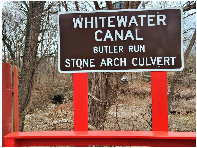

On February 26, 2025, Bob and I drove to Sharonville, Ohio to pick up the latest batch of canal signs from CDS signs. The weather was beautiful and the temperature reached 60 F. This was a perfect day to view canal structures. The ground was still covered with leaves and there was no spring plant life seen coming through them. The trees had not started to bud out. Just driving down the road along the Whitewater Canal we could clearly see the canal prism, the lock remains and culverts. The culvert below is on private property, which has a posted “no trespassing” sign, and is normally difficult to see from the road. CSI placed a sign at the local pizza place nearby, but until now had difficulty in photographing the structure due to vegetation cover. This stone arch structure carried the Whitewater Canal over Butler Run, a stream that fed into the Whitewater River. The first photo is taken from the pizza restaurant with the culvert in the background. The second is taken from the bridge over Butler Run on S.R. 52 near Brookville, Indiana.

We also had time to visit the library in Brookville to see if they had information about the Whitewater Canal that we had not seen before and if there was anything about the canal that we could give them for their collection. We told the librarians about our website, gave them our QR cards listing what was available on the website, and asked them to refer anyone who had further canal questions to us.
In the limited time we had at the library we found the following pictures in the vertical files. The first is of two men at the Laurel, Indiana stone quarry. This quarry had very good stone and is the reason the Whitewater Canal locks, culverts, piers, etc. were built of stone.

A crowd formed on the Whitewater Canal near the stationary bridge that crosses the canal in Metamora, Indiana when the Ben Franklin replaced the earlier Valley Belle, a small motor powered excursion boat. This new boat weighed 14 ton and was constructed of oak and redwood. The Valley Belle was put in storage.

The north side of Duck Creek Aqueduct that carried the Whitewater Canal over Duck Creek, which flows into the Whitewater River at Metamora, Indiana, was a covered bridge style structure with its northside open. This is taken looking toward the east end of the aqueduct. It shows how the structure was built. This photo was from an old calendar according to the librarians and they had no information about who published the calendar or took the photo.
Whitewater Canal Byway Association Annual Meeting

to Cassie Roth Garret
The annual meeting of the Whitewater Canal Byway Association was held at Third Place in Brookville, Indiana on February 26, 2025. Following a welcome and opening remarks by Tom Horninger, and a prayer led by Joann Koch, a fried chicken dinner was served followed by an election of officers for the upcoming year.
Elected were Ron Yurcak, president; Tom Horninger, vice-president; Cathy Vandivier, secretary; Shelly Kozlowski, treasurer; and board members Dave Cook, Joann Koch, Cassie Garrett, Duane Nickels, Stephanie Beaty, Aaron Kozlowski, Joey Smith, and Candy Yurcak.
Those attending had hoped to hear that a grant along with the money raised by WCBA would match the 7 million dollars required by the state to start the project to restore the canal. And the old depot. Candy Yurcak announced that they had just heard back from the grant application and learned they did not receive it this year. Candy is always optimistic and said they would reapply next year. They will also have an art auction, keep the visitors’ pavilion for Scenic Byways open, and meet once a quarter with other CVB’s to coordinate with their events.
Keynote speaker was Cathy Ferree, President and CSO of Indiana State Museum and Historical Sites. She brought two others from her group to speak about what they are planning to do toward getting the Whitewater Canal, Duck Creek Aqueduct, Laurel Feeder Dam, etc. back into operating order. Getting a canal boat will be considered after the canal work is done. They first have to study, evaluate, etc. before anything will be done. This year they did remove and repair damage done to the aqueduct by a tree falling onto it.
The “Spirit of the Byway” Award was presented to Cassie Roth Garrett, content and news-room team leader for Whitewater Publications ,for her articles in the newspaper about the canal, her work at canal days, etc.
CSI members attending: Phyllis Mattheis, Dr. Ron Morris, Bob & Carolyn Schmidt, Mick Wilz, Ron & Candy Yurcak

News From Delphi
The following excerpts and pictures are from “Currents, ” the news from Wabash & Erie Canal Park in Delphi, Indiana.
Lake Wabash

This article by Tom Castaldi, CSI director from Fort
Wayne, Indiana was previously published in The
Tumble, CSI’s news and journal, in the May 2024 issue as “Canal Notes #13—Lake Wabash” with pictures. At that time we did not have this excellent map of the Wabash & Erie Canal, Wabash River, and the location of the dam. This map greatly helps in visually seeing the canal in this area.
Delphi Bayou Update

In the March 2025 issue of The Tumble there was a picture of the entrance to the new boardwalk in Canal Park. Exhibits along this boardwalk will be about the Native Americans who resided in the Wabash Valley until many of them were forced to move, the early settlers who established new homes in Indiana, and a full scale reproduction of a canal construction site.
Funded in part by a grant from the Wabash River Heritage Corridor Fund administered by the Indiana Department of Natural Resources, Division of Historic Preservation and Archaeology, this project will share more than the heritage and role of women in Miami life and among the early settlers of Carroll County. It will have an array of new interpretive panels, replica dwellings of both white settlers and Miami people, a forest maze, animal and plant identification activities, and even more surprises.
Historic Trade Classes
This year eleven classes are being offered that range from just a few hours, all day or multiple days this May and June. More details are on their website. Don’t miss this opportunity to learn something new to you that is actually very old.
| May 17 | Wool Felting Shaving Horse Weaving |
| May 24 | Nami Express Broom Making Beginning Spinning |
| May 28 | Pine Needle Bowl |
| May 30-31 | Coopering Bucket |
| June 6 | Backpack Basket Making |
| June 14 | Advanced Spinning Hand Quilting |
| June 21 | Dyeing |

Memorial Day
Preston Richardt
The practice of decorating the graves of fallen soldiers with flowers emerged during and after the Civil War, with communities coming together to honor those lost in battle. Since most companies, if not regiments, originated from the same community or geographical area of a state; when a large battle would occur with large amounts of casualties, this would devastate the counties, communities and families where within. The different branches of the military continued to be organized in such a manner up to and during World War II. As a result in the Japanese attack on Pearl Harbor, three (3) brothers died on the USS Arizona when it was sunk. In order to prevent this type of loss from a single family in the future, the military adopted an unofficial policy they attempt to abide by, Sole Survivor Policy. Back to Memorial Day History.
The first recognized observance of Decoration Day occurred in 1866 in Waterloo New York. Then in 1868 the commander-in-chief of the Grand Army of the Republic called for a national day of remembrance on May 30 to decorate the graves of the fallen men of the American Civil War. The first national observance of Decoration Day took place in 1868 at Arlington National Cemetery, where 5,000 people helped decorate the graves of Union and Confederate soldiers.
After World War I, the holiday came to be known as Memorial Day, as it expanded to honor those who died in all U.S. wars, not just the Civil War. In 1971, Congress passed the National Holiday Act, establishing Memorial Day as the last Monday in May.
Today, Memorial Day is observed on the last Monday of May with common traditions including a visit to cemeteries or memorials, participating in parades, and the National Moment of Remembrance at 3 p.m. local time. However many people have forgotten that this is a day to remember those men and women who died for their nation. Families and friends gather now to celebrate the unofficial start of summer with little or no mention for the real reason of the holiday.
It is important to remember that Memorial Day is a day of remembrance and reflection, not a “happy” holiday. Even though I never served in the military, the reason for Memorial Day is not lost on me nor my family and that is why I try so hard not to say “Happy Memorial Day” for it is not appropriate to wish someone a “Happy Memorial Day” on this sacred day of remembrance.
That said, from my family to yours have a safe holiday weekend and please take a moment to remember those who gave the last full measure for us; additionally, say a prayer for those who still serve and fight for our nation.
Source Material:
