

March 2024 Articles
- Bridging Waterways
- Samuel Wilson “Judge” Parker: His Life And Whitewater Canal Years
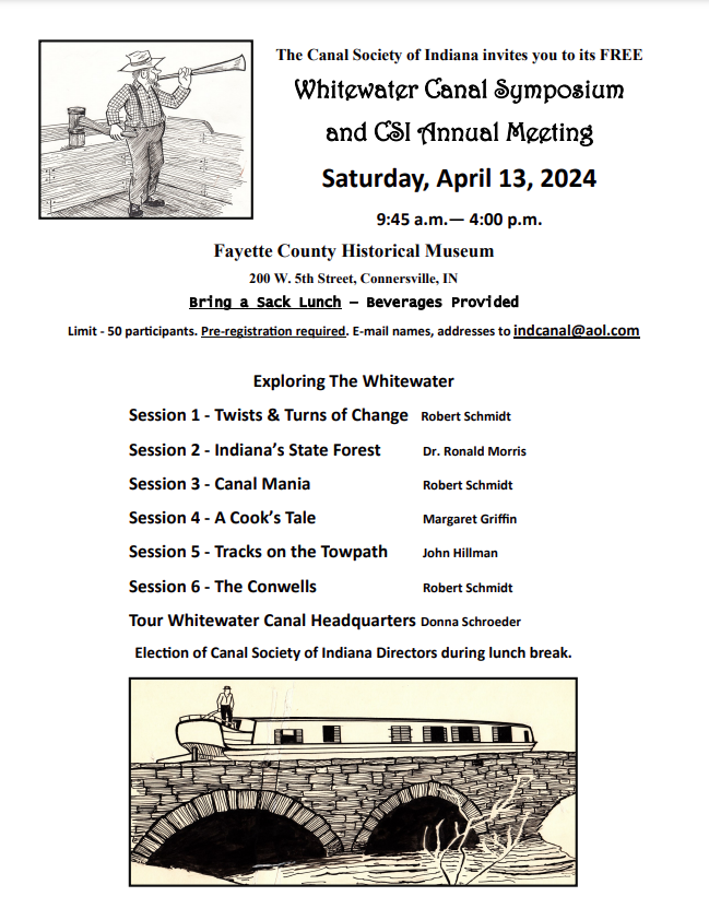
- Invitation To Whitewater Symposium
- Vanished Canal Life Returns In More Bash Interviews
- W & E Canal Grocery Order
- Many Hands Help Signage
- New Sign To Mark Canal Timbers
- Jerry Mattheis Memorial Signs Erected
- 1.9 Million Grant For Riley Trail Project
- Ft. Wayne’s Canal House Restored
Bridging Waterways
By Robert Schmidt
One of man’s early challenges was how to cross waterways. If he encountered a pond or large lake he could walk around it. As civilization developed, lakes were crossed by boats, canoes or rafts. However, crossing linear waterways such as creeks, rivers, or, even later, canals, presented a larger problem. At first he probably used fallen trees or logs to cross small streams. In the Andes, the Incas used rope to build their bridges. The Romans built bridges and aqueducts of wood or stone.
Wider waterways were often crossed by a boat or a ferry. The word “ferry” is found as far back as the 12th century. Both boat and ferry crossings required that a fare be paid to the owner and both usually followed a certain route (point to point) and were often on a specific schedule.
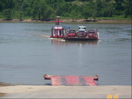
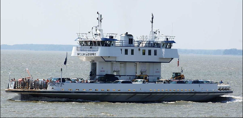
Not all ferries have been replaced with bridges. Today, we have the flat platform type of ferry on the Ohio River at Cave-in-Rock, Illinois, and auto ferries such as those found on the James River near Jamestown, Virginia. Before powered engines, the early platform ferry followed a cable and required poling across the river.
Although crafts similar to those used on lakes could be used to cross wide rivers, they were cumbersome to use on smaller streams. It was more efficient to build a one span bridge, bank to bank, across a narrower waterway. Wider waterways required a bridge of several spans with each span being supported by a wooden or stone pier between spans. In times of flooding debris accumulated at the base of the piers that could destroy the bridge.
To fund the construction and maintenance of these bridges some became toll bridges. Even as late at the 19th century, the building of massive bridges like those of today was impossible with the existing equipment and technology at that time. It wasn’t until 1847 that bridges were built across the Wabash River at Terre Haute and Lafayette, Indiana.
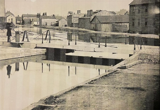
In our study of canals we usually focus on the canal channel or “prism” and the structures that supported it—locks, culverts, and aqueducts. An aqueduct, like a bridge, carried the canal over an existing waterway. Some aqueducts were left open while others were enclosed. Just like covered bridges, abutments and stone piers supported the trough of the aqueduct. Since they were essential to the operation of the canal, their maintenance was the responsibility of the State of Indiana and later the Canal Trustees.
Canal engineers had to provide a means for local residents to cross the canal itself. Even though the locals demanded a canal be built and benefited from its operation, they still required daily access to both sides of the canal, which had been built between their properties, homes or workplaces.
Not only was the canal itself an obstacle to cross, the bridges built over it were obstacles to moving boats along the canal route. Bridges slowed down the canal traffic. They had to either be moveable or high enough for boats to pass beneath them. Some of these bridges were constructed by the canal contractors. They were usually located at state roads or major street intersections. After their construction some of these bridges were turned over to local communities to maintain. Other bridges were also constructed over the canal by local citizens. Although tolls were collected on the canal for passengers and freight, based on weight, cargo value and distance, bridge tolls were not usually collected to cross the canal.
In 1847 the Wabash & Erie Canal was turned over to a Trust of the bondholders. At this point an inventory was taken of all structures along the canal. Then in 1853, when the canal was finally completed to Evansville, another inventory was taken. These inventories show that Indiana had 172 bridges over the mainline of the Wabash & Erie Canal. The numbering system used in this article is based on the enumeration from the Ohio/Indiana State Line to Evansville.
There were various types of bridges used on the Wabash & Erie Canal. Whatever type was constructed, it could not seriously impede the waterway. The clearance from the water level of the canal to the bottom of an overhead bridge needed to be about 14 feet. If the constructed canal level was low enough and the banks on either side were high enough, a flat, linear, one-span bridge could be constructed across the canal. Since if was unusual for the canal banks to be high enough to pass boats beneath the bridge, the bridge needed to form an archway over the canal to provide clearance. The slope of these arched bridges made it more difficult for animal powered wagons and carriages to cross. Some embankments could be built to reduce the angle of the slope, but that entailed building an embankment by moving earth on both sides of the canal.

A “turn bridge” was another way to pass boats. It was a flat platform type of bridge, which could be turned. It could be constructed in a manner to allow an animal powered canal boat to” bump” the bridge and push it to the side where it rested along the canal bank until the boat had passed by. David Berry of Huntington, Indiana obtained a patent for improving an automatic canal bridge in 1859.
Another approach was to construct the bridge to pivot on a center post thus allowing boat traffic to pass on either side. This was called a “pivot bridge.”

A third approach for crossing the canal was a common “lift bridge.” Here the bridge was raised on one side until almost vertical to the canal and then lowered when not in use. Today, an advanced variety of a lift bridge is used on the enlarged Erie Canal of New York. Towers built on each bank raise the bridge in its horizonal position, vertically above the canal and then lower it after the boat passes.
The number of bridges required along the Wabash & Erie in any area or town depended on the local physical features and the amount of economic activity. The canal prism was often located close to a river. The economic activity between the canal and the river determined the number of bridges to build. Rural stretches usually required fewer bridges. The route the canal took through a town also impacted the number of bridges required. A linear path required fewer bridges than a more circuitous route.
In Fort Wayne, the mainline Wabash & Erie Canal took a direct linear route along Main street running East to West. Fort Wayne had 5 bridges in the city itself, while Allen county had a total of 11 bridges along its 31½ miles of canal. In contrast, Terre Haute, which in the 1850 Federal Census had about the same population as Fort Wayne, had 12 bridges in the city. This was due to the canal taking several turns as it passed through Terre Haute and had to be crossed by many streets.
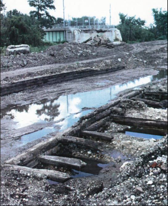
The route of the canal in Terre Haute deserves a closer look. Not only did Terre Haute have the most bridges, it also had some other interesting structural canal features. The canal water coming from the north was fed by damming creeks from Wea Creek in Tippecanoe County to Sugar Creek in Parke County, a total of 84 miles. The canal water coming from the south was fed by damming the Eel River and building a feeder that entered the main canal 20 miles above Terre Haute. At that point on the summit level water flowed in several directions. In addition to the normal flow north and south, some of this water was introduced into the Splunge Reservoir to the West via a weir. The water flowing northward passed Riley and then went on to downtown Terre Haute at Eagle and 1st street, where the waters spilled via another weir into the Wabash River. This location was at the termination of the 12 ½ mile nadir level of the canal that began in Parke County at Numa. The nadir level was where water flowing from 2 directions met and had to be diverted outside of the canal channel. Recently our Canal Society placed a sign at this location.
Why did the canal take a right angle turn in Terre Haute. The canal entering from the north was close to the Wabash River. The last lock adjustment was the 6 foot drop at Numa in Parke County. This began the nadir level into Terre Haute. The canal from the south was coming in from the 79 feet higher summit level, 20 miles away in Clay County. It took 9 locks to make this adjustment in elevation and the final step was a 19.5 foot drop at 2nd & Chestnut Streets very near the nadir spillway to the Wabash. It they extended the canal further south of downtown, it would have likely required another lock to lower the northern level, which was already 12 ½ miles long. The Wabash River after passing downtown Terre Haute turns southwest and would have required some modifications and an extension of the canal levels coming from the south. There were also some higher elevations south of town to contend with.

With canal features added in 2008 by Bob Schmidt. Copyright 2008 Canal Society of Indiana
As the Wabash & Erie Canal came into Terre Haute from the north it approached and followed the Wabash River. Pork houses were located along it. The canal itself never entered the river at this point. The Cross-Cut Canal waters were coming off the summit at Blue Hole and converged with the waters coming from the north in Parke County. When they met at the nadir level (lowest point) a culvert provided excess canal waters an outlet into the Wabash River. A large basin was located at this level. At the basin a towpath bridge was built for the towing animals to cross when the towpath changed to the opposite side of the canal. At the northern end of the bridges were needed in this town since the canal wound through it rather than along its side. Note the flow of the water coming off the summits to the nadir level.
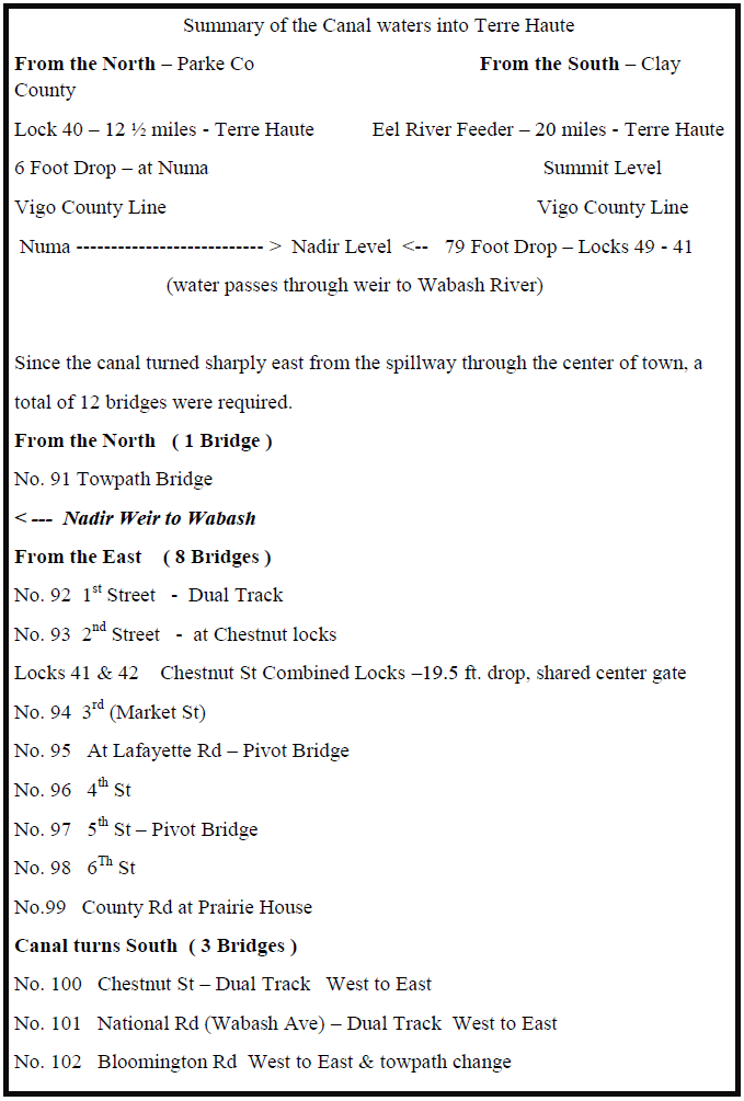
Coming from the north and just before reaching the nadir weir there was towpath bridge No. 91, which allowed the animals to turn away from the Wabash River side of the canal. At 1st St, there was bridge No. 92 that was built wide enough for two way travel. Next was a bridge No. 93 at 2nd and Chestnut streets at the foot of the locks. Locks No. 41 & 42 were unique structures in that they shared a common gate in the center. Together they provided the final drop of 19.5 feet to the nadir level.
Bridges No. 94 – 99 allowed the north south streets to cross the canal that ran due east. Note that bridges No. 95 & 97 were pivot bridges. At 9 ½ Street the canal turned due south. The next 2 bridges No. 100 & 101 were dual lanes at the East to West crossings of Chestnut St. and the National Road (Wabash Ave). The final Road bridge No. 102 was located at the Bloomington Road at the south end of town.
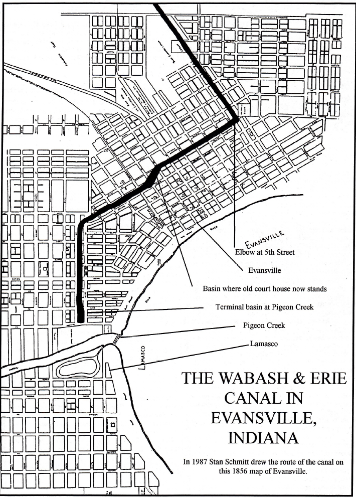
Another town with many bridges was Evansville. Although there was only a total of 8 miles of canal prism in Vanderburgh County there were 12 bridges — 9 of which were in that city. There were 3 more in the adjoining town of Lamasco, which in 1870 was annexed into Evansville. Again the canal ran through the center of the commercial district of Evansville and then dog legged into Lamasco.
From the attached chart there are some interesting observations One was that in Tippecanoe County in 1850, the city of Lafayette was the largest city in population along the W&E canal route, but only had 2 bridges. This was because the canal in Lafayette followed a linear route and was built very close to the Wabash River. Fountain County had many smaller towns along the Wabash River, but 38 miles of canal and 16 bridges. Parke County, which also had many small towns, only had 26 miles of canal, but had 15 bridges due to the many ferry crossings to the west along the Wabash River.

Remember that there were other bridges constructed by local communities. For more information on canal bridges see page 13 of the December 2015 issue of The Hoosier Packet, which may be found on this website or by clicking the button below.
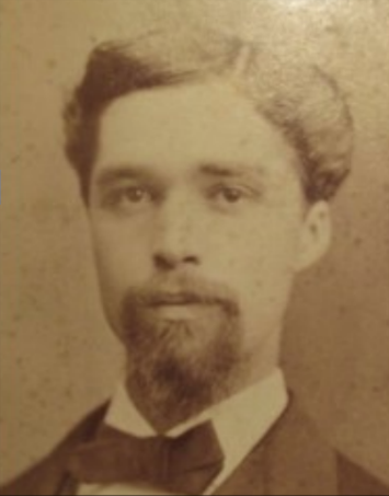
SAMUEL WILSON “JUDGE” PARKER:
His Life And Whitewater Canal Years
By Carolyn Schmidt
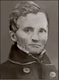
(Sept. 9, 1805—Feb. 1, 1859)
Find-A-Grave 9122305
Elizabeth Miller Parker gave birth to her first child, Samuel Wilson Parker, on September 9, 1805 near Watertown, Jefferson county, New York and named him for his father, Samuel Parker, who had passed away on August 2, 1805, a month before her baby’s birth. About March 1806 she married Joseph Wadley and had six more children, Sylvander, Charles, Maria, Caroline, Catherine and James Wadley, who were half brothers and sisters of Samuel W. Parker.
Around 1815 when Samuel was ten years old, he and the Wadley family moved to Cincinnati, Ohio. Three years later they moved to Oxford, Ohio. There Samuel attended school and finished his education at Miami University graduating at the head of his class in 1828. While at the university he was a member of the Miami chapter of Alpha Delta Phi Fraternity.
Shortly after his graduation, Samuel moved to Connersville, Indiana where in November 1828 he opened a private school and taught there for several terms. When the Connersville Seminary opened in 1829 Samuel was its president. He resigned from this position in April 1830 to work for the Connersville newspaper. During his teaching and newspaper years he spent his spare time studying law in the office of Oliver Hazard Smith. Samuel was admitted to the bar in August 1831 and practiced law in Connersville.
1834 was a busy year for Samuel. On July 16, 1834 he was married to Susannah B. Watton of Connersville. Samuel was 28 years of age and Susannah was 18. He also founded The Watchman, a Connersville newspaper that year and edited it until 1836.
In 1836-38 Samuel was appointed Prosecuting Attorney for the sixth Circuit Court of Indiana and in 1839 he was elected for another seven years. His salary was $150 and perquisites (something additional to regular profit or pay resulting from one’s position or employment).
After the passage of the Internal Improvements Bill in 1836, which provided for the White Water Valley Canal to extend from Hagerstown to Lawrenceburg with the sum of $1,400,000 appropriated for its completion, a celebration was held on the evening of January 18, 1836 in Connersville, Indiana. The Connersville courthouse was lighted from its basement to its steeple by lanterns. Samuel W. Parker and Oliver H. Smith addressed those gathered there and many toasts were drunk. The group then went to the river bank where bonfires blazed. At dusk the town’s cannon was hauled out to the canal line. Six shots were fired to honor the governor, the senator, one for each county representative at the General Assembly, and one to the Whitewater Valley Canal. Unfortunately a piece of artillery exploded prematurely leading to the death of Alexander Saxon and badly injuring Joseph Clark, Abiather Williams and Willian Worster.
On September 13, 1836 canal contracts were let at Brookville. Participating in the “ground breaking”
ceremony were Gov. Noah Noble, ex-Gov. James B. Ray, Dr. Drake of Cincinnati and George H. Dunn, Esq. of Lawrenceburg. One of them loosened the dirt with a pick for a few feet, another trundled the wheelbarrow along the future canal path, the third filled the wheelbarrow, and the Hon. David Wallace, the orator of the day, wheeled it off.
On December 15, 1837, the superintendent of canal construction reported that the Lawrenceburg-Brookville section was half completed by 975 men at the cost of $18 per month per man. December 20, 1838 this section was completed, but it was not until June 8, 1839 that the “Ben Franklin,” an old canal boat from Ohio’s Miami and Erie Canal, reached Brookville from Lawrenceburg.
In 1839 Samuel began his service in both branches of Indiana’s General Assembly. He was a member of the Indiana House of Representatives from 1839-40, the Indiana Senate from 1840-43, and in the 28th session of the Indiana House of Representatives in 1843.
Indiana completed the canal from the Ohio River to Brookville ($664,665) and about one half of the work between Brookville to Cambridge City by 1839. Unfortunately the state had to abandon all public works when its debts rose to $14,000,000. On August 19, 1839, the canal commissioners reported that the state was unable to spend another cent on its canals. The citizens found this financial collapse hard to believe. No work was done on the White Water Canal from the fall of 1839 until the summer of 1842.
The Indiana Legislature in its 1841-42 session sold the canal to Henry S. Valette, a wealthy man from Cincinnati, Ohio, and chartered the Whitewater Valley Company with $400,000. in capital stock. Samuel W. Parker and J. G. Marshall, then members of the Legislature, were active in securing the charter.
On July 28, 1842, over 10,000 persons attended a barbecue in Cambridge City to celebrate the commencement of operations by the canal company. Samuel W. Parker dug the first wheelbarrow of soil and gave a witty speech (his more formal address was never completed due to a huge thunderstorm) and the Hon. John T. Elliott of Newcastle dug the second.
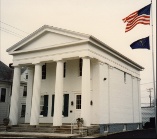
Photo by Bob Schmidt
The White Water Canal Company that was headquartered in Connersville acted under state charter from January 20, 1842 and had James Conwell as its first president. In 1843 the company purchased a building built in 1842 and began using it as its headquarters. It became known as the “Canal House.” Samuel Parker was elected its second president in 1843 but resigned in 1847 due to the contested election for the board of directors in (Two ticket factions arose at that time – the John Newman ticket and the Samuel Parker ticket. Newman prevailed and he was the third president for five years. His salary was set at $1,000.) In 1848 the ownership of the “Canal House” passed to Samuel W. Parker, president of the company, when the company had financial difficulties.
The White Water Canal was completed from Brookville to Laurel by October 1843. Another celebration took place with one hundred persons boarding “The Native” in Brookville at twelve noon with cannons booming, bands blaring and crowds shouting huzzas as the boat headed up the canal. It was delayed at Yellow Banks by a log raft that was jammed in the lock and arrived in Metamora two hours later. There the team of mules was replaced. However, the team broke the tow line and bolted off into the darkness below Laurel and “gallant gentlemen” had to tow the “Native” upstream into Laurel.
The following morning the tired party boarded the boat at ten o’clock and arrived at Metamora by one o’clock. But eight miles later they discovered the canal banks had slipped during the night and the canal was closed for repairs. They had to either walk or be transported by carriage to Brookville.
The canal was completed to Connersville by June 1845 and to Cambridge City by October 1845 at a cost of $473,000 to the company. The distance from Lawrenceburg to Cambridge City was sixty-eight miles.
Although Samuel W. Parker was often mentioned in Brookville’s newspaper, little was found of anything he wrote to the paper. In 1845, after citizens began questioning canal matters, Samuel wrote the following letter to the editor and in turn the editor wrote a column about the concerns. These articles addressed who was responsible for maintaining the bridges over the canal and why the canal company wasn’t receiving its own paper for tolls and water rents. The canal company had issued promissory notes to pay contractors and workers that circulated as cash since there was a lack of hard gold and silver currency. These notes had become so devalued that one dollar was only worth about 20 cents in merchandise. The company would no longer take the notes in payment and demanded real money. These show just a few of the many problems Parker faced as President of the canal company.
“MR. CLARKSON—Dear Sir: In the two last numbers of the “American” I find enquiries for information concerning matters interesting to your readers and involving the section of the White Water Valley Canal Company. Being called upon by name in one of the articles referred to, I address you this note.
“I have no authority from the Company to speak as to these matters, in their name —and must not be considered as so presuming to speak. But I have been with the Company, from first to last, in all things—think I understand their positions and views—and, anxious as I have always been, for the success of the great enterprise that brought the Company into existence—I am no less anxious that they have the good will of the public, and especially of the citizens of this valley. And I have the most abiding confidence, that all, who fully understand the attitude of the Company, will cordially yield them this good will. Those who do not understand, if they are honest, will wait, as you have, until they do before they condemn.
“The first enquiry is, whether the Company will repair and reconstruct the dilapidating “Canal Bridges” of Franklin county? If they do so in Franklin, they must in Dearborn, Fayette and Wayne, as a matter of course. Had the State retained the Canal, she would not have kept up the canal bridges—nor will she keep them up when she resumes the Canal—an event which I do not believe to be many years in the future—excepting those bridges on that part of the line within the limits of Ohio—these are to be kept up by special
compact, as a part of the consideration for the right of way granted by Ohio to Indiana.“It has not been, nor is it now, the policy or practice of the State to keep up the Road Bridges, any more than the Farm bridges, across her canals. And it is not understood that such is the policy or practice of any State in the Union, having Canals. In this behalf, I understand the charter of the Company, to place them, whilst they may retain the canal, where the State was, and will be—and that they cannot legitimately assume any other position.
“If the Company continue in use for “Change Bridges” such as are also designed for public travel—they ought to do a fair part in keeping them up—and I have no doubt they will.
“Should the proper authorities of Franklin or any other county, desire to test this question before the Courts—as now constituted, I am satisfied the Company will at any time promptly and fairly make an amicable case, that will determine the matter to the satisfaction of all who still feel that they owe allegiance to the laws of their country. And it cannot be doubted that such is the feeling of all the citizens of all the counties in this valley.
“The other enquiry is as to a rumor that the Company have determined to refuse their own circulation for Tolls and Water Rents after the 1st of Oct. next. I do not know the Rumor ever told the truth—certainly her mendacious reputation is retained in this instance.
“At the last session of the Board, after much , and anxious consideration, it was ordered that from and after the date aforesaid, all Toll Collectors be required to discount 30 per cent from the existing tariff of tolls, and require them to be paid in Bankable funds. Water Rents are unmolested, and I presume will be, from the fixed nature of the contracts. And let me suggest in those having such rents to pay, and desiring to pay the same in the circulation of the Company—they had better get those funds now, if they can—for they will find them scarcer than gold and costing as much within six months from this date. Very little more will be issued by the Company; and of the forty odd thousand dollars now out, full one half is already taken up by three men who will hold it up, and get as much more as they can until the Company is prepared to redeem the whole. And my opinion is, that the whole will be retired by the 1st of March next.”
“S.W. PARKER”
9-19-1845 Brookville American
“The Canal Co., &c.
“CONNERSVILLE, In., Sept. 19, 1845
The editor of the Brookville American responded to Parker’s letter as follows:
The Canal Company. —In another column will be found a clear and lucid exposition of the doings, intentions and position of the White Water Canal Company, by S. W. Parker, Esq. It will be read with profit by our readers.
“When we first received the news of the offer, refusing to take their own circulation for tolls, our feelings partook somewhat of that of the people generally. And had we at the time indulged in remarks in accordance with our feelings, we should have said some hard things. But in view of the great and lasting blessings this company had conferred upon the people of this valley —began and carried on amid pecuniary gloom and despondence, it is well to be slow in our reprehension. And notwithstanding we doubt the propriety, or even the honesty of the “order,” yet we are willing to let the matter go to the people without comment. There are strong and abiding prejudices in the public mined against corporations and companies, and we have found ourselves sometimes indulging toward them uncharitable thoughts. We are old enough to know better, and do better, but there is so much of human nature about us, that we have to be watchful.
“The position, which Mr. Parker supposes the Company will take relative to the Canal Bridges, is reasonable. Let the question be fairly tested by the Courts of the country, and if against the citizens of the county, we shall use all our influence to have them abide the laws peaceable and quietly. It will be a grievous burden upon us, and many of the bridges will necessarily have to be abandoned, and the roads changed. But we hope ever to find the citizens of the county obedient to the law, of their country.
“The people generally, boatmen, and shippers of produce, have no right to complain of the “order.” It is only the holders of the money — those who have received it in good faith as contractors and laborers. Of the amount in their hands, Mr. Parker is better able to judge than ourselves.”
9-19-1845 Brookville American
“CANAL DEBTORS. – All persons indebted to the White Water Valley Canal Company, on any account whatever, will be expected to pay by the 1st of June next. The Company have determined to close up all cases of the kind, as soon as possible. Further indulgence need not be expected. Delinquent Stock will be sold as provided by the Charter, to the highest bidder – and any deficit not supplied by such sale, will be collected from the subscriber, at once by due course of law.”
“S. W. PARKER, Attorney for the Co. April 13, 1846”
5-8-1846 Brookville American
The Whitewater Canal was originally to go as far as Hagerstown. When the Hagerstown merchants learned the Whitewater Valley Company was not going to build to canal to their town, they banded together and formed the Hagerstown Canal Company about 1846. Through their initiative the canal was completed from Cambridge City to Hagerstown in 1847.
In January of 1847, the aqueducts across Symon’s Creek near Cambridge City and across the West Fork of the Whitewater River at Laurel were washed out by a freshet. Huge channels were cut by the fast flowing water around the feeder dams at Cambridge, Connersville, Laurel, Brookville, Cases, and that at Harrison. The repairs were estimated at $90,000. Then once again in November 1848 a flood did another $80,000 in damages. The canal was repaired and operated for several years. Its total cost was reported in 1848 as $1,920,175.13, much more that the canal ever received in tolls during its years of operation. The last boat to pass through the entire canal (1849) was the “Union” owned by David McCarty.
Samuel W. Parker was not reelected President of the White Water Canal Company in 1847 according to the following article:
“Canal Election. – The annual election of Directors of the White Water Canal took place on Monday last. The old board was re-elected. We regret to learn that Samuel W. Parker’s place in the company has been given to Miles Murphy of Henry Co. . Mr. Parker has given life, energy, and credit to the company, and has made an efficient and popular President, and however active Mr., Murphy may be, he cannot expect to be as beneficial to the company. But Parker has a noble soul, and every good work will have his aid, counsel, and supports, no matter what station he may hold.
“We believe Mr. Parker would not consent to serve the company as President and attorney for the salary he received the past.”
1-8-1847 Brookville American
The Whitewater Canal was located in front of the fence.
Photo by Bob Schmidt
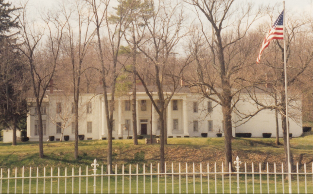
In 1850 Samuel purchased Elmhurst, sometimes called “Indiana’s Little Whitehouse,” for his
residence. It was built in 1831 by Oliver H. Smith, then Caleb B. Smith, Samuel’s brother-in law, took
up ownership, followed by James Shaw in 1838, and Nicholas Patterson in 1842. Samuel was the
first to remodel Elmhurst. He paneled the lower front rooms with solid cherry. He landscaped the
grounds planting dwarf Catalpas and other trees. He hung a bell by his front porch from which he could see canal boats passing over the Whitewater Canal that ran in front of his home. As canal boats passed by his residence on their way between Cambridge City and the Ohio River, their captains would toll their bells to salute “the boss,” Samuel Parker, and often he would ring his in return. To the rear of the house he dedicated the Parker cemetery where he built his family tombs of solid flagstones with brick lining the bottoms and gravel for drainage. He wished that his remains never be disturbed. In 1881 Elmhurst was sold to James H. Huston by Mrs. Susannah Parker.
Samuel’s first election to the House of Representatives of the 32nd United States Congress was in 1850. He represented the 4th district, which included Fayette, Union, Wayne and Henry counties in Indiana. Due to the 1850 Census there were 10 districts at the time of his first election and 11 at his second selection. By reelection he served from March 4, 1851-March 4, 1855. He declined to accept the renomination for a third term. He was the leader of the Whig party in Indiana for twenty years. He was constantly in demand as a campaign speaker throughout the country.
Returning to his Connersville practice of law, he also became one of seven directors for the Junction (Ohio and Indiana) Railroad in 1856. He became the president of that railroad. From then on until his death he divided his attention between the practice of law and his various railroad interests.
Samuel W. Parker died at his residence in Connersville, Indiana on February 1, 1859 of pneumonia after a short illness. He was only 53 years old. He was laid to rest in the Parker Cemetery in Connersville. The Fort Wayne Weekly Republican of February 9, 1859 carried a short obituary saying that he was a long distinguished citizen of Indiana. He was a “gentleman of fine talents; as a lawyer he stood high—as an orator he had but few superiors. His loss will be keenly felt all over the West.”
Samuel W. and Susannah B. (Watton) Parker’s Family
Samuel married Susannah Watton who had moved with her family of six sisters and two brothers from Dayton, Ohio to Connersville about 1821. Five children were born of this union: John Marshall Parker (1836-1854), Walter Scott Parker (1840-1862), Samuel B. Parker (1842-1863), Quincy A. Parker (1845-1901), and Preston W. Parker (1849-1850). Three of the children died between ages of 18-22, one died at about 1 year old, and only Quincy lived a full life for that time.
Susannah’s sister Elizabeth married Caleb B. Smith, a member of Congress for three terms and Secretary of the Interior under Abraham Lincoln. Smith served in the Legislature from 1833-40 and was Speaker of the House In 1835-36. Her sister Mary married Joseph Justice a druggist in Connersville. Her sister Letitia married Robert G. Hedrick and was his first wife. The fifth and sixth sisters were twins: Melissa marred James A. Wadley, a dry goods merchant, and Eliza, after Letitia had died, became the second wife of R.G. Hedrick. Susannah’s two brothers were William and George Watton.
Susannah passed away at age 87 at approximately 2 a.m. on April 2, 1903 in Indianapolis, Indiana surviving Samuel by 44 years. She was laid to rest in Parker Cemetery in Connersville, Indiana.
Bibliography
- Ancestry.com: Samuel Wilson Parker, Sussanah B. Watton Parker, Samuel Parker, Elizabeth Miller Wadley
- Articles found in the Brookville American about Samuel W. Parker, as given in the article.
- Barrows, Frederic Irving. “Samuel W. Parker” History of Fayette Ounty, Indiana: Her People, Industries and Institutions. Indianapolis, IN: B. F. Bowen & Company, Inc., 1917.
- Biennial Report of Union B. Hunt, Secretary of State of the State of Indiana, For the Two Years Ending October 31, 1902, Indianapolis, IN: Wm. B. Burford, Contractor for State Printing and Binding, 1902.
- Catalogue of the Alpha Delta Phi. New York, NY: Executive Council of Alpha Delta Phi Fraternity, 1899.
- Find-A-Grave: Samuel Wilson Parker, Sussanah B. Watton Parker
- Fox, Henry Clay Memoirs of Wayne County and the City of Richmond, Indiana. Madison, WI: Western Historical Association, 1912.
- History of Historic Elmhurst. Connersville, IN: Werking Printing Company.
- Schmidt, Carolyn I. Whitewater Canal: Connersville-Yellow Bank. Fort Wayne, IN: Canal Society of Indiana, 2012.
- Schmidt, Carolyn I. Whitewater Canal in Wayne County, Indiana. Fort Wayne, IN: Canal Society of Indiana. 2010.
- Walters, “Canal House Restored.” Making of Connersville and Fayette County. Vol. 1:20-127.
- Young, Andrew W. “Samuel W. Parker” History of Wayne County, Indiana. Cincinnati, OH: Robert Clarke & Co. Printers, 1872.
Vanished Canal Life Returns In More Bash Interviews
Part 2
By Margaret Griffin
F. W. Bash
Copied and published by Jean Gernand
When longtime teacher and historian Jean Gernand published 922 pages of Frank Bash’s newspaper columns, she did a wonderful thing. She made available many, many first person accounts of pioneer life in one volume. This is the second gleaning from Bash’s interviews with senior citizens of the 1920s.
Most of the people spoke of their childhoods in Huntington County, also telling things their parents had told them about the first days of the Wabash and Erie Canal.
In 1921, Henry Kautz, 91, said that his father saw hundreds of men digging the canal. He walked from Mt. Etna to the land office in Fort Wayne, and moved his family to Indiana in 1840.
In 1925 Bash talked with Samuel F. Winter, a former colleague then past 90. Winter had been editor of the Huntington Democrat and Peru Chronicle newspapers. Winter said he ate his first lunch in Huntington County at the canal lock in Roanoke in November 1855. Navigation had almost closed for the season; packets were stopped but local cargoes still moving. A boat captain was persuaded to take him into Huntington.
Bartholomew Grayston
(12 May 1850—19 Jun 1940)
Find-A-Grave #73443633
Also in 1925, Bash interviewed Dr. H.B. Grayston, a prominent citizen of Huntington, who remembered three high bridges spanning Jefferson, Warren and LaFontaine Streets. People would come from miles to watch the swing bridges operate. There were accidents at the bridges: one man was drowned and another woman fell into the water, parachuted by her hoop skirts. A chain of men organized to get her out, but the chain broke and the one closest managed to hook the hoop and pull her in.
Grayston reminisced about Charley Thorne’s boat yard on East Tipton Street. It employed a “large force” of men, and Grayston could still see Thorne directing them and laying out each detail of the plans for a new craft. He saw heavy ribs and long timbers lying in wait.
Among the next year’s interviews was with Charles Bechtol, 86, who came to Indiana in 1856 and added more details about the Thorne boat yard where he worked in the winter of 1861. There was room enough for five boats to dry dock at a time, measuring 85 feet long and “about” 10 feet wide. On the day when a boat was launched, news spread and a crowd gathered. Skids were soaped, blocks removed and the boat slid sideways into the canal. Boats were named by their owners, for example, Mr. Cheesbro called his “The Thames.”
(3 Sept 1840—? ? 1932)
Find-A-Grave #73729359
Bechtol went on to say that he worked as a pilot for Mr. Cheesbro, handling the steering stick, for four summers. He made $40 per month at first, including board. They delivered hoop poles to Cincinnati, going east to the Wabash & Miami Canal, and then south to the Ohio River. Once when the freighter had a load of flaxseed, the captain docked at an old pier to pay a toll. The boat stuck in the muck and collided with the pier, which split the hull. Although seed poured into the cabin it did not go in the water. The captain yelled at Bechtol; the young man yelled back that he just was following the captain’s orders to dock.
Twice he saved a captain’s life. At Toledo in deep water the captain’s legs caught in the rope as it was tightening. Bechtol cut the line just in time to save him from drowning. Another time, during a cold snap, they were using two teams of horses to pull the boat when sagging lines knocked the captain overboard. He bobbed up, grabbed a piece of ice and Bechtol threw him a line.
Also in 1926 Bash talked with William Reemer. As a boy Reemer was paid $20 per month to drive mules on the towpath for Captain Sile Welch. They picked up walnut lumber at Lagro and took it to Toledo. Other loads included wagon spokes. Close to Raccoon Village on the canal, a sudden lightning storm scared him, he told the captain he was done for good, and ran home. (William H. Reemer 2 Oct 1849—7 May 1927 Find-A-Grave #9719821)
Apparently 1926 was a good year for remembering the Wabash and Erie Canal. Bash printed his interview with Tom Cunningham, whose father worked with the state boat crew repairing leaks and breaks. Cunningham remembered a string of log rafts a mile long floating in the canal, going off to market.
In Bash’s articles were stories about horses and mules, the power behind canal boats. One man rescinded the notion that mules were docile. “The only place I’d stand at a mule’s funeral is at the head of the coffin,” he chuckled. A legendary horse named Anthony could jump any split rail fence but one, which his owner put around his grave in the woods.
There are more stories about the longest canal in America in Frank Bash’s string book, which will be seen in The Tumble.
W & E Canal Grocery Order
Bit by bit we piece together Indiana’s canal history. An article in the “Between the Lines” column by G. L. C. was found in the December 7, 1978 Daily Clintonian by CSI member Berky Davis of Rosedale, Indiana. It gives us information about how much it cost to feed canal workers.
“I guess you wouldn’t mind paying five cents a dozen for eggs, providing they were large and fresh. Still, I expect that was a rather high price in May of 1854 for they were bought to help feed workers on the Wabash and Erie Canal.
“As you will recall, that was a rather wasteful project and helping finance it put Indiana so far in debt that it resulted in a constitutional amendment which prohibits the state from again incurring bonded indebtedness.
“The bargain eggs were just a few of the items that seem cheap today, which appeared on a shopping list of James Johnson, who apparently had a contract for feeding some of the canal workers. The list bears the date of May 18, 1854.
“Ezra Curry, of Clinton, now retired has had the old list since 1926 when as a young tinsmith and heating expert, he found it behind a mantle which he had removed from an old house.
“Along with the list, Ez tells me, he also found a letter informing someone that government inspectors were coming soon to check on progress of the canal construction and to have everything in order. As nearly as Curry can recall, he loaned the letter to someone who never brought it back.
“At that time, somewhere around where Lyford is today, there was a little settlement called Hudnut and there were a set of canal locks there but all traces of them seem to have disappeared long ago.
“But to get back to Ezra’s shopping list. It is very badly time-stained and some of it is almost impossible to read, but it seems to have been dated at Howard, Indiana, May 18, 1854. The town may not be correct. It is almost illegible. It recites that James Johnson bought of J. P. & I.C. Grimes articles for state bond. Presumably they were paid for with one of the bonds that broke Indiana.
“Several different purchases were included on the long list the first of which dated back to March 13 of that year. This listed five pounds of butter at 10 cents a pound, a smoothing iron at 40 cents and a wash tub at $1.00. Thirty dozen eggs were charged at $1.50.
“The men must have liked eggs for there were two charges in April, one of 10 dozen and one of 26 dozen, still at five cents a dozen. This bill included a bushel each of oats at 35 cents and corn at 35 cents.
“Time after time eggs and butter are listed, always at five cents a dozen for the eggs and 10 cents a pound for the butter. Johnson also bought six bushels of potatoes at one time which cost 25 cents a bushel.
“The whole bill, which included some nails and rosin, came to $17.50.”
The photograph of the bill attached with the article is barely legible. It was signed by Hon. J. G. Ewing
As to the freshness of the eggs. During canal days eggs would be put into barrels with a layer of straw at the bottom of the barrel and straw between each layers of eggs. How long would it take to fill a barrel of eggs? Then the eggs would probably be used from the top of the barrel to the bottom of it. Can you imagine how old the eggs at the bottom of the barrel would be before they were used? Also, during the summer the eggs would get very hot and during the winter very cold? How did these temperature changes affect them? What kept the butter from melting?
Oh, to live in canal times! I think not.
Many Hands Help Signage
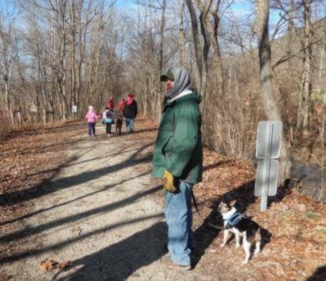
A good example of CSI members working together to accomplish a task can be seen with the placement of a sign marking the remaining prism of the Wabash & Erie Canal located at the corner of Redding Road and Aboite Road, across from Jesse Vermilyea’s home west of Fort Wayne, Indiana and near the Aboite Creek Aqueduct site. (Vermilyea was a contractor on the canal and had mail delivered by canal boat to his home to distribute to the neighboring community.)
A suggested location for sign placement was marked.
Photo by Emily Boller
Tom Castaldi, CSI director from Fort Wayne, contacted Kurt and Emily Boller about placing a CSI sign on their property. After they agreed Bob Schmidt, CSI president, ordered the sign from CDS Signs in Sharonville, Ohio. During the CSI fall tour a CSI sign was seen that Terry Bodine, CSI director from Covington, Indiana, had made with a canal boat cut-out placed over the sign near the canal prism. Terry mentioned that he had an old board at home on which he had traced the boat design and he would give it to the society to put above another sign. Ed Powers, CSI member from Roanoke, said he could cut it out. Bob Schmidt picked up the board following the tour and gave it to Ed to cut out and sand the boat. Ed returned the cut-out to Bob, who painted it and had it ready to go when the CSI sign was finished. In the meantime Tom went to the Boller property and marked where he suggested the sign be placed. Bob then picked up the sign in Sharonville and delivered it to Tom, who in turn delivered it to the Bollers. They installed the sign on November 18, 2023.
Tom gave the Bollers a membership in CSI and Bob delivered a new membership packet to them. Shortly thereafter CSI received the following letter from Emily.
Thank you for the canal poster and package (including Christmas ornament!) from the CSI.
I’ve been posting information on Facebook, so hopefully, even more people will become educated about the canal systems in Indiana.
My husband Kurt and I installed the sign on Saturday (thankful for nice weather). We moved the location west of your suggested spot due to there being less cinders there from the interurban tracks.
The current owners of the Vermilyea House are now inspired to dig their historical sign out of their barn, restore it, and install it along Redding Road again. There have been no historical markers out here since the late 1990s or early 2000s.
We are happy to be a part of history!
Emily Boller
New Sign To Mark Canal Timbers
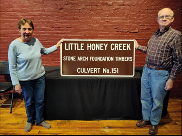
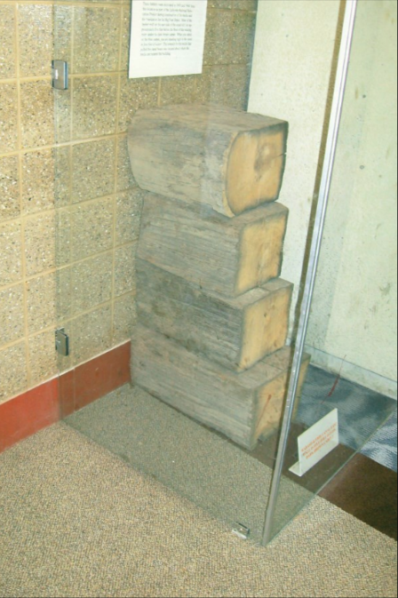
After their presentation to over 1000 students at Vigo County Parks & Recreation’s Mini Pioneer Days in Terre Haute’s Fowler Park last September, Sam and Jo Ligget requested that a CSI sign be placed by the exhibit of foundation timbers from Culvert #151 that carried the Wabash & Erie Canal over Little Honey Creek. The sign arrived in November. They are working with the park department to have it erected and to plan a dedication program for the sign. See article in the January issue of “The Tumble” for further information on Mini Pioneer Days.
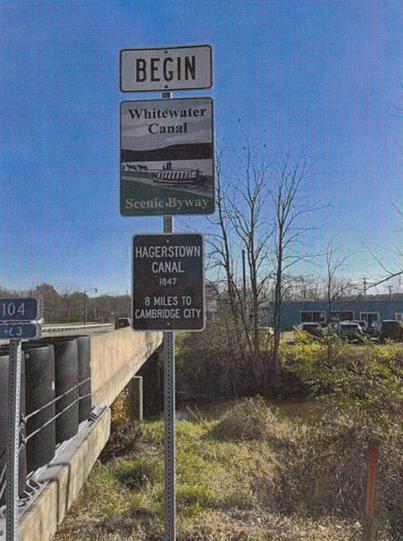
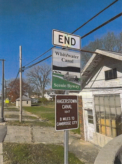
Jerry Mattheis Memorial Signs Erected
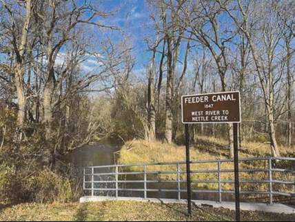
After CSI director Jerry Mattheis of Cambridge City passed away on January 15, 2023, CSI headquarters received funds for purchase of CSI signs in his memory from several CSI members. The following three signs have been erected for the Hagerstown Canal and its feeder. Photos taken by his wife, CSI director, Phyllis Mattheis.
The Feeder Canal sign is located on Teetor Road bridge looking north 4 blocks to Main Street at S E Part of Hagerstown. Canal boats turned around at Nettle Creek canal basin.
Smaller signs were placed beneath Whitewater Canal Scenic Byway signs.
This picture to the left was taken looking east at Main Street Bridge in Hagerstown on the south side of SR 38.
This picture to the right was taken from the same bridge looking west on the north side of SR 38.
1.9 Million Grant For Riley Trail Project
On Wednesday December 20, 2023 Indiana Governor Eric Holcomb and the Indiana Department of Natural Resources announced the Riley Trail project in Vigo County will get a state grant of more than $1.9 million according to an article in the Terre Haute Tribune-Star of the same date.
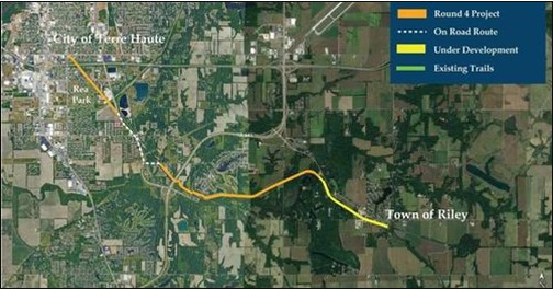
The grant is one of 14 given to communities in the fourth round of Indiana’s Next Level Trails program. The Riley Trail from the town of Riley to Terre Haute will be paved and be along a recent railroad corridor. It is estimated to cost $3,310,978 with the state actually funding $1,946,901.
The grant was announced Wednesday in La Crosse by Gov. Eric Holcomb and the Indiana Department of Natural Resources. This marks the fourth round of the state’s Next Level Trails program. In this round, 14 communities will receive a combined $31.2 million for 28 miles of new trail, the governor said in a news release.
Riley trail will receive $1,946,901; the total project cost is estimated at $3,310,978. The project will build a 7.9 asphalt paved multi-use trail from the town of Riley to the city of Terre Haute along a recently yielded railroad corridor.
Vigo county’s news release describes the route of the trail as follows:
The 7.9-mile asphalt trail will begin in the town of Riley, located in the southwest corridor, and will extend further west as it heads toward Terre Haute.
Leaving Riley, the Riley Spur Rail Line runs adjacent to State Road 46 before continuing past Lama Road.
From there, the trail will extend further passing the Idle Creek area and neighborhood.
After Idle Creek, the Riley Trail will run parallel to McDaniel Road before heading into Terre Haute. (The Wabash & Erie Canal also parallels McDaniel Road at this point.)
After its extension through the southeast side of Terre Haute, the Riley Trail will move towards Rea Park, where it will extend into a loop around the area, enveloping the golf courses, park area, and historic clubhouse.
The trail will continue to move further into Terre Haute through grassy areas before it extends under I-70 and ends at Margaret Drive.
It also says the the trail will be comprised of hot-mix asphalt 10 feet wide with 2 feet of recovery on each side to comply with the Next Level Trails program’s standards and to create an ADA accessible trail.
The trail will include pedestrian bridges and trail crossings. This will ensure that the trail is up to ADA standards and allows all individuals to access and use it safely.
Vigo county is currently in the process of completing design and engineering plans for the final trail design. It will work together with the city on remaining designs.
The program requires a minimum 20% project match. This may be achieved through monetary contributions, land value, and in-kind donations of materials and labor.
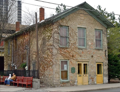
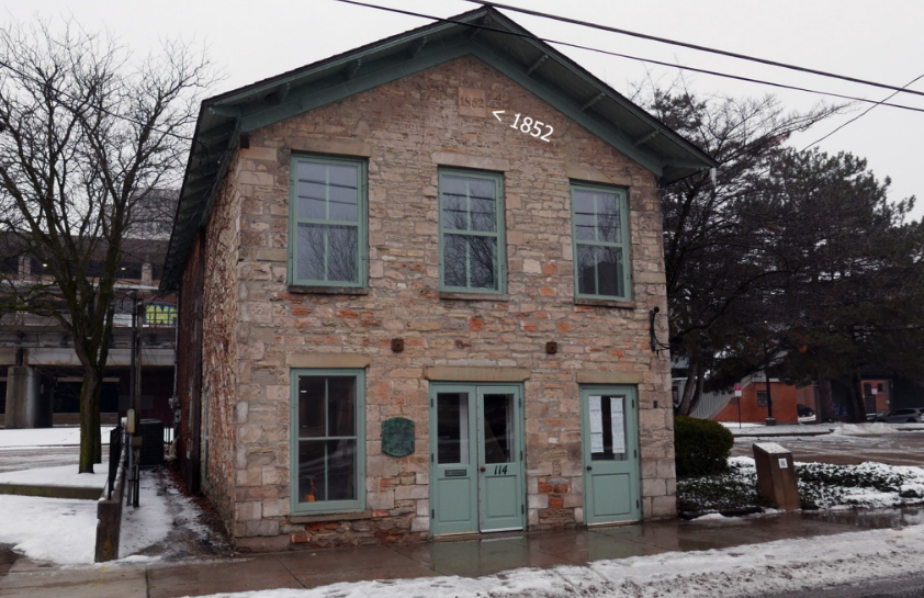
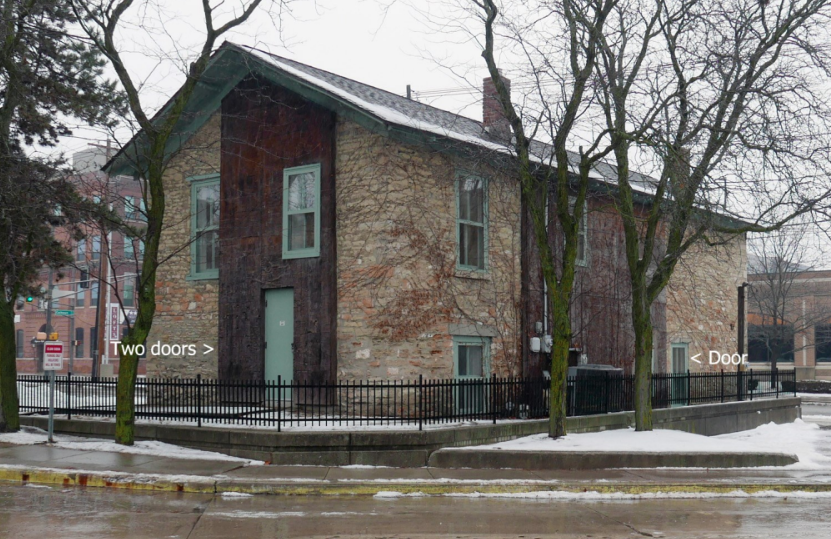
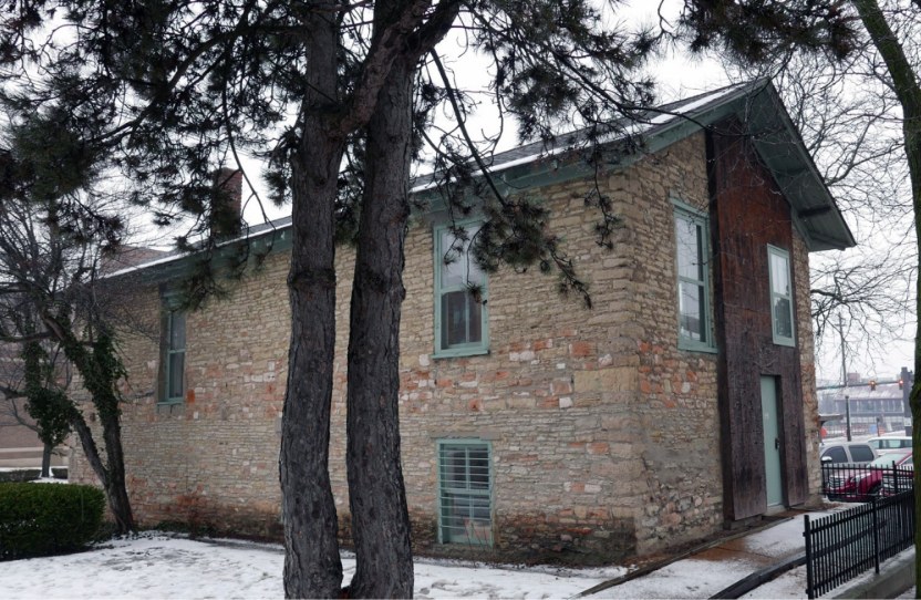
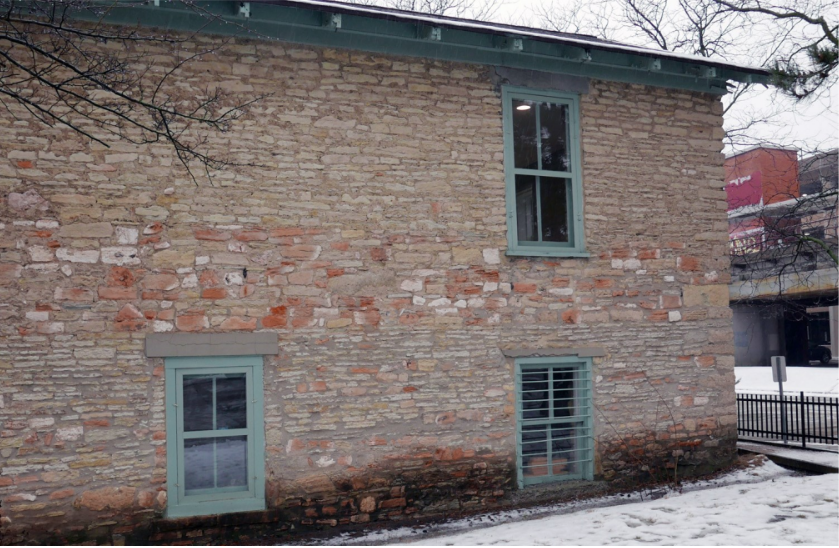
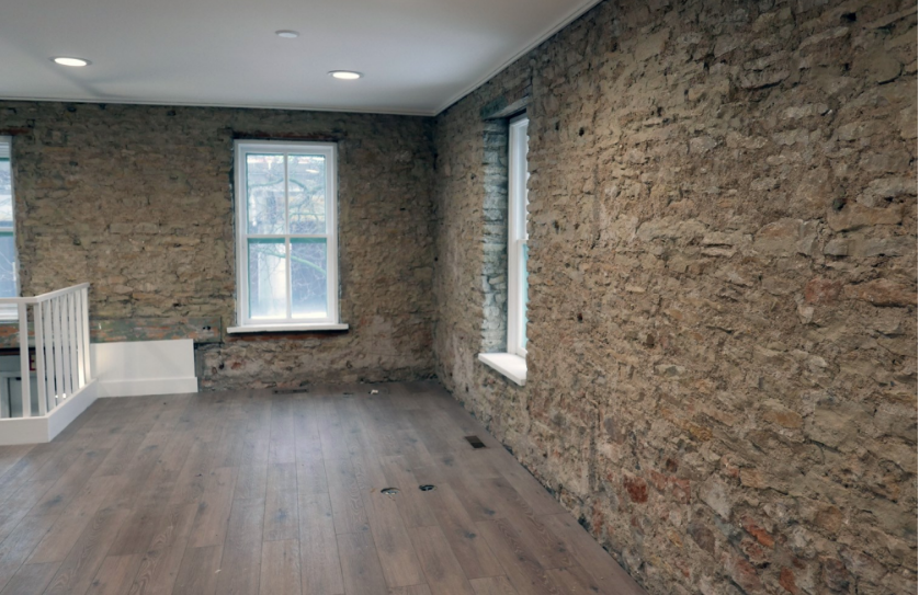
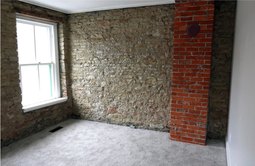
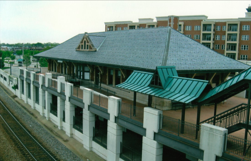
Ft. Wayne’s Canal House Restored
By Carolyn Schmidt
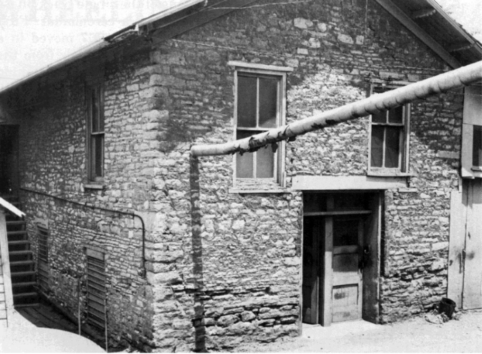
The Canal House Story: A Cross Section of Life in Fort Wayne During the Wabash-Erie Canal Era written in 1977 by John E. Loveland tells the early history of the “Canal House” and John Brown as follows:
1852-1862
On April 4, 1852 John Brown was deeded Lot 22, the property on which the “Canal House” was built, from prominent merchants, Robert W. and Elizabeth Townley and Jonas W. Townley. On this land, which is adjacent to the north bank of the Wabash-Erie Canal facing what is now Superior Street and about hundred feet from the southeast corner of Calhoun and Superior Streets, Brown built a structure for his business of randomly cut native stone that stands 22 feet by 50 feet and fronts on Superior Street. Above its entrance is a stone block with the date 1852 carved into it. He painted his name J. BROWN over this entrance’s lintel. The stone used in the building was probably quarried in Huntington and shipped by canal boat to Ft. Wayne. (The rear of the Canal House was later raised to meet the raised railroad grade at the back door.)
Brown announced his building was open for business in July 1852 by placing the following advertisement in issues of Fort Wayne Times And Peoples Press and in the Sentinel of Fort Wayne:
JOHN BROWN Dealer in Stone and Lime. NEW YORK AND LOUISVILLE
CEMENT AND PLASTER OF PARIS:
The above articles kept constantly on hand and for sale at his new stone building North of the Canal and near City Mills.
John Loveland found that the census of 1850 included the names of all of John Brown’s family:
| Name | Age | Gender | Birth Place | Occupational Value |
| John | 28 | Male | Glasgow, Scotland | Stone Cutter $600 |
| Mary | 33 | Female | Glasgow, Scotland | |
| Elizabeth | 24 | Female | Glasgow, Scotland | |
| Jane | 8 | Female | Glasgow, Scotland |
Loveland found an advertisement that showed Brown had been a business partner of tombstone sales with James Humphrey in 1847, before Brown built the Canal House.
MARBLE TOMBSTONES The subscribers have on hand a large lot of Marble Tombstones….Monuments and all kinds of work in their line. We keep always a stock of stone on hand for caps, sills, and other building purposes and stone work of all kinds on reasonable terms. Shop on the Canal West of Ewing’s warehouse. Orders from a distance promptly attended to. JAMES HUMPHERY, JOHN BROWN
A letter written in 1951 by Brown’s niece stated that Brown and his family lived on the northeast corner of West Berry and Jackson Streets and that the Canal House was his office.
Brown conducted business in the Canal House until his sister, Elizabeth, died in Fort Wayne in October 1852. In the winter 1853 he returned to Scotland for a year. In early 1854 he came back to Fort Wayne accompanied by his half-sister, Maria Rankin Brown, age 18.
The Canal House often housed itinerant deck hands and roustabouts during the winter season when the canal was not in operation. They lodged in the upstairs rooms and worked for Brown.
Brown continued in his stone cutting business until he sold the Canal House in 1862. It had been “an ideal spot to receive boatloads of stone and other materials needed in his growing contracting ventures,” according to Loveland.
1862-1885
Michael Hawfield’s article “Seeing Our Past Via the Canal House Door” in the September 10, 1983 issue of the News-Sentinal of Fort Wayne said that in 1862 Brown sold the Canal House to Henry Drover, who used it as a warehouse for his spoke factory and quarry interests.
Hawfield also says that in the 1870s the Canal House housed the Homeyer family on the second floor and the Borgmans on the first floor. William Homeyer was a crewman on a canal barge captained by his uncle Fred Brase. Christian Borgman was the captain of the “Coral.” Both men liked the location of the Canal House since they could tie up their boats at the rear of the building. But by this time canal traffic was down to only local transport.
James Shoemaker purchased the property from Drover’s descendants. The last private owner was William B. Howard from Illinois.
Craig Berndt, CSI member from Fort Wayne who led the latest restoration planners of the Canal House, provided the following information:
1881
A New York, Chicago & St. Louis Railway (the “Nickel Plate Road”) predecessor purchased 56 miles of the canal, extending from the Indiana-Ohio State Line to Lagro, Indiana. The Nickel Plate proposed construction of two mainlines from a point west of Ft. Wayne to Chicago and St. Louis, and, had it constructed the St. Louis line, it would have used some or all of the Fort Wayne-Largo section of the Wabash & Erie Canal.
1882
The Nickel Plate built six miles of track on the canal towpath, from the west side of New Haven, Indiana to Rumsey Street in west Fort Wayne.
1885
William B. Howard sold the Canal House to the New York, Chicago & St. Louis Railroad (Nickel Plate).
1885 – 1970
The “Nickel Plate Road” initially used it as a freight storehouse. Sometime later it was converted to train crew quarters. During its railroad years, the inside stairway was removed, three chimneys torn down, a new entrance installed, and the main floor made into two levels. Steam heat was installed when it was the boarding house for the train crews. Later the property was owned by the Norfolk & Western Railroad, which gifted it to the city of Fort Wayne in 1970.
1970 – Present
The City of Fort Wayne owned the Canal House.
1975 – 1976
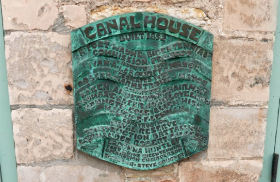
placed this plaque on the front wall of the
Canal House restoration project.
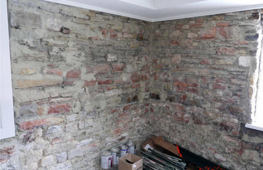
The Canal House was adopted for Fort Wayne’s 1976 Bicentennial Celebration by the Fort Wayne National Bicentennial Commission. They converted it to office space through the help of Detachment 0726 of the Naval Reserve Construction Battalion. The 25 Seabees worked two weekends per month to restore the exterior of the building to its original condition. The chimneys, called “chimleys” in canal boat time, were rebuilt and the cedar shingle roof restored with a $700 grant from Bird and Son of East Walpole, Massachusetts, manufacturers of building materials and machinery. Six hundred old bricks for the chimneys were cleaned and sorted by Boy Scout Troop 24 from rubble of the demolition of the Fort Wayne State Hospital and Training Center. The bricks had the necessary patina of age. The mortar was color-toned to fill the cracks in the stone walls.
The interior plastering, partitions, and steam head were removed and a modern heating system installed. Every window was replaced and custom made to fit the openings.
1976 – 1987
From 1976-1987, the offices of the Ft. Wayne Fine Arts Foundation (later Arts United) were in the Canal House.
1987 – 2021
The building sat vacant for thirty years. However, its importance to Ft. Wayne’s history was not forgotten. In late 1997 it was placed on the National Register of Historic Places as #97001542.
1998
The News-Sentinel of Fort Wayne reported on January 8, 1998:
Ft. Wayne, IN
National Register of Historic Places project #97001542
“A 146-year-old stone warehouse built in 1852 has been listed on the National Register of Historic Places.
“The building is now occupied by Arts United of Greater Fort Wayne.
John Brown, a Scottish immigrant who established a stone masonry
business in Fort Wayne, built the dwelling in 1852, on the old Wabash
and Erie Canal.“The designation means the federal government recognizes the site as
significant to local, state or national history.“Because Arts United is a non-profit organization, it is eligible to apply
for federal grants to restore the building.”
2021 – Present
Craig Burndt notified CSI headquarters as follows:
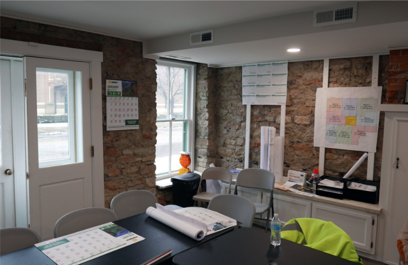
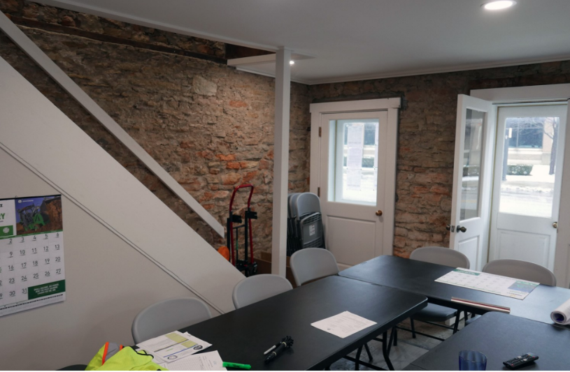
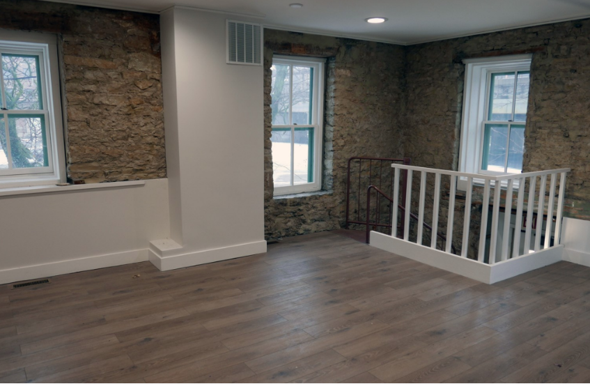
“Barrett & Stokely built the multi-use apartment building at Prominade Park and are now building the one at Club Soda. The city of Ft. Wayne let them use the Canal House as their construction office in exchange for them restoring its interior. I was just told that they have restored it.
“Their construction manager is still in the building. The Redevelopment Department will lease it to someone after B & S is gone.
“Its an altogether great building that will look fine, but not like it did as John Brown’s warehouse for stone, with the canal out the back door in the mid-1800s.”
We asked Craig if he would document this article with pictures. He took the following photos on January 24, 2024 and sent them with descriptions as the Canal House is readied to be occupied once again.


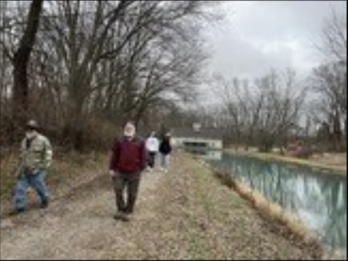
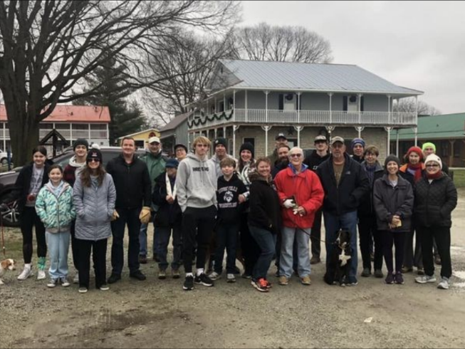
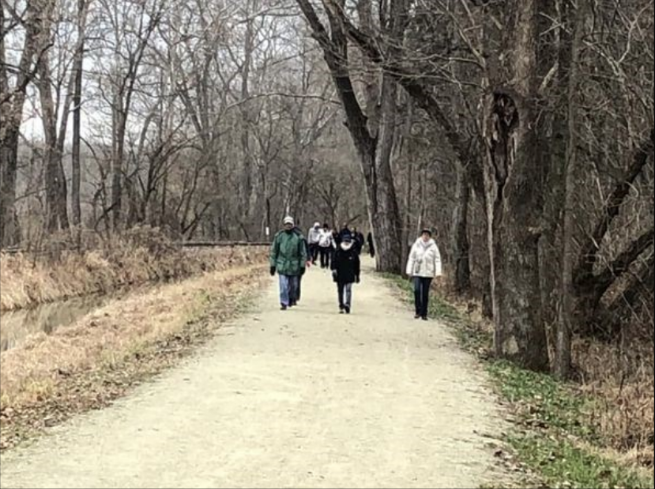
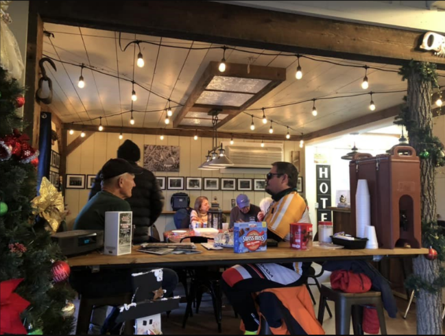
Canal Hikes Start New Year Off Right
Carroll County’s Wabash & Erie Canal Park had so many walkers arrive for its traditional “Day After
Christmas Walk” that they had to be divided into two groups. David McCain highlighted the natural wonder of the trails noting plant and animal inhabitants of the canal’s ecosystem. Carl Seese shared the historical significance of Canal Park landmarks such as the old railroad depot and the replica guard lock gates at the south end of the park. Afterwards hikers were treated to hot cocoa, coffee and tea at the Interpretive Center.
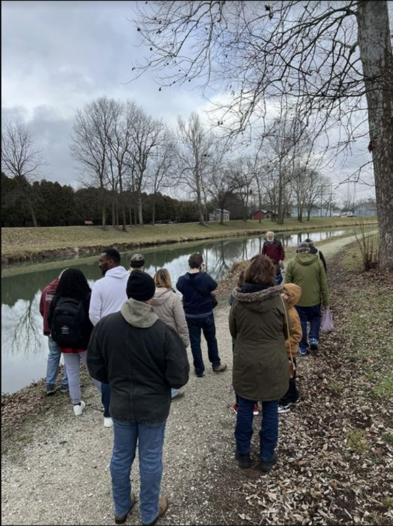
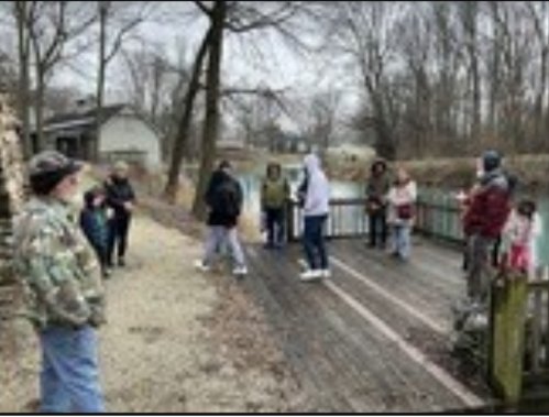
Photos courtesy Wabash & Erie Canal FaceBook and online “Currents”
Whitewater Canal Trails held their annual “Walk/bike of the Holidays” on New Year’s Day. They assembled near the old mill in Metamora before traveling down the towpath of the Whitewater Canal. They then were treated of pizza at Third Place Metamora. Terry Duffy baked the pizzas.


Photos courtesy Whitewater Canal Trails’ post on FaceBook and Gail Ginther’s FaceBook post.
Last two photos of Whitewater Canal Trail by Gail Ginther
Not so fortunate was the Heritage Park District in holding their “Lockkeeper’s Hike” in New Bremen, Ohio on January 14, 2024. It had to be cancelled due to severe temperatures forecast for that Sunday.

Linked Together
“Currents,” Carroll County’s Wabash & Erie Canal (CCW&E) on-line publication, recently carried an article about the Canal Society of Indiana, its website, educational events, and membership. They now have their publication linked to our website. CSI thanks them for this linkage.
CSI is linked to their site through our webpage. Click on Sites to Visit, Indiana Canal Sites, Wabash & Erie Canal, Delphi—Carroll Co. W & E Association —Website.
CCWEC Dues Levels Announced
CCWEC is celebrating its 50th Anniversary in 2024 and have announced its new dues levels.
Hoggee (donations under $149)
Steersman ($150-$299)
Lockmaster ($300-$467)
468 Mile Club ($468+)
Each level has increasing benefits for supporters
Their mission: Preservation, Education, & Recreation
John Purdue’s Connections to the W & E Canal
Purdue University was named for John Purdue, a multi-millionaire in the dry goods wholesale business. His business was the first business block in Lafayette in 1845 and was located just near the Wabash & Erie Canal, which was of great benefit to his business. He gave generously to his community. He donated $150,000 to found the land grant school in Lafayette that was to be named for him “Purdue.”
WREC Canal Article
By Carolyn Schmidt
Wabash River Enhancement Corporation (WREC) at Lafayette, Indiana had an article on FaceBook about the Wabash & Erie Canal, when it was built, where it was built, its connection between the Great Lakes and the Ohio River, listed the major imports and exports on the canal, and its transportation for residents. It went on to say the canal system in Lafayette was abandoned in 1874.
The article talked about the excavation of portions of the canal in Lafayette in the late 1990s for the railroad relocation. One of the pictures in the article showed the canal and wharf in Lafayette with a canal boat sketch in the canal prism and a sketch of towing animals where the towpath was once located. Another showed the “Delphi” in the canal in Delphi’s Canal Park and encouraged readers to visit the park.
Note: These photos were not with the article. They are from CSI picture files and are used to show what was mentioned in the article.
Road bridge now a pedestrian bridge
Towpath
Canal Prism
Canal Wharf
railroad location. A portion of it is over the canal
prism.

Gary Michael Ferris
Gary Michael Ferris, CSI member from Fort Wayne, Indiana passed away on November 26, 2023, at the age of 77 due to complications from a recent surgery. He was born in Auburn, Indiana on June 30, 1946 to Doyne and Mary Ferris. He served in the U.S. Air Force and had fond memories of his days stationed in England during the 1960s.
A resident of Fort Wayne for most of his life, he worked for Slater Steel as a Union Steward for many years. He also coached PAL Football and was a member of several organizations including the Auburn Shifters, Canal Society of Indiana, Civil War Round Table, and for 25 years the Fort Wayne Street Rod Association.
Gary was a kid at heart. He loved trains and owned Whistle Stop Toy Trains. He purchased the shop in 1997 from Gary Mertz and Jim Bert and relocated it as his home on Ernst Road east of I-69 in 1998. He drove the train at the Fort Wayne Children’s Zoo. He also loved his 1930s Chevy that he restored from a wreck many years ago. He loved taking Cassandra on long drives in his “Big Machine.”
During COVID, CSI ran an article about International Picnic Day and asked members to have a picnic at home or somewhere safe and send their photos to CSI headquarters to be published in the September 2020 issue of “The Tumble.” Gary and Cassandra participated. They had a picnic in
their backyard and submitted their photo.
Gary was preceded in death by his parents and his brothers, Stave and David Ferris. He is survived by his wife of 21 years, Cassandra; sons, Scott Ferris and Michael (Crystal) Ferris; grandchildren Gatlin, Cadence and Carson; sisters, Kathy (Joe) Wetmore and Christina Ferris; step-son, Dr. Kevin (Amy) Bower, step-grandchildren, Grace and Rose; and many nieces and nephews.
A funeral service was held on Sunday, December 3, 2023 at 2 p.m. at the D. O. McComb & Sons Funeral Homes-Lakeside Park (1140 Lake Ave., Fort Wayne, IN 46805). Interment was in Hoverstock Cemetery, Zanesville, Indiana.
Suggested memorials: Fox Island Alliance, 7324 Yohne Road, Fort Wayne, IN 46809; Little River Wetlands Project, 5000 Smith Road, Fort Wayne, IN 46804’ or The Shepherd’s House, 519 Tennessee Avenue, Fort Wayne, IN 46805.
Roger “Steve” Simerman
Find-A-Grave #264022451
“Steve” Simerman, husband of Canal Society of Indiana (CSI) Secretary Sue Simerman, passed away on February 10, 2024 at the Cleveland Clinic with his family around him. He was born on February 2, 1945 to Robert and Mary Belle (Hodson) Simerman in Allen county, Indiana and died shortly after his 79th birthday.
Steve grew up in rural Ossian, Indiana on his family’s farm and loved to work with mechanical things, especially Oliver Tractors.. He was graduated from Ossian High School in 1963, went into the Indiana Air National Guard at Fort Wayne and served his country from 1963-69. During this time he married Sue Nycum on August 19, 1967. Over time they had three children. After leaving the “Guard” has worked for Fort Wayne Leasing, Ryder Truck Leasing and Super Value in Fort Wayne where he used his mechanical skills. He was also a life long farmer in Allen and Wells counties in Indiana.
Steve was a member of the Canal Society of Indiana and the Northeastern Indiana Civil War Roundtable. He and Sue attended many CSI tours, symposiums and board of directors’ meetings. He always had a big smile while telling stories that were enjoyed by his friends as well as his family.
at CSI’s 40th Anniversary Celebration in Logansport, IN in 2022.
Photo by Bob Schmidt
He is survived by his wife, Sue; sons Robin (Michele) Simerman and Ron (Megan) Simerman both of Ossian; daughter Shelly (Tim) Deck of Nashville, TN; seven grandchildren Ashley (Jarrod) Kirstine of New Haven, IN, Alyssa Deck of Nashville, TN, Victoria Simerman of Tempe, AZ, Aaron Simerman of
Huntington, IN, Daniel Simerman, Emily Simerman and Alison Simerman all of Ossian; his brother Lanny (Janice) Simerman of Zanesville, IN; and his sister Janice (Mike) Tyron of Shreveport, LA. He will be missed by all.
Visitation was on Thursday, February 15 2024 from 4-8 p.m. and an hour prior to his funeral at 11 a.m. at the Elzey-Patterson-Rodak Funeral Home in Ossian, IN. Burial was at Oak Lawn Cemetery in Ossian.
Suggested memorial contributions were to the Canal Society of Indiana, P.O. Box 11292, Terre Haute, IN 47801 or Donor’s Choice.
The Many Mini-Winters of Spring
By Preston Richardt
As we enter the month of March our thoughts turn to warm sunny spring days as we attempt to put the dreary days of winter behind us. Many people begin to plan out their vegetable or flower gardens, some get antsy to get started on lawn maintenance while others may think about the outdoor activities ahead for the spring and summer season. In fact, during 2020 (COVID), this writer and his family had their swimming pool up and running for the season by the last week of the March, trust me that’s a little early in the season for that even in the southern part of the state.
Even with all this thought of spring, let us not forget that March, April and May are transition months from the cold of winter to the heat of summer. During these transition months we experience warm days that make us all that more excited and lead us to believe winter is finally over, but spring is tricky and it will fool you many times over in the process of change. These cool downs actually occur every year and have names, some of which I am sure you have heard in the past; names such as Dogwood Winter or Blackberry Winter. These and more are the many “mini-winters” of spring, and they are generally named for a plant that is in bloom or an event that occurs at the time of the cold spell.
Officially there are a total of six mini-winters and they are as follows:
- Redbud Winter
- Dogwood Winter
- Locust Winter
- Blackberry Winter
- Linsey-Woolsey (Britches) Winter
- Whippoorwill Winter
In addition to the six mini-winters there are a couple other unofficial winters that generally occur between the six listed above, and it is generally harder to find information about them. These are the other mini-winters:
- Pear Winter
- Strawberry Winter
As I have already stated these mini-winters occur every year and they may last anywhere from a couple days to a week in general terms and coincide with a plant that is blooming at the time as you can see based on the names with the exception of the last two; Linsey-Woolsey and Whippoorwilll winters.

The mini-winters begin with Pear Winter (unofficial winter) generally occurring in the later part of March. It coincides with the bloom of the ornamental (Cleveland, Bradford, Callery) pear trees. Now you can attempt to Google search this mini-winter and you probably won’t find anything about it because I made this one up. Now don’t discount me yet, there is an annual weather pattern that coincides with the blooming of the pear trees. We will have a warm up of about a week or more then Mother Nature slaps us back into reality to remind us winter is not over with a sharp cold snap. Additionally, the ornamental pear trees we see growing everywhere now are not a natural occurring tree but rather an imported Asian tree that the US Dept. of Agriculture introduced at the end of the 1800s (learn more about the Callery Pear by clicking this link). Because this tree was introduced after much of the country was settled as we know it today, our early forefathers knew nothing about them and did not have a correlation to associate with first cold snap.

The second mini-winter to hit, which is the first official one, is Red Bud Winter. Red Bud Winter occurs late March to early April and coincides with the blooming of the Red Bud trees. By the way, Red Bud blooms are edible. They taste like lettuce and make a nice addition to a salad.
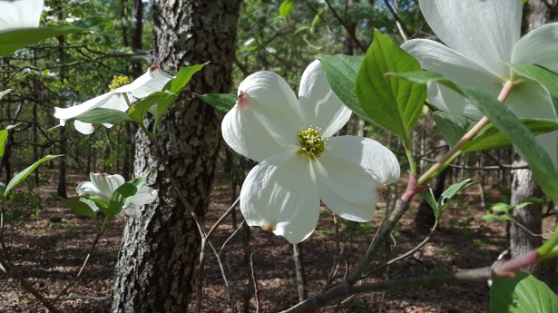
The third mini-winter is probably the most famous of the mini-winters, Dogwood Winter. Named for the Dogwood tree that blooms around the middle of April. It was after Dogwood Winter that farmers and gardeners could in normal years sow seeds in the ground for their gardens and fields; however, if you are sowing plant starts hold off until later as a few more freezes and frosts are possible.

The fourth mini-winter to show up is one that was lesser known to me until just a few years ago, Strawberry Winter. This cold snap coincides with the blooming of the strawberry plants, which generally will be ready for harvesting shortly after the last of the mini-winters. Strawberry Winter generally occurs mid to late April.

The fifth mini-winter is Locust Winter. By this point in the season we have experienced many warmer days and we begin asking ourselves if the cold weather will ever end; but if you watch the temperature trends we will have warmed considerably from the start of the mini-winters in March. The Locust trees are in full bloom during this winter and this one seems to be a rather windy one as well. It is after this winter that you can begin to sow your plant starts as the threat of a freeze or killer frost greatly reduces. This one hits in the later part of April.

The sixth mini-winter and possibly the last one you will really take notice of is Blackberry Winter. This is the last real stark reminder that the Spring is a season of change. The blackberry bushes are in full bloom. It is in this winter that people take to watching outdoor sports at their local schools and communities and are scrambling to locate their blankets or heavier jackets. Blackberry Winter does have the occasional killing frost for plants and even more rare, a freeze; but by this point the normal temperatures you are experiencing outside of the mini-winters is in the 70s if not pushing into the occasional low 80s. Blackberry Winter occurs in early May. I use this one to mark the time to open the swimming pool for the season, except in the case of 2020 as I already mentioned.
Now I will discuss the two lesser known and lesser felt winters for us in the southern part of the state but they definitely do occur; additionally, neither of these mini-winters are named for a plant in bloom.
Linsey-Woolsey Winter occurs in early to mid-May, it is also known as Britches Winter. This mini-winter is the last time of the season you will need your “winter” clothing. See the name linsey-woolsey comes from the material winter clothes were made from in eras of past. The material is a blend of linen and wool that provides insulation in the cold months of winter. It is after this mini-winter that the heat of summer starts to really crank up, but we have one more mini-winter to get through first and that is…

Whippoorwill Winter. This is the last of the mini-winters that occurs in late May to early June. The cold snap generally coincides with the return of the whippoorwill (bird) back to the area after its migration from wintering in Mexico. That said, on a late February or early March camping trip in the Hoosier National Forest I was kept awake most of the night by a whippoorwill that forgot that he was supposed to go south for the winter, he finally stopped “whippoorwilling” when the sun rose the following morning. This mini-winter may not be as easily noticed as the others but it is marked by a slight cool down from the normal day time temps. If you have a pool you may be putting a solar cover on it for this one, but you’re probably not going to change your daily attire. After this mini-winter the summer heat is on, and for us in the southern part of the state, we begin our roasting process for the summer.
I post every year on my Facebook page which winter we are experiencing in the southwestern tip of the state and every year friends threaten me to stop making winter last so long; generally most people find it informational and enjoy the content. Generally, my fellow Hoosiers in the northern portions of the state experience the mini-winters a week to two weeks after those of us in the south. I use it as a departure from winter and a countdown to summer, which is one step closer to my favorite season of autumn. I hope you have enjoyed this little tidbit about the many mini-winters of spring.
By the way, meteorologically speaking spring begins on March 1; however, astronomically speaking, which is the official start of spring, is marked by the spring equinox that occurs at 11:06p EDT (10:06p CDT) on March 19, 2024.
Sources:
The Six Little Winters of Tennessee: https://visitclevelandtn.com/the-six-little-winters-of-tennessee/
The Five Little Winter of Tennessee: https://halfhillfarm.com/2013/05/13/the-five-little-winters-of-tennessee/
What Is A Linsey-Woolsey Britches Winter: https://wbkr.com/what-is-a-linsey-woolsey-britches-winter/
Little Winters: https://www.wherethedogwoodblooms.com/little-winters/
