In this issue of

Volume 10, No. 5
- Cedar Grove’s Odd Building: How Quickly History Can Disappear
- Pigtails
- Roanoke, Indiana: A Wabash & Erie Canal Town
- Frog Follies
- The Chesapeake and Ohio Canal from Washington D.C.
- Hutchen’s Lock? Don’t Believe All That Ypu Read
- Outreach Events & Programs
- Delphi News
- From the Whitewater Valley
- Canal Society of Indiana

Cedar Grove’s Odd Building:
How Quickly History Can Disappear
Carolyn I. Schmidt

Whenever I, Carolyn Schmidt, start to read a historical novel where the author has listed his cast of characters telling who they are or were and how they related to one another or to the topic of the book, I am always very appreciative. My cast of characters/sources when found in this story will be represented by the bold name before their description and will be in parenthesis. Example.(Baudendistel)
- Baudendistel — R. Paul Baudendistel, currently of Metamora, once lived alongside the Whitewater Canal in Brookville. He spent years researching its magnificent structures and the canal boats, captains, owners, etc.. Paul, an early member of the Canal Society of Indiana, working with Bob & Carolyn Schmidt as editors, published Notebook No. 1: The Whitewater Canal Boat Log in August 1995. In it he names the boats, quotes his sources, and has drawn pictures of them.
- Bischoff — Paul N. Bischoff, a local historian of Rochester/Cedar Grove, has written a book about the changes that Rochester experienced over the years entitled Rochester to Cedar Grove: The Transformation of Franklin County’s Highland Township Canal Town. He supplied Julie Schlesselman with copious information for her article “Rochester to Cedar Grove.”
- Bob — Robert F. Schmidt, CSI treasurer and past president from Fort Wayne, contacted Jo Sorn, the resident of the odd Cedar Grove building, took pictures, and helped with research about it.
- Burden — Donald R. Burden wrote The Whitewater Canal Historic Corridor Guide as a requirement of Ball State University‘s Graduate School for his M. S. degree in May 2006. It details the history of the Whitewater Canal, its structures, tells what still exists, and includes Rochester/Cedar Grove.
- Carolyn — Carolyn I. Schmidt, CSI’s “The Tumble” coordinator from Fort Wayne, interviewed Jo Sorn, who lives in the odd Cedar Grove building, contacted book authors and newspaper columnists, and wrote this article.
- Chronicles — An article in the Indianapolis News, Indianapolis, Marion County, 6 February 1902 that was found in Hoosier State Chronicles. A staff correspondent, W. H. Blodgett, interviewed Captain Josiah McCafferty and then wrote the article, “Canal Boat Competition, Intense Rivalry Existed In The Old Pioneer Days. Fights Not Uncommon,” which includes McCafferty’s reminiscences.
- McCafferty — Captain Josiah McCafferty reminisced to news paper reporters or to authors about his days on the Whitewater Canal. His recollections seem to be the oldest that can be found in any source and are basically the source of all later articles.
- Ron — Ronald V. Morris Ph.D., is Chair and Professor of Ball State University’s Department of History and the President of the Canal Society of Indiana. He found Cedar Grove’s odd little building on a canal hike. He has restored U. S. Representative James Rariden’s home and Governor Oliver P. Morton’s home in Centerville, Indiana and Dr. Jefferson Helm’s home in Rushville, Indiana. Ron got permission to place over 16 CSI signs along the route of the Whitewater Canal in Indiana’s Dearborn, Fayette and Franklin counties in Indiana and worked with local entities to donate the posts and crews to erect them.
- Schlesselman — Julie Schlesselman of Brookville, is the Local History & Genealogy Department Manager of the Franklin County Public Library District and wrote the article “Rochester to Cedar Grove” that was published on October 9, 2024 in the “Forgotten Franklin County” column she writes for the Brookville American. She furnished CSI with her plat maps of Rochester/Cedar Grove, pictures she had taken of the odd building there, and many other old photos used in this article.
- Sorn — Jo Sorn resides in Cedar Grove’s odd building. She provided information about the building, said it was added onto, described the small slanted attic above the original structure, gave names and E-mail addresses of contacts, showed us the newspaper article by Julie Schlesselman and an advertisement for the T. Morse Canal Boat Company.
On April 6, 2026 Bob & Carolyn Schmidt met Dr. Ron Morris at the restored home of Governor Oliver P. Morton in Centerville, Indiana to go to the Dearborn County Dedication of CSI signs at 5:30 p.m. that evening. They left the Morton house right away for Ron wanted to show them an odd building he had found on the Whitewater Canal in Cedar Grove. He wondered how it had been used during the canal era, and what they knew about it. They had not seen the building and were eager to see it.
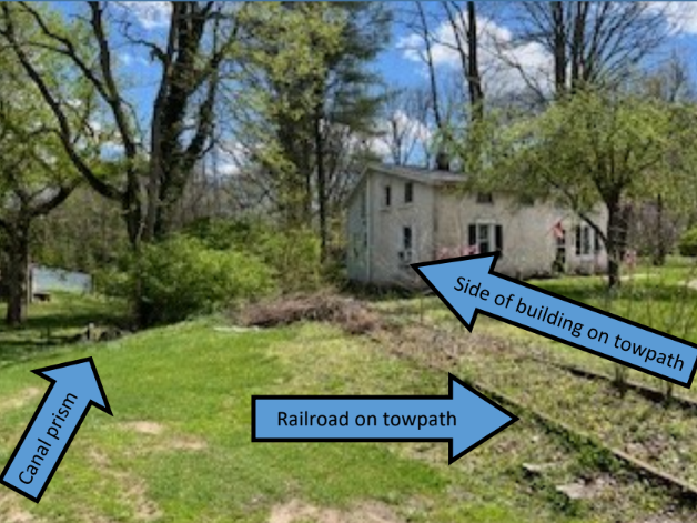
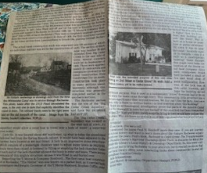
When they arrived at 305 2nd Street in Cedar Grove, they stopped to take pictures and Ron was asked if he had contacted anyone who lived in the building. He hadn’t, so Bob went to the door, knocked, and was greeted by Jo Sorn, the current resident. When she was told they were from the Canal Society of Indiana and wanted to learn more about the building, she immediately invited them inside.
Sorn said she is always interested in learning more about it and showed them an article by Schlesselman and an advertisement for the T. Morse & Co. that had been published.
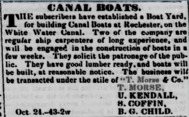
The Indianapolis News later carried this advertisement
from October 24, 1843 in a story by W. H. Blodgett, February 26, 1902
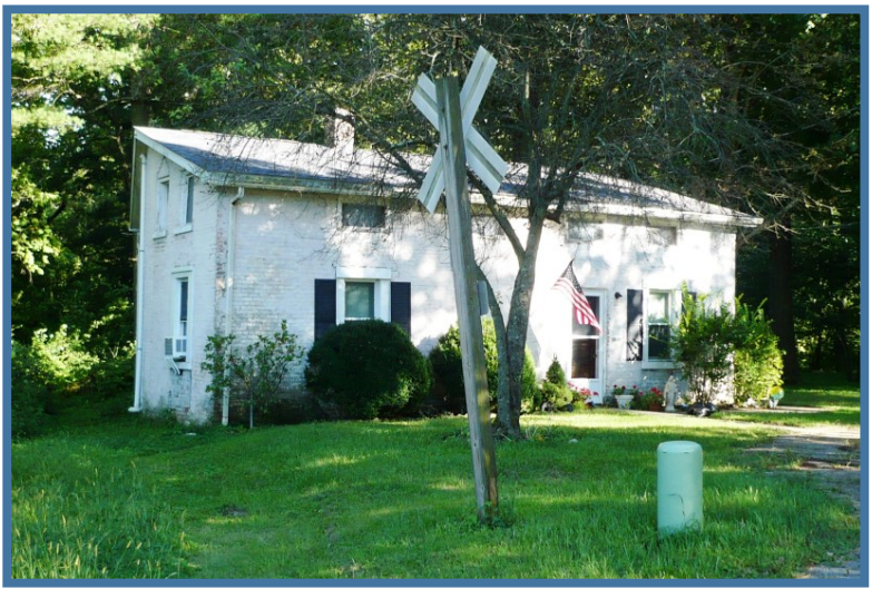
When asked what she knew about the building, Sorn said when it was built it had the slanted side on its left because it was on the towpath of the Whitewater Canal. It had a two story structure added to it later on that they could see by the roof line. The original building still has a staircase that leads up into a slanted attic above it but does not connect to the addition. The addition has its own stairway to the second floor. She thought it had been part of a canal building and repair drydock operation. She suggested they contact Schlesselman and Bischoff since both of them had worked with her trying to discover more about the building.(Bischoff, Bob, Carolyn, Ron, Schlesselman, Sorn)
After Ron, Bob & Carolyn left they discussed when they thought the building had been built and its use. The advertisement for the boat yard was published in October 26 and November 2, 1838 in the American newspaper from Brookville. They knew the Whitewater Canal had been built from Brookville, through Rochester/Cedar Grove, to Lawrenceburg between 1836-1839 and would fit into the time frame. They ruled out that it may have been a weighlock, because weighlocks were expensive to build and no Whitewater Canal engineers’ reports can be found of one being built there. Considering it might have been a lock tender’s building, there didn’t seem to be any remnants of a lock nearby. They also noted that the canal prism had been filled in for many yards in the area to the northwest of Sorn’s building and there was nothing built upon it. It seemed wide enough to have been a boat yard, which would have needed an office space and a place to store tools or work on small items. If it was the place of a boat yard, was it the T. Morse & Company yard? Since they had to get to Lawrenceburg in time for the signage dedication, they had no more time that day. They planned to do further research.(Bob, Carolyn, Ron)
After returning to Fort Wayne, I, Carolyn Schmidt, began reading Schlesselman’s article, Baudendistel’s book, an article I had previously written in a CSI tour guide, old histories in the CSI archives and Burden’s Corridor Guide. On-line I found an article in Chronicles. I talked to Schlesselman, who then sent her plat maps, pictures, and her original article to me. (Baudendistel, Burden, Carolyn, Chronicles, Schlesselman)
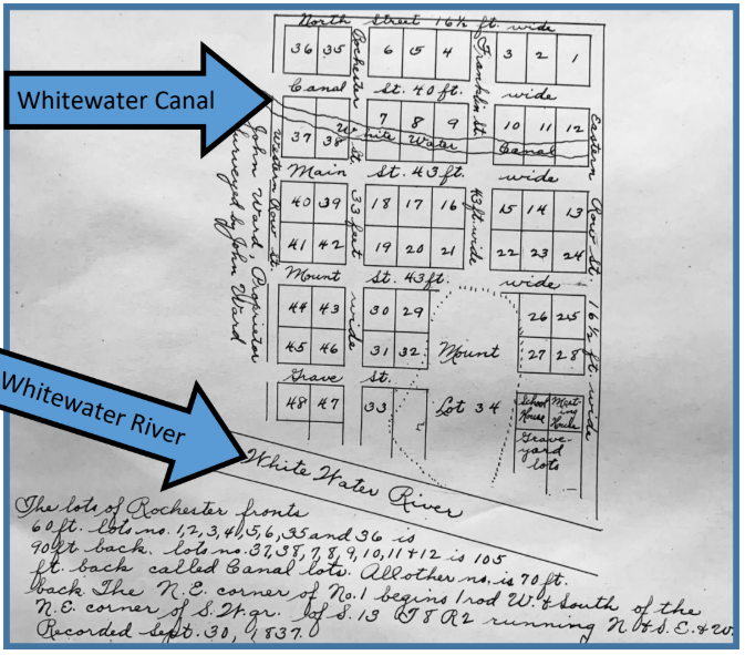
The lots of Rochester fronts 60 ft. lots no. 1,2,3,4,5,6,35 and 36 is 90ft. back, lots no. 37, 38, 7,8,9,10,11, +12 is 105 feet back called Canal lots. All other ns. is 70 ft. N. E. corner of S. W. gr. of S. 13 T8 R 2 running N. +S. E. + W. Recorded Sept. 30, 1837
“Rochester, the original name of the town of Cedar Grove, is in Highland Township. Settlers came in the early 1800s and John Conner (1775-1826), who went on to found Connersville in Fayette County and serve as a State-Senator and Representative, was one of the earliest traders there.
“The town of Rochester was there before the Whitewater Canal came through. John Ward, considered the town’s founder, was born in Virginia about 1790 and was in Franklin County by 1816. He was an active participant in many private and public ventures in Franklin County and platted the town of Rochester in 1837 from lands he personally owned….Census records show he was alive in 1850, but it appears he died by 1860. No record of his death or a burial location has been found.
“In 1803, there were approximately ten families living along Big Cedar Creek near what would become Rochester and eventually Cedar Grove. According to research done by Paul N. Bischoff, an odd tidbit of trivia regarding the Rochester area claims John Conner had a mill in town and Anthony Halberstadt lived near the mill. Halberstadt was one of the thousands of Hessian soldiers taken prisoner by General George Washington near Trenton during the American Revolution. The United States Congress authorized the granting of up to 50 acres of land to individual Hessian soldiers who switched sides. Halberstadt switched sides. This Hessian, turned American Revolution soldier, lived in Pennsylvania before moving here to Highland Township. He died in Franklin County in 1835 and is assumed to be buried in the Little Cedar Grove Baptist Church cemetery.
“Why is Rochester important? Because it was a canal town — a canal town that not only shipped goods but was a destination for receiving goods, as well as a stopping point for weary travelers along the line. Most importantly, canal boats were manufactured there. In Franklin County, Metamora is the better known of the canal towns, because it still has a small segment of the canal extant and was highly marketed in the mid-20th century as a tourist attraction. Laurel, Brookville, and New Trenton were also canal towns, but the canal ran on the outskirts of those areas, — not through a central part of town as it did in Metamora and Rochester.” (Schlesselman)

Image from the Shirley Seufert collection, FCPLD
“To give a basic timeline regarding Rochester and the canal…In 1834, the Indiana Legislature directed canal commissioners to begin surveying what is known as the Whitewater Canal. The survey work was completed in 1835. In January of 1836, construction of the Whitewater Canal was approved by the Indiana Legislature. In 1837, John Ward laid off part of his land in Franklin County as a town and named it Rochester. In October 1838, the “T. Morse & Company Boatyard” was in full-swing in Rochester. (It was a completely separate operation from the canal construction project.) In June of 1839, the first canal boat traveled on the lower section from Lawrenceburg to Brookville passing through Rochester.” (Schlesselman)
Captain Josiah McCafferty lived in a handsome country home between Rochester and Brookville. He was said to have been the last of the captains who sailed the Whitewater Canal by his interviewer W. H. Blodgett, who described him, at age 80, as hale and rugged, considerably deaf, but beyond that as lively a man of sixty. (Chronicles)
“Well, I know a few things about that old canal,” said Captain McCafferty, “for, man and boy, I have been near it all my life. I used to hide behind the trees and throw stones at the Irish laborers, who were brought here to dig it. The digging began, I think, in 1836, and I think it was along some time in 1839 that the water was let into it from Lawrenceburg to Brookville [Brookville to Lawrenceburg], and if I remember right, it was opened to Cincinnati along about 1843. The canal broke in 1847 and again in 1852, and caused considerable damage, but it was built up again and business increased for a while and then began to let down.” (Chronicles, McCafferty)
“The actual canal construction work was separated into 138 sections of which an individual contract was let for the construction of each. The section at Rochester was number 50 and extended from Big Cedar Creek to the east side of town. Several contracts were let in September of 1836. There were approximately 25 contractors and companies involved in the canal construction from Cambridge City on south. Construction took place in many sections simultaneously, although construction was generally completed earlier in the southern sections.
“The Rochester section was the site of the ‘Big Cedar Creek Aqueduct’ and Lock No. 14, which had an 8’ lift…The ‘Big Cedar Creek’ Aqueduct was located at the west end of town. An aqueduct would allow a canal boat to travel over a body of water — water over water.
“Lock No. 14 was located about 400’ northwest, up what is today the abandoned railroad bed from the Spring Branch culvert. It would have been adjacent to the current barn located at 406 2nd St. A lock is an impressive stone structure which consists of a watertight chamber used to adjust water levels as required. Boats were then raised or lowered by filling or emptying the lock chamber. Gates at each end of the lock chamber allowed the boats to enter and leave. There are no remains of this mighty structure, unless it was filled in and buried over.” (Schlesselman)
“The canal boats were brought over from and taken off this canal and put onto the Miami-Erie Canal in Ohio. Evidently then, our boats were very similar in design and classification as those boats navigating the Ohio canals….Canal boats changed hands periodically, and upon being transferred, were often renamed…Canal boats were built in this valley, in more than one location. Boat yards were also used for the refitting, maintenance, and storage of vessels.” (Baudendistel)
McCafferty said, “The first boat was the Ben Franklin. She had been running on the Miami canal for a number of years, and it was decided to bring her over here. She was dropped down the Miami canal to the Ohio river and floated to Lawrenceburg and put into the Whitewater canal. I bought her and changed the name to the Henry Clay, and there weren’t any boats on the canal that could make any better time. I built a number of boats to sell, and always got a good price for them. The first boat built at Cedar Grove was called the Native, and when she started on her first trip there was a good deal of excitement all along the canal. The Native was a passenger and freight boat and was fitted up in a manner that was gorgeous for those days. There were two cabins and large state rooms ranged on the side the same as is now seen on passenger steamers. Stephen Coffin was the builder and captain, and when he started out on a trip he always made a good deal of fuss about it.” [S. Coffin is listed in the advertisement for T. Morse and Co. Boat Yard.]
“Finally I built a boat called the Belle of Indiana, and there was nothing on the canal that touched her anywhere. The swan line of packets was put on about that time. They did not carry anything but light freight and passengers and it was expected then they would make a fortune for their owners. But they did not pay, and after a season or two they were withdrawn. I carried passengers on the Belle of Indiana and some of the most famous men of the day used to ride with me, but I did not pay a great deal of attention to them for I generally was too busy.
“There was an intense rivalry between the boats, and the way they used to race was a caution, and when one boat tried to pass another it was about sure to end in a fight. The crew of the boat was the captain, two steersmen, cook and driver, and sometimes they all got into it. Down near Cleves, O., one time, two boat crews got into a fight and one of the men was killed — that was the only killing I ever knew of, but I saw a whole lot of them beat up.
When asked if he ever go into a scrap, McCafferty replied, “Oh, I guess I had my share,…but none of them was ever serious. You see, I had one of the fastest boats on the canal, and when I came round the bend, the other fellow just took it for granted that I would go by, so he hugged the shore and let me pass.
“…I had right smart of excitement, but the greatest time was when they opened the canal to Cambridge City. We knew for a long time that the canal was to be opened up in that place but we did not know just when it would be, so we all laid away as much as possible and waited for the word. Several times it was reported the water was coming down, and we would edge up close and get ready for the rush. It was just like the rushes they make down in the Indian Territory, except we have canal boats instead of horses. At last the word came that the water was in the canal at Cambridge City, and we started.
“There were twenty boats, and every one tried to get by the other, and when we had to make the locks, I tell you, there was some tall swearing and not a little fighting, but no one was hurt. My boat and all the other packets were crowded with passengers. I had the Belle of Indiana then, and there was such a crowd on the deck that I had to separate them so the steersman could see the bow of the boat. When we got in sight of Milton it seemed as if the whole United States was there. There were two or three cannons fired and yelling like Indians. John Lemon was captain of the Belle of the West, and I was pushing him mighty hard, for he was in the lead. But the water was not deep enough for a good race and he beat me into Cambridge City, but I was right behind him.
“The crowd at Milton was not a patching to the crowd at Cambridge City. There were cannon, more bands, the State officers were there, and everyone had a great jubilee. They kept it up all night and most the next day and everyone had any kind of fun he wanted, and did not have to pay for it. I tell you, there is a big difference now and then. Why, we went through stretches of woods four and five miles long then to get to Cambridge, and it would be hard to find a stretch now half a mile long. Those were the great days, though, and everyone made money, but mighty few kept it. It was come easy and go easy.
“…I was around the canal about all my life, but I ran a boat about seven years, and good years they were too. But I saw that the business on the canal was falling off, and so I sold all my boats, closed out my business, bought a farm, and have been farmer ever since. I’m getting to be a pretty old man, and want a rest. I guess that I am about the only one of the boys who used to run on the canal that is left, and it won’t be very long until I tie up forever.” (Chronicles, McCafferty)
“Regarding the T. Morse & Company Boatyard…The first canal boat constructed at Rochester, the Native, was also known as a packet boat, as it carried both passengers and freight. Co-owner of the T. Morse Boatyard, Stephen Coffin, oversaw construction of the Native and also served as it first captain. This boat made regular trips between Lawrenceburg and Brookville, leaving Brookville on Monday, Wednesday, and Friday at 6:30 AM and arriving in Lawrenceburg in the evening. On Tuesday, Thursday and Saturday, the Native left Lawrenceburg at 6:30 AM, arriving in Brookville the same evening. It made its inaugural trip to Brookville on July 3, 1839. There were many canal boats constructed at Rochester, and at least six were located there.” (Schlesselman)
A list of canal boats that plied the Whitewater Canal are listed below. (Baudendistel)

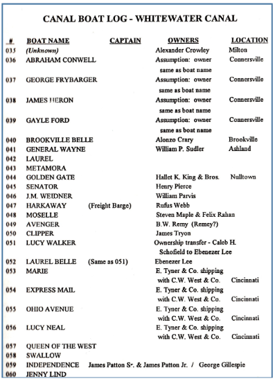
“Today there are no remnants of the T. Morse & Co. boatyard left to see. There are a few theories on its location, and Paul N. Bischoff believes it was located near the north side of the aqueduct near Big Cedar Creek. He claims, ‘I have seen a very old photo of a saw mill along the creek just a little more north. It makes sense that the boatyard would have been near the saw mill and the creek.’” (Schlesselman, Bishoff)
“In 1842, there was an ad in the local newspaper for a new “line” for travel between Cincinnati to Brookville passing thru Rochester. In an effort to improve travel time, a canal boat would make the trip between Brookville and Lawrenceburg, where they would then board a steam boat on the Ohio River for the Cincinnati portion of the trip.
“In 1847, there was a significant flood which was responsible for considerable damage to the canal. This was a financial setback and an ongoing problem. Continued maintenance requirements were expensive and with the advent of the railroad, the canal was out of service by the end of the Civil War.
“…Over the years, on maps and in a variety of written documents, the names of Rochester and Cedar Grove were used interchangeably. It wasn’t until January 16, 1851, when the General Assembly of Indiana passed an Act to legally change Franklin County’s town of Rochester to Cedar Grove, ‘the name of the post-office in said place.’
“On January 30, 1833, the first postmaster, Hezekiah Coffin, was appointed at Rochester even though the town had not yet been formally platted. It was because of the United States’ Post Office designations that Rochester eventually had to change its name. Some of the key dates in this chain of events include…In 1835 the town of Rochester in Fulton County, Indiana was officially platted — this was two years prior to the one in Franklin County being officially recorded. In 1836, a postmaster was appointed for the town of Rochester in Fulton County. In 1837, the town of Rochester in Franklin County, Indiana was laid out and officially platted and recorded in county records. Since there was already a town and a post office with a functioning name of Rochester established in Fulton County, the town of Rochester in Franklin County had to name their post office something different. There could only be one post office in the state with a particular name. The name Cedar Grove was assigned to Franklin County’s Rochester Post Office. (Schlesselman)
This picture is from the February 26, 1902 Indianapolis News.
At the conclusion of her article Schlesselman asked the following questions:
- “Exactly where was the canal boat manufacturing yard?… Multiple people have done research regarding the Whitewater Canal through Rochester but can’t find anything in detail about the canal boat construction company owned by T. Morse.
- “Why have other stories and lore been passed down about the town and its people but not something as significant as the location of where canal boats were made?
- “…how can that be when many families in Cedar Gove have resided there for multiple generations?
- “Have oral stories been lost and old papers and records just been tossed?
- “What was the intended purpose of the odd little building on 2nd Street in Cedar Grove?… Lock No. 14 was supposed to have been near 406 2nd St. If you look to the west of that address to 305 2nd St., there’s a small house. It you’ve never seen the building, it is an odd little thing. It’s constructed of bricks and resonates of 1820-40s architecture, and is atypical for our area; the back of the slim structure is higher than the front.
- “Does this building pre-date the town?
- “Was it built as a house or some type of public structure? “…since it was so near the canal —basically right on its towpath — was it built as a canal-specific building?…Some thought this might have been the location of the Morse canal boat company since such enterprises would have included a small office and wood shop of some configuration. However, if the lock was at this same location, perhaps the building served a different purpose.
- “Was it used as a lockkeepers’ house? …Someone had to be on call when the boats came through town.
- “Why are there no oral stories or writings about what happened to Lock No. 14?
- “Would an archaeological investigation prove that parts of the massive Canal Lock No. 14 are still in town but just buried?…If the canal lock had been dismantled and used for other purposes surely some building in town would have utilized the cut stones. (Schlesselman)
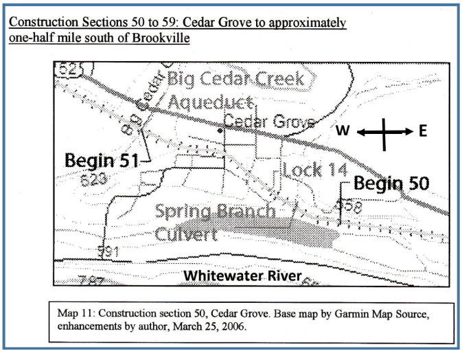
In 2006 in his The Whitewater Canal Historic Corridor Guide Don Burden had used McAfferty’s article and had come to the same conclusions as Schlesselman. However, he did find that Sections 51 and 50 were the sections of the Whitewater Canal that were constructed through Cedar Gove and made the following map.
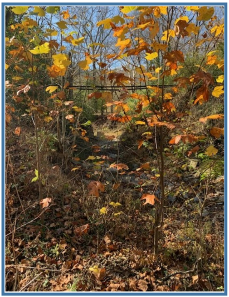
Joel Palmer contracted to construct section 50; earned $16,875.22 for building one-half mile of canal prism, a culvert, a lock, and a road bridge; and completed his section in about eighteen-nineteen months time basically in 1837. The stone arch culvert over Spring Branch still existed at the time of Burden’s study and freight trains passed over it several times a week. The white oak timber foundation was still intact.
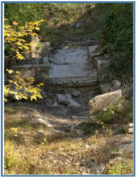
Timbers covered with concrete
Photos by Paul Bischoff
Paul Bishoff went to the site of the culvert when doing research for a book he and Schlesselman were writing on the history of Cedar Grove and found the culvert had been destroyed, concrete covered the timbers in the creek and the railroad tracks hung in mid-air. He thought the culvert probably had been in good condition up to 2011 from a photo he had found online. (Bischoff)
Cedar Grove’s Lock 14 was approximately 400 feet northwest of Spring Branch and had an 8 foot lift. Backhouse’s or M’Clures quarries probably provided the stone for the lock. If anything remains, it has been covered over by several feet of earth. Burden suggests an archaeological dig.
Palmer’s bridge over the canal was probably destroyed by the Whitewater Valley Railroad crews since the trains could not pass beneath the low structure. Even canal boat passengers had to duck their heads when passing beneath the bridge.
Photos by Paul Bischoff
The T. Morse & Company’s boat yard was at Rochester, which was located toward the east end of what later became Cedar Grove, and probably was located on the berm bank on the north side of the canal away from the busy towpath. “The north side of the railroad tracks near the east bank of Big Cedar Creek provides one possible location for the yard. The flat land around the site of lock 14, near the Cedar Grove feed Mill, presents another possibility.” (Burden)
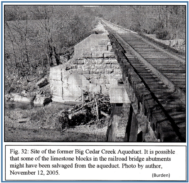
Section 51 extended from the west end of Cedar Grove to Big Cedar Creek for about one half mile; consisted of one aqueduct with two thirty-four foot spans probably built with stone from Backhouse’s or M’Clure’s quarries; and Joel Wilcox was its contractor. Wilcox probably started construction in January or February of 1837 having several contracts over a period of time. He probably completed his section after early June 1839 since he was not paid for it until January 1840. In early June 1839 the State of Indiana was unable to pay contractors because they did not have funds.
The Big Cedar Aqueduct was an open trunk aqueduct that had two thirty-four foot, simple-king-post, spans, each supported by a limestone abutment and a central limestone pier. The towpath was built on the side of it. Locals seem to think the aqueduct was actually built by Joel Palmer even though Wilcox held the contract. It was not unusual for a contractor to hire a subcontractor for mechanical work. It is thought that the cut limestone blocks from the aqueduct were later used for the abutments of the railroad. (Burden)
Bishoff went to the Franklin County Recorder’s Office to look for tax records for other historical buildings. He found that these records were not kept prior to 1990.
Bischoff speculates that the oddly shaped house near Cedar Grove within five feet of the towpath was a staging area to load and unload canal boats years ago. He believes Lock # 14 was West of 2nd street in town. (Bischoff)
There are still many questions to answer about Cedar Grove’s odd little building, the location of Lock #14 and where T. Morse’s boat company was located. This study just shows how quickly canal history can be lost. From the building of the Whitewater Canal through Cedar Grove 1837-39 to 2026 is only about 188 years.

Pigtails
By Susan Yoder

This is the second of a series of articles originally published in the Canal Society of Indiana
Newsletter between March 2001-April 2002.
Give Me Your Tired, Your Boar,
In his advice to emigrants, Solon Robinson recommended in his 1840-41 letters to the Albany (New York) Cultivator, that settlers forego the transport of useless pieces of furniture into the pioneer wilderness, but rather bring “the worth of it in ‘Berkshire pigs,’ ‘Durham bulls,’ and ‘Leicester sheep,’ and other improved machinery, that will add much more to your wealth and comfort, than mahogany side-boards, tables and chairs, and gilt looking glasses…Let no one come here with the expectation of finding wages high, provision low, land so cheap that he can get an 80 acre farm for $100, and consequently that he will be able to acquire an independence with little or no exertion on his own part. True, land is cheap – it is hardly possible to imagine a soil more rich, but land bought of the United States at $1.25 an acre, is not a cultivated farm…No emigrant need fear any difficulty in bringing along cattle and hogs. Several of the masters of steamboats on the Lakes, seem to take great interest in the shipment of choice stock to the West. I have had three lots of pigs shipped from Buffalo to Chicago during the last summer, in the sole care of the master of the boats, and from the appearance of the pigs on arrival they must have been treated like cabin passengers. In fact, none but a brute could maltreat a Berkshire pig.”
From Readings in Indiana History, compiled by Gayle Thornbrough and Dorothy Riker, Indiana Historical Bureau, Indianapolis, IN. 1956, pg 206-210. Excerpted from original letters addressed to the Albany (New York) Cultivator, by Solon Robinson in 1840-41, quoted from Solon Robison, Pioneer Agriculturist, edited by Herbert A. Keller, Indiana Historical Collections.
Finally, the 1870s brought the Victoria (bet she was thrilled with her namesake) and my favorite black and white belted Hampshire.
The Indiana Historian. August 1994, vol. 7027. The Indiana Historical Bureau, Indianapolis, IN. pg 3.
(Now we know what Victoria’s Secret was!)
This Little Piggy Went to Market…
All of the hogs bred to improve the carcass merchantability from then to now, haven’t met with unqualified success. The Cottswald and Pietraien hogs are two that come to mind in that category. The latter was a meaty animal, but neither could stand stress. If you’ve watched “Charlotte’s Web,” Wilbur exhibits the demeanor representative of the aforementioned breeds with a healthy dose of artistic license. In the movie when the conversation turns to a market-weight, Wilbur the hog, heading for the “chop shop,” faints. The sentimental embellishment of fact in this children’s classic is evident when the hog is continually revived. Once down, too many Cottswalds and Pietraiens didn’t get up again.
In 1810 and 1811, the manifests of flatboats passing Louisville included the following: 1,513 hogs, 22,602 barrels of no-longer-alive pork and 1,008,026 pounds of bacon. In 1826, Indiana flatboats were hauling pork in various forms to New Orleans.
Preceding the U. S. Department of Agriculture by fifty years, an 1820 Louisiana law appointed one inspector and three re-packers for beef and pork and the heedless shipper could pay up to $1.12 per barrel for product inspection and re-packing. Pork was classified as mess, prime, and cargo. Barrels were to be constructed of seasoned white oak or white ash, 18 inches between chimes: and 28 inches long. Two pecks of coarse salt, 6 percent saltpeter, besides pickle” (brine) were the minimum required per barrel.
Readings in Indiana History, pg 300.
*Chime: the extended rim at each end of a cask or barrel.
Webster’s New World Dictionary, David B. Guralnik, The World Publishing Co., 1978.
There’ll Be A Hog Time In The Old Town Tonight!
By 1834, 30,000 hogs were driven through Brookville, IN to Cincinnati, OH in one season. (We think we have potholes!) In the 1860s, Indiana ranked first in hog production. By the 1870s, Indianapolis ranked fourth in the nation in pork packing.
The Indiana Historian. pg 3.
The canal was a boon to farmers shipping their surplus goods to market. By 1843 Samuel Hanna was in the process of financing a large-scale slaughterhouse at Fort Wayne. The December 28 issue of the Fort Wayne Times reported that 1848 saw upwards of eight thousand hogs packed there per season.
Poinsatte, Charles R. Fort Wayne During the Canal Era 1828-1855. Indiana Historical Bureau, Indianapolis, IN 1969, pg. 239.
“The Wabash & Erie canal affords the inhabitants every facility for the transportation of their heavy merchandise, while the Wabash river, navigable for steamboats six months in the year, carries a great amount of pork, grain, etc. to the southern markets. This city is known as one of the leading pork-packing points in the west….It is stated that the number of hogs packed in Terre Haute has reached 110,000.”
Gookins, Judge S. B. History of Vigo County Indiana. Chicago, IL/HH Hill and N Iddings Publishers, 1880, pg. 109.
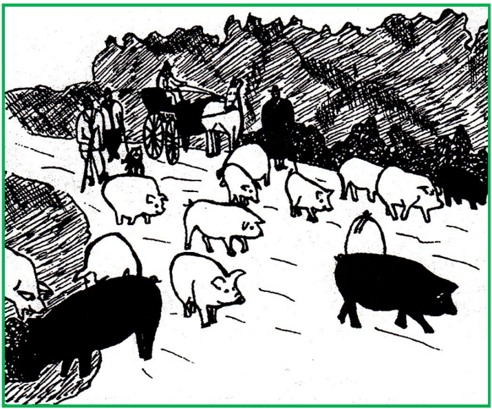
“Add to this that corn would grow on our prairie for the planting, and hogs would fatten in the fields of corn with little or no care, so that very soon our river front was lined with slaughter and packing houses, and our streets in the fall and winter with droves of hogs…This last scene of droves of hogs spoken of was common, and yet it was not a common scene. The unthinking surging mass were driven, they knew not where, but the drovers knew, and took every precaution to carry out their purpose. The headsman, either on horseback, or on foot, led the way scattering corn, thus enticing the hogs to follow, at the same time uttering a county call that the pigs understood, but a pencil cannot express in letters. Men were stationed on either side at the crossing of the streets, and alleyways, to prevent wayward from escaping. Then came the regular drovers with sticks urging the mass forward. Still behind these, were two or more men, each having in charge a very fat porker, who notwithstanding the most patient urging, could not keep up with his fellows, and would sooner or later find a place in one of the wagons in the rear provided for such tired stragglers. This prosperity of Terre Haute as a village, and for years after it grew to be a city, was phenomenal, and was largely due to the pork trade. It is said for a time we were in danger of losing our beautiful and appropriate name, Prairie City, and ever afterwards to be ridiculed under the name of Hogopolis. But the decline of the pork traffic, saved us from this ignominy.” How you gonna keep ‘em down of the farm after they’ve seen prairie?
Condit, Blackford D. D. History of Terre Haute 1816-1846, New York, N.Y. : A. S. Barnes & Co., 1900. pgs. 147-148.
Drawing from an old photo by Carolyn Schmidt
“The early policy of the state had been to make this river trade (Wabash and White rivers to New Orleans) a part of a great trade route from New York to New Orleans, but the extension of the (W & E) canal to Evansville eliminated the Wabash river as a part of the route entirely…In 1836 the cheapest freight route from New York to southern Indiana was by New Orleans and the rivers…By 1847 the total receipts at Albany (New York) had surpassed those received at New Orleans, and gradually this difference increased. This means that the interior states were seeking their outlet to New York instead of New Orleans and is significant as one step in turning the business interests of Illinois, Indiana, and Ohio toward the North and East. That is, with the turning of commerce from the Wabash river, the last cord binding Indiana economically to the southwest was severed…”
Readings in Indiana History. p. 334.
Swine Lake – A Cellar’s Market
“It was a great day for Logansport (Indiana) when water was turned in the (W & E) canal. The entire population gathered on the banks to greet the oncoming tide, which was to bring prosperity to Logansport’s commerce… It was a muddy, trickling stream that found its way first through the forest, which crowned the hills above Fifth street. At length it was whispered around at dusk that the canal was filled. But there was not general rejoicing the next day, for the rock through which the canal was blasted was made up of layers with seams between and the entire population was engaged in bailing out the cellars below Fifth street. The supply of canal water was inexhaustible, however, and the effort was a dismal failure.”
Wright, W. Swift. Pastime Sketches. Logansport, IN: Cass County Historical Society, 1907. pg. 39.
For time-sensitive cargo, the canal was the most expedient, but at a price. “We traveled day and night, as is customary on all canals, and completed the trip in 6 days,” complains one less-than-satisfied passenger. “The trip is very expensive. If I were doing it again, therefore, I should certainly go to New Orleans, and come up the Mississippi and the Ohio to Cincinnati. It does not cost half as much, and I advise anyone who wants to come here to take that route; it is best in every respect.”
Readings in Indiana History. pg. 206.
The trials of communing with the civilized world for only a portion of the year are related by Williamson Wright of Logansport. “In 1843, at the age of 16, I commenced clerking for the firm of Henry Martin & Co.. It was then I met Mr. John C. Merriam, with whom I was afterward associated in partnership for thirty-five years. He was eight years older than I, and an experienced dry goods merchant. He was from Brandon, Vermont, on his way west looking for a location, when he fell in company with Mr. Henry Martin….It was during my stay there that a tornado swept over Logansport, unroofing part of the new court house…carried away the hat of the County Treasurer Howes, containing a lot of “verbal orders.” In October following that summer I accepted the position of clerk and bookkeeper for Pollard and Wilson, which I held for seven years from 1845 to 1852. …They had never tried the packing of pork. The season for pork packing in those days was from about the first of December to the middle of January. There was no good market for it at any other time. Now, there is a good market for it all the time. A. M. Seering from New York used to come out every season and join Israel Johnson in packing at his warehouse on the canal, and they found the business profitable. In the year 1847, Pollard & Wilson and Taber & Chase concluded to unite and try their luck at the business. Pork was quite low that season, the price running from 1.87 to 2.25 per hundred. The average price of pork purchased was 2.10. When navigation opened the next spring the price had declined and continued to decline until mid-summer. They finally shipped their mess pork and lard and sold it at a small loss and to reduce the loss as much as possible had the hams and shoulders smoked and retailed them out during the summer and fall. By this tedious and troublesome method they reduced their loss to a little less than one thousand dollars. While our merchants duly appreciated the advantages of water transportation, enabling them to obtain large reductions in freight, they still labored under the great disadvantage of having navigation closed for about half the year. In the fall it was necessary to make large purchases to last until the opening of navigation in the spring. …It was customary in those days to purchase goods on six months’ time. That was the understanding with manufacturers, jobbers and retailers. The customer was allowed the prevailing rate of interest on any payments he might make before the bill became due. …Merchants could ….while navigation was open from six to seven months of the year, get merchandise from Cincinnati in three or four days’ time, and from New York it took about three weeks, as it came by steamer from New York to Albany, by canal from Albany to Buffalo, by steamer from Buffalo to Toledo, and by canal again from Toledo to Logansport.
Pastime Sketches. pg. 166-167.
Roanoke, Indiana:
A Wabash & Erie Canal Town
Carolyn I. Schmidt


Roanoke and the surrounding area was once the hunting and fishing grounds of the Miami Indians. However, this soon changed when the Wabash & Erie Canal was opened from Fort Wayne to Huntington.
Before reaching Roanoke in Huntington County, canal boats passed over three culverts that had been built about 1833. In 1847, 14 years later, Jesse Lynch Williams, Chief Engineer, inventoried the canal’s structure’s condition to report to Indiana General Assembly before they turned it over to the Wabash & Erie Canal Trust.

Red line traces the Wabash & Erie Canal from Huntington Co. to Allen Co.
Blue arrow points to Roanoke, Indiana
Culvert. No.33 that was west of Fort Wayne built of wood, 10 feet by 18 inches and submerged.
Culvert No. 34 was a large wooden culvert over Calf Creek, of 2 spans, each ten feet wide and five feet high of rectangular shape. The covering timber of the culvert was exposed to the air after its erection in 1833 and was partially decayed. Williams found it had strength enough to sustain the weight, if the decay was now checked. He recommended that a dam be erected just below the culvert and made water-tight to submerge the whole structure. This he thought would cost $100, but would be far more economical than a renewal of the whole culvert, which otherwise would be necessary within 2 or 3 years.
Culvert No 35, of timber, 10 feet by 18 inches, submerged.
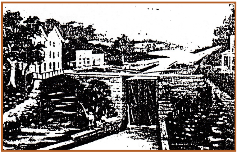

Still standing at time of the interurban – Note its tracks in the lower right of the picture
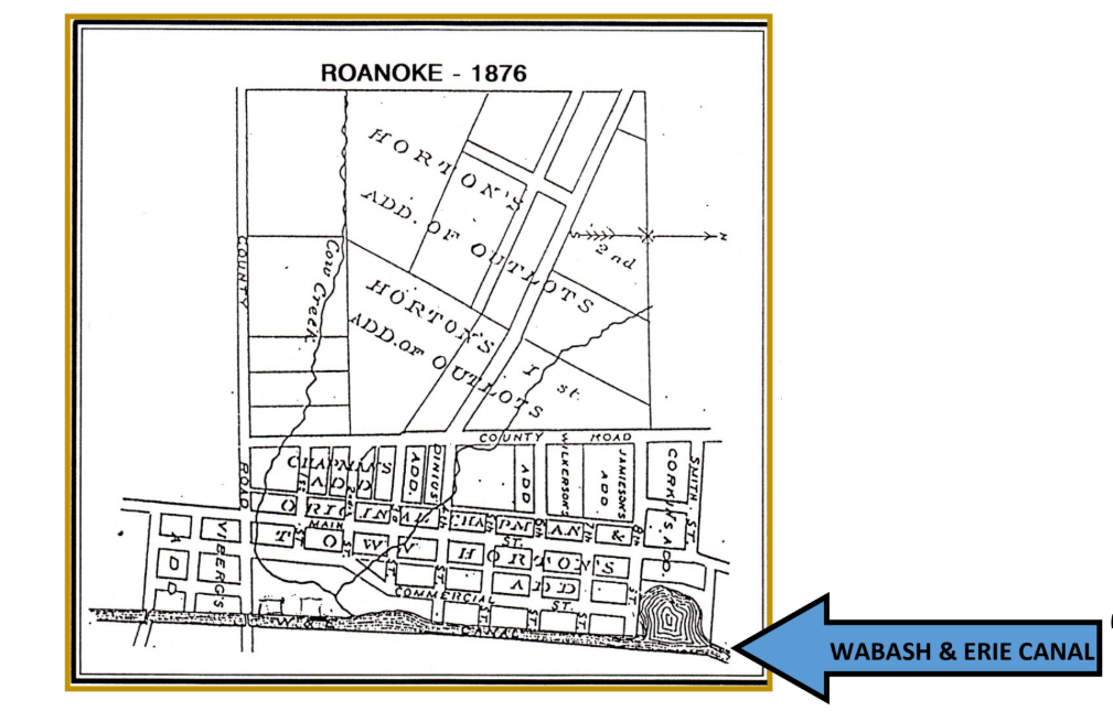
Culvert No. 36 located in Roanoke was then reached by the boats. It passed Cow Creek under the canal. This large wooden arch of 18 feet chord, semicircular, because of its size and shape could not be submerged. The arch timbers had been exposed to the air. Williams said the timber thus situated under a moist bank of earth, was not subject to rapid decay and he believed that the arch could stand 3 or 4 years longer and then be rebuilt of stone. The head walls needed repair within two years. Today this culvert passes McPherren’s Creek beneath it since Cow Creek has been diverted.
By 1835 the Wabash & Erie Canal reached Roanoke that was 12 miles southwest of Fort Wayne, Indiana and 9 miles northeast of Huntington, Indiana. It was a one day pull from Fort Wayne and offered barges a pull-off room for a night’s lay-over.
In 1837 Jarred Darrow arrived. He was one of the earliest settlers to the area.
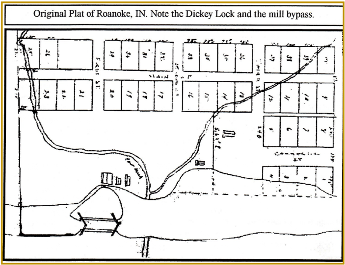
Roanoke also had Lock # 4 (aka Dickey Lock). Williams noted that this was the first lock west of the summit level at Fort Wayne. It had a 10 foot lift and was built upon the wooden frame plan. It was renewed in 1843 about 4 years before his report and was in good order. He thought it would last probably 4 or 5 years longer without much expense—gates will last 3.
In 1838 surveys were made for the first legally established road. It went through the township in a northeasterly direction from Huntington to Fort Wayne. Today’s its known as Fort Wayne Road.
Between 1840-1847 the area’s population swelled. It included a large number of persons belonging to the United Brethren Church, the Methodist Church, and the Lutheran Church.
By 1845 Roanoke’s citizens saw the need for a schoolhouse. It was built two miles north of town by the Wesley Chapel. Then another school was built on Main Street, near Sixth. Later this old frame building was moved to the corner of High and First Streets to make room for the first masonry school building in town, which was used until the fall of 1925. A mysterious fire destroyed the building on May 14, 1926. Another new building was erected on Vine Street on farmland donated by Marvin Richards and opened on September 8, 1925. It was 183 feet long by 137 feet wide, could accommodate 300 students, and had an auditorium that was 68 feet by 70 feet with a 34-foot ceiling and movable seating for 1,000 people.
In 1846 Roanoke’s citizens petitioned for mail service. Its post office was established on June 4, 1846 with Leonard Bilby postmaster. Shortly thereafter, on October 13, 1846, Theodore V. Horton took over the position and ran it for four years. The Rural Free Delivery Service was established on July 1, 1902 with two routes that were each two miles long. Its first carriers were Frank A. Milner (RR1) and Jesse V. McTaggert (RR2).
In 1847 Lemuel G. Jones built Roanoke Mills. It led to Roanoke becoming a prominent shipping point. Roanoke Mills and its store formed the nucleus of a flourishing settlement. Ownership of the business changed hands several times. In February 1850 George W. Chapman bought out his partner Theodore V. Horton and became sole owner of the mill, its store and property. Chapman immediately made plans to subdivide the property into lots and drew up a Town Plat.
The plat consisted of 40 lots, eight on Commercial Street next to the canal, and four blocks with eight lots each on Main Street between Vine and Fourth. The first four lots bordered the Wabash & Erie Canal and were quite small. The others ranged in size from 100 x 25 feet to 93 1/2 x 25 feet. The plat was filed on September 11, 1850 according to and article in the sesquicentennial edition of The Roanoke News.
The Indiana Herald of July 24, 1850 carried the following: ROANOKE TOWN LOTS AT AUCTION
The subscriber will offer at public Auction on Tuesday the 12th day of September, at 10 o’clock A.M. at Roanoke Mills, Huntington county, Indiana, a large variety of building Lots for private dwellings, Warehouses, &c., &c., as comprising a Town Plat, which he has surveyed and will on or before that day of sale have properly located for examination.
Roanoke is situated n the Wabash and Erie Canal, fifteen miles from Fort Wayne and ten miles from Huntington, in the center of a fertile, healthy and rapidly populating portion in the Wabash Valley as perhaps could be mentioned, and none surrounded with so many inducements for men of business or of leisure, to make large or small investment in business operation.
The face of the Flouring Mills, now in operation, being propelled by a never failing water power, are enabled to grind at all times during the most excessive droughts, and they cannot be excelled for making Flour of the very best quality—while other Mills in all directions for a great distance , cease to operate in a common dry season, is one of the strongest inducements in connection with the fact of obtaining Land in all respects for soil, locality, and easy access to good market, for a rapidly growth of population, capitalists, mechanics, and all who wish to avail themselves of advantages and future emoluments of a western Town, which in all traits of locality and favorable features for business operations, would do well to give the attention on the day of sale. Sale Positive.
Conditions—one-third cash in hand, one-third payable in six months, and the balance in twelve months, in notes of hand secured on the Lots. Title indisputable. GEORGE W. CHAPMAN Roanoke, July 17th, 1850
By 1848 European-American settlers began arriving.
In 1850 Roanoke was founded. It had become a prosperous commercial center. Lock #4 led to the establishment of hotels, mills, stables and warehouses. The village became known as one of the best trading and shipping points on the canal.
About that time Killhsoohkwa (“sun woman”), the granddaughter of Chief Little Turtle lived in Roanoke. The last full blooded Miami Indian Princess better known as Kilsoquah was considered to be “the last of the Miami tribe” by the local citizens. The town has honored her.
“In 1853, a boat landed at the lock of the Wabash and Erie canal about 50 yards southwest of the present interurban station in Roanoke. The boat came from the east and at Bethlehem, Ohio, it took on a family consisting of a father, mother, one sister and two brothers, the younger brother and the author of this sketch then being nine years old.” wrote Dr. S. Koontz in 1921 Roanoke Review. “When we landed at Roanoke, or what then was better known as the “Lock,” we found a thriving frontier village of from one hundred to one hundred and fifty people. The town like the city of Rome was situated midst its seven hills, all densely covered with a luxuriant growth of mammoth forest trees—oak, ash, walnut, hickory, beech, elm and maple and various other kinds in the fruits of which the settlers were fully dependent, as if more interested than in their meager corn crops, for the fattening of their hogs depended largely on a bountiful crop of the various varieties of nuts, the most important of which was the acorn and the beech nut.
“The town was inhabited by a sturdy variety of families from the east who had emigrated westward to find cheaper lands and homes. Many of whom we recall. Martin Bash and Aunt Katy who conducted a dry goods and grocery store and Ruban Ebersole, the druggist at the locks who daily issued out quinine to those afflicted with plague. At one time it was said that there were but two families in town who did not have from one to many cases to the dread disease. Daniel Welsh had a small grocery on the east side of the lock. His consisted mostly of the boat crews and Indians. T.V. and Frank Horton, who gave much of their time to land speculation and later on built a factory for the manufacturing of all kinds of woolen goods and for the time being did a thriving business….”
Later, F. S. Bash wrote on article entitled “Family’s History Mirrors Early Roanoke Life” for the Huntington Hearld Press of September 30, 1929. It is a story of how Bash was born in Roanoke and was a friend of Christopher C. Mulkins, a neighbor boy and great artist, who get together to reminisce. Mulkins asked, “Do you remember the big Indian who lived in the reservation a mile or two southeast of town? His name has gone from me, but I can see him as if it were but yesterday. He was a great fighter and had never been whipped until one day at the Dickey Lock he met his Waterloo most unexpectedly and from a source he had not dreamed of. I happened to be an eye witness to that encounter. Several of us boys had gone to see Captain Bolinger’s boat go through the lock. The Indian was there, a man of giant build with the strength of an ox. His acknowledged championship made him overbearing, insulting, abusive and chesty. The two men were standing just inside of old Dan Welch’s grocery at the edge of the tow path. Word passed between them and quick as a flash Bolinger hauled off and knocked the Indian flat on his back, then fell upon him and beat him unmercifully until the big fighter nearer dead than alive, wheezed Enough! It was whispered that what made the initial blow of the captain such a knockout was the fact that he had an iron weight from the scales in his hand. It was weeks before the Indian fully could appear on the streets again and when he did so, he was a changed man. He was through offering insults. His conceit hade been taken out of him by Captain Bolinger, who was crowned a hero all along the line of the canal.”
The arrival of the railroad brought a close to the canal heyday, but Roanoke continued to prosper. Main Street became a commercial and retail center that served its growing population and the area’s countryside. Store owners had established a reputation for fine goods at fair prices. Augustus Wasmuth and E. E. Richards, fostered economic growth through business and banking.
In 1873 John H. Barr circulated a petition to the county commissioners for incorporating the town of Roanoke and the right to form a municipal government. The ordered that an election be held on January 8, 1874. The result was 75 for and 9 against. The town was named after Roanoke, Virginia.
“Merchandise in Roanoke Always Gives Satisfaction” was its slogan in the 1920s. The community was sustained through the hardware store, pharmacy, restaurants and automobiles.
Roanoke did experience a decline in retail activity after World War II. Changes in transportation, marketing and merchandising occurred everywhere throughout America at that time. In contrast to earlier times, stores began closing on Main Street.
In the 1990s a revitalization of Roanoke’s historic downtown occurred.
In 1994, on July 4, the Roanoke Area Heritage Center (the museum) officially opened in the old bank building on the corner of Main and Second Street. The museum was formed by a group of local resident to promote Roanoke heritage. It is now located an 102 W. First Street and has a canal exhibit.
Sources
Web-sites
discoverroanoke.org—out story
enwikipedia.org-wiki-Roanoke_Indiana
Historic Roanoke-Roanoke Public Library (Indiana)
Bash, F. S. “Family’s History Mirrors Early Roanoke Life,” Huntington Hearld-Press, September 30, 1929.
Bates, K.M. Map and Profile of a portion of the Ohio and Indiana Canal System, 1936.
Koontz, Dr. S. “Pioneer Days in Roanoke Canal Days,” Roanoke Review, 1921.
Schmidt, Carolyn I. Wabash & Erie Canal: From the Forks to Paradise. April 12-14, 1996.
Frog Follies
Carolyn I. Schmidt
The frog is the mascot of the Canal Society of Indiana since they were in the canal from its beginning and are still there today. The following frog stories have previously been published in the Canal Society of Indiana Newsletters of March 1998 and July 1998. They are included here for your enjoyment.
The Frog and the Canal Boat Captain
Back in the 1890s, a retired canal boat captain was reminiscing one day as he walked along the silent towpath of the canal that had provided him with his livelihood and considerable happiness in days gone by. Now holding only stagnant water where it held water at all, the canal had become home to marsh grass and cattails, dragonflies, mosquitos, and frogs — lots of frogs. Slightly bent and sorely wrinkled by age and weather, he recalled the happy times on the canal—how he came to be the master of his own boat, which plied the Wabash & Erie Canal from Lafayette to Toledo carrying grain from the West, manufactured goods from the East and travelers in both directions.
His thoughts wandered from the peaceful journeys through dense woodlands and bountiful farmlands to the stops made for conducting his business at the many bustling canal towns on the Wabash & Erie. And how could he forget the star filled, pitch black nights; the cool crisp autumn mornings; and the stifling summer heat filled with the relentless whine of mosquitos. Now and again, his reminiscences took him back to times spent in the taverns of Lafayette and Fort Wayne enjoying the camaraderie of his fellow boatmen and his customers, and on occasion, in his formative years, flirting with the pretty girls of the town. He stopped to let these visions fill his reverie. Ah, what priceless portrait of his youth resided in those memories of his life on the canal.
Walking on, he reluctantly allowed these thoughts to retreat to their private places in his memory. Suddenly, he heard a small voice crying, “Captain, Captain!” The old man stopped and turned to see if he could locate the source of the voice. “Down here! Down here!” said the voice with an obvious sense of urgency. Looking down, he saw only a small, green Leopard frog at his feet. “Pick me up,” said the frog with a touch of annoyance in its voice. The old man, now sure that he’d heard what he thought he’d heard, gathered the frog into one of his toil gnarled hands and returned to his slightly stooped upright position.

The frog, satisfied with its present circumstances, began to talk to the old man in an ingratiating manner. “Turn me over and rub my belly” said the frog, “and I’ll turn into a beautiful young lady. The old man, remembering again the pleasures of earlier years, considered this unusual offer for a few moments, and then somewhat wistfully, but without comment, put the frog into his pants pocket and continued his stroll down the towpath.
The frog, dismayed by this turn of events but not to be ignored, cried out, “Hey! Hey! Didn’t you hear me? Get me out of here.” The old man, with notable recalcitrance, retrieved the now bewildered frog from his pocket and gave it another opportunity to speak. “If you’ll turn me over and rub my belly,” the frog began, but the old man interrupted. “I know,” he said, “You’ll turn into a gorgeous young lady. It’s a thought not without temptation,” he said slowly, “ but at my age, I think I’m probably better off with a talking frog,.” Whereupon he returned the frog to his pocket and continued on his solitary way once again reminiscing about the glorious days gone by.
The Frog and the Princess

Once upon a time, a beautiful, independent, self-assured princess happened upon a frog in a pond. The frog said to the princess, “I was once a handsome prince until an evil witch put a spell on me. One kiss from you and I will turn back into a prince and then we can marry, move into the castle with my mother, and you can prepare meals, clean my clothes, bear my children and forever feel happy doing so.”
That night, while the princess dined on frog legs, she kept laughing and saying, “I don’t think so.”
The Chesapeake and Ohio Canal from
Washington, D.C.
Ronald V. Morris
On the third weekend of May 2026 we attempted our annual hike on the Chesapeake and Ohio Canal, but this time we did it in the spring. Friday, the first day of the hike along the towpath of the Chesapeake and Ohio Canal, was the most difficult due to logistics. Gregg, his brother Brent, and I endured a motorcade, street barricades, and traffic congestion before we could find a place to park and then find the trail. We almost gave up, but after walking from Cumberland, Maryland to Harpers’ Ferry in previous years we really wanted to hike more of the trail. We found the zero marker on the tidal lock on the Potomac River. The trail was blocked and detoured for a restoration project, so we traveled up the hill in Georgetown and observed from the detour where the trail made a bend before a row of locks that raised the level of the canal from the river.
A big restoration project was seemingly in progress repairing the first five locks with treated and repaired wood, tight doors, crisp masonry work, and prism development. We found the Georgetown Visitor Center closed and attempted the ancient art of window peaking with little success. It looked like it had been closed for a while, and it never showed on our phone navigation. The canalboat was parked a little upstream from the visitor center in the canal waiting for the restoration to be completed and the water restored. There were lots of original buildings along the canal in Georgetown including canal related buildings and row houses.
We are men of a certain age with more hearing loss than we are willing to admit. We cannot quite hear the little trill of a bicycle bell anymore, and we need signs on our back reading, “Old deaf men walking—yell loudly” or for bicycles to carry a Chinese gong so we can hear them. We found the site where workers winched canal boats from the canal to the Potomac River with large counterweights and a track system to bypass the congestion of Georgetown. The first structure beyond Georgetown was the Abner Cloud house, a massive masonry structure on the canal. We hiked past lockhouse six, which was restored to the 1950s, the time when Justice Douglas was making his walk to champion the historic nature of the park. We also saw the first dam on the Potomac River for the canal. Turtles clustered on logs in the watered canal, and I saw families of Canada Geese with their fluffy young both on the trail and in the water.
We also walked past lockhouse ten, which was restored to the 1930s, after taking a moment to eat lunch on the walls of the lock and tumble. We learned from an interpretive marker that in the 1930s the Civilian Conservation Corps. repaired the first twenty miles of the canal. This was still mostly watered except where maintenance was being performed. At Seven Locks there was yet another restoration project of the locks and prism with the men all in white suits and the ominous sign on the fence declaring sewer overflow stay away from water. I do not know the story, but it does not sound as if the canal has always been treated well. We completed the twelve-mile hike to Anglers for our first day.
Lockhouse Twenty-Five
Usually on the trip we used a tent and camp along the canal, but on the last trip we learned about the lockhouses. There were seven restored lockhouses along the canal, three of them with modern plumbing, electric heat, and air conditioning. We were looking for a more authentic canal experience, so we selected the lock keepers’ house at lock number twenty-five. It was a great idea for adaptive reuse, and it came with a welcome quartet of deer. The privy, flashlights, shutters, picnic table, firewood, and fire ring were all provided.
The ruins of a warehouse and another structure sat next door, part of a small town which included a tavern store, and ferry. Since the United States Army camped here, Thadeous Loew launched his observation balloon to watch Confederate troops at Leesville, Virginia, and the site experienced raids and counter raids during the war. The house was interpreted in the 1860s Civil War theme. The stone first floor was unfinished. The second floor was brick and whitewashed up to the paired chimneys excluding the green trim and wooden shingle roof. Each floor had two rooms with wood floors, plaster walls, no electricity, water, heat, or air conditioning. I loved it!
There were framed photos on the walls of lock keepers and soldiers from the area, framed Harper’s Weekly type prints from the war and canal era, framed quotations about the war and canal site from primary sources, and a Civil War photo of the site. In one room was a game table and directions for games, a braided rug on the floor, a deacon’s bench, and rocking chair. A blanket chest had scrapbooks on top of it including stories from the Civil War and the canal. In the other room was a table with a cluster of books on history, natural history, and a guest log. There was a table and painted chairs, a dry sink, and blue transferware plates and clear tumblers were in the pie safe.
The third floor had two beds in each room with blue stiped mattress ticking, woven cover, and a blanket at the foot of each bed. A rope trundle bed was under each bed also with a blue stiped tick mattress. The rooms had small tables with crocheted dollies and blue porcelain pitchers as well as small, framed mirrors on the walls. Each room also had a framed preservation square where the original paint color was on display. This was a really fun experience along the trail that was just different enough that it had a trace of adventure connected with it.
The Canal at Night Fall
In the evening, at lock house twenty-five, I walked to the river that was framed with trees opening to an undeveloped view of the Potomac. A wood duck and chick sailed away from me, and an Anhinga, a black snake-necked bird, took off over the water. When I got back Brent had a fire going and the smell of cedar hung on the smoke. As we sat around the fire the logs popped pleasingly and sent showers of sparks into the air while an owl called repeatedly, “who-ah, who-ah.” The insects of spring performed their evening calls as the fireflies punctuated between the fire and the forest inviting the stars to come join them in pulsing and shining.
Saturday
Saturday, the second day of our walk along the canal, and the builders of the canal created tall masonry walls to hold the canal on the hill high over the Potomac River. We came to a tour boat that looked like it had been mothballed and modeled from an old photo which showed the covered passenger seating on top of an old canal boat.

Photo by Bob Schmidt — Fall of 1992
The tavern at the Great Falls Tavern Visitor Center grew from a two room lock house with two additions to become the center of a turn of the century D. C. tourism industry. I looked at the books in the gift shop, but I was not about to carry a purchase on the trail.
The multiple locks needed to pass the falls remained well maintained, but they were drained either for maintenance or in preparation for the tourist season.
Photos by Bob Schmidt – Fall 1992
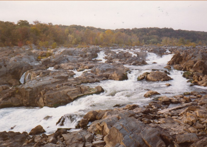
Our ancestors had no idea how heavily the towpath would be used. There were crowds of people enjoying the canal while walking, jogging, bicycling, floating, and fishing. The walk to Olmstead Island in the center of the Potomac took us over some of the rapids and through the great masses of rock at Great Falls. The plunging rapids created agitating foam from the Potomac River, and the hydropower potential was impressive. George Washington was correct in assessing the risk posed to navigation by this obstruction and suggesting a canal to bypass the feature.
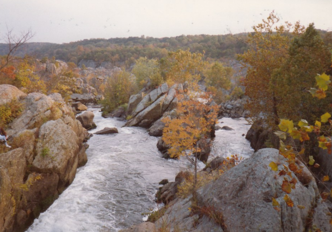
Photos by Bob Schmidt – Fall 1992
The broad pool of the canal allowed us to walk past lockhouse twenty-one restored to 1916 and lockhouse twenty-two restored to interpret the early operation of the canal from 1830-1840. It seemed to us that closer to D. C. there were many more of these restored lockhouses than we had seen on our earlier hikes. It also seemed as if there were fewer camp sites and those locations had little car access. We found a non-canal related site that was interesting, a Potomac water intake modern structure with an interpretive panel about the watershed. It was definitely worth a look as we walked the ten miles.

Photo by Bob Schmidt — Fall of 1992
Sunday
Sunday was an eight-mile walk with no canal features once we left the Senaca Creek Aqueduct and lock until we reached lock twenty-five and the lock keepers house at Edward’s Ferry. The Senaca Creek lock and aqueduct were built together, an uncommon feature. The aqueduct had serious damage, half of it was missing, but the remaining half had been stabilized. The stone here and at any places in the previous day looked like the same rock that was used in the Smithsonian Institute. The walk was shady with intermittent water in the prism.
Lock twenty-five was in pretty good shape with some damage on the upstream side of the lock. A National Park Service flyer that I picked up at Great Falls described granaries called warehouses for marketing grain from inland to the sea. My friends are some of the most curious people that I know. They want to see similarities and differences in the construction practices. We read all the signs, and they take photos documenting the trip for future evaluation.
It seems to me that interesting people like to explore. My friends are always looking at how the canal was built, by whom, and when. Why did it make life better for people? There are only two more days to hike on this trail before my friends, and I complete the walk from Cumberland to Washington, D.C.. I hope that we can return in the fall; it is always a good adventure. Perhaps that is why I like the Chesapeake and Ohio Canal so much. In a standardized and mass-produced world here is an artifact that was bult by individuals working together to solve a common problem. For me, the Chesapeake and Ohio Canal certainly makes my life better as I continue to explore.
Hutchen’s Lock?
Don’t Believe All That You Read

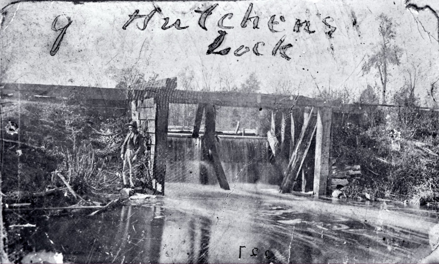
This photograph was posted on Facebook with comments over it that said it was by far the oldest, sharpest picture that has been seen of Hutchen’s lock prior to its being blasted during the reservoir war. On previous copies of this photo the person was barely visible because it was blurry.
The lock was located at the corner of High Road and Canal Road. George Hutchens, the lock keeper, lived about a quarter-mile north on a lane between the Klender farms. An old board was found back there with his name on it. The old house was there until about 1974.
There is a marker at the corner of High Rd (CR 77) and Canal Rd (CR180), West of Junction, Paulding County, Ohio. Nothing remains of the lock now.
Since this picture did not look like a lock to CSI headquarters, we contacted Jerett Godeke, a CSI director who wrote the book about the Reservoir War, and asked him what he knew about this lock. This is what he said, and CSI headquarters agrees with him.
“After digging through my book and other documentation… that is not the feeder bulkhead/gate or the lock. That is most likely the reservoir’s east waste weir! The photo would be the correct orientation for that. Looking back on the evidence, there were apparently two waste weirs (three if you count the inflow channel from Banks Lock).
“Excerpt from my book: “Furthermore, the water feeding into the reservoir was greater than the canal needed, thus overflowing the reservoir via the waste weir and flooding more land east of Six Mile Reservoir. Not helping the matter was that the drainage ditches east of the reservoir were impeded by debris and timber…” (Public Meeting in Paulding,” Defiance Democrat, June 1, 1867. 2.)
[Jerett Godeke, The Reservoir War, 17.]
Outreach Events & Programs
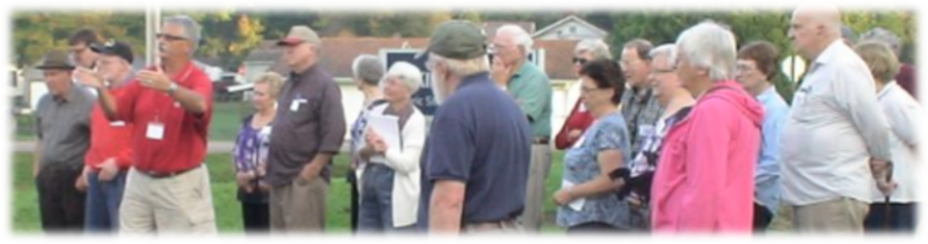
Mini Pioneers at Fowler Park
Sam & Jo Ligget
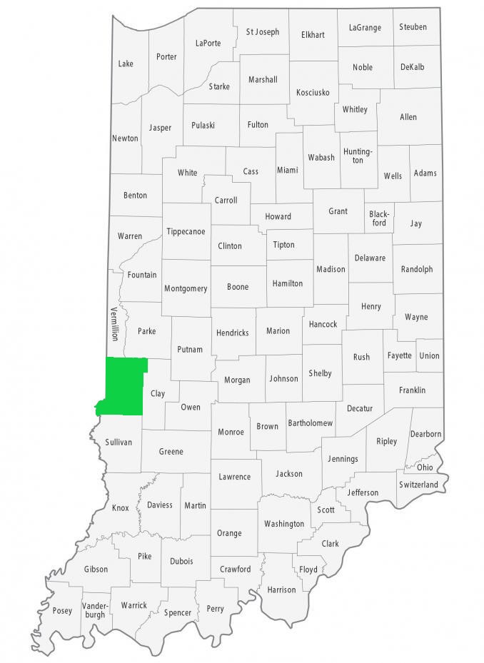
This spring Sam and Jo Ligget have spoken to 2 school groups in the Pioneer Village at Fowler Park, Vigo County. These visits were coordinated by Tavia Hedrick of Vigo County Parks and Recreation.
Timbers from Wabash & Erie Culvert 151 are stored at the park near a covered bridge built a couple years before the canal. The bridge originally stood over Honey Creek and witnessed the digging of the canal a few yards to the north. Depending on weather, the students sat in the bridge or outside by the timbers.
The first group was Edgewood Elementary School from Ellettsville, IN, on April 27. There were 232 second graders and a multitude of chaperones. It was a chaotic morning because buses arrived late. We think most of the 10 groups managed to hear something about canals! A packet of written material was sent back to school for teacher use.
On May 7, 35 kindergartners from Farmersburg, IN (Sullivan County), arrived. They were divided into 5 groups, each with an adult. We explained what a canal is. Out of the 5 groups, 4 thought it was a boat, which was a closer answer than we often get! We read A Full Hand by Thomas F. Yezerski, which is about a young boy helping his father on their canal boat. It has good illustrations of canal features.
The students from both schools visited other stations in the pioneer village, had a picnic lunch, and played at the playground before returning to their schools.

Williamsport’s Sign Is Up
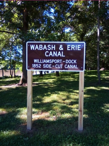
CSI headquarters received this photo from Terri Wargo, President of the Warren County Historical Society, of the CSI sign placed in Williamsport near the Wabash River in the background. Canal boats were lowered into the river from the Attica side-cut, poled across the river to its west bank at Williamsport and then loaded or unloaded at a dock. Although the sign was installed in May, we just recently received the photo.
Bodine Displays His Canal Lock
Anne Bodine

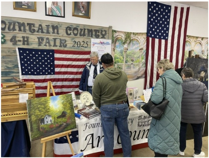
Fountain County, Indiana had a celebration at the local fairgrounds on May 2, 2026. They displayed the lock that my husband, Terry Bodine, built. He wasn’t able to stay the whole day, but Henry Schmitt, CSI member from Covington, Indiana, said he answered all sorts of questions about it the rest of the day.
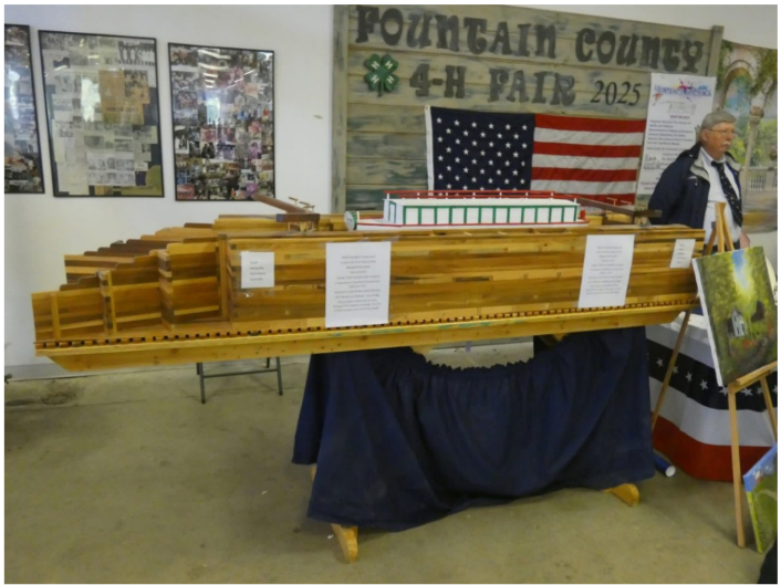
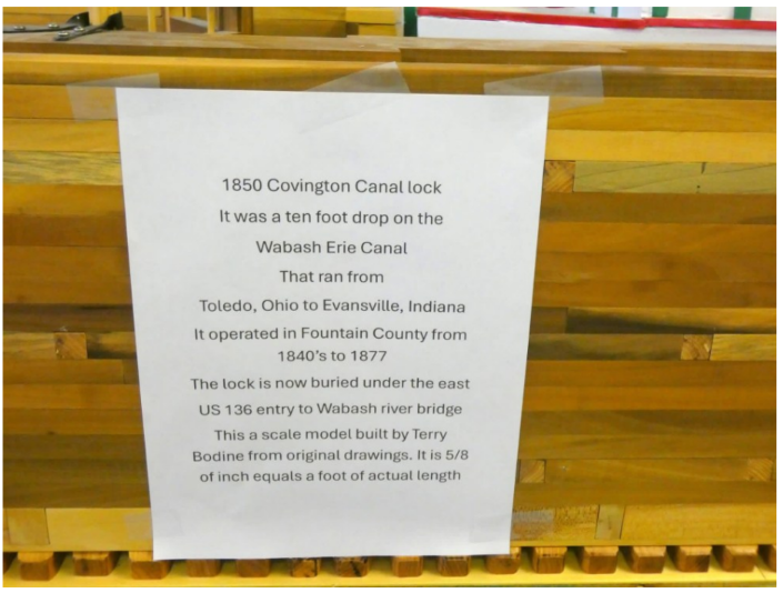
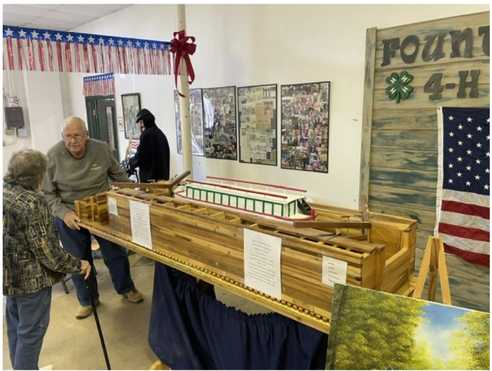
lowered boats on the Wabash & Erie Canal.
Delphi News

Historic Cabin Dedicated at Wabash & Erie Canal Park
Mike Tetrault, Executive Director Carroll County Wabash & Erie Canal Association
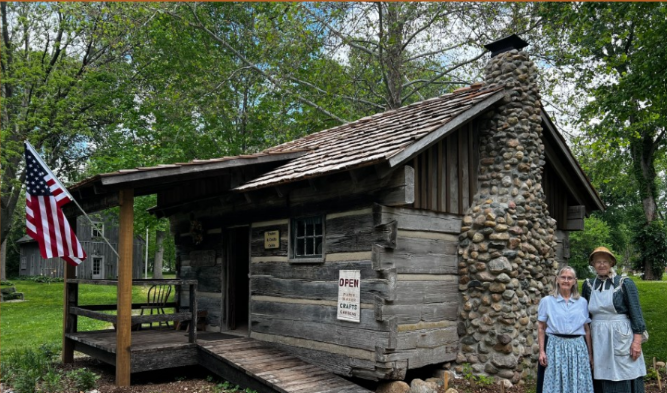
The Wabash & Erie Canal Park in Delphi, Indiana, held a dedication of the Deer-Crone Cabin, a one-of-a-kind piece of living Indiana history, on Saturday, June 6, 2026, at 2:00 p.m. The public was invited to attend and be among the first to explore the cabin in its new home within the park’s Pioneer Village.
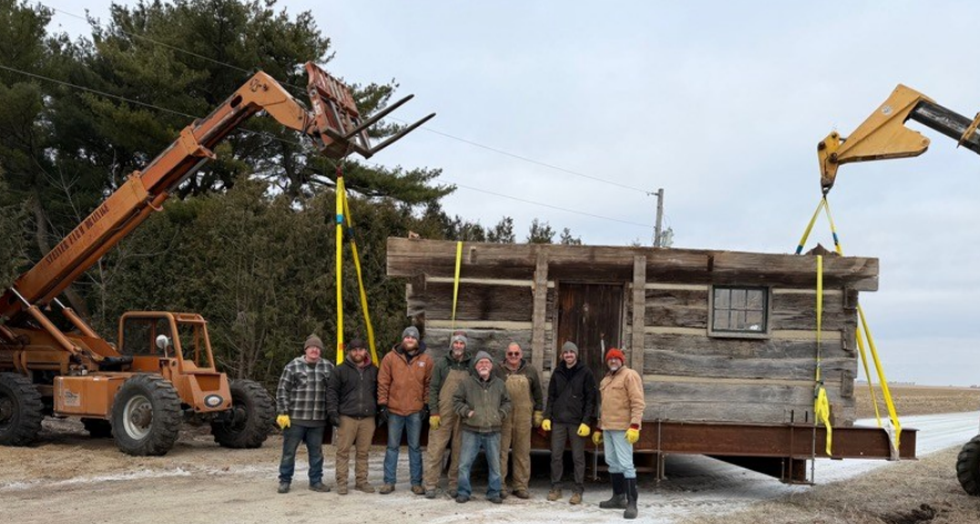
The cabin was originally constructed in 1830 by Urial Deer in Fountain County, standing as a testament to the craftsmanship and resilience of the state’s earliest settlers. In 1870, Boyd Crone gave the cabin new life through careful restoration, relocating it to Warren County where it stood for more than fifty years.
When the property was sold to new ownership the future of the cabin was uncertain. Rather than see this irreplaceable piece of history lost, the Crone family donated the cabin to Wabash & Erie Canal Park, ensuring it would be preserved for generations to come. The cabin’s relocation to Delphi was made possible through a generous grant from North Central Health Services (NCHS), administered by The Arts Foundation.
With an interior measuring over 200 square feet, the cabin posed some challenges to move over 50 miles to its new home. The roof structure was removed from the building, and the two resulting sections were loaded and hauled to Delphi.
Once at Canal Park, the cabin underwent an extensive renovation thanks to Peter and Linda Cooper’s contribution of funding, time, and expertise. The cabin has been transformed into the park’s new Trades & Craft Cabin, a hands-on history destination within Pioneer Village. Improvements include a new cedar shingle roof, a covered porch, an accessible ramp entry, electrical service, and a new fireplace and chimney.
More Students Than Ever Visited Canal Park

This past spring, on several days each week in April and May, Wabash & Erie Canal Park welcomed approximately 1,000 students for guided school tours, perhaps the busiest spring season it its history! Groups traveled from across the Wabash Valley and beyond, with schools representing Fort Wayne, Lafayette, Williamsport, Rensselaer, and many other communities.
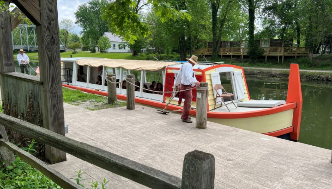
Students enjoyed a full day of hand-on-history, including a ride on the canal boat, a guided tour of the interactive museum, and visits to several Pioneer Village destinations where they could try their hands at broom-making or weaving on an authentic loom led by expert docents and tradespeople. The also had time to play on the canal playboat and enjoy a picnic lunch.
From the Whitewater Valley
River Takes Out Whitewater Canal Trail
Carolyn I Schmidt
Once again we learn of destruction to the Whitewater Canal Trail caused by the Whitewater River flooding it and cutting out the bank. A little over a month before, it destroyed some of the trail’s exercise equipment. It continues to be a battle just like in the canal era when freshets [flooding] destroyed the Whitewater and Cincinnati & Whitewater Canals’ aqueducts, culverts, dams, locks, and property due to the steep drop in elevation in the Whitewater Valley.
On May 28, 2026 Cassie Garrett posted the following pictures and text on Facebook:
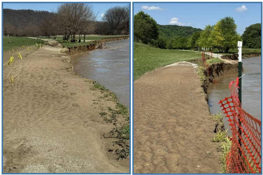
“These photos show the same section of the Whitewater Canal Trail at the east end of Metamora just over two months apart.
“I took the first photo of the trail on March 12, after flooding damaged a section and eroded the riverbank to the edge of it. Afterward, the trail was rerouted through the grassy area several feet from the old portion to keep it open.
“I took the second photo today after March 27’s flooding. The river has continued to move toward the rerouted portion of the trail, taking out the old section and causing significant erosion along the relocated section as well. If you look closely at the May 28 photo, you can see both trails. The small section along the river is part of the original trail shown in the March 12 photo. The wider gravel path in the foreground is the current relocated trail.
“I’ve reached out to both the Indiana Department of Natural Resources and INDOT regarding the continued river movement, the impact on the trail, and any long-term plans for stabilization or repairs.”
Canal Society of Indiana
News and Programs
Huntington W & E Swing Bridge
Craig Berndt
I recently found the following canal related pictures. Does anyone know the location of the second one?
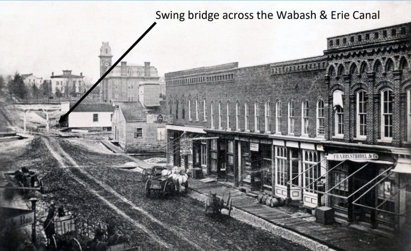
Picture found in the Huntington Library by Craig Berndt
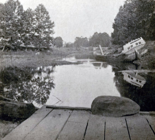
the Huntington Library by Craig Berndt Location unknown
Upcoming Events
| Date | Event |
| August 29, 2026 | Daviess County Historical Society, Washington, IN Dave Kurvach presents canal program |
| September 19, 2026 | Canal Society of Indiana’s Fall Symposium and Tour, Bloomfield. IN Public Library |
| November 14, 2026 | Canal Society of Indiana’s Board of Directors Meeting, History Center, Terre Haute, IN |