

Daniel S. Salsberry
By Carolyn Schmidt
Daniel S. Salsberry was born in 1785 to Peter Salsberry in Somerset, Pennsylvania.1 In 1810 at age 28 he was living in Erie, Erie County, Pennsylvania. In 1817 he moved to Springfield, Jefferson County Ohio and lived on land that his father Peter Salsberry got in the Military District. The 1820 census shows him at age 35 living in Jefferson County, Ohio.
In 1824, Daniel, age 39, married Mary Ann Dagan, age 21, in Ohio. She was born on March 1, 1803 in Pennsylvania. They eventually had twelve children:
Elizabeth Salsberry Long (1823-1870) married Jesse Long on 8-28-1849
John Peter Salsberry (1824-1897)
Sarah Salsberry Hensley(1825-1913) married Benjamin Hensley
Jonathon Salsberry (1827-?)
Mary Ann Salsberry (1829-1913)
George Washington Salsberry (1830-1890)
Andrew Jackson Salsberry (June 1832- Nov. 1913)
Susan Caroline Salsberry (1834-?)
David Salsberry (1836-1907)
Martin Van Buren Salsberry (1838-1913)
William K. Salsberry (1840-1911)
Delilah Salsberry (1845-1900)
All were born in Ohio except for Delilah, who was born in Indiana.
Sometime prior to the 1830 census Daniel and his family moved to the southeast quarter of section 18 in Crawford Township, Coshocton County, Ohio. He is shown on the 1830 census at age 45 and the 1840 census at age 55 living in Coshocton. Perhaps while living in Coshocton he gained experience working on either the Ohio & Erie Canal (opened in the area around 1830) or the Walhonding Canal (built 1836-1842) that are located near there.
Around 1844 Daniel, age 59, moved from Ohio to Indiana where Delilah was born. They lived in Marion, Owen County, Indiana.
In Indiana Daniel worked on the Cross-Cut portion of the Wabash & Erie Canal. Construction of this canal had resumed after the trust was established on July 31, 1847. Although original construction of this portion had begun in 1837, it had stopped in 1839 due to the Panic of 1837 and Indiana’s financial problems. By 1847 much of this earlier work had decayed and had to be rebuilt in Clay County. Marion (Marion Mills), the town in which he lived, was just east of the southeast corner of Clay County west of Clay City.
Daniel was killed while working on the Cross-Cut’s2 construction in 1848. County histories do not tell how he was killed. Canal projects in Clay County at the time included work on the Birch Creek aqueduct, feeder dams on Birch Creek or the Eel River, several locks and canal prism construction.
At the time of his death Daniel, age 63, his wife Mary Ann and children were living in Marion, Owen County, Indiana. His will was probated there. In his will his heirs were Andrew, David, Delilah, Elizabeth, George W., John Peter, Jonathon, Martin V. B., Sarah, Susan, William and widow Mary Ann. The administrator of his estate was his son, John P. Salsberry.
Mary Ann Salsberry and children continued to live in Marion after his death as shown in the 1850 census. Most of them had moved to Sullivan County, Missouri by the 1860 census. Mary Ann Salsberry, age 77, died in Missouri on May 13, 1880. Find-A-Grave #39752912
1Peter was the brother of Christopher Salsberry (1750-1847) and his wife, Catherine (1770-1846), who also had a son named Daniel. These two Daniels are often confused in family trees as both of their wives were named Mary Ann. The other Daniel was married to Mary Ann Hill. Both she and her husband died in Ohio.
2Ancestry family trees say he worked on the Whitewater Canal, but that is wrong. His home was by the Wabash & Erie Canal. Also the Whitewater Canal was completed in 1847.
Sources:
Ancestry.com
http://boards, ancestry,com/thread.aspx?m,v=flat&m=1289&p=loalities,northam,usa.
http://trees, ancestry.com/tree/14195557/person/88682059, medix/3?pgnum
http://trees, ancestry.com/tree/2438182535?ssrc=
Complete Probate Record Books 1,2 & 3 for Owen County, Indiana 1829-1849, page 199.
Daugherty, Karlene. Salsberry Family History & Genealogy Message Board on Ancestry
Death Certificate for Andrew Jackson Saulsberry (Salsberry) Missouri State Board of Health.
Hill, N. H. Jr. History of Coshocton County, Ohio: Its Past and Present. Newark, OH: A. A. Graham & Co., Publishers, 1881.
- S. Federal Census: 1820, 1830, 1840, 1850, 1860
General Instructions to Superintendents of the Wabash & Erie Canal, Indiana, 1849
These instructions were given by Jesse Lynch Williams, Chief Engineer, to the following Superintendents of the Wabash & Erie Canal at that time when it extended from the Indiana/Ohio state line to Lodi, Indiana:
District 1 O. Bird, Fort Wayne Ochmig Bird see Biographies on CSI website
“ 2 Mr. Holman, Huntington (Peru) Solomon Holman see Biographies on CSI website
“ 3 C. Carter, Logansport Chauncey Carter see Biographies on CSI website
“ 4 J. Morley, Lafayette J. Morley
“ 5 John McManamy, Covington John McMannomy see Biographies on CSI website
ORDERS OF THE BOARD OF TRUSTEES.
Adopted at their Meeting in July, 1849.
“Ordered, That for the purpose of a more efficient supervision, the navigable portion of the Canal be divided into convenient Districts of thirty to fifty miles in length, on each of which there shall be placed a Superintendent, to continue in office during the pleasure of the Board, except as hereinafter authorized, whose duty it shall be to devote his entire time to the care and management of the Canal, under the instructions and supervision of the Chief Engineer, and such Superintendent shall reside, in all cases, at some suitable point on the line of the Canal:
That the Superintendents be appointed by the Board, and that in filling these stations, preference shall be given to persons having had actual experience as Engineers in the construction and management of Canals: Provided, such experience can be found combined with sufficient energy of character, and with habits of economy in the performance of Canal work; said Superintendents each to give bond to the Board, to be approved by the Resident Trustee or the Chief Engineer, in the sum of two thousand dollars, for the faithful performance of his duties, and the accounting for all moneys coming into his hands, and also to take an oath of office.
That for the purpose of superintendence, the Canal be divided into Districts as follows, to wit:
District, No. 1, to extend from the State line to Huntington, including the St. Joseph’s Feeder, distance 50 miles:
District, No. 2, from Huntington to Peru, distance 34 miles:
District, No. 3, from Peru to the lower end of the slack water near Delphi, distance 40 miles:
District, No. 4, from the slack water to the south bank of Flint Creek, including Wea Feeder, distance 32 miles:
District, No. 5, from Flint Creek to Lodi, including the Shawnee Feeder, distance 39 miles:
That the Chief Engineer, from time to time, furnish such record books and abstracts to the Superintendents, and give such instructions to them as he may deem necessary,—to show their various expenditures separately,—to produce uniformity in their accounts,—to make their duties easily intelligible,—and to combine efficiency with economy, previously consulting the Resident Trustee when they may conflict with any existing regulation for disbursements or other wise, and in all cases giving the Resident Trustee due notice of the same; and be it further ordered , that it shall be the duty of the Chief Engineer, on his passing up and down the line, to examine into the manner in which the Superintendents keep their books, papers and accounts, and to see whether, in all things, they have complied with his instructions:
That the estimates on written contracts for repairs be hereafter made by the Chief Engineer upon data and measurements, to be furnished by the respective Superintendents; subject, however, to the supervision, correction and control of the Chief Engineer.”
GENERAL INSTRUCTIONS:
GUARDING AGAINST BREACHES.
The guarding against and preventing breaches by incessant watchfulness, should be viewed by each Superintendent as his peculiar and most important duty. So vital is this point, and so essential it is to the revenues of the Canal, as well as to the interest of those engaged in transportation, that I feel constrained to give my views specifically and urgently under this head.
The Trustees expect each Superintendent to devote his whole time to the public service, keeping most of the time on horseback, and passing over his entire District as often as consistent with the more local duties of his station, watching closely the Canal and its banks. He will more especially and frequently visit all weak or exposed points, with a view of detecting, if possible, the earliest indication of a breach, and to guard against it.
Inclement weather can furnish no discharge from the duty of visiting personally the exposed points. In truth, the more copious the rain the more urgent is the demand for personal attention, that the waste gates may be opened, the guard gates closed, and the weak points noticed. The duty of vigilant watchfulness, especially during rainy seasons, should be impressed also upon the Boat Boss, and all others in their proper sphere. No one should be employed in the repair service who would shrink from any duty however exposed, when there arises an emergency demanding it.

Breaches are more likely to occur during or immediately after the falling of heavy and dashing rains. At such season the levels should not be suffered to rise above the ordinary stage, and to avoid such contingency, it is indispensable that the Superintendent be on the line for the purpose of shutting off the feeders, opening the waste gates, &c. And if attention be required in both directions at the same time, he should promptly employ someone to ride with the greatest possible speed in one direction, while he himself goes in the other. In such emergencies it will not answer to wait until the rain shall have ceased; if the rain threatens to be heavy, he should start for the dangerous points soon after its commencement. As such rains occur as often in the night as in the day, it becomes necessary that the Superintendent should train himself to be easily awakened by heavy rains. These requirements may seem to involve some exposure, but this belongs to the service, and an efficient Canal police cannot otherwise be maintained. If the Superintendent, from infirm health, be prevented from riding the line during the rain, he should by some previously existing arrangement, be able to send a person in his employment, or else some friend or neighbor under special instructions from himself. And in cases where there are exposed portions of the Canal so remote from the residence of the Superintendent as to forbid his reaching them in time, he should at all times have an existing and well understood arrangement, either with some Lock tender or other careful person, by which the opening or closing of gates, or other precautionary measures may be promptly attended to in time of heavy rains. With careful forethought and judicious arrangements by the Superintendent, and with reasonable vigilance and skill on the part of the Boat Boss and Lock-tenders under his direction, those Levels which are peculiarly exposed to breaches, can be prevented from becoming too full in time of heavy rains.
It will be seen that our Canal police is based upon the principle of expending time and money in a watchful supervision of the Canal when it is in good order, and in such precautionary measures as may be likely to prevent breaches, rather than in the greater cost of repairing them. “A stitch in time saves nine.” He who repairs a breach in the shortest possible time, is deserving of commendation, but to him who prevents the breach by timely forethought and watchfulness, should be awarded far higher praise. The Superintendent should not remain at home until he may hear that the Canal is out of order, but should travel the line daily, in the diligent search for something wrong.
On each repair District, there will be placed a repair Boat of suitable construction, with a regular force of from six to eight men, under the charge of a faithful and industrious Boss or Foreman. Such force to be employed as occasion may require in lining the banks, stopping leaks, strengthening weak or exposed points, repairing breaches that may occur, and generally under the direction of the Superintendent, in doing whatever may be necessary to maintain a good navigation.
REPAIRING BREACHES
On the occurrence of a breach, or any other obstruction which hinders navigation during the boating season, the most efficient arrangements should be promptly made for the repair of such breach, or the removal of the obstruction. In such instances, the leading object should be to put the Canal again in a condition to pass boats in the shortest possible time. And although no unnecessary expense should be incurred, yet in this case, the saving of time is of more consequence than the saving of money. In cases of great urgency, and where circumstances will permit, it may often be advisable to employ two sets of hands, one to work during the day and the other during the night.
In the case of a breach of considerable magnitude on any portion of the Canal, the Superintendent on the adjoining District nearest to such breach will aid in its repair with men and tools, so far as this aid may be compatible with the safety and proper management of his own District, of which he must be the judge.
On the occurrence of a breach, or other casualty, interrupting navigation, whether for a longer or a shorter period, the Superintendent will promptly communicate information thereof, briefly by telegraph, and more fully by first mail, both to the Trust Office and to the Chief Engineer, wherever he may be. And in all cases the Superintendent will be careful to keep an exact record of the time during which the navigation or use of the Canal may be suspended or interrupted by reasons of any breach, and to report the same to the Chief Engineer, and also to the Canal Office at the time.
As a general principle, it is recommended that all work, which, from its character and amount, and the time that can be allowed for its performance, is susceptible of being done by contract, shall be performed in that way. And where the amount of work may be too small to require a public notice or written article of agreement, the Superintendent can, in many cases, if a fair offer be made, give it out in small jobs under special agreement. The object in view is, that those who labor on the Canal shall, as far as practicable, be themselves interested in accomplishing the largest possible amount of work: and that they work by the day or month only, in case of a breach or bar which interrupts navigation, or in critical jobs which need to be done with great dispatch, or in the ordinary labor of the repair boats, stopping leaks, guarding against breaches, watching banks, &c.
Whenever there is time to allow of it, and the work to be done is of considerable amount, the Chief Engineer, in behalf of the Trustees, will give public notice of the work required, and the terms and the time of letting, receive proposals therefore, and award the contracts. For all contracts of considerable amount, say, over one hundred dollars, or thereabouts, a brief written or printed agreement in duplicate will be made out, and when approved by the Chief Engineer, will be forwarded by him to the Trust Office for consummation. Nothing herein is to be construed as warranting the least delay in repairing any breach, or taking out any bar or other obstruction, that may occur in time of navigation.
ESTIMATING REPAIRS
Breaches in the embankments which may occur during the suspension of navigation, and when dispatch is not so important, will ordinarily be repaired by contract, and the Superintendent is charged with the duty of laying off with a Level, and measuring accurately the quantity of earth to be replaced, and will report the same to the Chief Engineer. Breaches occurring during the season of navigation will, in like manner, be measured, (not however to delay the repair,) and the number of yards reported. For this purpose, and in order also to ascertain and preserve the true bottom of the Canal where it is liable to fill up, and for other like purposes, each Superintendent will provide himself with a Level and other necessary instruments, to be kept at all times in his District, and to be used as occasion may require.
MAINTAINING THE PROPER STAGE OF WATER
The Superintendent will give particular attention to the stage of water in the various Levels, endeavoring to maintain, at all times, the proper depth; and as the low water season approaches, should guard in time against any waste of water at the dams and other places, and will see that the Mills do not, in any case, draw water from the Canal when it is wanted for navigation. The passage of the proper quantity of water around each Lock for the supply of the Lower Levels, is a matter requiring systematic arrangement and frequent supervision. For this purpose the paddle-gates should not be used, (except in filling the Canal,) but the tumble or regulating weir, with which each Lock is provided, should be carefully adjusted, so as to pass the required quantity, varying the height of the weir, from time to time, as circumstances may demand.
When any portion of the Canal, or either of the repair Districts, may be dependent for its supply of water upon Feeders belonging to an adjoining District, the Superintendents of the respective Districts thus situated, will confer often with each other as to the quantity of water required for the lower District, and should maintain a correspondence by the daily Packet, or other wise, as more or less water may be necessary.
Fort Wayne, August, 1849, J. L Williams, Chief Engineer Wabash and Erie Canal.
Images of the Wabash & Erie Canal Heading North
Through Warrick County, Indiana
By David Kurvach, CSI director from Newburgh, Indiana
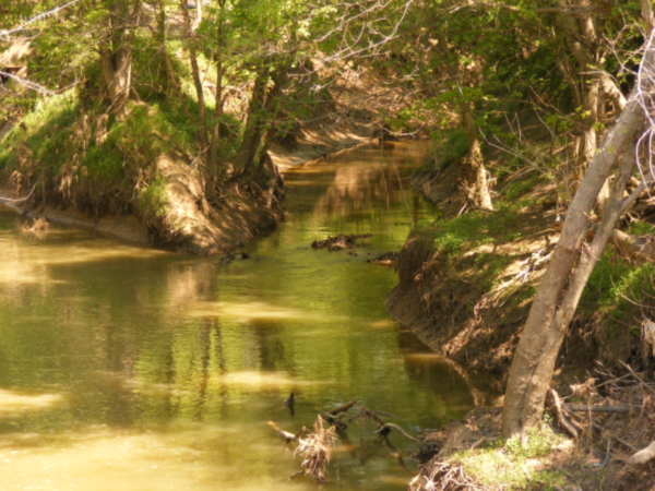
38°00’20.89”N 87°26’44.26”W
The canal location looking southwest along State Road 62 about 400 yards east of the Vanderburgh-Warrick County line. As along the same thoroughfare in Vanderburgh County, much of the canal is a modern, dredged drainage ditch, significantly deeper than typical canal depth of six feet. The rail line is also on the towing path.
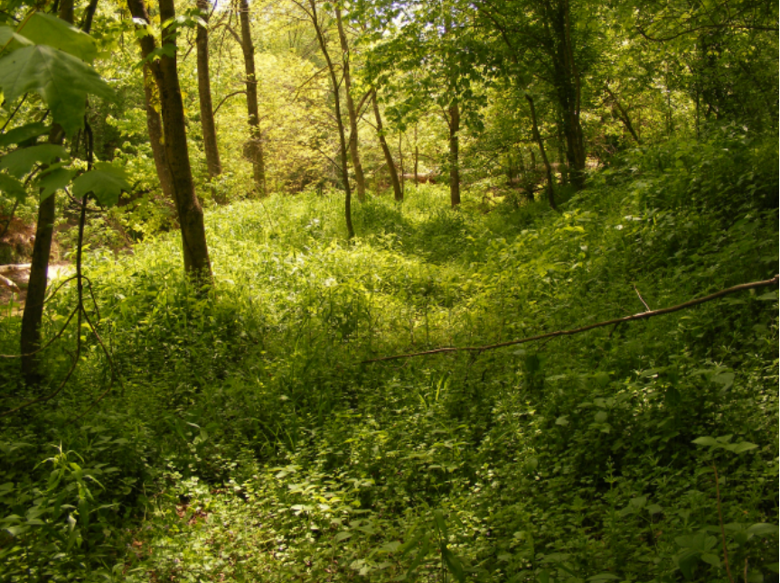
38°00’34.82”N 87°26’18.67”W
The canal location looking northeast along State Road 62 about eight tenths of a mile east of the Vanderburgh-Warrick County line. Here, weeds grow in the old canal bed giving a good impression of what once was here 150 years ago.
38°02’02.80”N 87°23’21.98”W
Cross section of the canal is visible as it adheres to the direction of Indiana State Road 62. The Wabash and Erie Canal follows SR 62 for about six and a half miles from the intersection of Green River Road in Vanderburgh County to about three-quarters of a mile west of Chandler, Indiana.
 38°02’05”N 87°23’17”W (the location on the plat map where Pigeon Creek and the canal are closest together)
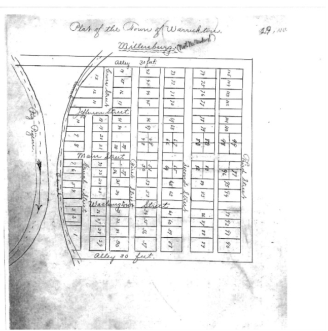
Copy of the original plat map for the canal town of Warrickton, located on Tow Path Road, about three quarters of a mile south of where it intersects Warrickton Road.
Obtained from the Warrick County Recorders Office. (Note: The plat of Warrickton is mislabeled and corrected to show it is not Millersburg.)
38°03’55.79”N 87°23’06.99”W
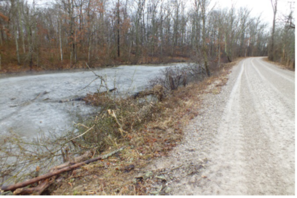
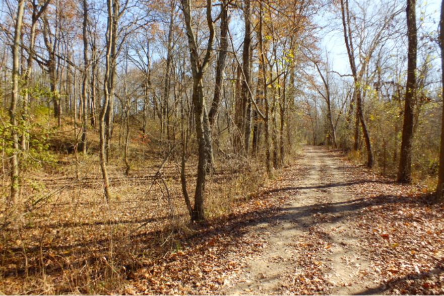
Preserved canal along Tow Path Road northwest of Chandler, Indiana. Tow Path Road is the Wabash and Erie Canal towing path that has since been modernized into a graveled vehicular public road that runs two-thirds of a mile. Preserved canal bed may be viewed along much of the road’s length.
38°04’12.73”N 87°23’12.13”W
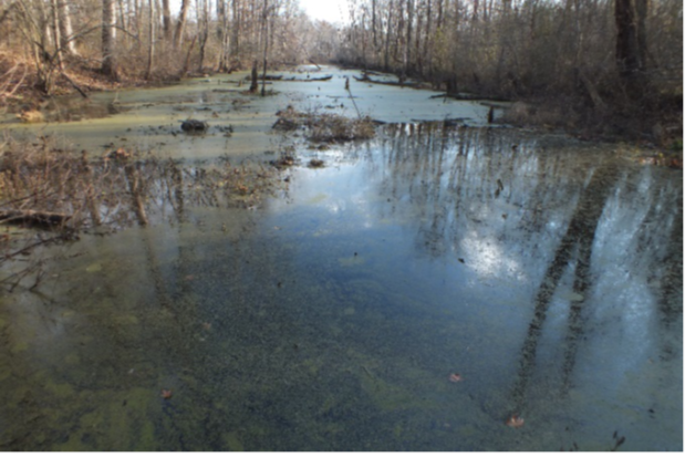
Preserved Wabash and Erie Canal at the northern end of Tow Path Road in Warrick County. This is about two tenths of a mile of uninterrupted, preserved canal and located about one tenth of a mile south of Squaw Creek.
Photos taken 1 December 2012.
38°04’18.28”N 87°23’16.09”W
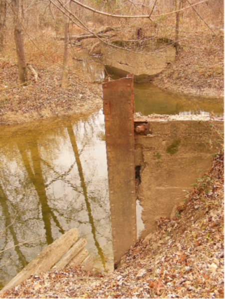
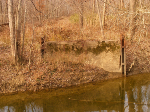
Photo on the left is from the northern bank of Squaw Creek looking south. The photo on the right is from the southern bank of Squaw Creek looking north.
The abutments pictured here are what is left of an iron vehicular bridge that once carried Tow Path Road across Squaw Creek. The bridge was built in the twentieth century and has little to do with the canal aside from moving traffic along the old towing path. This is no longer part of the public road.
This is also the location of Wabash and Erie Canal culvert 225, one of only a few stone culverts constructed south of Terre Haute. While the towing path and some of the canal bed still exist on either side of Squaw Creek, all traces of culvert 225 are gone.
My best guess is the culvert looked similar to the one that carries the canal over Silver Creek in Huntington County, Indiana. This can be viewed via the following link:
https://bridgehunter.com/in/huntington/bh42363/
38°04’19.74”N 87°23’17.14”W
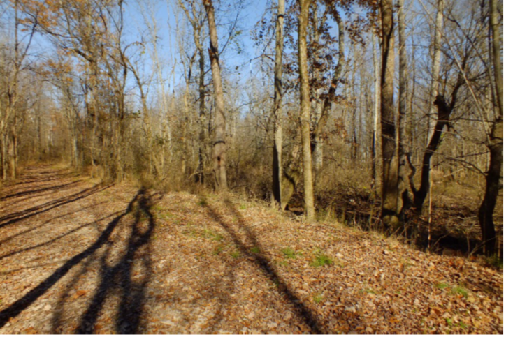
The towing path as it travels north of Squaw Creek. The canal prism is visible here (located behind the tree line on the right side of the towing path); it is shallow compared to the preserved prism south of Squaw Creek.
38°04’27.89”N 87°23’24.99”W
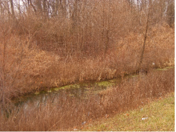
The towing path looking south of the old Squaw Creek Mine railroad earthworks. The shallow canal prism is visible to the left of the towing path road. The towing path and prism are not well preserved north of the railroad earthworks. This location is close to the platted town of Newark.
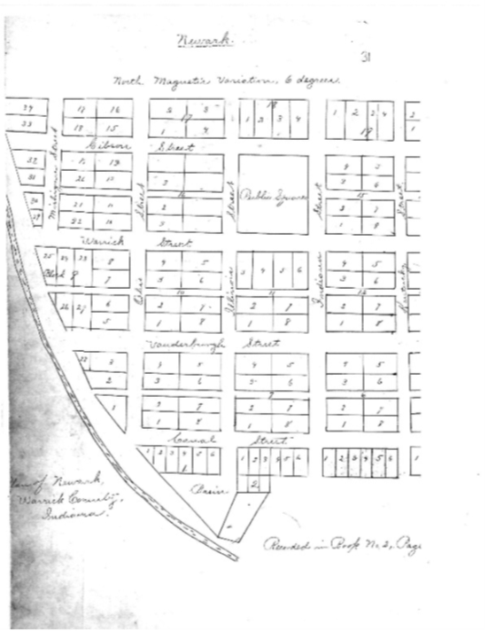 38°04’25.72”N 87°23’21.23”W (approximate location of the basin shown on the Newark plat map)
Copy of the original plat map for the canal town of Newark, located about a third of a mile southwest of the intersection of Wasson and Heilman Roads. Like many canal towns, Newark did not develop and disappeared from most maps by the 1880s.
Obtained from the Warrick County Recorders Office.
 38°05’50.99”N 87°23’34.41”W
(the intersection of Ditney Street and Boonville Street (now Boonville-New Harmony Road) or 100 yards west of the modern crossroads of Wasson and Boonville-New Harmony Roads.
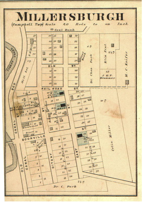
Plat map of Millersburg from the 1880 Historical Atlas of Warrick County, Indiana from actual surveys under the direction of B.N. Griffing published by D.J Lake & Company.
The Wabash and Erie Canal bed is noted on the left (western) edge of the town. The intersection of Boonville and East Streets is very close to the modern intersection of Boonville-New Harmony and Wasson Roads.
Also of note, the intersection of Boonville Street and the “Old Canal Bed” on the map is the location of Road Bridge 159, as noted in the 1853 Report on the Canal.
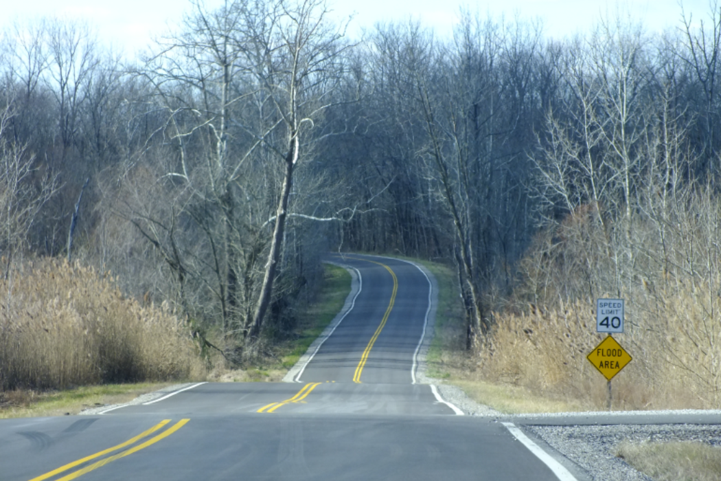
38°05’50.50”N 87°23’38.47”W
(location of the second dip in the road and the site of road bridge 159)
This is Boonville-New Harmony Road with its intersection with Wasson Road in the foreground. The second “dip” in the background is where Boonville-New Harmony Road “enters” the canal. In 1853, the roadway would have crossed the canal on road bridge 159.
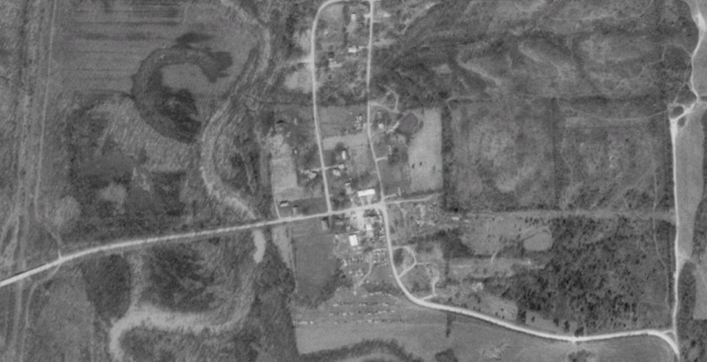
The two above images (File names WAR14a and WAR14b) show the stark contrast to how Millersburg, the only town in Warrick County on the Wabash and Erie Canal to survive into the twentieth century, was wiped out of existence so that it could be strip mined for coal. Only the cemetery remains today. (the ridge on the spur road southeast of the crossroads, 38°05’46.09″N 87°23’19.04″W)
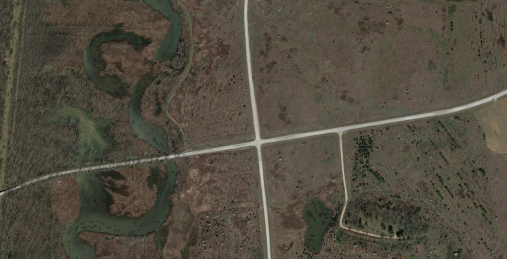
 38°07’48.07″N 87°23’57.53″W (Approximate location of the feeder between Pigeon Creek and the Wabash and Erie Canal)
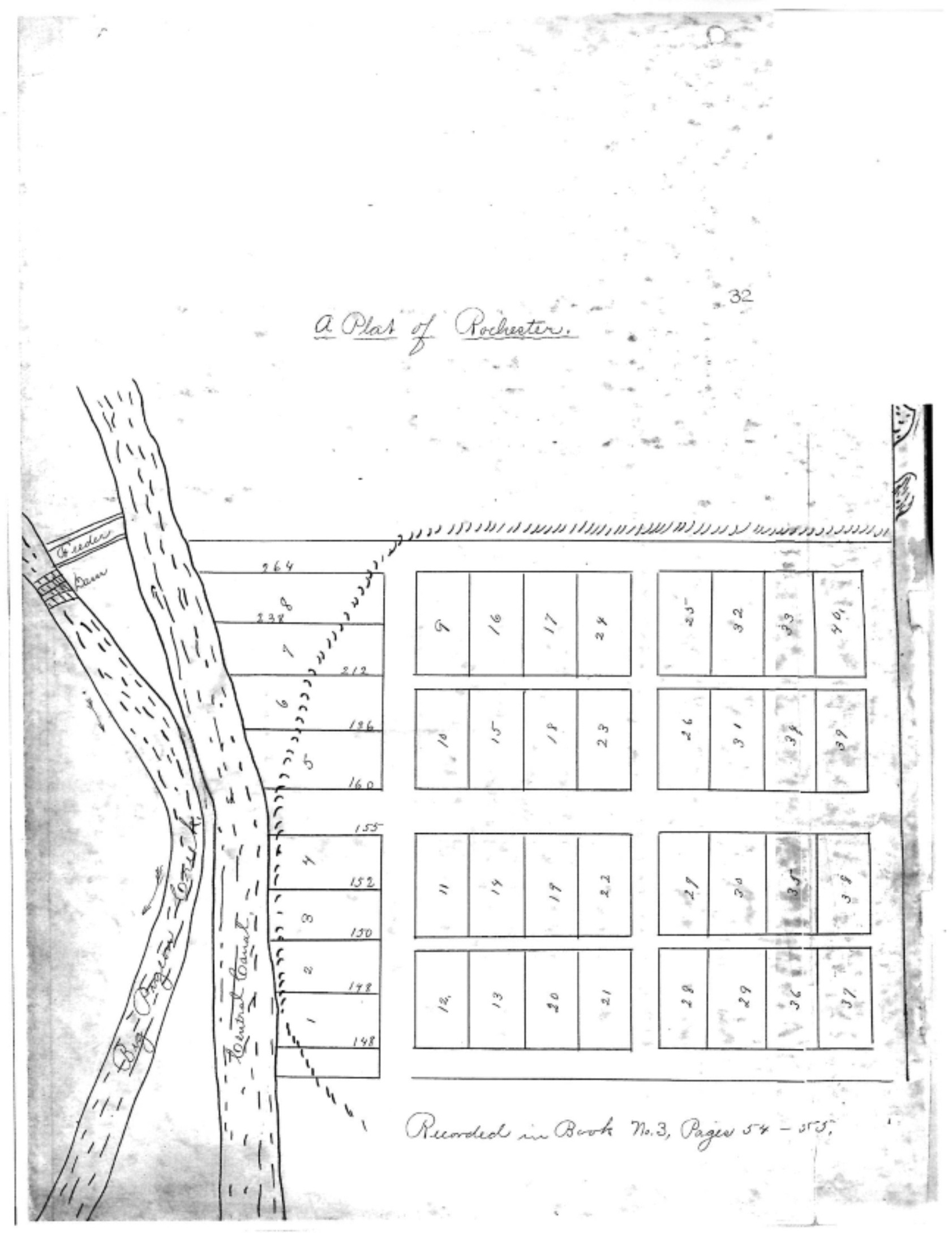
Copy of the original plat map of Rochester, located 3½ miles southeast of Elberfeld or about one mile downstream from where Seven Hills Road crosses Modern Pigeon Creek.
Also in the plat map is the location of the Pigeon Creek Dam and the feeder that connects to the canal (noted as “Head Gates” in the 1853 report).
Obtained from the Warrick County Recorders Office.
38°08’34.16”N 87°24’21.36”W
The berm side of the Wabash and Erie Canal just south of Seven Hills Road in Warrick County. There is a well preserved section of canal that runs south by southeast from Seven Hills Road to where it adjoins modern Pigeon Creek. However, there is a modern drainage ditch that has been dug through the middle of the canal to move water from Seven Hills Road to modern Pigeon Creek.
38°08’35.85”N 87°24’22.99”W
View of the Wabash and Erie Canal from the northern side of Seven Hills Road. While this ground floods easily, when it is dry, it reveals a well-preserved section of canal that stretches about half a mile north of Seven Hills Road.
38°08’38.39”N 87°24’24.25”W
View of the canal prism about a hundred yards north of Seven Hills Road (which can be seen in the background).
38°08’40.28”N 87°24’25.93”W
View of the preserved canal about 150 yards north of Seven Hills Road. A very nice, though shallow, section of the Wabash and Erie Canal runs about a half mile north of Seven Hills Road. Photo taken from the berm side of the canal.
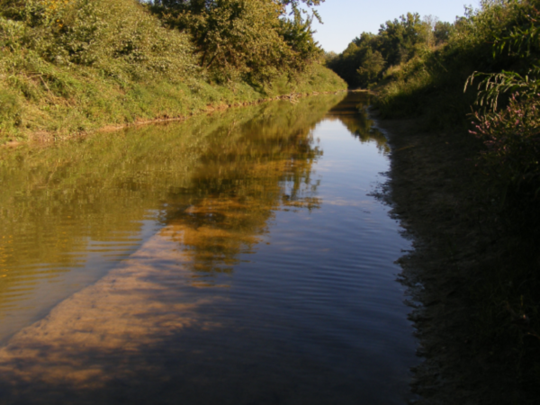
38°08’47.83”N 87°24’30.67”W
The towing path of the Wabash and Erie Canal about one quarter of a mile northeast of Seven Hills Road. The northern half of this half of a mile of well preserved canal becomes even more defined and stays watered throughout the year.
38°08’47.71”N 87°24’30.09”W
Preserved and watered section of the Wabash and Erie Canal about a quarter of a mile north of Seven Hills Road. This photograph was taken hanging off the edge of the towing path.
38°08’49.69”N 87°24’31.17”W
Preserved and watered section of the Wabash and Erie Canal about a quarter of a mile north of Seven Hills Road. This photograph was taken hanging off the edge of the canal berm.
38°08’51.97”N 87°24’32.56”W
Photos taken 1 April 2013.
The two above photos are the preserved, watered Wabash and Erie Canal about three-eights of a mile northeast of Seven Hills Road. They are views looking north (WAR23) and south (WAR24) from the same point on the towing path. Coal mines can be seen in the background. The area east of the canal has been heavily strip mined for decades, but as of 2018, has not encroached on this section of the canal.
Photos taken 1 June 2015.
38°11’38.57”N 87°25’29.26”W
The first photo is looking north from the State Road 68 bridge over what is now Modern Pigeon Creek, which formerly was the Wabash and Erie Canal. After the canal ceased operations, it was dredged several times between 1900 and 1990 in an effort to straighten Pigeon Creek thus clearing land for other use such as farming and strip mining and to control flooding. The end result is modern maps declaring this “Pigeon Creek” when it is not (Historic Pigeon Creek can be seen west of the bridge). To distinguish it from the Pigeon Creek that would have existed in 1853, we call this “Modern” Pigeon Creek. In some areas, of Warrick and Gibson Counties, Modern Pigeon Creek is the canal… some areas it is the original creek… and some areas it is neither. The second picture is detail of the mouth of Modern Big Creek. Dredging occurred on the tributaries of Pigeon Creek as well… Historic Big Creek would have crossed the canal further north of this point (Aqueduct 18 carried the canal over Big Creek) whereas Modern Big Creek empties into Modern Pigeon Creek formerly the Wabash and Erie Canal. Hence, this is not the site of Aqueduct 18.
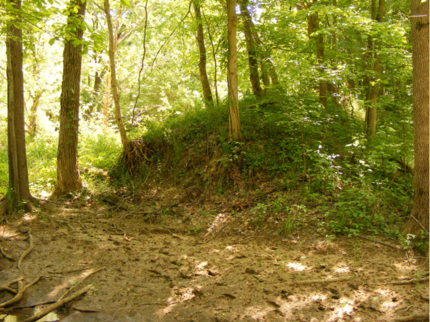
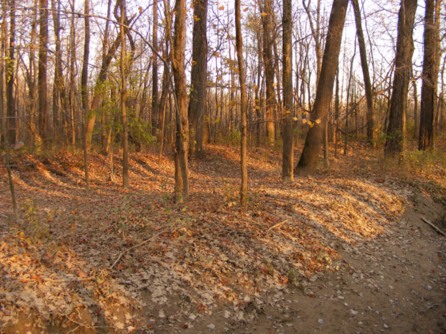
38°12’03.36”N 87°25’47.40”W
North of State Road 68, the western bank of Modern Pigeon Creek (formerly the Wabash and Erie Canal), there still exists a large mound believed to be the original towing path of the canal. This is a profile of the mound looking south.
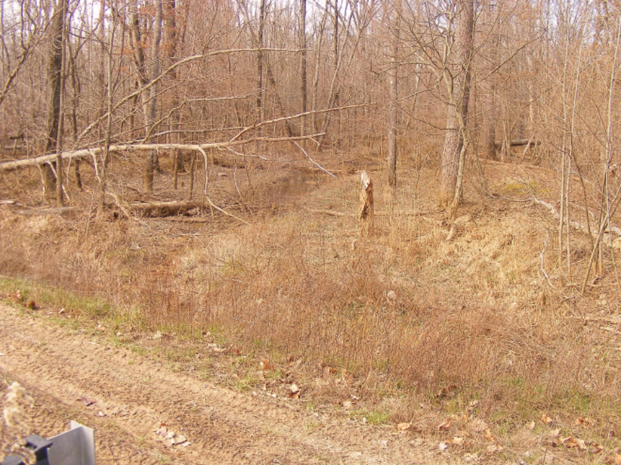
38°12’05.36”N 87°25’49.40”W
Here we see detail of the mound, which levels off in places before it descends into the dredged creek/canal. It is a theory of mine that this is preserved canal bed that was never dredged.

38°12’05.36”N 87°25’49.40”W
This is detail of what is believed to be preserved tow path along Modern Pigeon Creek formerly the Wabash and Erie Canal.

Photos taken 23 September 2013.
38°12’04.41”N 87°25’48.03”W
The Wabash and Erie Canal (now Modern Pigeon Creek) just north of the Gibson-Warrick County line. The canal emerges from the woods and into farmland at this point. The second photo shows several different dredges: you can see how one section is significantly deeper compared to the other.
Note: David Kurvach, one of CSI’s newest directors, has photographed and researched the Wabash & Erie Canal in Warrick county, Indiana for the past ten years (2009-2019). Here he has presented thirty-one of his many images pertaining to the canal along with GPS coordinates. This is a helpful tool for anyone wanting to walk or study the canal route through Warrick county. He has also prepared a spreadsheet showing all the canal structures within the county that we will publish at a later date. He has used the 1852 map of Indiana published by J. H. Collon, a topographical map of the Boonville quadrangle published in 1902 (reprinted in 1946), and a copy of the 1853 Engineer’s Report to aid in his research. In the future he plans to do a similar study for the Wabash & Erie Canal in Vanderburgh county.
Looking for the Lost Payroll
By Sam Ligget
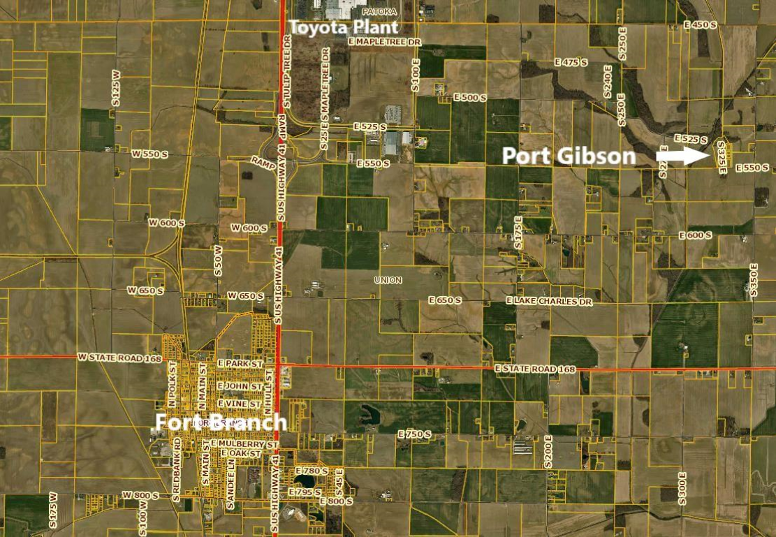
My wife’s Uncle Arnold Geiselman and her brother-in-law John Green, both Warrick County natives, claimed there was a lost treasure in Gibson County, Indiana. The treasure had to do with the Wabash & Erie Canal. While looking for canal-related stories among material in Wabash Valley Visions and Voices, I came upon a written version of this folklore.
Canal days in Gibson County—the search for the payroll at Port Gibson was written by S. C. Dixon of Evansville, Indiana with the consultation of Levi Lockhart of Princeton, Indiana. This article was written as a part of a WPA project to preserve local history. The year it was written is uncertain, but it probably was about 1936.
 Following is the story in its entirety reprinted courtesy of Indiana State University and Wabash Valley Visions and Voices:
The boss and paymaster of the Works at Port Gibson was Patrick Manning, who was a likable person of about 25 years of age.
A short time before one of the pay days Mr. Manning made a trip to Evansville for payroll money. Arriving at Port Gibson at dusk, he buried the money in the woods to prevent a robbery. During the night Mr. Manning was stricken with yellow fever and was dead within twelve hours. Just before his death his friends tried to get information concerning the payroll, which they knew was hidden in the woods. All he was able to tell was “white oak.”
After Mr. Manning was buried a digging party set out and every white oak tree in the neighborhood was inspected to no avail. If the money was buried it has never been found unless it was done secretly. However, in later years people have come to Port Gibson in search of the “pot of gold,” being directed by dreams and spiritual readings.
The latest expedition was only last year in 1935. An Indianapolis lumber company bought up lumber on the old canal right-of-way near Port Gibson. During his stay in the locality, the company’s representative heard the story of the buried money. Shortly after hearing this story he went to Indianapolis where he obtained the help of a geologist and with aid of his magnetic instrument they conducted another search. Whether or not they found the gold is uncertain, but at the junction of the canal and the feeder which are very prominent at that place is a large white oak four feet in diameter. The northern side of this tree was undermined by these men to such an extent that now it is dead.
How much could this “treasure” be worth? What was the form of the payroll? Was it cash, White Dog, Blue Dog, or Blue Pup? At the given pay rate for canal workers, this could not have been a large sum of money in 1935.
 Patrick Manning was indeed a very well-known construction contractor on the Wabash & Erie Canal. By all accounts, he was a just and honorable man. According to Gil R. Stormont in his History of Gibson County, Indiana: her people, industries and institutions, with biographical sketches of representative citizens and genealogical records of many of the old families, Manning hired a trusted man and bookkeeper by the name of Pat McTurbon. McTurbon was so good at his work that Mr. Ball, chief engineer on the canal, tried to lure him away from Manning with more money. McTurbon chose to stay with Manning. Two detectives from Scotland Yard showed up and claimed McTurbon was really a wanted thief named John Cecil. He had robbed an English nobleman of over half a million dollars’ worth of jewels. McTurbon got away.
If you happen to be in Gibson County around Port Gibson and see people digging around the bases of trees, it just could be they are looking for the lost payroll. Is anyone interested in another CSI tour to Gibson County? Oh, don’t forget your pickax and shovel!
Whitewater Canal Note
By Robert Schmidt
The Whitewater Valley Railroad received a Whitewater Canal note that is displayed in their railroad museum. John Hillman, WWVR president and CSI director, asked for more information about the note for this display.
The Cincinnati & Whitewater Canal was organized in Cincinnati on April 1, 1837 to build a 25-mile-long canal from the Harrison dam on the Whitewater River at the Indiana state line into Cincinnati. This note is identified as “canal scrip.” The reason for issuing the scrip was to keep the canal project proceeding during a period of economic hard times. Gold or silver specie was hard to obtain, especially in the West. Businesses and some banks were failing due to the recession of 1839. Therefore, the company issued notes to be redeemed in the future for the various services they required.
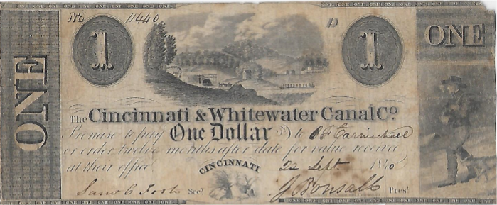
The scrip reads as follows:
The Cincinnati & Whitewater Canal Co.
Promise to pay One Dollar to B F Carmichael
on order twelve months after date for value received at their office.
CINCINNATI
The note dated 22 Sept 1840 is signed by the company Secretary Samuel C Foote and President Joseph Bonsall. The scrip is registered with the serial # 11440. Pictured on the right side of its face is a man walking with a dog. In the center is a local scene of a canal boat moving along toward a tunnel being constructed between Cleves and North Bend, Ohio with the farm of William Henry Harrison in the background. Harrison, at this time the Whig candidate for US President, donated the land on which some of the canal and all of the tunnel were being constructed. He was also an investor in the canal project.
Indiana stopped most canal construction in 1839. The Whitewater Canal was only completed between Lawrenceburg and Brookville.
This scrip was issued in 1840 for a variety of obligations. Note that there is no mention of interest, so why was the scrip accepted in payment of an obligation? The answer is simple, the scrip was to pay $1 for an obligation of perhaps 80–85 cents thus returning a handsome return to the lender if the issuer could pay after 12 months. Note that the scrip is numbered and registered by the Canal Company.
This piece of scrip was redeemed after the twelve month period by B. F. Carmichael. He has endorsed it on the back with his signature just like we endorse a check today.
Why would someone take this scrip and chance not receiving payment? Presidential candidate Harrison was an investor and the economic prospect for the canal looked good. Darius Lapham, the Chief Resident Engineer, concluded that this canal would produce 50% more economic value and revenue than the Miami Canal that had been completed in 1829 between Dayton and Cincinnati. He assumed that the sale of water power alone in the 17 ½ foot fall with about 90 turning mill stones would “be sufficient to pay the interest on the cost of constructing the whole canal.” Lapham’s plan did not include linking the two canals in Cincinnati but terminated the proposed canal at the foot of 5th Street in the city. This was just short of the junction with the Miami & Erie Canal and provided for a future connection at the lock between 5th & 6th Streets.
The initial financial backing for the canal also looked pretty sound. The State of Ohio bought $150,000 and the city of Cincinnati $400,000 of the initial subscription of $800,000 of capital stock. Individual investors purchased the rest. The financial panic of 1839 resulted in the issuance of scrip and the suspension of work on the main canal except for the tunnel, which was resumed in 1840. Perhaps that is why the tunnel is featured on the scrip face.
In 1836 Darius Lapham was assigned the project by Samuel Forrer, the Chief Engineer of that canal, to complete a survey of the proposed Cincinnati & Whitewater Canal. Lapham concluded that the canal could be 25 miles in length and that a tunnel would be required to pass under the ridge at Cleves, which was 109 feet higher than the bottom of the canal. Later he considered an open cut but concluded the tremendous excavation cost favored a 1,782 foot tunnel, 24 feet wide and 20½ feet high.
Groundbreaking for the canal took place on the William Henry Harrison farm on March 31, 1838. With great enthusiasm the work proceeded until the financial crisis of 1839-40. The canal contractor for the tunnel was S. & H. Howard & Company. Workers were paid 60 cents per day or about $18.00 per month. Bricks to line the tunnel were made on the Harrison property with about 100 workers involved in making 2 million bricks and tunneling. It is unclear when the tunnel was completed and work on the rest of the canal resumed, but by 1843 the Cincinnati & Whitewater Canal was opened for business. This was the same date that the Wabash & Erie was opened from Lafayette, Indiana to Toledo, Ohio. The Miami Extension from Dayton to Junction, Ohio wasn’t completed until 1845.
Indiana’s Whitewater Canal and Ohio’s Cincinnati & Whitewater Canal connected at the Harrison dam. With the opening of the Cincinnati and Whitewater Canal and Cincinnati’s pork processing plants, most of the Whitewater Canal’s traffic south of the Harrison dam was drained off by the new canal.
Why did Indiana allow this to happen when the outcome was predictable? When the Whitewater Canal was surveyed Indiana was faced with a high ridge at the state line south of Harrison. A choice had to be made whether to build a rail system over the hills, tunnel or make a deep cut through them, or place 7 miles of the Whitewater Canal in Ohio in order to reach the Ohio river. During the negotiations Indiana agreed to allow Ohio to access the dam at Harrison in exchange for a canal route inside Ohio.
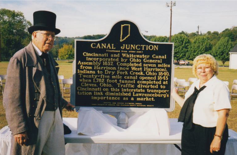
Harrison, Indiana funded by the Canal Society of Indiana and the Indiana Historical Bureau in September 1999.
Indiana Historical Marker – West Harrison IN
Side one:
The Whitewater Canal and the Cincinnati and Whitewater Canal joined in Harrison to provide better access to Cincinnati markets and Ohio River. Indiana Internal Improvement Act 1836 authorized Whitewater Canal; completed from Brookville to Lawrenceburg 1839. Nearby Dam No. 1 on Whitewater River created a pool for canal boats to cross the river.
Side two:
Cincinnati and Whitewater Canal incorporated by Ohio General Assembly 1837. Completed seven miles from Harrison (now West Harrison), Indiana to Dry Fork Creek, Ohio 1840. Twenty-five mile canal opened 1843 when 1,782 foot tunnel completed at Cleves, Ohio. Traffic diverted to Cincinnati on this interstate transportation link diminished Lawrenceburg’s importance as a market.
Flooding of the upper Whitewater Canal in 1846, 1847 and again in 1849 help to doom both canals. The Cincinnati & Whitewater Canal Corporation went into receivership on May 31, 1861. In January of 1863 the canal was sold to the Cincinnati & Indiana Railroad Company, which began laying track and was operational by December 13th of that year.
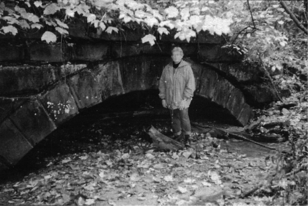
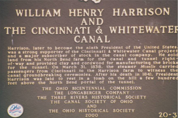
The canal scrip of the Cincinnati & Whitewater Canal helps us tell the story of these two canals in the Whitewater and Miami River valleys. In 2000 a historical marker was placed at the Cleves tunnel noting this unique canal structure.
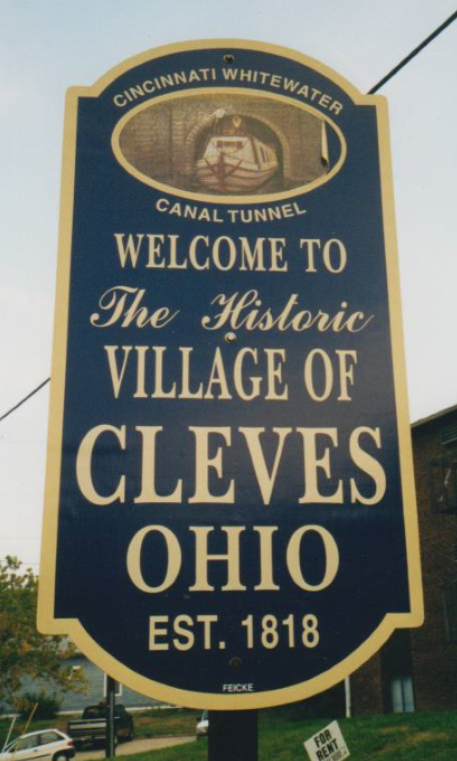
side A (south)
Harrison, later to become the ninth president of the United States, was a strong supporter of the Cincinnati & Whitewater Canal project and a major subscriber of stock in the canal company. He sold land from his North Bend farm for the canal and tunnel right-of-way and provided clay and cordwood for manufacturing the bricks for the tunnel. On March 31, 1836, the steamer Moselle carried passengers from Cincinnati to the Harrison farm to witness the canal groundbreaking ceremonies. After his death in 1841, President Harrison was laid to rest in a tomb on the hill a few hundred feet above the North Bend portal of the tunnel.
side B (north)
In 1837, Cincinnati merchants projected a branch canal to join the Whitewater canal at West Harrison, Indiana, with the goal of tapping commerce from Indiana’s Whitewater Valley. The major obstacle on the route was the ridge between North Bend and Cleves, just northeast of this site. Engineer Darius Lapham designed a 1,782-
foot tunnel through this barrier. Lined with brick made on site, the tunnel, 24 feet wide, and 20 ½ feet high, was the first canal tunnel in Ohio. Six workers died in it’s construction. The Cincinnati & Whitewater Canal opened in 1843 but was abandoned by 1856, after the main Whitewater Canal had been rendered useless by repeated
flooding. The canal tunnel was subsequently used as a railroad tunnel from 1863 until 1888, illustrating the progression of transportation technology in the mid-nineteenth century.
Canal Boat Ticket
This ticket for passage on a canal boat was found by Neil Sowards, CSI member from Fort Wayne, Indiana, on E-bay:
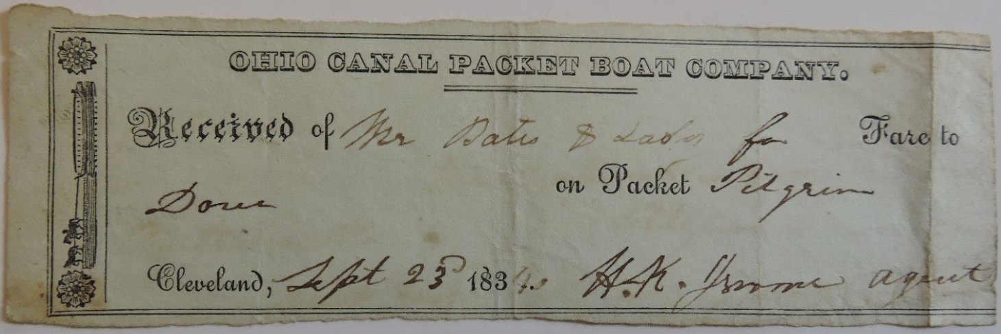
It is about 2.25 inches wide and 6 inches long. On the left hand side is a canal packet boat being pulled by two horses. The hoggee rides on the back of the second horse. The ticket reads:
Ohio Canal Packet Boat Company.
Received of Mr. Bates & Tabor for Fare to Dover on Packet Pilgrim
Cleveland, Sept. 23, 1834 H. K. Jerome agent
Unfortunately the cost of the ticket is not shown. This is the first canal boat ticket your editor has ever seen and assumes it is rare.
Zion Church Family Moved Via Canal Boat
On November 4, 2018, Phyllis Mattheis, CSI director from Cambridge City, spoke on All Saints Day about saints of Zion’s Lutheran Church in East Germantown, Indiana. Three families gave money back in the 1940s to fund the church’s Fellowship Hall located on the west side of the church. It is used often, even by people in the community.
One of these families was Mahlon and Lucy Boughner (pronounced Boofner). They were married in Pennsylvania in 1846, about the time that the Whitewater Canal was finished to Cambridge City, Indiana. The young newly married couple loaded their possessions onto a one-horse cart and drove it to Wheeling, West Virginia. There the couple sold their outfit and boarded a river boat for Cincinnati, Ohio. From there they moved by canal boat to Cambridge City.
For 53 years they lived on a farm north of East Germantown, where their two daughters, Elmira and Elizabeth were born. The two sisters never married. For the last five years of mother Lucy’s life, the three women lived in town. The parents must have been successful in life, as the family has an impressive gravestone in Zion’s Cemetery, north of the church. When Elizabeth died in 1939 a Memorial Fund was started with her bequest of $5,000. Over the years two other families contributed, so that the Fellowship Hall was built and dedicated in 1951.
As the oldest ELCA Lutheran congregation in Indiana, Zion’s congregation will celebrate 200 years in 2022.
Worship services for Zion’s Lutheran Church were first held in a log building. Then in 1833 a brick Federal style building was erected. Presently services are held in a Gothic style building that was erected in 1900.
Koehler Presents Programs
Jeffrey Koehler, Clay County Historian and CSI director from Center Point, Indiana, was busy during the early months of 2019 presenting programs about Indiana’s canals and interurbans that often ran on canal towpaths:
Jan. 14 “The Amazing Interurban,” Wabash Valley Genealogy Society 95 attended
Feb. 5 “The Amazing Interurban,” Plainfield Guilford Twp. Library 8 attended
Mar. 3 “The Amazing Interurban,” Paris, Illinois Historical Society 20 attended
Mar. 7 “The Wabash & Erie Canal” Plainfield Guilford Twp. Library 40 attended
He also discussed the whole canal system in Indiana.
CSI New Members
The Canal Society of Indiana welcomes aboard the following persons who have joined at the single/family membership level of $20:
- Margaret Griffin Ft. Wayne, IN
- William C. Helbing Fishers, IN
- Frank Butwin Perrysburg OH
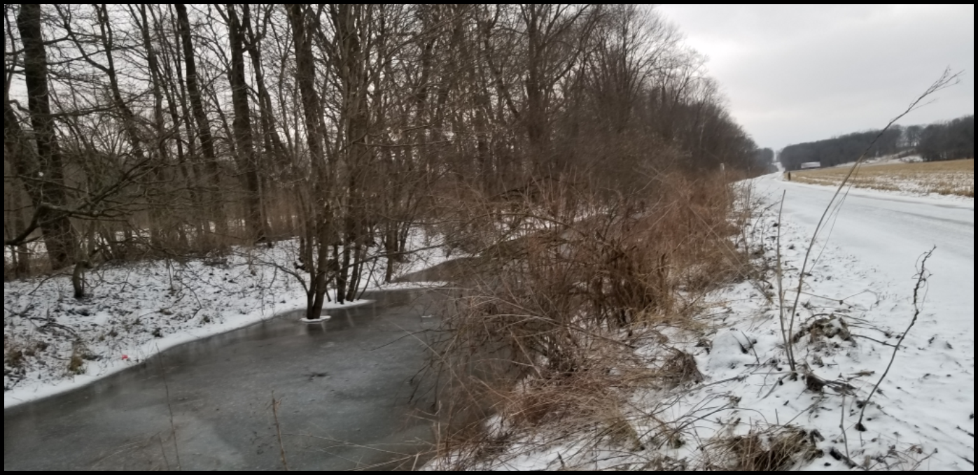
Flashback to Winter
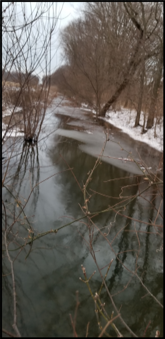
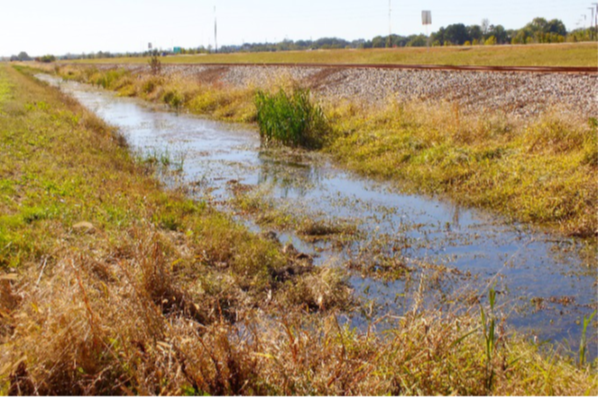
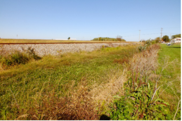
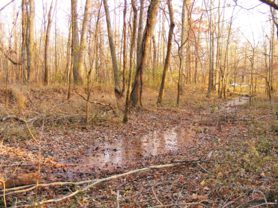
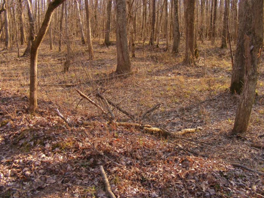
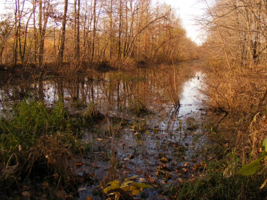
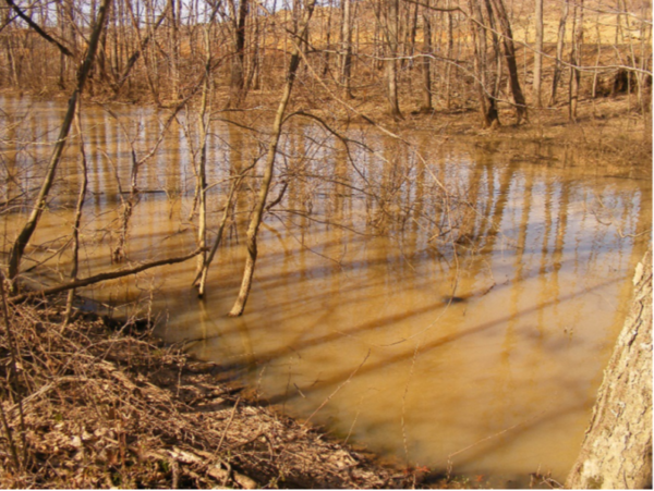
By the time you receive this issue of “The Tumble” we hope spring has sprung and bad weather is over. Shortly after the March issue was sent to be put on the CSI website, CSI headquarters received the following two photos from Robert Johnson of Cass county, Indiana. One good thing the past winter accomplished was producing enough water to make the bed of the Wabash & Erie Canal easily visible along Lewisburg Road between 1075 E and 1000 E in Cass county.
Bauer New MVHC Director

Carl Bauer, CSI life member from Fort Wayne, Indiana, will represent the Canal Society of Indiana on the Maumee Valley Heritage Corridor’s board of directors.
The purpose of the Maumee Valley Heritage Corridor, Inc., is to protect, enhance and interpret the natural, cultural, recreational, agricultural and historical resources of the Maumee River Watershed. The watershed includes the St. Joseph River and St.
Mary’s River and runs from Fort Wayne, Indiana to Toledo, Ohio and Lake Erie. It includes the following communities along the Maumee River: Fort Wayne, New Haven, and Woodburn in Indiana and Antwerp, Defiance, Independence, Florida, Napoleon, Texas, Grand Rapids, Waterville, Maumee, Perrysburg, Rossford, Oregon and Toledo in Ohio.
Raised just outside the canal town of Cincinnati, Ohio, Carl was both Junior and Senior High class president before attending Ohio State University in Columbus. In 1966 he earned a Bachelor of Industrial Engineering degree and was a member of Alpha Pi Mu engineering honorary.
In 1967 Carl married Barbara Laedlein. They have two sons.
Carl was employed at General Electric Company and after completing its 3-year Manufacturing Management Training Program, worked in its Mobile Radio Department. He then became an Industrial Engineering manager at Cincinnati’s Aircraft Engine Electronic Controls Department associated with GE Aircraft Engines. He served on the planning team for a new site for jet engine production in Ft. Wayne, Indiana implementing the “work cell” material flow for product manufacturing. In Ft. Wayne he procured robotic soldering equipment and improved a light-guided wiring system and material handling. Still later he became responsible for development/maintenance of labor time standards for product assembly. After General Electric sold its aircraft business to Lockheed Martin, Carl designed a Microsoft database system to efficiently ship non-product items from the facility. He retired from Lockheed in 2000.
Carl has rebuilt automobile engines, constructed several garages, served as facilities chairman at several churches, participated in Ft. Wayne Paint-A-Thons, helped build over 10 houses in Ft. Wayne for Habitat For Humanity, and volunteered for 14 weeks over 3 years to help rebuild homes in Slidell/New Orleans after Hurricane Katrina.
Carl is a member of the Canal Society of Indiana, ACRES Land Trust, Little River Wetlands Project, Fox Island Alliance, The Nature Conservancy, National Park Foundation, National Parks Conservation Association, National Wildlife Federation, and the Maumee Valley Heritage Corridor. In the past he participated in the Wabash River Heritage Corridor development. He is active in his church.
CSI members who previously served on the board are Tom Castaldi (3 years), Richard Kudner (board president), Bob Schmidt (8 years) and Carolyn Schmidt (12 years).
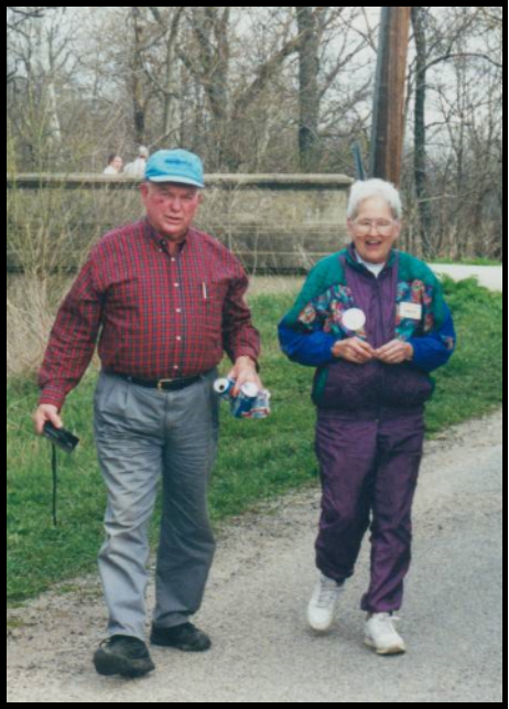
In Memoriam: Kenneth Leroy Baker
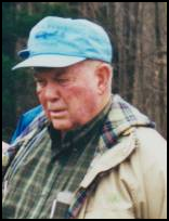
Ken Baker, CSI member from La Porte, Indiana, passed away on Wednesday, December 26, 2018 at Oak Woods Manor at the age of 92.
Ken was born to Elmer J. and Jessie I. (Rayburn) Baker in Medaryville, Indiana on October 16, 1926. He was a graduate of Purdue University, a retired dairy farmer, DHIA Supervisor and Pioneer sales representative as well as being an accomplished pencil artist and WWII Army Veteran.
He was married to Sarah “Sally” Jordan on September 7, 1952 in Wheeler, Indiana. She preceded him in death on October 9, 2005.
He was a member of Door Village United Methodist Church, Lions Club, Land of Lakes Art Alliance, Farm Bureau, Sunday Farmers, LP Row Crop Food Producers, Rumely Allis-Chalmers Heritage Center, Michiana Antique Auto Club, Pioneer Cemetery Commission, and many local and state historical organizations. He supported activities to enhance his community. He received the State of Indiana’s Sagamore of the Wabash Award. He was also an avid La Porte Slicer, Purdue, and Chicago Bears fan.
As members of the Canal Society of Indiana, Ken and Sally attended many tours in its early years. Even after Sally passed, Ken continued to tour with us until recently when his health began to fail. We will miss him.
He was preceded in death by his brother, Don Baker, and his wife, Sarah. Surviving are his children, Karen (Jim) Deutsch of Marshall, Missouri, Linda (Gordie) Heinold of Cincinnati, Ohio, Keith (Laurel) Baker of La Porte, Terry (Cynthia) Baker of La Porte, and Donna (Shane) Yoder of Mishawaka, Indiana; 12 grandchildren; and 9 great-grandchildren.
Cremation took place at Cutler Funeral Home and Cremation Center in La Porte. A Celebration of Life service was held at 11 a.m. on Saturday, January 12, 2019 at Door Village United Methodist Church with Pastor Larry D. Owen officiating. Military Honors were conducted during the service.
Memorial contributions may be directed to Heifer International, 1 World Avenue, Little Rock, AR 72202.