

Index:
Captains Comment’s
To print this newsletter, click here.
Welcome to the first issue of The Tumble as our society transitions to an electronic format published six times a year. We will not be printing or mailing any hard copies. We are doing this for a variety of reasons but primarily to reduce the time-consuming effort and cost of publishing and mailing in producing a hard copy publication.
This new format will provide more timely information and the publication will now be in color. In the past there were many weeks between preparation, printing and mailing whereas now we can send out material faster.
It will be essential that you keep us current on your E-mail address. As soon as the publication is ready for distribution we will notify you via E-mail. This may require some adjustment on your part, but you will now be able to receive The Tumble on your smartphone as well as on your computer.
We want to thank Carolyn Schmidt for the hours of dedicated work she has performed in producing our previous high quality publication The Hoosier Packet. Hours and hours have been spent in researching material and preparation of the work. I, (Bob Schmidt) too, have spent many hours working with the printer and stuffing and sealing envelopes for mailing. We both will continue to be involved in the preparation of The Tumble, but we will need you to submit articles, pictures, research and information about other canal sites you’ve visited by E-mail. Ball State University student Nick Siano will format and design the publication.
Twilight- Mississippi Trip
Plans are underway for our next CSI tour over Labor Day weekend 2017. We are booking a 1-day steamboat trip from Dubuque up the Mississippi to Guttenberg, Iowa and return.
Friday will be spent viewing Galena, Illinois and U.S. Grant’s home. We need some idea on attendance, so if you think you might go please reply by email to indcanal@aol.com.
CSI Board Meets In Terre Haute
By Bob Schmidt
The CSI Board of Directors met on Saturday, October 22 in Terre Haute, Indiana. In 1847 the headquarters of the Wabash & Erie Canal was moved from Indianapolis to Terre Haute to be central to where canal construction was still being performed. The old building that was the headquarters has been long ago destroyed so our board met in the Vigo County Library.
On a beautiful sunny morning, we were greeted with a welcome by Barb Lehman. There was a cart full of continental breakfast items, square donuts, bear claws, bananas, yogurt, coffee, bottled water, and tea. We learned that board member, Jerry Lehman, was laid up in bed with a torn leg ligament as a result of a misstep into a hole earlier that week. Barb got the meeting off to a great start as we downed the breakfast and got underway at 10:00 a.m.
The board reviewed the accomplishments of past year, the secretary’s & treasurer’s reports and then proceeded into a discussion about the transition from our current printed The Hoosier Packet to an electronic The Tumble being produced by Ball State students. It was felt that we should reduce our dues to $20 per family to reflect savings in printing and mailing costs even though this year we will incur additional startup costs at Ball State. The board approved this change.
The new publication will require our members to provided completed email articles to headquarters to be forwarded to Ball State for distribution to all members. With The Tumble online we will now have the ability to use color photos and we encourage our membership to write articles, provide photos and send to indcanal@aol.com. Information should now be more current and it is an opportunity for local areas throughout the state to share more information about their local history and activities.
At noon, we broke for a short walk to the Indiana Theater, which was opened in January 1922 by architect John Eberson. See the article “Visit to The Indiana Theater” by Sue Simerman, which describes the features of this historic structure.
Following our visit there, we then went to Mogger’s Restaurant & Pub that sits on 9 1/2 street, which was where the W&E Canal flowed through Terre Haute and was next to the location of the Terre Haute Brewing Company. Mathias Mogger was a German brewmaster who brewed beer at this site along the canal from 1848-68. The Terre Haute Brewing Co. was founded in 1855 and grew to be the 7th largest brewery in the country. In 1902, Terre Haute brewmaster Walter Braun created a lager called Champagne Velvet (CV) that quickly became the flagship beer of the company.
Flash back to the late 1990s: In Terre Haute, a worker cleaning out the basement of the company’s decrepit building stumbles on a brewer’s bible. He approaches Mike Rowe, a local businessman and known collector of CV memorabilia. Rowe buys the book for $20, though he’s convinced he has been ripped off. Inside, however, Rowe finds a piece of paper with 1901 letterhead and a handwritten pilsner recipe. He teams with a microbiologist in town and confirms it’s the long-lost original formula for CV.
“It truly was like finding something historical, that you can actually taste,” Rowe says.
Rowe bought the CV trademark from Pabst in 1999, opened a microbrewery in a historic section of Terre Haute, and relaunched the CV brand to the thrill of loyalists. Since 2013, The CV brand of beer is back in production at the Upland Brewing Company in Bloomington, Indiana. It is also can be found in Indianapolis, Broad Ripple, Carmel, and Columbus, IN.
We finished our lunch at Moggers, this historic canal site and returned to the Vigo County Library for another round of donuts, bear claws and coffee while the various members reported on their local plans and projects. We adjourned at 3:00 p.m. with a feeling that canal history is in good hands and that we are on the verge of reaching a wider audience.
Robert English – Lagro, IN
By Bob Schmidt
Robert English was born in Ireland sometime from 1808 – 1810. He first came to Pennsylvania with his parents at a young age. About 1834 he came to Lagro as a contractor for the Wabash & Erie Canal. In 1839 Robert and his brother Michael built a mill south of Lagro on the Salamonie River. When this mill was destroyed by fire they rebuilt on the south side of the Wabash River at Lagro. In 1840 Robert was involved in canal construction in Fairfield township, Tippecanoe county near Lafayette. About 1841 the brothers built a grain warehouse on the canal at Lagro and became some of the leading merchants of the town. In 1842, he and his brother Michael had the contract for $20,000 to build the towpath bridge over the Wabash at Carrollton above Delphi / Pittsburgh. Robert left for the California gold field in 1849 but never reached there. When his partners died en route he returned to Lagro. Robert English was a member of St Patrick’s Catholic Church in Lagro, IN where he died in February 1868 and was buried in the church cemetery.
ALONG THE TOWPATH
By Bob Schmidt
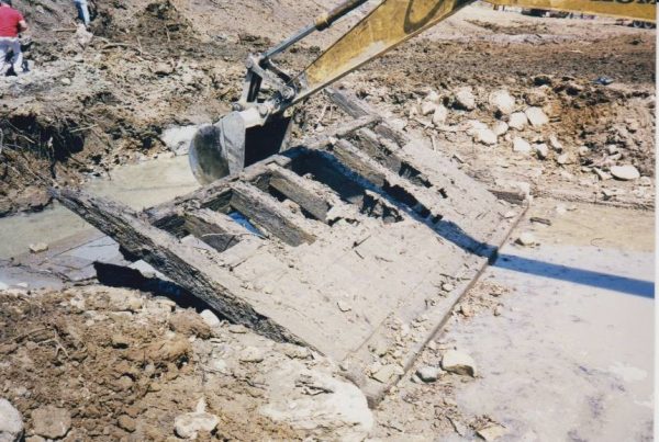
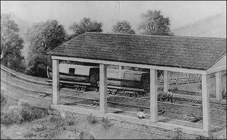
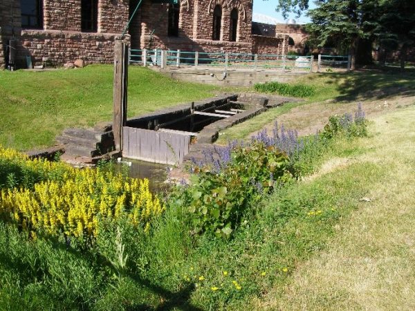
Some will surely ask what is a tumble and what is its function? The attached photo was taken of the lock at the mill site in Metamora. 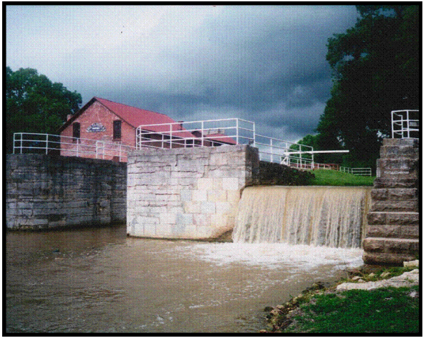 The tumble is the bypass where excess water flowing from the higher elevation can pass around the lock bottleneck when the lock’s normal operation does not completely utilize the water flow. This tumble retains the canal water in the canal without disruption or water loss. In some situations where there isn’t a lock, excess water can be removed from the canal channel and directed into an outside stream. This type of structure is called a weir. The best example of this type of structure was located 5 miles west of Fort Wayne on the Wabash & Erie Canal. It was called the Marais Du Perches (Sea of Fishes) and was located near the Towpath Trailhead along Engle Road. Here the seasonal water that flowed into the canal from a stream was allowed to exit the channel via a weir with several sliding gates that let the excess water flow back into what is today’s Eagle Marsh. Two examples of weirs from the C&O Canal that remain today give us a better idea of how the W&E weir functioned.
The word ”weir” may seem unfamiliar to you as it is derived from the Anglo-Saxon word wer. The Saxons, as well as other cultures, used this type of structure to direct fish from a river or stream into a narrow opening where a weir net could be used to easily harvest fish. It sure beat a hook, line and pole. Evidence of this type of fishing is visible as far back as 6000 years ago even in South America.
The necessity of water outlets or bypasses in a canal is quite obvious when we consider the hydraulics of water, as a liquid, it will always flow from a higher level to a lower elevation. If we dam a river and direct the water flow into a narrow channel and stop the flow every few miles with a lock, the water has to have some place to flow. The canal weir was usually a fixed structure that acted like the overflow drain in a bath tub. If the water reached the top it could flow into a nearby stream etc. Tumbles by themselves at the lock were not enough, so additional weirs at certain locations along the way were required so that the water level could be maintained in the channel or prism at a 4 feet depth, not overflowing the banks.
Even with tumbles and weirs the inflow of water into the canal at times during a freshet was so great that the banks were breached. Quickly erosion would send a torrent of water into the countryside.
Another type of safety outlet was a waste gate that could be dropped more quickly to allow excess water to flow from the canal. There were two of these type gates in Huntington County. This type of gate was patented by Robert English of Lagro IN. (The Hoosier Packet of June 1999). The one at Clear Creek was completely removed in 1999. Other waste weirs and gates were located at strategic points along the W&E Canal.
E.F. Lucas – Report To The General Assembly Of Indiana
December 1, 1845
“The greatest efforts that were made in the early part of the season, were to prevent the like occurrences that had happened to the canal the preceding year. Several large waste weirs were constructed for the purpose of draining the canal to the bottom on levels that invariably in times of high water, suffered damage to a greater or less extent; two of which are on Robt. English’s plan of patent gates – one of a large dimension at the mouth of Clear Creek, a short distance below Huntington. This creek empties into the canal rather as a feeder; but from some cause or other, the passway for the waste water in time of floods or heavy falls of rain, were not until the last season sufficiently provided for. The stream has its source in a very hilly country and at times floods the canal with more than the ordinary quantity of water, which heretofore invariably made heavy breaches in the embankment. There is one other on the same plan on the adjoining level below or west of Clear Creek.” (County Line)
“The gate can be used in making waste weirs to drain the canal to the bottom when it often occurs that outlets have to be made in the banks with considerable cost, and always attended with more or less danger.”
”The great secret in the management of a canal consists in that during floods, to keep the water out of it, and in low water keep it in.”
W&E History Highlighted At Covington
By Terry Bodine
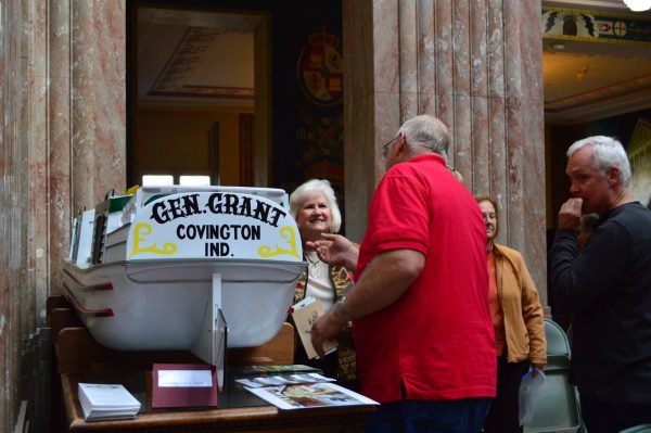
On October 23, 2016 the Fountain County Art Council, Inc. sponsored a reception at the Covington, Indiana Courthouse that highlighted the history of the Wabash & Erie Canal and it’s Covington connections. The model replica of the “General Grant, a line boat, was placed on display for the winter in the Courthouse
Opening ceremonies started with Canal Society member Guy “Finny” Filchak of Clinton, Indiana giving a brief history of the songs “On the Banks of the Wabash” and “Back Home Again in Indiana.” He then proceeded to sing both songs to those attending the event.
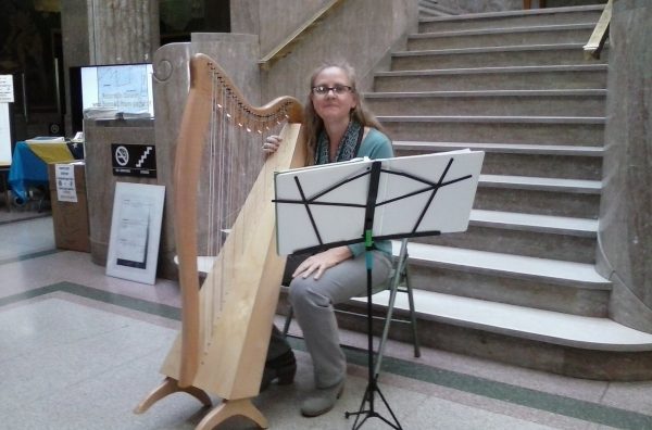
Musician, artist, poet, author, teacher and Canal Society member Liza Hyatt of Indianapolis shared the story of her Irish immigrant family, through harp music and words. They helped build many of the 468 miles of the Wabash & Erie Canal.
Nancy Wagner of the Art Council spoke about the “Put ‘em on the Map” project (a Bicentennial Legacy Project), which will get the historical Courthouse murals restored and preserved. Carol Freese (Canal Society and Art Council member) closed the program. Refreshments were served.
Questions & Answers
This new feature in The Tumble will be devoted to questions our readers submit and subjects on which they want more information. Email your questions to Indcanal@aol.com.
Sue Jesse- Fort Wayne IN
Q- I recently learned that in 1843 the Albert S. White was the first canal boat to travel the Wabash & Erie Canal from Lafayette to Toledo. Who was Albert S. White?
A- Albert Smith White, a practicing lawyer, was a U.S. Senator from Indiana from 1839-1845 who made his residence in Lafayette and also a home in nearby Stockwell, IN. At that time, Senators were chosen by the state legislature and it took 36 ballots for his election against his Whig rivals Governor Noah Noble and Thomas Blake. He, like fellow Whigs, was a supporter of internal improvements and also a booster of Lafayette development. He only served one term in the Senate, returned to private practice, then in 1847 became President of the Lafayette and Indianapolis Railroad. He served in this capacity until 1859 when he decided to run for Congress and served one term there from 1861-63. In 1864 he was appointed by President Lincoln to serve as U.S. District Judge for Indiana but he died shortly thereafter in that same year at age 61 and is buried in Greenbush Cemetery at Lafayette.
The Wabash & Erie Canal reached Lafayette in the fall of 1840 and water was let in allowing some boat traffic to reach 6 miles beyond the state line, east of Fort Wayne. In the spring of 1841 there were breaks in canal at the Birmingham bluff between Lafayette and Delphi. The Albert S. White was not the first boat on the canal but it was built in Lafayette by the Wabash & Erie Canal Transportation Company. In September 1841 she was sent to Fort Wayne for furnishings and final completion. The boat returned to Lafayette as the canal was not completed in western Ohio until late 1842. The Albert S White was only one of a series of boats that the canal company was using for regular packet service between Lafayette and Antwerp before the canal was opened to Toledo.
In May of 1843, the packet boat Albert S. White, was selected to honor Senator White and make the initial trip to Toledo where it arrived on May 8, 1843. The day of the event was a holiday in Toledo. The stores were closed, the flags were out, and everybody was waiting for the “Canal Boat.” About 2:00 P.M. citizens gathered at the landing near the junction of Summit St. and the Swan Creek Sidecut. They were not disappointed for soon the horse-drawn, flag-bedecked packet made its way from the nearby town of Maumee. When the boat came into sight there arose a mighty cheer from the crowd. As the boat docked, the Toledo band played patriotic songs. The captain, Cyrus Belden of Toledo, and crew were escorted to the Ohio House for the welcoming banquet. By 5:00 pm the crew returned, the signal gun fired and the boat was headed back to Indiana. Toledo citizens continued to celebrate, returning to the nearby Indiana Hotel for more drinks and eatables.
Phyllis Hess- Columbia City IN
Q- Someone recently told me that the Wabash & Erie Canal came into Whitley County. Is that true and where was it?
A- The Wabash & Erie Canal leaves Allen Co. just beneath and beside US Highway 24. At County Line Road the canal & highway enter Whitley Co. for about 6 tenths of a mile (1,056 feet) before reaching Indiana 114, which is the border between Huntington & Whitley Co. As the canal and road continue to the south they enter Huntington Co.
These counties are named as follows:
Allen: Col. John Allen led Kentucky militia but died at the Battle of River Raisin – 1813
Huntington: Samuel Huntington, signer of Declaration of Independence, Pres. US 1781
Whitley: Col. William Whitley died at Battle of The Thames 1813. He killed Tecumseh.
Thanks for your questions. We hope others will step forward with questions so that all readers will be able to learn more about canals. Email your questions to Indcanal@aol.com.
Canal Reservoir Collapses in Pennsylvania
By Bob Schmidt
This could have been the headline in the newspapers of Pittsburgh, Pennsylvania in June 1889. At that time it was the worst calamity in the nation’s history. On the afternoon of May 31, 1889 a total of 2,209 lives were lost as a 40-70 foot wall of debris and water roared into Johnstown, Pennsylvania. How did this old canal reservoir turn into a death trap for thousands of innocent victims? The old canal reservoir had changed hands and the dam modified by a gentlemen’s organization called the South Fork Hunting & Fishing Club.
Before we explore the details of this calamity, we need to understand why there was a canal reservoir at the foot of the Allegheny Mountains. In 1795 exports from the wharves of Philadelphia were 40% greater than at New York. In 1817 New York State embarked on an ambitious plan to build the Erie Canal. This canal was completed in October 1825 and soon shipping from New York exceeded that of Philadelphia. To make matters worse Ohio began building her canal system in 1825 to link Lake Erie with the Ohio River.
Pennsylvania needed canals, especially one to connect the state from Philadelphia to Pittsburgh at the headwaters of the Ohio River. The state began building a canal toward the east from Pittsburgh to Johnstown and toward the west from Philadelphia to Hollidaysburg, but in the middle they faced a major obstacle, the Allegheny Mountains, which rise over 1,398 feet from the two canal basins. A canal couldn’t be built over the mountains because of the lack of water at the summit and the sheer cost of the many locks required.
The Johnstown basin began operations in 1830 and drew its water from the Little Conemaugh River. The eastern canal at Hollidaysburg was operational by 1832. This left 36 miles to be connected by some sort of rail system. It was felt that the locomotives of the day could not generate enough steam power to negotiate the steep inclines required for an all rail route. Another plan was put forth using a combination of 11 sloping levels and 10 steam-powered lifts (inclined planes). This plan was accomplished by the Allegheny & Portage Railroad. The project was begun in May 1831 and completed by March 1834.
At either end of the railroad, canal boats were unloaded and their cargo put onto smaller rail cars that were pulled along the levels by mules, later by steam locomotives. Passengers boarded a specially designed car only used on this railroad. At the inclined planes the rail cars were hooked to a hemp rope 7” in circumference and by counterbalance and/or by stationary steam power pulled about ¼ to ½ mile up a 7-9% grade to the next level. In 1844 John A. Roebling’s wire-woven cable was used, replacing the rope, which frequently broke after about 16 months of exposure to the elements. There were double sets of tracks the entire distance and also a specially designed safety device to slow down any breakaway car. The whole passage of 36 miles could be done in about 6 hours. Later, segmented canal boats were tried that would fit directly onto a rail car to avoid the trans-loading of cargo. Unfortunately, being smaller, these were not very popular since they couldn’t carry as much freight.
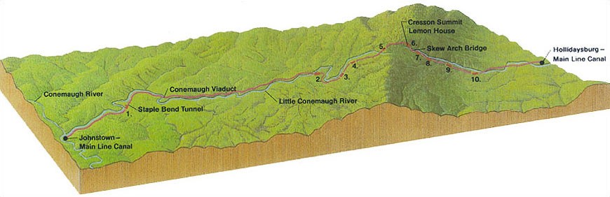
The completion of the Portage Railroad brought considerably more canal traffic at Johnstown and additional water was required from the Little Conemaugh River for canal and industrial uses. The town grew to about 30,000 by 1889. A canal reservoir (Lake Conemaugh) was completed on the South Fork of the Little Conemaugh River between
1840 & 1853. The dam was 850 feet long and 80 feet high with a spillway 61 feet wide at the floor, which was 10 feet below the crest of the dam. The 43.4 square mile watershed of the South Fork filled this reservoir for two miles. It was situated 450 feet in elevation above Johnstown, which was 14 miles away in the valley below. In the center of the dam was a culvert and nearby a valve house. Three cast iron pipes allowed water to be controlled and directed into the South Fork as required to supplement the higher volume and free flowing North Fork of the Little Conemaugh River. The two branches joined about two miles below the dam site at the town of South Fork. From this point another 12 miles downstream at Johnstown, the Little Conemaugh River combines with Stoneycreek River to form the Conemaugh River, which then flows westerly and eventually pours into the Allegheny River above Pittsburgh. Johnstown is built on the flood plain where the three rivers merge. It is similar to Fort Wayne and her three rivers except the town is situated in a narrow valley.
By 1857 the abandoned Portage Railroad and Main Line Canal were purchased by the Pennsylvania Railroad. They constructed their lines separately using only part of the old rail line. In 1862 a freshet washed out the center of the original dam and damaged the culvert. In 1879 the railroad sold the abandoned canal reservoir to South Fork Hunting & Fishing Club, a group of wealthy businessmen from Pittsburgh and elsewhere. In making repairs to the dam, the old culvert was sealed off with a stone wall and the hole in the dam was filled with dirt and old brick. The dam was only restored to a point 6 feet above the old spillway. This was 4 feet lower than it had been at the time of the canal. In front of the old spillway an iron grate was built so that fish would not be able to escape through the lake overflow. The level of the lake was also raised to produce a waterway of 3½ miles long by 1½ miles wide.
One of the club members was David J. Morrell, president of the Cambria Iron Works in Johnstown. He was so concerned about the dam repairs that he sent one of his company’s engineers to the site and offered to help pay for some construction changes to the dam. Despite this offer, the club refused to make the changes.
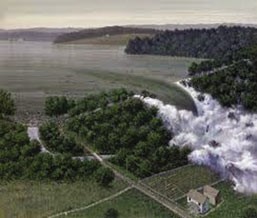
On May 31, 1889 after eleven days of rain, Johnstown began to have flood waters in its streets. Water from the South Fork poured into Lake Conemaugh. The fish grate over the spillway became clogged with vegetation. By 11:30 a.m. water was pouring 6 feet deep across the spillway and lapping at the top of the dam. Efforts to open the spillway and add height to the dam were too little too late. Messages were sent by telegram down the valley to Johnstown, but they were largely ignored as warnings had been issued many times before that the dam could fail. A few minutes after 3:00 p.m, the top of the dam was breached and the whole dam gave way in a roar. The water rushed down the valley picking up trees, homes, and debris. The town of South Fork was washed off the map. As the waters reached the Conemaugh viaduct, an 80 foot stone arch used by the railroad, the debris temporarily slowed the tidal wave, creating a 90 foot lake. However, after a few minutes the whole structure was blown apart and the destructive wall of yellow water and debris roared into Johnstown. When the deluge hit a stone bridge at the other end of
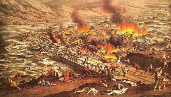
town, the structure held, but people, animals and debris piled up and soon those not killed by the flood died trapped in the fire that broke out on the oily water. Officially the death toll stopped at 2,209, but it really is unknown. Clara Barton and the newly organized (1881) American Red Cross came to town to assist in the relief. There was an investigation to assign responsibility. No one was prosecuted and the dam and lake were never rebuilt.
Today you can visit the site of the dam and the Johnstown Flood
National Memorial, operated by the National Park Service. Also in Johnstown is the Flood Museum at 304 Washington Street and victims of the flood are buried in Grandview Cemetery. CSI members visited these sites on Saturday October 7-9 as part of the joint Ohio/Pennsylvania Canal Society Tour. Total attendance was 56.
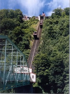
Johnstown also has the steepest incline in the world (35 degrees) that holds 60 passengers or freight and carries them 530 feet up the side of a high mountain ridge. Due to our time limitation we choose to go to the 9/11 site of Flight 93 near Shanksville, Pennsylvania instead of waiting for the incline to open.
In Remembrance
By Tom Castaldi

Tim Doyle, 70, of New Haven, Indiana passed away on Sunday, November 6, 2016. Tim was a noted stone carver whose works graced buildings from Fort Wayne to West Point. Craig Leonard, his friend and historian, said, “A truly great artist has been among us.”
Tim was one of seven master stone carvers in the United States. He created a seal for the gateway at the U.S. Military Academy at West Point, a large Christ in Charleston, South Carolina, and a large seal for the city of New Haven. Other instances of his works can be found in Marion and Hamilton counties in Indiana. In 2009, he recreated an eagle head on the Allen County Courthouse in Fort Wayne. Another major accomplishment occurred in 1993 when he took six tons of Indiana limestone and turned it into an image of St. John Newmann for Fort Wayne’s Catholic Cemetery.
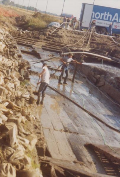
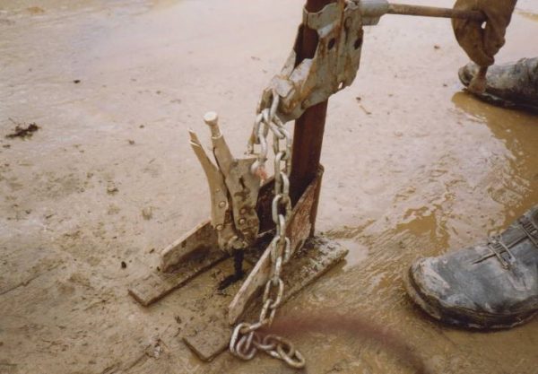
For canawlers he is best known for the extraction and preservation of the Gronauer Lock of the Wabash & Erie Canal unearthed in New Haven in 1991-92. He used his creative abilities to extract the timbers from the site. Once the timbers were uncovered they had to be kept wet to keep them from deteriorating. Tim designed an elaborate drip watering and spray system. He also came up with a way to pull the long nails/spikes out of the lock flooring using a vice-grip, car jack, and chain, pictured below. He spent hours in the wet muck in and around the lock until the timbers were removed, placed on a truck, and transported to Columbia, South Carolina for treatment with Polyethylene-Glycol at the University of South Carolina.
When plans were being made to extract the lock Doyle said, “ We have to be inspired to use our hands, as well as our minds. You can not have separate workers and thinkers. We must have working thinkers. Otherwise we will not get goods of quality in the future.” At the time he was a member of the New Haven city council and in 2003 he unsuccessfully ran for mayor of New Haven against current incumbent Terry McDonald.
After a hospitalization period of about a month, lung cancer took Tim’s life. He left behind his wonderful stone carvings that serve as his monument.
Photos courtesy of Pat Derrow and Bob Schmidt
Visit To The Indiana Theatre At Terre Haute, Indiana
By Sue Simerman
While at Terre Haute’s library on October 22, 2016, for our CSI board meeting, we walked two blocks north to 683 Ohio Street to visit this old theatre from the 1920’s. While in Ohio (October 2015) with the joint tour of the Canal Society of Indiana and the Canal Society of Ohio we were guided through the Midland Theatre in Newark, Ohio. That theatre had extreme water damage and a great deal of the building was “new.” Newark’s theatre inspired the visit to this beautiful theatre near the path of the Wabash & Erie Canal in Terre Haute.
Its first owner was T. W. Barhydt, who wanted to do something to show that Terre Haute was more than a “one horse town.” The architect was John Eberson, who gained much fame later. He designed this theatre with the idea of bringing the outdoors inside with motifs, colors and lighting. Construction began in 1921. Much was created on site and immediately put into place. Thus the theatre was built in a relatively short amount of time. At its opening date on January 28, 1922, a silent film was shown along with a performance by the Indiana Symphonica Orchestra. In the 1920s Vaudeville acts were performed as well as the showing of silent films. The theatre experience was more than just being at a show.
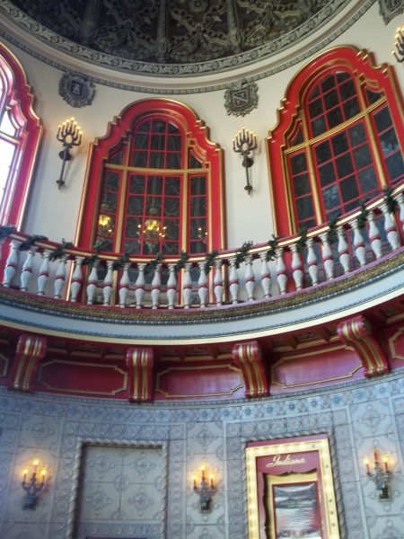
When we entered the front doors we were entering “Daybreak,” which, with color, lighting, and a rotunda dome, showed early morning. The rotunda entry has pastel colors that shift to the reds and golds of a sunrise. The many clay tiles used have a Spanish influence. I had to admire the workmanship of them because of their curvature plus we were told all were made on site.
We were introduced to the owner, Mr. Rob Lunstrum, who has owned the theatre for 3 and a half years. He kindly showed us around. We could tell that he has a deep love for this special theatre. He has done much to update the building. It is now an event center and can be rented for many occasions.
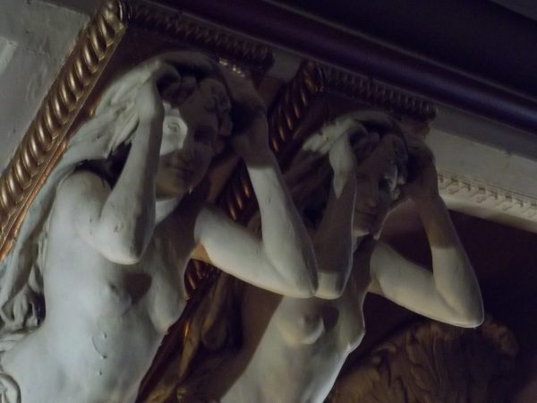
Upon leaving the front entry, we went through more doors into the promenade of the lobby which represents “Daytime.” The ceiling is very decorative and the sight of female and male statues looking down on us was very surprising. This was Moroccan and the statues have inspiration from southern Italy.
Then going through the third set of doors we entered night, called “Mystic Mystery of Nightfall.” The auditorium is still much as a movie theatre with a stage and side balconies, which look usable but are just for show. Some of the 300 seats have been removed. The created flat area had tables and chairs set up for a wedding reception that would be occurring in the evening. We entered this dining area in the middle of the auditorium. He called this “The Terrace” and theatre seating was above and below this level. We were told they now use a digital projector for HD, DVD, and Blu-Ray. They are waiting for an organ to be delivered after having been refurbished. Total capacity, which includes portable seating, is 1,562.
Walking on the stage, we could see that some of the original floor is still in place and were told it is 88 feet from wing to wing. We could see the backstage gearing and the screen that is 54 feet for showing occasional movies and presentations. We also were taken down below to see an original dressing room with flaking paint and several areas including the furnace room.
The building is on the National Register of Historic Places. Some of the notable performers who have been to the theatre were Frank Sinatra and Red Skeleton.
Hubert Hawkins Award
By Rachel Hill Ponko, Indiana Historical Society
Some have the gift of music to share with the world. Others have the artistic touch. Fort Wayne’s Carolyn I. Schmidt has knowledge—the history of Indiana’s canals. It is due, in part, to her dedication to the cause of transportation history that the Indiana Historical Society is proud to present her with its 2016 Hubert Hawkins History Award.
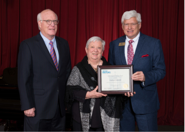
Photo courtesy Indiana Historical Society
Each year, IHS presents the Hubert Hawkins History Award to an Indiana historian for distinguished service during his/her career in local history. Schmidt received her award during the annual Founders Day event on Monday, Dec. 5, at the Eugene and Marilyn Glick Indiana History Center.
For the past 15 years, Schmidt has served as editor of the Canal Society of Indiana’s monthly publication, The Hoosier Packet. Many are quick to point out it is a “herculean” task and one she took on as a volunteer.
“As an excellent reporter, editor, and researcher, she garners good, meaningful stories of canal era leaders and their work,” writes Wabash & Erie Canal Association President Dan McCain in a letter of support. “She secures many other stories from a myriad of Canal Society members and others that fill the monthly newsletter with interesting pages.”
Carolyn is recognized as a hub of information on Indiana’s canals. She has provided background research for archaeologists excavating Indiana’s canal sites, developed guidebooks and organized local and regional canal tours. In addition, Schmidt often speaks to schools and civic groups.
Although Carolyn has produced our recognized historical publication for 15 years, before that she was the Editor of our society newsletter as well as most of our tour books. We congratulate her for her fine work and contributions to CSI over these many years. The Hoosier Packet is now available at many libraries throughout the state. The Allen County Public Library and the State Library have bound back issues. Carolyn will continue to support Ball State in their role as publishers of The Tumble by review of materials submitted to CSI.
Visiting Old Locks at Sault Ste. Maria
By Ed & Cynthia Powers
The first canal at Sault Ste. Maria, along the St Mary’s river connecting Lake Huron and Lake Superior, was built on the Canadian side of the river in 1798, by the North West Company (Hudson Bay Fur
Company). The lock was thirty eight feet long, nine feet eight inches wide, and had a lift of nine feet. The bateaux of the trappers were dragged through it by means of an ox team walking along a towpath. Although this his lock was destroyed by United States troops in 1814, the floor timbers and sills remain. The lock was restored some years ago and forms one of the attractions of the Canadian Soo. The next locks were constructed on the American side of the river (1853 to 1855) by the state of Michigan. Later a Canadian lock was completed in 1895.
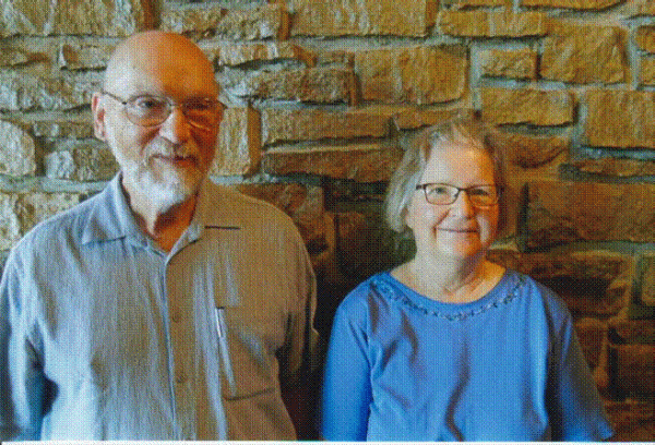
We saw this restored canal lock in Sault Ste. Marie, Ontario in July 2016. This was the 10th Road Scholar (Elderhostel) trip that we attended. We’ve found all of them well planned and a good buy, as most meals are included. The majority of participants are retired teachers or others who have broad interests in history and nature. While there, we got to enjoy the Canada Day festivities on July 1st, and then on July 4 our U.S. holiday on Mackinac Island.
Near the old canal and the river that separates the Canadian side from Sault Ste. Marie, Michigan, we went on an evening nature walk where we saw several beavers swimming through water lilies and duckweed; and black-crowned night-herons fishing near the power plant.
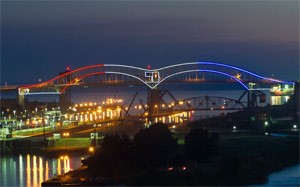
During this walk we could see the red, white and blue lights on the US side of the International Bridge, and red and white lights on the Canadian side. Other parts of our tour in Canada were visits to an art exhibit and to a very unusual museum for bush “pontoon” planes.
Elderhostel runs tours all over the world, and many in the US. Some of our CSI members will be attending one of these tours in Panama in March.
www.roadscholar.org – Grit & Glory Panama Program # 9901 Mar 4 -9 2017