

Index:
Canal Demands Remove Miami Indians
By Bob Schmidt
Looking back nostalgically at the Wabash & Erie Canal, we tend to gloss over the fact that the banks of the Wabash River were once the homeland of Native American Indians, the Miami. Perhaps it was inevitable that the Indians were forced to move, because, from the time of the earliest English colonial settlement, the native peoples had to yield to the onslaught of European civilization. English common law demanded that any land be “fairly” acquired through legal purchase versus confiscation. A pattern of Indian treaties, purchase agreements and annuity payments was established early in our history. Although North American Natives were supported by both French and English, the end result was always to take their undeveloped woodlands and turn the rich soil into individual farms.
Indians in general were mobile. With plenty of land they moved on as hunting declined or the land was depleted. Miami culture was also based on hunting, gathering and sometimes small scale farming. Men hunted game and women raised white corn, beans and squash. Women also gathered berries and fruit. The Miami lived in log structures and had a large village called Kekionga (blackberry bush or blackberry patch) at the junction of the three rivers in Fort Wayne. Efforts to change them to the European style of farming and lifestyle were unsuccessful.
After the American Revolution, Congress in 1787, under the Articles of Confederation, established the Northwest Territory, totally ignoring the fact that the territory was on occupied Indian lands. The assumption was that it was just a matter of time before the Indians could be amalgamated or pushed further west beyond the Mississippi. They were seen as an obstacle to westward expansion. A series of Indian wars took place to subdue them. In our area it culminated in 1794 at the Battle of Fallen Timbers near Toledo, Ohio. This was followed by the Treaty of Greenville in 1795, which carved out land in Indiana for settlement.
William Henry Harrison arrived at Vincennes as the governor of the newly established Indiana Territory in 1801. His mission was to prepare Indiana for statehood by treaty negations and Indian removal. He also engaged the Indians in battles. In the 1811 Battle of Tippecanoe he defeated the Indian village at Prophetstown near Lafayette. In the 1813 Battle of the Thames he defeated Tecumseh and that ended all Indian military opposition. Through a series of treaties and purchases only the area of northern Indiana remained in Indian hands by the 1820s.
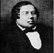
Governor William Henry Harrison’s treaty with the Indians

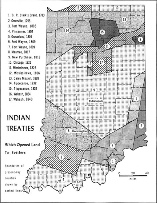
In 1816 Indiana became the 19th state of the American Union. Internal improvements were being constructed throughout the nation to transport its productive output and to develop state economies. By the 1820s Hoosiers wanted canals as well as better roads. In 1824 the Federal government offered them a narrow strip of land stretching from the Maumee River to the Wabash River that did not involve any Indian land. This grant was rejected. Any extension of a canal along the Wabash River involved acquiring Indian lands.
In October 1826 several weeks of negotiations for a treaty with the Miami and Pottawatomi was conducted at Paradise Spring in Wabash, Indiana, by James B. Ray, Indiana’s governor; Lewis Cass, the governor of Michigan Territory; and John Tipton, the Indian agent. Their objective was to obtain land along the Wabash River for a canal and land in central Indiana to build the Michigan Road from Indianapolis to the Michigan line. With very limited options the Indians agreed to surrender land in exchange for goods, gold and annuity payments. This fragmented and reduced the size of Indian lands making hunting more difficult as white settlers quickly moved in as soon as land sales began. Later, the 1830 Federal Indian Removal Act would firmly establish the government’s intention to remove all Indians from land east of the Mississippi over time.
On February 9, 1827 there was a debate in Congress over a bill to provide for adjustment of claims under the first article of the Treaty of Ghent. The bill was to appropriate six sections of land for the purpose of aiding the State of Indiana in opening a Canal to connect the water of the Wabash River with Lake Erie. During the debate Mr. McKinley reported that “The Indian title was decided to be only the right of occupation. The Indians were by no one considered as independent nations.”
On March 2, 1827 the Federal Congress gave Indiana a land grant of alternate sections of land five miles on either side of a canal route from the Tippecanoe River to the Auglaize River at Defiance, Ohio. This land grant amounted to 527,571 acres in Indiana and Ohio. Some of this land near Wabash and Peru, Indiana, was still owned by the Miami Indians, so that it could not be sold to fund the canal. To remedy the loss of this revenue, Indiana requested compensation from the government and asked for additional lands outside the grant route that they could sell. David Hillis, Jordan Vigus and Jesse Williams had selected the canal route and therefore the sections to be given to the state. Based on their recommendations a 3-tier valuation system for various sections in the grant was determined. About 19.3 miles along the canal route from Wabash to Peru amounted to 61,741.11 acres and were valued at $230,198.50 as follows:
Types of Land and Determined Value
| 1st Tier 1,747.24 acres $7 = $ 12,230.68 The best land
2nd Tier 18,993.37 $5 = $ 94,966.35 Marginal for crops 3rd Tier 41,000.49 $3 = $123,001.47 Swamps, lowlands Total 61,741.11 acres $230,198.50 Avg $3.73 Sold 23,705.66 – Nov 1840 $ 97,856.88 Avg $4.13 Unsold 38,035.45 $142,340.18 Avg $3.76 1 section = 640 acres / 5 sections in 10 to State = 3200 acres per mile |
Another 24,290 acres valued at $202,458 ($8.34 acre) were within the land grant and had been given to specific Indian chiefs and the Miami nation. Much of the Miami lands were located close to the canal route and thus more valuable than lands outside of the land grant of 10 miles. Indiana requested Congress to allocate 69,883 acres outside of the grant to compensate for these “lost” acres. (The land actually sold equaled $4.13 per acre, while the Indian land was claimed by Indiana to be worth $8.34 per acre.) One specific example of this type of land was at Lagro. There the north side of the canal was so close to the river that there was little room for a mill. There was room for a mill on the south side of the canal but that land was owned by the Indians. Hoosiers, thinking only of their interests, hoped the Indians’ land rights would soon be extinguished. Congress refused to do the latter. Therefore Congress gave Indiana additional acres as requested. These acres were valued at $202,458 (more acres but at lower value). Remember, the goal of the land grant was to provide funding for a canal not to provide land for the route of the canal.
In 1838 the Pottawatomi were removed from Indiana. This removal is known as “The Trail of Death” when about forty-two Indians died. That same year six Miami chiefs were sent west to Kansas to evaluate the suitability of land there for their members. They found the land to be unsatisfactory.
The Miami chief, Jean Baptiste Richardville, who had moved the tribal council house to the Forks of the Wabash in 1831 but continued to live along the west side of the St Marys River in Fort Wayne, was able to stall off Indian removal. He was supported by the local traders, who benefitted by selling their wares when the Indians received their annual annuity payments. However, Richardville died in August 1841 and the new chief, Francis La Fontaine, was not as effective in representing the Indian position.

On May 19, 1845, Asa Johnson, the Presbyterian minister at Peru, Indiana, wrote to Milton Badger, “Peru must be a very wicked place till these Indians are removed. This I suppose will take place in about a year.” The Indian reservation was settling fast, mainly by squatters who moved in before the land was surveyed.
In March 1846 the entire Miami annuity payment of $12,500 was turned over to the Ewing traders as a final debt settlement. President James K. Polk also was pushing Indian removal. Chief La Fontaine went to Washington to talk with him but was unsuccessful in delaying Miami removal. The chiefs, their relatives, and those of Frances Slocum were to be exempted from the removal. Also Indians who owned private property were allowed to remain in Indiana.

In September 1846 the Bureau of Indian Affairs announced that there would be no more annuity payments until the Miami moved west. A small military force of sixty-four men arrived in Peru on September 22. The Indians were told to be there by October 1st, but none of them appeared. On October 6, 1846 the troops rounded up about 350 Miami, put them onto three canal boats, and took them from their homeland. Two more boatloads of Miami were picked up in Fort Wayne. The five boats proceeded to Junction, Ohio where they turned south and proceeded down the Miami & Erie Canal to Dayton and then Cincinnati. (The Miami & Erie Canal had been opened to Junction in 1845. Without the canal the Miami would have been moved west by wagon and walking just like the Pottawatomi in 1838.) Chief La Fontaine went to Kansas with the tribe.

On May 10, 1847 Asa Johnson wrote to Charles Hall, the executive secretary of the American Home Missionary Society, “The Miami Indians have been removed to some place on the headwaters of the Missouri. They went very reluctantly. U. S. troops forced them to go. About 30 of them died on the journey. Several have died since. They are greatly dissatisfied with their new home. They are determined not to stay there. About 40 of them returned to this vicinity about four weeks ago. La Fontaine, a principal chief, died on his way back. He was half French, Roman Catholic and very sick. The Indian was a great drunkard. He had been dissipating most of the winter. The way of transgressors is hard.” The minister believed that the wealth of La Fontaine had been left to the Roman Catholic Church.
Chief Francis La Fontaine did die of illness near Lafayette on his return trip to Indiana in 1847. He is buried in Mount Calvary Cemetery in Huntington.
At Cincinnati, the Miami were transported by the steamboat “Colorado” down the Ohio River and up the Mississippi to St Louis, arriving on October 29th. Here they were transferred to the steamboat “Claremont II” and taken up the Missouri River to Kansas Landing (Kansas City) and then by wagon 50 miles to their reservation within the future Kansas Territory (1854). They numbered about 323 members. About 60 of these Indians eventually returned to Indiana.
On December 20, 1847 Asa Johnson wrote to Henry Little that he had been released from the Presbyterian church at Peru, Indiana and had been working in the “great Miami Reserve. It is a new field about thirty miles square. A few years ago that tract of land belonged to the Miami Indians and when I came to Peru ten years ago not a white family was living upon it. Since that time it has all been purchased of the Indians at about $2 per acre. The Indians have been removed beyond the Mississippi. A part of that land has already been brought in market and the rest of it is to be next May.”
The Miami Reservation in Kansas came under tumultuous times in bloody Kansas as John Brown, who settled nearby, murdered proslavery settlers at Pottawatomi Creek in 1856. A planned railroad west was routed through their reservation bringing more settlers. The Bureau of Indian Affairs disbanded the reservation system in favor of private land ownership. In 1873 the remaining Indian lands of the reservation were sold and the western Miami (about 60-70) under the leadership of Thomas Richardville, grandson of Jean Baptiste Richardville, moved to Indian Territory (Oklahoma) near the town of Miami, which they established as their headquarters in 1891. Some Miami remained on private owned land in Kansas. Some had moved on to other locations.
(Apr. 23, 1830- Jan.16, 1911)
Thus the Miami nation was divided into 2 groups, the Eastern Miami in Indiana and the Western Miami in Oklahoma. The Eastern Miami received federal recognition as a tribal group in a treaty made on June 5, 1854; however, its federal recognition was terminated in 1897. The federal government only recognizes the Western group since they had officially moved west. The controversy remains today as the Eastern Miami at Peru are still struggling to gain recognition from the federal government.
The part the Wabash & Erie and Miami & Erie Canals played in the division of this Indian nation is truly a sad result of westward expansion. Journals of the Indiana Senate and General Assembly, letters between ministers, and court cases show that the Indians were seen as a nuisance or an obstacle and were not given much consideration when Internal Improvement plans were made.
Bibliography
Ancestry.com
Francis La Fontaine
Jean Baptiste Richardville
Thomas F. Richardville
Annual Report of the Board of Internal Improvement of the State of Indiana. Indianapolis, IN: Douglas & Noel, Printers, 1840.
Anson, Bert. The Miami Indians. Oklahoma: University of Oklahoma Press, 2000.
Billings, W. E. Tales of the Old Days: North Manchester and Wabash County. North Manchester, IN: The News-Journal, 1926.
Fatout, Paul. Indiana Canals. W. Lafayette, IN: Purdue University Press. 1972.
Find A Grave – Chief Thomas F. Richardville FG # 61443123 Miami Oklahoma
General Public Acts of Congress Respecting the Sale and Disposition of the Public Lands. Washington, D.C.: Gales and Seaton, Printers, 1838.
Journal of the House of Representatives of the State of Indiana –20th Session. Indianapolis, IN: Douglass & Noel, Printers, 1836.
Journal of the House of Representative at the 25th session of the General Assembly of Indiana. Indianapolis, IN: Osborn & Chamberlain, Printers, 1840.
Journal of the Indiana Senate – 16th Session 1831. Indianapolis, IN: A. F Morrison,1831.
Laws of the State of Indiana, Passed and Published at the 17th Session of the General Assembly. Indianapolis, IN: Douglass and Maguire, 1833.
Raffert, Steward. The Miami Indians of Indiana. Indianapolis, IN: Indiana Historical Press, 1996.
Register of Debates in Congress of the 2nd Session of the 19th Congress. Washington, D.C.: Gales and Seaton, Publishers and Printers, 1829.
Rudolph, L.C., Wimberly and Clayton. Indiana Letters: Abstracts of Letters from Missionaries on the Indiana Frontier to the American Home Missionary Society 1824-1893. Found on the internet.
John Murray Lockwood
Find-a-Grave: 35672253
By Carolyn Schmidt
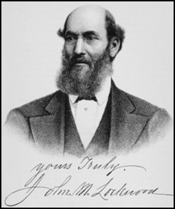 John Murray Lockwood is of English-Quaker descent. He is a descendant of Edmund Lockwood, who came with Governor Winthrop and his Pilgrim band in 1630. His father, Isaac Lockwood, settled in Westchester Co., New York about twelve miles north of White Plains, and for many years carried on his trade as a hatter. Isaac married Phebe Walters and they had seven children between 1805 and 1815: Stephen Underhill, John Murray, Isaac, Edward Burr, Emma, and twins Phebe and Anthony Walters Lockwood. Our subject, John Murray Lockwood, was born in North Castle, Westchester County, New York on April 24, 1809. Educational opportunities for country children at that time were very limited.
In 1818 Isaac Lockwood moved his family West. They arrived in Evansville, Indiana that June when John was 9 years old. Isaac went North and entered one hundred and sixty acres of land in the vicinity of Princeton, in Gibson County, Indiana. Unfortunately for John, his mother, Phebe, died at Princeton in 1819 and she was followed in death by John’s father, Isaac, who died at Princeton in 1820. John was now orphaned before his twelfth birthday.
 John Murray Lockwood was in a desolate state of mind. He became a “bound boy” until he was of age to James Evans (a brother of General Robert M. Evans after whom Evansville was named). John went to Evans’ home. Mr. Evans was a justice of the peace, a small farmer, and the owner of a set of carding machines. Luckily, Mr. Evans was a kind and faithful master, gave John all the advantages of a member of the family, and John had a happy life. He received a fair education and a thorough knowledge of farm life. He spent much of his early life at work on the carding machines, and kept books for his employer. At age fifteen he took full charge of the machines. He even carded a sack of wool brought to him by the rough backwoods boy, Abraham Lincoln, later in 1829. He was a personal friend of Lincoln throughout his lifetime.
At age twenty-one Mr. Evans gave John one hundred dollars, and a suit of clothes much better than his ordinary apparel. He also began receiving one-sixth of the income from the carding machines and by the following fall had saved a considerable sum. Using these savings and the $100 he had been given, he and Dr. Neely purchased a flat-boat, loaded it with corn, and headed for New Orleans, going down the Patoka, Wabash, Ohio and the Mississippi rivers. At Bayou Sara they disposed of the corn. While there John had an attack of yellow fever and couldn’t return to Princeton for two weeks. When finally got back to Princeton in July 1831 and that September he moved to Evansville and opened a grocery store on the northeast corner of First and Main streets with a capital of $250.
John later described Evansville and its inhabitants in 1831 as follows: “In 1831 I located there (in Evansville), boarding with Robert M. Evans — price of board per week $1.25. His residence was on his farm over the canal outside of the corporation, on the state road. From the Ohio river to Evans’ farm up Main street there were five buildings on the west side and seven on the east side, and some other streets were built in about the same proportion. I found the town small and dull; plenty of vacant lots …any number could be had for $20 or $25; dog-fennel and stumps in every direction.”
John purchased eight hundred dollars worth of groceries from the Lewis Brothers, and, as a merchant, experienced troubles and worries with the credit system. He worked hard, gradually established a trade, and paid his accounts as they came due. In 1834 he added a stock of dry goods, lived above his store, and made his business even more successful, which was noticed by the movers and shakers in Evansville at that time. He was also known to them due to his living with both James Evans and General Robert M. Evans.
Politically John was a Republican, but he was not radical in his views. In 1833 he served as a trustee of Vanderburgh County and as its treasurer 1833-1836. In 1834 he became its president. In 1833-34 he served on the Evansville city council. He later was instrumental in securing the right-of-way, voting for the tax in Prairie Township, Vanderburgh County, for the Evansville & Crawfordsville Railroad.
On April 24, 1834 John Murray Lockwood was united in marriage to Caroline Charlotte Newman. She was the daughter of James Newman, who settled in Evansville in 1819.
Also in 1834 he was largely instrumental in organizing a branch of the State Bank of Indiana in company with Charles I. Battel, Horace Dunham, John Mitchel, James Lewis, and Robert Stockwell, of Princeton.
In 1836 John was among the managers of the famous “Canal Dinner” held in Evansville. Luckily John had saved an old invitation to that dinner and was able to pass it on to A.H. Sanders, the editor of the Evansville Daily Journal. In the following editorial of June 1853, Sanders laments on the failure to hold any celebration at all, even though the great works were completed. The editorial also relates what happened at the earlier dinner complete with toasts of joy as follows:
~~~~~~~~~~~~
“June 11, 1853 Saturday Morning
“Evansville Daily Journal
“CANAL CELEBRATION—OLD TIMES
“A.H. Sanders, Editor
“We guess, if the forefathers of Evansville, when they had their great Canal celebration in 1836, over seventeen years ago—a celebration intended to commemorate the commencement of this magnificent enterprise in connection with other improvements — had been told that their children would not celebrate its completion, they might have given the lie to the asserter of so seemingly slanderous a statement. Yet even so does it seem, that we are to have no celebration of this great event. On the completion of a railroad, which was probably only the enterprise of a couple years, towns interested generally mark their joy by public meetings, a commingling of feeling, and a rich treat of congratulations and victuals. But when we are about to see the last shovelful of earth thrown from the mightiest public improvement in the west, if not in the whole country, and which has been nearly a quarter of a century in the thoughts of the people and building—a canal connecting the Lakes at the north with the Ohio river at the south—no one but a poor devil of an editor raises his voice for a celebration and he is left alone to set the ball in motion.
“Probably in the next half century to come, no event will transpire so important to the interest of Evansville, as the final completion of the great Wabash & Erie Canal, having its lower terminus at this point.— We do not desire a celebration as a mere exhibition of joy, on the other part of our fellow citizens, but to let the world known in a loud manner, that this magnificent enterprise is completed, and to let it know too, how great is the works importance to this city. It will help turn the eyes of the public to Evansville where it terminates. The eyes to thousands will turn here, that never regarded us with a special interest before. — The effect will undoubtedly be highly beneficial to us, and that’s enough.
“There are a few old citizens among us who recollect the great celebration at Evansville in 1836. It will be pleasant memories revived to have some matters connected there-with brought up again, and at the same time exhibit to new citizens some of the enthusiastic spirit which marked old times in Evansville. Let us see. Here is a copy of the printed invitation, sent to persons all over the State. The copy in our possession, and probably the only one extant, is addressed as follows:
~~~~~~~~~~~~
“Evansville March 22, 1836.
“CAPT. JAS. NEWMAN —Sir: The citizens of Evansville, impressed with a belief that the act passed at the last session of the Legislature, “to provide for a General System of Internal Improvements”—is one that will promote the wealth and prosperity of the people of Indiana and redound to the honor and glory of the State: and wishing publicity to manifest their high regard for the service rendered to the State at the large, as well as to their own town, by the acts of Executive and Legislative departments of State, in regard to Internal Improvements, have resolved on giving to his Excellency the Governor, his Honor the Lieutenant Governor, and all of the members of the General Assembly, who supported the Internal Improvement bill, a Public Dinner, on the 4th day of May next.
“Believing that you, sir, entertain the same enlightened and liberal views, that have characterized the proceedings of the Executive and Legislative councils of the State during the past session of the General Assembly, we, in behalf of the citizens of Evansville, respectfully invite you to join with us in paying a tribute of respect to exalted merit.
SILAS STEPHENS,
IRA FRENCH,
JOHN SHANKLIN,
JAMES LOCKHART,
JOHN M. LOCKWOOD,
F.E. GOODSELL,
V.K. PHAR
Committee
“Capt. Newman lives no longer. Silas Stephens, John Shanklin, and James Lockhart, are living in this city, and all enjoying prosperity and health. Ira French lives in Cincinnati, and is an enterprising citizen there as he was here. John M. Lockwood, to whom we are indebted for the above circular, lives within a few miles of this city. F. E. Goodsell resides at Bowling Green, Ky. V. K. Phar, is living at Boonville, in this neighborhood. So much for those directly connected with this circular.
“Of our old citizens who were active in getting up this celebration, which was called the Canal Celebration, although the circular does not allude to that particular improvement we may mention the following persons in addition, as those only now alive and known by our citizens: Madison F. Bray, Alanson Warner, Horace Dunham, John S. Hopkins, James G. Jones, John M. Stinson, John Mitchell, Robert Barnes, John B. Mansell, W. Brown Butler, Samuel Hall, John Douglas, A. B. Carpenter, A. J. Ellis.
“On the 4th of May, the celebration came off. A large crowd was present, among whom were a number of distinguished guests at 12 o’clock a pennant forty feet in length, with “Internal Improvements” inscribed thereon, was raised, mid loud shouts and the firing of cannon. The procession was formed at Maj. Warner’s Hotel, under the direction of W. Brown Butler, Chief Marshal, assisted by George Lyon. The procession moved to the grounds selected, where an elegant dinner was prepared by Edward Hopkins, father of the present mayor of Evansville, and now deceased. Maj. Clark, President of the meeting, made the opening speech before the reading of toasts. His speech is published in the Evansville Journal of May 12, 1836. After this came the toasts. Thus reads one:
“The Evansville and Vincennes Railroad! — Demagogues may prate, fools may scoff, and honest men may doubt; but time and perseverance will put them all to rights.
“We are pleased to announce that this road will be completed next fall! Time certainly has had a good deal to do with this enterprise, but time and remarkable perseverance will carry it through.
‘Here is another toast:
“Evansville. —With one foot on Lake Erie and the other on the Ohio, with her 400 miles of canals she is destined ere long to become one of the greatest commercial emporiums of the West. So is she becoming, if she may not be already called thus.
“At that time the completion of the Canal and Railroad was looked upon as a speedy triumph.
“In reply to the toasts— “Our Lieutenant Governor,” — Gov. David Wallace made an excellent speech.
“Gen. Milton Stapp also made a speech in reply to a toast complimenting him as an ‘enlightened and liberal statesman and a faithful representative to the great interests of his constituents.’ Gen. Evans, who was present, was highly complimented in both speeches. Col. Tos.
J. Evans made a speech being toasted as the chairman of the committee on Internal Improvements. Elisha M. Huntington also made a speech. Jos. R. Craig was toasted as ‘a faithful representative of the great interests of the South of White River,’ to which he replied.
“A large number of letters were read and volunteer toasts were offered. Some by persons whose names are given above. The editor of the Journal particularly alludes to the effect this celebration of 1836 must have in drawing attention to the ‘town of Evansville.’
“In the evening a grand ball was given, “at which there was assembled an array of youth and beauty seldom surpassed”. They danced all night according to the old fashioned way.
“This was one of the celebrations during the early days of Evansville. Yet now, when we are a flourishing city, it appears impossible to get up a celebration in commemoration of the greatest event in the history of Evansville.”
~~~~~~~~~~~~
It seems that nearly all the leading men of Southern Indiana attended the Canal Dinner. Along with the prestige of the new State bank, it gave Evansville some note.
In 1836 John and Caroline Lockwood moved to a farm about three and a half miles from Evansville. He could not reside in town due to his health; but until 1853, part of the time he lived in the country, and the remainder in Evansville. Although he wished to remain in Evansville, in 1853 his health forced him to move to Mt. Vernon. There he aided in founding the First National Bank of Mount Vernon. He served as its president for sixteen years, but he served in this capacity without compensation other than from the dividends upon his stockholdings, which were very considerable.
He had interests in many private and public enterprises. He was among the members of the canal boat stock company while being a banker. Others were John Hewson, Nathan Rowley, Robert Barnes, Stephen Hopkins, John Mitchell, John Douglas, A.B. Carpenter, Thomas Scantlin, and Marcus Sherwood.
He contributed freely to the cause of Christianity in both Evansville and Mount Vernon. He was well and favorably known in Mt. Vernon and Posey County as one of the wealthiest but most generous citizens. He was known for his character and business honor.
Caroline Charlotte (Newman) Lockwood, John’s wife, passed away at Mt. Vernon, Posey County, Indiana on November 2, 1886 at age 68. She is buried in Section OP Row 68 Grave 5 in Bellefontaine Cemetery.
John Murray Lockwood passed away on April 30, 1902 at Mt. Vernon, Posey County, Indiana at age 93. He was laid to rest in Bellefontaine Cemetery.
Sources:
Ancestry.com: John M. Lockwood family member trees.
Elliott, Joseph Peter. A History of Evansville & Vanderburgh County, Indiana. 1897.
Find-A-Grave: John M. Lockwood # 35672253
Gilbert, Frank M. History of the City of Evansville & Vanderburgh County, Indiana. Chicago, IL: The Pioneer Publishing Company, 1910.
History of Posey County, Indiana. Chicago, IL: The Goodspeed Publishing Company, 1886.
History of Vanderburgh County, Indiana, From the Earliest
Times to the Present, with Biographical Sketches, Reminiscences, etc. Chicago, IL: Brant & Fuller, 1889.
Posey County Cemetery Records 1814-1979.
United States Federal Census: 1870, 1880, 1900.
White, Edward. Evansville and Its Men of Mark. Evansville, IN: Historical Publishing Company, Publishers, 1873.


John Durkee and Salmon Lusk
By Sam Ligget
Durkee’s Ferry on the Wabash River was located about 5 miles north of Terre Haute. A community grew up on the west bank of the river at the ferry crossing. This community sat on the high ground and was called Durkee’s Ferry. Today the community is called Tecumseh. The road leading from where the ferry landed on the west side of the river is still called Durkee’s Ferry Road. In the country east of Paris, Illinois, there is still a sign with an arrow pointing toward Indiana that says “Durkee’s Ferry.” The land on the east side of the landing is river bottom ground that is subject to flooding. In fact, the river has changed course just north of where the ferry landing was located.
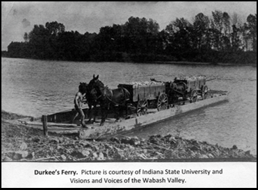
The Wabash & Erie Canal was built across the river from Durkee’s Ferry on the east edge of the river bottoms. Heading east from the ferry, the road split. One split, turned south toward Terre Haute and crossed the canal at Bridge #88. The other split, went due east and crossed the canal at Bridge #87. Between those 2 bridges was the aqueduct over Otter Creek (Aqueduct #13). Today no public roads exist across the river bottoms on the east side of the Durkee’s Ferry landing.
 Land records and ferry franchise records indicate Durkee’s Ferry (1818) was operating before Beard and Lusk bought the land (1819). Durkee operated the ferry on Beard’s and Lusk’s land until 1823 when Durkee and Barbour bought the property from them.
Dr. John Durkee (1770-1834) came to Terre Haute in 1816 from Vermont. He later moved to Tippecanoe County, Indiana. Durkee is credited with establishing the first ferry on the Wabash River in Vigo County, Indiana. One account claims it was the first ferry north of Vincennes. (A ferry license was granted to Robert Buntin in June of 1796 by the authority of the governor of the Northwest Territory. It is believed this was the first ferry to operate on the Wabash. It was granted “for the convenience of Knox County.”) The History of Vigo and Parke Counties states that in August of 1818 a franchise was granted by the state of Indiana to John Durkee and Salmon Lusk to operate a ferry. The license cost Durkee $5. A ferry license at that time in history was considered to be as good as a gold mine. The license stipulated that Durkee was to maintain a large flat boat big enough to hold a wagon with a team of 4 horses and a pirogue (a canoe made by hollowing a tree trunk) to carry foot passengers. Durkee was to have sufficient men to operate both the large flat boat and the pirogue. Durkee’s ferry was operated on demand, not on a regular time basis. In summer, the price for a man and team was $.25 and in winter it was $.37½. A horse and man cost $.12½, while cattle and sheep were $.06¼.
Named on the ferry license with Durkee was Salmon Lusk (1788-1869). Some claim Lusk was a captain under William Henry Harrison at the Battle of Tippecanoe and that Lusk was granted land for his service. The records only show that he served as a private under Major Chunn at Fort Harrison (Terre Haute) around 1816. A bounty land grant to him could not be located. According to the National Archives War of 1812 pension application file, Salmon Lusk served as a substitute for Jacob Davis. Lusk, like Durkee, was from Vermont.
Salmon was married to Mary Beard, daughter of his partner John Beard, on the 19th or 20th of November, 1819, by Dr. Charles B. Modesitt, J.P.. Modesitt had also established a ferry on the Wabash in 1818 and was licensed a few months after Durkee. Modesitt’s ferry is considered the first regular ferry to operate on the Wabash in Vigo County.
According to Bureau of Land Management records, in 1823 John Durkee and Daniel Barbour bought 253.9 acres from John Beard and Salmon Lusk. The records show John Durkee assignee of John Beard and Daniel Barbour assignee of Salmon Lusk. Lusk and Beard had purchased the land together in 1819 according to the Indiana Digital Archives. The BLM does not show Lusk and Beard’s original purchase of the land. This transaction is listed as one land acquisition. This implies that Durkee and Barbour bought Lusk and Beard out. By 1823, Lusk owned 320 acres in Vermillion County and 72.25 acres in Parke County. Lusk at one time or another owned 47 parcels of land in Vigo (1), Vermillion (7), and Parke (39) counties.
On November 15, 1825, Salmon Lusk purchased 99.10 acres in Parke County. It was located north of West Union, Indiana, on what is now known as Towpath Road. This is the location of the West Union covered bridge over Sugar Creek. This land would later include the aqueduct over Sugar Creek for the Wabash & Erie Canal. Just to the north would be Ludwig’s Basin for the canal. The Indiana Digital Archives gives Lusk’s place of residence at the time of this land purchase as Vermillion County, Indiana.
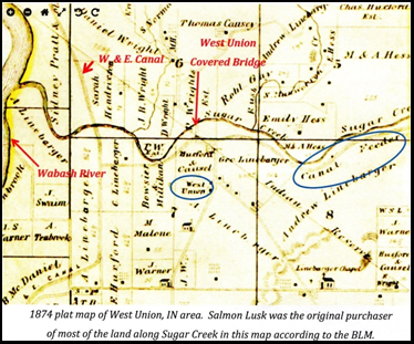
In April of 1826, the Lusk family moved to the Narrows in Sugar Creek Township, Parke County, Indiana. The Lusks erected a mill with 3 burrs and a saw. They did a good business in grinding, sawing, and pork packing. As many as 20 flatboats a year were sent by the Lusks to New Orleans.
The Lusks would have been living at the Narrows at the time of the construction and operation of the Wabash & Erie Canal, not far from Coke Hollow and the feeder canal near the Devil’s Den, which was land Salmon also owned at one time. Salmon owned most of the land along Sugar Creek from where it empties into the Wabash River to the west edge of Shades State Park.
Courtesy of the
Indiana Album
John Lusk, son of Salmon and Mary Lusk, never married. He lived his entire life at the Narrows in the house he, his father, and his siblings had built. John by all accounts was eccentric. Because of Salmon and John Lusk, conservationists were able to obtain some pristine land that is today Turkey Run State Park. The movement to preserve it received financial help from many including the Indianapolis Motor Speedway. The 1847 brick house the Lusks built above the Narrows in what became Turkey Run State Park is open to the public at certain times.
Floods Disastrous to Wabash & Erie Canal
By Carolyn Schmidt
The Wabash & Erie Canal had disastrous flooding in 1828 and 1858 that destroyed many canal structures as well as the canal embankments. When these structures and embankments were washed away the canal was inoperative until repairs were made. These repairs, along with the loss of tolls, were very costly. The more quickly the repairs could be made and navigation resumed the less tolls were lost. Those who were in charge of quickly repairing the canal and building even stronger structures than before were praised for their efforts.
In the 1859 Journal of the Indiana State Senate Thomas Dowling, Resident Trustee, reported to the General Assembly of the State of Indiana the following:
“The [Wabash & Erie] Canal was opened for navigation on the 5th day of April last [1858], after the usual winter suspension, and closed by ice on the 8th day of December.
“The Trustees have to report a series of disasters to the Canal in the month of June last [1858], caused by the excessive floods beginning on the 8th of the month, by which great damage was done to the structures and embankments between Delphi and Terre Haute. The rains which fell during the entire month of May, and which proved so disastrous to agricultural industry, came in full force on the 8th and 9th of June, raising the river [Wabash] and creeks in the Wabash valley higher than they had been since 1828, and at most points higher even than in that disastrous year. These floods extended over a large portion of Ohio, Indiana and Illinois, and the damage sustained by various public improvements was immense. The Canal under our charge sustained a full share of the general ruin which followed the overflow referred to.
“By referring to the report of the Chief and Resident Engineers, hereto appended, it will be perceived that the greatest amount of damage was sustained on that portion of the Canal between Wild Cat creek and the Wea, both inclusive, covering a distance of some six miles. The abutment of the dam at Wild Cat, and the fine bridge over that creek, were swept away, the Canal itself, for forty rods north of the creek, filled with sand and gravel, and a portion of the embankment carried out by the flood. The damage at Wea creek was equally disastrous. The aqueduct over that creek, consisting of three spans, supported by two abutments and two piers (in all 140 feet long), was also destroyed, and several heavy breaks made in the embankments and feeder. The aqueduct over Shawnee creek, 90 feet long, was likewise destroyed, with the exception of the north abutment. The feeder dam at that point was likewise seriously damaged, two heavy breaks made in the feeder bank, and three in the Canal embankment between Attica and Shawnee.
“At Coal creek, in Parke county, a serious breach was made in the guard bank at that place, permitting the whole stream to pass around the dam and across the high banks of the Canal, carrying out at both about 25,000 cubic yards of embankment. No injury was done to the dam or guard-lock, and the wooden structures remained unimpaired.
“The next serious damage south of Coal creek was at Spring creek, where a culvert was washed out, and some slight injuries done to the embankment at that point. The Otter creek aqueduct and embankment adjoining received slight damage likewise. The most serious injury to the Canal in the neighborhood of Terre Haute, however, was the washing away of forty-six rods of embankment within the limits of the city, carrying out some 14,000 yards of sand and gravel, and completely destroying that portion of the Canal under the bluff banks of the river. This embankment stood all the freshets of the river for nine years, without any apparent injury, and its destruction in June last was caused, doubtless, by the building of the piers of the river bridge of the Terre Haute and Alton Railroad, just above the site of the embankment. These piers have formed new channels in the river, and forced the heavy current of the Wabash directly against the embankment of the Canal, causing a constant washing of the base thereof, and undermining the loose materials which compose it.
“These enumerated cases comprise the chief damage to the Canal north of Terre Haute, with slight embrasures in the embankments at various points, which were repaired in time to secure the flow of water from the feeders on the resumption of navigation. The entire outlay for these repairs, as per vouchers furnished, amounts to $55,439.31. It is a just tribute to the officers charged with these repairs to say that the greatest energy was displayed by them, and by all employed under their direction, in putting the Canal in order for the fall trade, and that no effort was spared to secure the early resumption of navigation. When it is considered that the most expensive structures had to be rebuilt, and with materials obtained at distances of from ten to thirty miles, and at a season of the year when the labor of the country was in constant demand, some idea may be formed of the judgment, skill and energy with which the Chief Engineer and his assistants labored to repair the waste and destruction caused by the floods. The structures are rebuilt in the most substantial manner, and the Trustees are gratified in being able to state that the Canal north of Montezuma is in better condition than it has been since its construction.
By this unlooked for disaster the active operations of navigation were materially retarded north of Terre Haute, on that portion of the Canal which has heretofore secured the largest amount of trade and give the most satisfactory revenue. This suspension of navigation materially diminished this year’s receipts, and has greatly curtailed the means at the disposal of the Board. From the 10th of June to the 26th of August navigation was entirely cut off from Delphi to Terre Haute, and at the latter date boats loaded and cleared from Lafayette to Toledo, and shortly after that time the water was passed down to Attica, and as soon as it was possible to fill the levels in the dry month of September, to Perrysville, Montezuma and Terre Haute. Though the season of navigation was far advanced before the re-opening, the tolls on the Canal north of Terre Haute for the months of September, October and November, as reported by the collectors, amounted to the sum of $32,755.40.”
Source:
Journal of the Indiana State Senate, During the Forthieth Session of the General Assembly, Commencing Thursday, January 6, 1859. Indianapolis, IN/ John C. Walker State Printer, 1859.
Junction of W & E Canal and St. Joe Feeder Canal
This is probably the best map CSI Headquarters has seen of the junction of the Wabash & Erie Canal with the St. Joe Feeder Canal. Note that the top of the map is West and should be read accordingly. The map says the summit of the canal is 162 feet above Lake Erie.
The biggest W&E Canal basin in Ft. Wayne was located on the west side of the St. Marys River. The main towpath was on the north side of the aqueduct and basin The towpath also ran along the feeder canal, which was navigable. A towing bridge allowed the mules/horses to cross the west end of the basin. Canals boats passing through town had to make a turn, pass through the covered aqueduct and make a tight turn into either the mainline canal or the feeder to continue its journey. Today this basin has been filled in and is a railroad yard. Only the west abutment of the aqueduct remains.
Note the ice houses of Ed Seidle and P. Morgan, the boat yard where canal boats were built by Barthold with his residence on the other side of the feeder canal. Note also the Orff Mill that used canal water and emptied into the St. Marys River. Also shown are the homes of George Ewing, Wm. Rockhill, Hugh McCulloch, who was Lincoln’s Secretary of the Treasury, and Mother Honey. Nebraska on the left was named so because city folk thought the area was far away like Nebraska.

Miami & Erie Canal Elopement
On September 1, 1838, the Richmond Palladium of Richmond, Indiana, carried an article previously published in the Cincinnati Chronicle about a young couple eloping by canal boat on the Miami and Erie Canal in Ohio. It is quoted below in its entirety:
A Runaway-Match
We chanced, two or three weeks since, to be descending the Miami Canal, from Dayton to this city [Cincinnati], in the packet ‘Clarion,’ Captain Brockaway, commander. The boat had overcome some 25 or 30 miles of the distance, when the tramp of a horseman was heard upon the tow path. In a minute a gallant steed was beside us, covered with foam and panting with the heat. On his back was a surly looking Dutchman, in years some forty five or fifty, of middle stature, with short legs and still shorter stirrups, and sitting in his saddle very much as Sir Monkey rides his pony in the menagerie. His appearance quickly attracted the eyes of the crew and passengers, especially as his throat well lined with dust and dried by the heat, gave utterance to sundry violent and incoherent sounds, which were ever and anon accompanied by a threatening flourish of a short whip which he held in his right hand. At length we caught the words, “Mine dawter–Captain, give me back mine dawter.” The passengers began to look at the captain of the ‘Clarion,’ who by the way is a modest looking, gentlemanly sort of a bachelor, to know what all this meant. The captain protested he knew nothing of the Dutchman’s ‘dawter.’ The old man kept howling most vehemently, ‘mine dawter, give me mine dawter.’
The captain now stopped his boat, and called to the enraged horseman to come on board and take his ‘dawter.’ In an instant, he had dismounted, tied his jaded steed to the fence and was in the cabin of the boat. With a quick step and a hurried eye, he looked round–she was not there. He passed on to the ladies cabin, searched it, but with no better success. He returned to the main cabin, and his eye rested upon a young German, asleep on a settee, who had probably escaped his notice as he passed through. ‘Love’s young dream’ was most unceremoniously disturbed, for the old man sprang at him like a tiger, caught him by the collar, and cried out, ‘you damn rascal, where’s ‘mine dawter?’ The sleeping bridegroom stood upon his feet in utter amazement and affright, and instantly pointed to the ladies’ cabin. The old man released him again rushed to the ladies cabin, searched it a second time, but without success.
By this time the captain of the ‘Clarion,’ having become impatient, ordered the boat to start, and the old ‘dawter’-hunter jumped on shore, and mounting his horse, kept by the side of the boat, calling out for his ‘dawter,’ and threatening to pursue the captain to Cincinnati and there reclaim his runaway child, when he would give her ‘Germany,’ shaking his rod most significantly towards the boat.
We now learned that the fair runaway, was a sober looking little Dutch girl, in a pink dress, who had eaten her dinner in silence, and who, upon hearing her father’s voice, had, by the aid of the ladies, concealed herself, so effectually in the cabin, that her father, even by the aid of the craven lover, could not find her. We further learn that her parents were opposed to her marrying this young man, and that they had that morning eloped, from Dayton and having taken the canal boat, for greater speed, were on their way to some Gretna Green, in order to have the knot matrimonial, duly tied.
Presently, the old man resolved upon a new course of action, and set off full speed for Hamilton to invoke the aid of the Sheriff in searching the boat for ‘mine dawter.’ The bridegroom, who had been ‘mightily scared’ by the violence of the old man, now became more composed. He asserted that the young lady was nineteen years old, and enquired, with considerable anxiety, whether her father could take her back, even if he got the Sheriff. One of the passengers observing that his nervous system was a good deal disturbed, and desirous of having some sport, remarked in a suppressed tone, but so as to be heard by the groom, ‘It’s a pity the old man has brought them big pistols with him.–I fear there will be blood-shed.’ ‘Has he pistols?’ inquired the groom in utter consternation, and passing quickly from the bow of the boat to the ladies cabin, with his bundle of clothes in his hand, proposed to his lady-love, that he should jump on shore, escape to the woods and leave her to the tender mercies of her father, to be taken back to Dayton. But his lady-love had no idea of losing a husband and gaining the parental rod. She quickly put her foot upon the floor with much significancy and said, ‘No, you shall do no such thing.’
Here was a pretty quandary for a nervous lover to be in–pistols on one side and a resolute young lady on the other. Flight was impossible, death seemed almost certain. The groom stood motionless and speechless,. Some of the ladies in the cabin proposed that they should both leave the boat and take to the woods. This proposition suited the young lady exactly, and her gallant lover was ready for any expedient that would carry him speedily from the aforesaid pistols.
The boat was stopped, the lovers jumped on shore, the groom leading the way with one, the bride following with two bundles, in which were no doubt the bridal dress and its necessary appurtenances. They crossed a bridge in hot haste, to get on the opposite side of the canal from the pistol bearer, and made for the woods at the top of their speed, the groom leading the bride some twenty paces. The passengers rushed to the deck of the boat and made the welkin ring with their shouts. One of them called out, ‘You craven loon! Carry your sweet-heart’s bundles, or we’ll come and Lynch you.’ The flying lover took the hint, ran back, seized the largest of the young lady’s brace of bundles, and again set off full speed, for the woods. The bride pursued with all becoming alacrity, and just as they reached the edge of a copse, their speed was very considerably quickened by one of the passengers crying out–‘haste, haste, the old one is coming.’
The boat had proceeded but a few hundred yards before we met the old man. The idea of such a flight as we had just witnessed, had occurred to him, and he had turned round to watch the packet down to Hamilton. Upon being assured that his ‘dawter’ and her lover had escaped from the boat, he put whip to his horse and set off in pursuit of them, to the great amusement of the passengers, who united in opinion that they had now seen a real runaway match.
As yet we have been unable to learn the result of this youthful and loving flight. It proves once again, that the ‘course of true love never did run smooth,’ albeit, it now and then runneth very fast.
Montezuma Canal Basin Marked

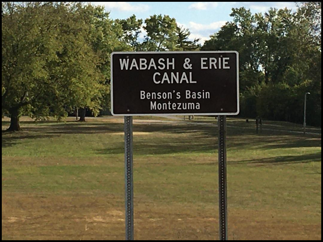
In early October 2020 the sign furnished by the Canal Society of Indiana was installed at Reeder Park in Montezuma, Indiana right in front of Benson’s Basin. The Wabash & Erie Canal towpath runs between the basin and the Wabash river. Diana Bartlow, who was in charge of getting the marker erected, writes: “We sincerely appreciate your consideration! Thank you so much!”
Reeder Park is highly used by Montezuma residents. The marker will be noticed by many people at this location. Thanks to Diana and her crew! Hip Hip Hooray!
Col. Erastuls M. Benson formed a partnership with John D. Davis, Clerk of Parke county in 1846, and opened a general merchandise business in anticipation of the coming of the canal. It was large and flourishing. It grew into a wholesale buying and selling business and had a big warehouse on the canal basin 150 yards north of the artesian well. This warehouse was managed by Septimus Vanlandingham. After his warehouse was torn down, the Montezuma Sanatorium and Hotel was built at this site in 1906. In the 1860s-70s Benson owned and operated one of the largest slaughter houses in western Indiana.
Whitewater Canal and River Marker Erected
John Hillman, president of the Whitewater Valley Scenic Railroad, has erected the Whitewater Canal and River Marker near the site of the aqueduct that once carried the Whitewater Canal over the river. He put it before the aqueduct site is reached by the train when entering Laurel from the south for two reasons. It will be seen by train passengers before they reach the site near Laurel and the river is behind it, which should discourage vandalism. John reports that all the CSI sponsored signage that has previously been placed along the route of the railroad marking the canal is still in good condition and has not been vandalized. He is just being cautious.
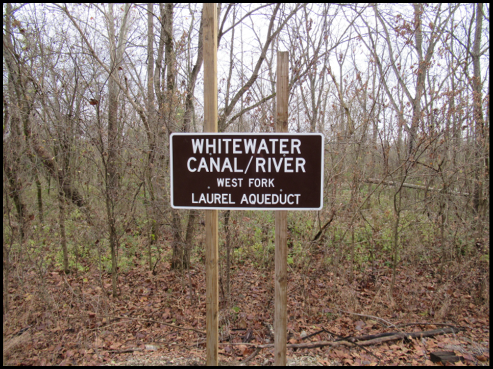
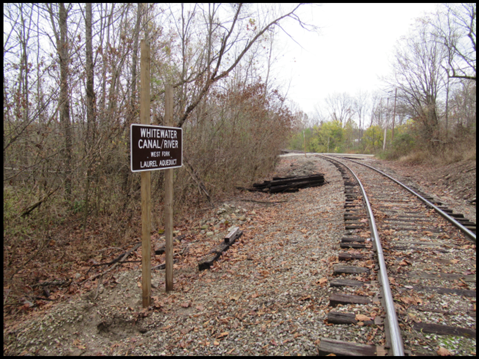
CSI thanks John for placing the marker and those that were previously placed to point out the locks of the Whitewater Canal and the Laurel Feeder Dam. Hip Hip Hooray!
Fall Drive
 Last October 11, 2020, after many days of maintaining distancing for the virus, Tom and Diane Fledderjohann, CSI members from New Bremen, Ohio, decided they needed a break and took a drive around Spencerville, Ohio. They stopped at the sign on the towpath of the Miami and Erie Canal for the Deep Cut. Diane said the foliage along the canal was beautiful.
Following canals was a good way to get out and about. Several other CSI members said they took trips along canal routes. The autumn colors were really outstanding this year.
CSI Welcomes Aboard Ball State Student Savannah Baker to Publish “The Tumble” and CSI Website

My name is Savannah Baker, and I’m excited to be working with the Canal Society of Indiana! I am very extroverted and love to talk to and meet new people. I have six siblings, so being around people reminds me of home. I’m twenty years old and I grew up in Westfield, Indiana. I go to Ball State and I’m studying Psychology and Applied Behavior Analysis. I love music, coffee, sunshine, kids, animals, and nature! I write my own music in my free time, and I also love to travel. I am passionate about helping others. Some things I would consider very important to me are my family, friends, and my education. My biggest goal in life is simply to be happy.
In Memoriam

March 13, 1949
October 21, 2020
Mary (Ricks) Hatch, 71, of Fort Wayne, passed away on Wednesday, October 21, 2020. She was born on March 13, 1949, to Charles and Marcile (Brookshire) Ricks of Ossian, Indiana.
Mary attended Ossian schools and was active in 4-H, Girl Scouts and her church. She was graduated from Ossian High School in 1967 where she had been a baton twirler. While still a teenager, she was the first female graduate of Reppert School of Auctioneering.
She enrolled in Indiana Wesleyan University and later transferred to Huntington University, from which she obtained a degree in Analytical Chemistry in May 1971. In April, just before graduation, she was married to Richard (Dick) Hatch and the couple moved to Ft. Wayne.
Mary worked in Product Quality at Central Soya in Decatur, Indiana for about two years before working in Environmental Health and Safety at General Electric in Ft. Wayne until 1982. She spent a couple of years at A&L Great Lakes Agricultural Laboratories before moving to ITT Aerospace Optical working in Corporate Compliance and was a Certified Hazardous Materials Manager. She retired in 2010 after 25 years of service.
In 1980 Brooke, Mary’s daughter was born. Brooke later married Christopher Calderon and they had a daughter, Persephone.
After retirement Mary had more time to pursue her interest in Frank Lloyd Wright, be active in Three Rivers Wesleyan Church, add to her collection of antique medical books, and travel the world. She visited all 50 states, Mexico, Canada, the Caribbean and Australia.
In 2017 she was diagnosed with Frontotemporal Dementia which eventually led to her death. A public celebration of her life was delayed due to COVID-19.
Mary is survived by her husband, Richard (Dick); daughter, Brooke (Christopher) Calderon of Concord, California; and granddaughter, Persephone Calderon.
Mary and Dick Hatch have been members of the Canal Society of Indiana for 12 years. Although they were unable to attend tours, they generously supported CSI through their donations. CSI headquarters is housed in their previous home, which was purchased by Bob and Carolyn Schmidt.
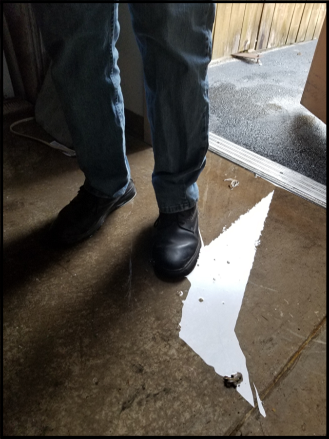
Canal Conference Center in Delphi Flooded
From Janet Ayres
The Canal Center had a little disaster on Sunday, November 15, 2020. Two water pipes broke and flooded it. The backroom, kitchen and museum had about an inch or so of water. Unfortunately, the conference room had puddles of standing water and was very discouraging. It will need new carpeting. The front entrance, lobby, restrooms and desk area are dry. Interesting how water flows in a building!
Delphi was without power due to high winds. Dan McCain could not call out so he drove over to my place and we went to the Center to figure out what to do. We called the City of Delphi to help turn off the water and stop the incoming flow of water. Since there was no power, this was all we could do that night.
The attached photos taken on Sunday afternoon show Dan’s feet in the water (this didn’t do a very good job of showing the depth of water) and the flooded conference room.
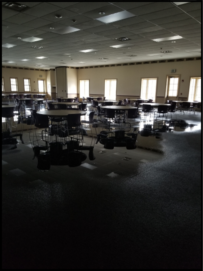
On November 16 Hays and Son, restoration specialists, were at the Canal Center all day with a work crew. They took off the baseboard and got in under the displays in the museum. They had many, many fans and dehumidifiers going. Of course they are concerned about all the areas where the water seeped into or was absorbed such as cabinets in kitchen. Drywall and insulation are concerning. They said they would have their equipment there at least through Friday and possibly through the weekend.
The insurance adjuster and plumber were there at same time so we could get everyone on the same page. The insurance adjuster, a water specialist, said we had a “tremendous” amount of water in the building and it will be a huge insurance claim. We are very glad we have good insurance!
Canal Word Puzzles
CSI members have received puzzles by E-mail during the Coronavirus quarantine. These have been scrambled canal words, canal word searches and canal quotes. Those who have sent in the correct answers since the November issue of “The Tumble” are as follows:

News From The Past
These short articles were found while looking for topics for CSI’s daily “Day in Indiana History” E-mails to members. Many of them are reprints from other newspapers, which was a common practice in those days.
Indiana Palladium, Lawrenceburg, Ind.
October 19, 1833
MIAMI CANAL.
It was expected that this canal would have been completed to the river, during 1833. The season has been such as to render this impracticable. From Court Street to the River, ten locks are to be constructed. All of these are partly prepared, one only completed. They are built of the most substantial materials, and in the most durable manner. Mr. Laughry, the undertaker, is a practical mason, and has evinced a good stock of mechanical pride, as well as skill, in their construction. It is a pleasant walk, of a dry day, to traverse the line of the canal from where it crosses Main street to the river, and observe the work in its present progress. It cannot fail to excite reflections highly pleasurable to any mind disposed to rejoice at the successful efforts of our almost infant State, and to anticipate with satisfaction, the point of greatness to which she may arrive, if she continues as she has commenced in the construction of public works.
Cincinnati Gaz.
Indiana Palladium, Lawrenceburg, Ind.
October 19, 1833
Wabash and Erie Canal. —Here is another magnificent work under way in the west—another tie between the Lakes and the Mississippi. Indiana, young as she is, is determined not to be behind Ohio in enterprise. Thirty-two miles of the line of this Canal, extending from within a mile of the Maumee to Huntington on the Wabash, will be completed within one year.
We have once before spoken of the fertility of the soil through which the canal is located, the cheap price at which it may now be had, and the rapidity with which it is settling. An economical laborer, at the wages paid upon the canal, can in one year, make himself the proprietor of a tract of land—land unsurpassed in richness in America—sufficient to render him and his family not only independent, but wealthy. And the land can be procured within five miles of the line of the canal. The advantages of a settlement in that district are too obvious to require specification. The settlers, when the canal is completed, will have the choice of the New York, Montreal and New Orleans markets, in this respect enjoying good facilities with the inhabitants residing upon the Ohio canal. — Cincinnati Republican.
Indiana American, Brookville
October 20, 1843
Canal and Steamboat Line.
The Canal Boat Patriot will leave Brookville every Monday and Thursday at 9 o’clock a.m. and arrive at Lawrenceburgh at 7 o’clock p.m. where the Steamboat Fashion will be in readiness and run to Cincinnati the same night; and leave Cincinnati Tuesdays and Fridays at 12 o’clock and arrive at Brookville the same night. The Fashion is a first rate boat; and the Patriot is the neatest and best boat on the Canal, and the most convenient for freight and passage. As the hard times and competition have made freighting lower than usual, the owners of the Patriot will not be outdone by any. Passage one dollar through (including boarding). The Patriot is commanded by H. Colescott, The Fashion by John H. Baldwin. All kinds of business will be attended to by the Masters of the Boats on the most responsible terms.
WAREHOUSE
- Rockafeller has a large Ware House at the Canal Basin in Brookville, where all freight intended for the above line will be received free of charge, and a man always at the house to attend to business.
- ROCKAFELLER,
- COLESCOTT.
Brookville June 12, 1848
Indiana State Sentinel, Indianapolis
October 21, 1848
WABASH RAPIDS.—The improvement of this part of the river is going on finely. The company having taken the work into their own hands, are vigorously prosecuting this work, and it will be but a few weeks more until boats will be able to pass through the ‘lock.’ —Vincennes Gazette
Indiana State Sentinel, Indianapolis
October 21, 1948
THE FATE OF A CANAL.—New Haven [Connecticut] papers are making merry over the destruction of the old canal, once the boast of Connecticut, but now, like a faded beauty devoid of intellectual or moral worth, it is thrown aside and neglected for the more useful railway. There is hardly a vestige of the old canal remaining.
Richmond Palladium, Richmond
October 21, 1843
The stock of Flour in the New York city market is estimated at 200,000 barrels, against 50,000 barrels at this time last year.
The quantity of Flour received at Albany, by way of the Erie Canal, from the commencement of navigation this season on the 22d ult. was 1,139,357 barrels, and of Wheat, 457,477 bushels.
There were received at Albany, during the week ending on the 22d of September, 72,636 barrels of Flour, and 40,960 bushels of Wheat.
The receipts of tolls on all the Canals of the State of New York, this season, up to the 22d ult., amounted to $1,347,072.—Balt. American
Wabash Courier, Terre Haute
October 21, 1843
Canal Scrip.
THERE are some few of my friends indebted to me in small amounts, who now have the chance of paying off in Canal Scrip, at fifty cents on the dollar, and I would respectfully call on all such to come forward, as I wish to sell low for Cash or Barter, and intend making no booked accounts.
JOHN REINHARD,
Sign of the Spinning Wheel,
North East Corner of the Public Square.
Evansville Daily Journal, Evansville
October 21, 1848
Canal Letting.
NOTICE TO CONTRACTORS.
The undersigned Trustees of the Wabash and Erie Canal hereby give notice that they will receive sealed proposals at Point Commerce in Greene County, Indiana, on the 15th day of November next, for the construction of 17 miles of said Canal, extending along the valley of the west fork of White River, from Point Commerce to the village of Newberry in said County. On this division, there are to be constructed 6 Lift Locks, and a Guard Lock, a dam across White River, 12 feet in height and over 400 feet in length, together with the usual variety of work belonging to a Canal. The line will be divided into sections averaging about half a mile in length.
At the same time and place, proposals will be received for the performance of a part of the Rock Excavation at the Patoka Summit, in Pike County.—This section will embrace near 20,000 cubic years of solid rock, varying in depth from 4 to 15 feet, together with a portion of earth excavation.
The work to be done will be ready for inspection for two weeks previous to the day of letting, during which time all necessary information will be given by the Resident Engineer.
Payment will be made as the work progresses, in par funds.
CHARLES BUTLER,
- M. PUETT, Trustees
THOS. H. BLAKE
OFFICE OF THE BOARD OF TRUSTEES,
Terre Haute, Ind. Sep. 7, 1848
Jasper Weekly Courier, Jasper, IN
October 29, 1915
CANAL BLOCKED FOR MONTH
War Department Will Refund Advance Dues of Delayed Ships—Troops Go into Camp
Washington, Oct. 8—No proclamation will be issued by President Wilson formally closing to navigation the Panama canal blocked by earth slides. War department officials said there was no necessity to such action, as nature had already closed the waterway for a month at least. The department approved the recommendation of acting Governor Harding that dues paid in advance by delayed vessels be refunded. The Twenty-seventh infantry, on route to the Philippines via the canal, has been ordered into camp.
 2019-2020 – President’s Review of CSI
Despite the challenges of this past year, our canal society continues to create new ways to keep in touch with our membership. As you are well aware we had to cancel both our Spring & Fall tours and even our annual Board meeting. Our bi-monthly publication, The Tumble, is being issued on the regular schedule despite the fact that Ball State had to close down some of it’s facilities that we normally use. We have created two new E-mail communications with our membership that, based on the members’ responses, have been quite well received. “Day in Indiana History” is a factual E-mail based on events that occurred during the past in the Hoosier State. It has generated responses from members with additional information that we pass on to others. It is good for members to have this direct communication. The second feature that has been added are puzzles: word searches and canal quotes. Through these activities we have reached out to different members that we have had little contact with before.
Two of our newest board members have made outstanding contributions to our website and to canal research. Preston Richardt was added to the Board this past year. During the year he has placed the Wabash & Erie Canal onto a Google map. This map shows the canal route on today’s map and pin points the location of canal structures. We hope to enhance this map with photos in the coming year. Board member David Kurvach has been busy going to remote canal sites and making video recordings with narration in Warrick and Greene counties. They are like being there in person. I can’t give enough praise to both of these men’s efforts to enhance canal information. Sam Ligget, also a CSI director, has narrated a video about W & E Culvert timbers in Terre Haute. All of this excellent work is now accessible on our website.
I also want to thank all the directors who wrote or contributed articles for “The Tumble.” You have been very helpful in providing new and more local view points.
Thanks to all of you who worked in getting CSI signs placed along Indiana’s canals. Our signage program continues but has been delayed in getting some installations completed. The Hagerstown canal sign has been placed at its terminus in Cambridge City, the Benson’s Basin sign in Montezuma has been erected and the Laurel Aqueduct sign on the Whitewater Valley Scenic Railroad has been installed. The signage at Delphi should be in place soon. We need to identify new sites for 2021.
Our dues will remain at $20 single/family per year. Any additional contributions will be used for our signage program.
Our current financial situation is good. The virus created very little negative financial impact on CSI. The work on the website by Ball State has been substantially reduced, this being our major expense. Preston and David have each added to our website without incurring any expenses that previously would have been incurred from Ball State. Since we have gone completely electronic in our publications, the virus created much less disruption than if we had had to deal with printing materials and the postal service.
Our contact at Ball State, Cate Smith, will be doing her student teaching in the upcoming Spring Semester, so a new person is coming onboard. Her name is Savannah Baker. She is a freshman and hopefully will continue working with us for the next four years. In addition to putting your canal related articles in The Tumble on our website, she will be loading prior issues of The Hoosier Packet online, keeping our listing of the board of directors up to date, and loading any videos or maps as needed.
We lost the following key supporters of Indiana canals this past year: Past CSI director, Chuck Whiting of Lawrenceburg; prior CSI president, Jim Hicks of Brazil; and CSI members, Guy Filchak of Clinton and Mary Hatch of Ft. Wayne, Indiana. They added greatly to our society and will be missed.
I look forward to another year of progress for CSI. We plan to schedule the 2021 Spring Tour on April 16 -17 in Gibson, Warrick and Vanderburgh counties and the Summer Symposium on Saturday, August 28 in Anderson. This upcoming year we need to concentrate on getting new members. We have 5 life member families.
Next year’s board meeting will be in Fort Wayne on Saturday October 23, 2021. Anyone willing to help with the meeting, please contact me.
I am looking forward to 2021 being a fun-filled, educational year on Indiana’s canals.
Bob Schmidt
President – CSI
REPORTS FROM CSI DIRECTORS (Relating to or promoting Indiana’s or other canals)
Bauer, Carl – Served as CSI representative on the Maumee Valley Heritage Corridor board of directors, Took many pictures of sites along the river and route of the canal
Bodine, Terry – W & E Canal – Covington – CSI Director
This last spring I built a model of a covered bridge that is close to our home. Through digging into early history of our country we discovered another covered bridge down by Lodi, Indiana that was partly paid for by Indiana through the Wabash and Erie Canal. When we get all the details I will write something. Being so busy building the model covered bridge, both Anne and I having health issues, and my son and grandson being busy, I haven’t gotten my sign up yet. We will get it done.
Castaldi, Tom – W & E Canal – Ft. Wayne – CSI Director
Was interviewed for video tape project at Little River Wetlands discussing how transportation Internal Improvements was enhanced through the wetlands upon completion of the Wabash Erie Canal project.
Regular contributor for Forks of Wabash newsletter articles
Continue as Allen County Historian for Indiana Historical Society Local Programming.
Interviews for Eric Olson’s “Your Country” featuring, Fort Wayne’s Old Canal House.
Donated copy of Loveland’s monograph to City of Fort Wayne’s Historic Preservation Dept.
WBOI/In Session: On-line pod cast feature interview “Local History: Canal Development”
Assisted in organizing CSI Symposium for August 22nd event now scheduled for 2021.
Delivered canal signs and reported on their status:
Forks of Wabash: will repair sign and leave at same site.
Lewisburg Road in Cass County: no reply on status after several inquiries.
St. Mary’s Aqueduct. No reply on status after inquires made.
Written articles for “The Tumble.”
Supplied research for “Day in Indiana History” E-mails
Hillman, John – Whitewater Canal – West Harrison – CSI Director
The Whitewater Valley Railroad takes up most of my time.
The CSI aqueduct sign that marks the Whitewater Canal Crossing of the Whitewater River at Laurel, Indiana, has been installed. All other canal signs are in good condition.
Koehler, Jeff – W & E Canal – Clay County – CSI Director
I probably wouldn’t be able to attend a meeting even if you had one.
I was supposed to speak at the State Genealogical Society meeting for two sessions. One on the Wabash and Erie Canal and the other on the Interurban. It was Canceled!
I was also supposed to speak in Huntington, Indiana at the Dr. James Ford Home. It was also Canceled! They are wanting me to do a video of my presentation. It will have to wait until after our harvest is over before that can happen.
All of our Canal marker signs are either missing or broken. I put up the CSI one on the Splunge Creek Reservoir, but it didn’t last a week before it was stolen. I have the remaining State format marker in our shop. It is Broken and will cost us $450 to get it fixed. I am reluctant to put it back up for fear of it getting stolen or broken.
Kurvach, David – W & E Canal – Warrick County—CSI Director
Took pictures and wrote an article for “The Tumble”
Worked with Stan Schmitt and Preston Richardt in planning the CSI tour that was rescheduled for next spring
Filming and field studies in both Warrick and Greene Counties (the latter focusing on the slackwater section on the West Fork White River)
Trying to get Greene County Historical Society involved in the ruins of Lock 59
Illustrations on how the slackwater section of the Wabash & Erie Canal worked (which is in its infancy)
Had two CSI canal signs installed:
First two Warrick County signs are up. First one located on Tow Path Road, about 1,500 yards north of Heim Road, marking what I feel is the best preserved section of canal one may view from Tow Path Road without leaving their vehicle. Second one is located at the northeast corner of the intersection of Tow Path and Warrickton Roads. This was placed for two reasons: (1) this marks the southern end of the second best preserved section of canal along Tow Path Road, but Tow Path Road becomes a poorly maintained road north of Warrickton Road and the county would not place the signage anywhere north of the intersection and (2) the property it sits on is owned by Mr. and Mrs. Merta, the former is a retired Warrick County Sheriff and pledged he would do what was within his power to look after the sign. The Mertas also own the 1,000 yards of preserved canal north of the sign …and have done a great job cleaning out debris and fallen trees from the bed.
I’m using these two signs as tests to how long a sign can last in rural Warrick County. I have a few other areas in mind for future signage…but I want to see how the two fare over the next year before marking other areas of the canal in Warrick County.
Ligget, Sam – W & E Canal – Terre Haute – CSI Director
I made arrangements with a property owners to erect a canal sign at Ferree and Erie Canal roads on the south side of Terre Haute. On March 17, 2020, I, along with Leon Billing and my grandson Eli Elkins, erected the sign. I contacted the Bartlows about erecting a canal sign at Benson’s Basin in Montezuma, Indiana. I wrote articles for “The Tumble” and am researching a future one. I also delivered old issues of “The Hoosier Packet” to the Bartlows in Montezuma.
Normally the Vigo County Park Department has Pioneer Days at the end of October, but this year they are going to do it virtually. I was asked by Adam Grossman, head of the Park Department, to talk about the timbers, which were removed from Culvert 151 of the Wabash & Erie Canal when the 641 by pass was built, in a short segment of the program. I accepted. At first the timbers were placed in the Fowler Park lake in Terre Haute. Later the lake had to be drained and the timbers removed. They used some of the timbers to build a nice shelter. The video can now be seen on the Canal Society’s website.
McCain, Dan – W & E Canal – Delphi – CSI Director
Pretty slow this year due to COVID-19. Canal Interpretive Center building and Museum fully closed but the Pioneer Village and Trails are open to outside visiting. Work still goes on with the Monday-Wednesday-Friday crew. We had intended on opening three overnight rental log cabins associated with our RV Park. But they were not quite completed and we never offered them for rent. RV Park is limited to only “fully self-contained” units as we don’t offer restrooms or showers. RV sites have been pretty well filled this summer and we have a resident “camp host” doing a great job managing the park. We have kept the grounds up and the park looks great. Flower beds are well cared for and many visitors do spend hours coming to the park for picnics, wandering through the Village and hiking the Trails.
The Canal Boat “Delphi” never had a public run but did get fully repainted and looks great. There will be a fall event with a group of Indy photographers that have rented it to cruise the waterway and take pictures. We hope to get some new photos we can use from their efforts.
Inside the Canal Interpretive Center we have only had a couple events like weddings and we are not encouraging events—only serving those that booked earlier (most cancelled). We do have a receptionist every weekday and she takes care of requests for information and keeps the mail flowing to the treasurer and board members. We still put out the monthly E-newsletter.
We did get up the Pittsburg Dam sign and received two more to mark the crossing under Highway 39/421/18 but haven’t put them up yet. I, Dan McCain, have been incapacitated with lower back issues and surgery.
The Canal Interpretive Center building was flooded by two pipes that burst in November and is undergoing a serious restoration.
Really appreciate the regular communication from CSI headquarters and “The Tumble” issues. Hoping membership stays up and everybody pays. We will survive, but 2020 will go down as a most unusual year.
Looking forward to next year. We have optimism there will be a regular schedule of events much like the past.
I am on the board of the American Canal Society.
Mattheis, Jerry – Whitewater Canal – Cambridge City – CSI Director
Put up sign for Hagerstown extension to Whitewater Canal in Cambridge City
Had Mark Mattheis take pictures of the sign for the newspaper and The Tumble
Would like to see a CSI sign placed in Whitewater Canal prism on Boyd Road
Take care of canal museum in the Vinton House in Cambridge City
Mattheis, Phyllis – Whitewater Canal – Cambridge City – CSI Director
Helped put up sign for Hagerstown extension to Whitewater Canal in Cambridge City
Wrote an article about the sign for the Western Wayne News
Edited the Whitewater Canal Scenic Byway minutes
Take care of canal museum in the Vinton House in Cambridge City
Morthorst, Mike – Indiana’s Canals – Cincinnati, OH – CSI Vice-President
I am the editor of the Canal Society of Ohio newsletter.
I am secretary for Whitewater Canal Trails and am CSI’s representative to the organization.
I am on the board of the American Canal Society.
I wrote the article “Roaming the Carolinas” for “The Tumble”
Powers, Cynthia – W & E Canal – Roanoke – CSI Treasurer
Wrote checks to pay CSI bills as instructed
Reviewed financial reports with the president, Bob Schmidt
Wrote an article for “The Tumble”
Visited the ice cream shop in Lagro and saw CSI sign for the W & E Dam once located there.
Richardt, Preston – W & E Canal – Gibson County – CSI Director
Created the Google maps of the Wabash Erie Canal in Indiana that is now on the CSI website and will continue adding pictures, etc. to these maps with information provided by CSI directors.
Audited many canal sites, especially in southern Indiana.
Worked on Youtube videos.
Erected CSI signage in Gibson county.
Worked with David Kurvach and Stan Schmitt in planning the tour that has been rescheduled for next spring.
Provided pictures, maps and text for “The Tumble” of the signage, culvert, etc.
Gave a talk about Indiana’s canals at the Patoka Refuge
Schmidt, Bob – W & E Canal – Ft. Wayne – CSI President
Served as CSI president; Planned CSI Board of Directors Meeting, questionnaire and voting forms that were E-mailed to board members; Kept CSI financial records and prepared financial statement; Filed not-for-profit state and federal forms; Wrote articles for “The Tumble”; Arranged to have canal signs made, picked them up in Ohio, and delivered them to the recipients or to other board members to deliver them to recipients; Worked with Preston Richardt in creating a map of Indiana’s canals with structures by county, pictures, and documents; Worked with Ball State student for additions and corrections to CSI website; Researched and wrote “Day in Indiana History” articles that were E-mailed to members; Answered canal questions and mailed material to several people; Picked up CSI mail at Ft. Wayne’s downtown post office; Prepared slate of officers for American Canal Society board of directors where I am the nomination chairman; Viewed CSI signage at Lagro, Huntington, Peru, Ft. Wayne; Delivered CSI signs to Montezuma and Covington
Schmidt, Carolyn – W & E Canal – Ft. Wayne – “The Tumble” Coordiinator
Coordinator for “The Tumble” and wrote articles for it; Prepared CSI Board of Directors meeting year end report booklet; Created weekly canal related word puzzles that were E-mailed to members; Helped with research and writing daily “Day in Indiana History” articles that were E-mailed to members; Answered E-mail questions about canals; Viewed CSI signage at Lagro, Huntington, Peru, Ft. Wayne; Delivered CSI signs to Montezuma and Covington, Sent contribution and memorial letters to those contributing to CSI
Schmitt, Stan -W & E Canal – Evansville – CSI Director
I’m still doing research and finding new things. All programs and presentations were cancelled in 2020. Everything is dependent on life getting back to normal. I am still unable to get an answer on the terminus sign for the Wabash & Erie Canal at Pigeon Creek in Evansville.
Simerman, Sue – W & E Canal – Ft. Wayne – CSI Secretary
Very limited activities. I have visited Delphos – St. Mary’s, Ohio on the Miami and Erie Canal.
In Indiana I’ve been to the Forks of the Wabash at Huntington, Lagro, and seen the sign for the Wabash and Erie Canal at the Wabash River in Peru. I’ve served as the CSI secretary, recorded minutes from the board of directors’ meeting in 2019, and written articles for “The Tumble.”
Timmers, Frank – Central Canal – Carmel – CSI Director
I submitted newspaper clippings with articles for “The Tumble.”
Williams, Steve – W & E Canal – Roanoke – CSI Director
The following have little direct relationship to the canal theme: (Presentations)
Fire in the Rear — L.P. Milligan & copperhead activity during civil
First person interpretation, Lt. Col. Samuel M. Zent, 13th Indiana Vols.
Various local history topics
The Canal Society of Indiana thanks all of its Directors for their service this past year.