
Articles for the Tumble – September 2025
Canal Restoration in Indiana
By Robert F. Schmidt, Canal Society of Indiana
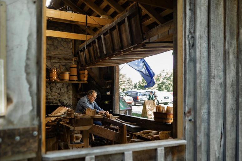
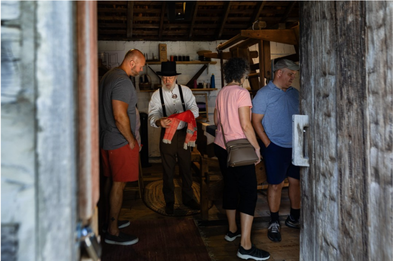
The Whitewater Canal Historic Site was established in 1946 along 16 miles of remnants of the original Whitewater Canal. It contains a feeder dam, several canal locks and the last remaining covered-bridge-style wooden aqueduct in the United States. The town of Metamora, Indiana is the hub of this canal site and offers an operating grist mill, restaurants and a variety of shops.
Hiking trails are available in both directions along the canal prism. Located in the Cincinnati market area, the town conducts many weekend festivals that are the lifeblood of this unincorporated town of 200.
The Whitewater Valley Scenic Railroad runs on weekends from Connersville to Metamora along 19 scenic miles of the old canal route. It brings additional tourists into Metamora on weekends who learn about the canal from a docent aboard the train. It also has special themed rides such as its Polar Express, Civil War days, etc.
For many years, a canal boat ride through the historic aqueduct was a key attraction. The last boat, the Ben Franklin III, became waterlogged, was lifted from the water and overnight fell apart in April 2022.
All of these canal attractions are part of the nationally designated Whitewater Canal Scenic Byway that extends from Hagerstown to Lawrenceburg, Indiana. This is well marked and makes a wonderful auto tour.
The Indiana State Museum and Historic Sites (ISM&HS), which is responsible for this canal site, conducted an engineering study to see what would be required to restore the Laurel feeder dam and the Duck Creek aqueduct and purchase a new canal boat. The cost was estimated to be about $14.4 million and was presented to the Indiana General Assembly for funding. They responded with an offer of $7 million for the project contingent on matching funds from a local or nongovernmental source. The local Franklin County community conducted a variety of fund raisers during the past 2 years but, for an entire county population of just 23,000, it was a monumental task.
To meet its 2025 state budget allocation, the ISM&HS was faced with staff and other cost reductions. By the end of May 2025, the matching funds for the Whitewater project had not been raised. On June 10th ISM&HS announced that the Whitewater Canal Historic Site would be closed in October. Just a few days later the Eli Lilly Foundation announced that a $7 million matching grant had been approved. Necessary papers were signed and it was announced that the site would be restored. The details of this restoration project still need to be finalized, but the future now looks much brighter as the key canal features will be restored, along with a new canal boat and storage dock.
On Saturday, July 19th, an area wide meeting was held at Third Place Event Center in Brookville to develop a strategic plan for the entire Whitewater Valley. This was a planning session involving Indiana Landmarks to help develop alternatives if and when the Indiana State Museum exits the Whitewater site. A temporary Board of Directors was established and Amanda Arcidiacono, Eastern Region Director of Indiana Landmarks that is located in Richmond, agreed to serve as the temporary President. CSI is a supporting member of this organization, but we were unable to attend.
After the Brookville meeting, CSI headquarters received a request for a biography and picture of the person from CSI who would serve on the temporary Board of Directors. CSI president, Dr. Ron Morris has agreed to be on that board. He is well acquainted with the Whitewater Canal and its structures. His biography and picture were sent.

Ronald V. Morris, Ph.D. is the Chair of the Department of History at Ball State University where he is also a professor. He is the author of seven books and over ninety-five articles. He has administered over a million dollars in contracts and grants split between teacher in service and developing media projects for nonprofits. His students have worked with multiple educational, historical, and cultural groups to develop products for non-profit organizations. He presently serves as the President of the Canal Society of Indiana and the Vice President of the Brown County Art Guild. He is in the process of restoring his third historic house, and after twenty-five years he hopes to finish the Appalachian Trail in 2025.
In the meantime James Crouse, CSI member from Ft. Wayne, Indiana, sent the New York Covered Bridge Society (NYCBS) a copy of the E-mail that CSI headquarters had sent to its members about the results of the meeting on June 30th in Metamora. There it was learned that the Historic Site in Metamora will be repaired and remain open. In NYCBS’s publication they ran a one-page article entitled “Duck Creek Aqueduct” with excerpts from Inside Indiana Business. About half of the page was filled with the entire notice CSI had sent out earlier. This article can be seen on their website: https://nycoveredbridges.org.
To learn more and stay posted on this project visit the Canal Society of Indiana’s website at indcanal.org. Updates will be available in our bimonthly publication “The Tumble.”
Old Documents Found By Members
By Bob Schmidt
Our CSI members often find material that can be shared with our membership. In this issue of “The Tumble,” David Kurvach and Neil Sowards have found information on the internet to share with members.
Memorialists Seek Land Grant
Due to financial difficulties, the State of Indiana by 1843 had only completed the Wabash & Erie Canal to Lafayette, Indiana and was slowly proceeding south to Lodi. In 1844 a group of 80 citizens in the Terre Haute area sent a “memorial” letter to the Indiana legislature, requesting that the Federal government assist the state in extending the canal to Evansville. The historical use of the word “memorial” is described as “a statement of facts, especially as the basis of a petition.”
One of these citizens with a commercial interest was John Caldwell, perhaps a businessman. I could find no political connection or even a history of this man. There is a John Caldwell buried in the Caldwell Cemetery in West Terre Haute that is likely to be him.
Earlier on January 21, 1843, a joint resolution of the Indiana House and Senate was prepared, instructing our Senators in Congress address the issue. The request was for the Federal Government to issue a land grant of all the unsold lands in the Vincennes land office for the state to fund the canal extension. This request was signed by Thomas Jefferson Henley of Richmond, who was Speaker of the House; Thomas G, Walpole of Greenfield, who was the President of the Senate; and Governor Samuel Bigger.
From David Kurvach
GENERAL ASSEMBLY OF INDIANA
JOINT RESOLUTION relative to the completion of the Wabash and Ohio canal.
Whereas the Wabash and Erie canal, now completed to Lafayette, and in progress of completion to Terre Haute, in connexion (sp) with the Wabash and Ohio canal from Terre Haute to Evansville, is a great and important chain of internal navigation, connecting the commerce of the Northern lakes with that of the Ohio, two hundred and forty-miles below the falls at Louisville; and whereas this great chain of communication, the most considerable portion of which is now completed, or nearly so, with the means amply provided for it from Lafayette to Terre Haute, leaving unprovided for only that which lies between Terre Haute and Evansville, on which upwards of one million of dollars have been expended by the State, which expenditure will be in a measure lost, for want of means to prosecute it to completion—every year’s delay still increasing the extent of the injury; and whereas this line of navigation, extending from north to south through the fertile valley of the Wabash, and through a portion of the State of Ohio—in all, about four hundred and fifty miles—will not only be of great utility to the citizens of those States, but will be, when completed, of great national importance not only the right of transportation being reserved for the United States, but the facility of such transportation will be thereby accelerated—for, unless this link be completed from Terre Haute to Evansville, the transportation between these points, in the summer season (which must be done by land, unless the Wabash river be improved,) would, in a few years, (in time or war,) cost the Government more, by far, than the completion of this work entire: Therefore—
Be it resolved by the General Assembly of the State of Indiana, That our Senators in Congress be instructed,
and our Representatives be, and they are hereby, requested to use their influence and best exertions to procure the passage of a law granting to Indiana all the unsold lands in the Vincennes land district, for the purpose of completing the aforesaid Wabash and Ohio canal from Terre Haute to Evansville—the United States reserving all the rights on the same she now has on the Wabash and Erie Canal; and that the Governor forward to each of our Senators and Representatives in Congress a copy of this preamble and joint resolution.
THOS. JEFFERSON HENLEY,
Speaker of the House of Representatives,
THOMAS D. Walpole,
President pro tem of the Senate
Approved, January 21, 1843
SAM BIGGER.
On July 4, 1843, the Wabash & Erie Canal was officially dedicated in Fort Wayne, but no action had been taken in Congress for additional land grants south of Terre Haute. On January 11, 1844, the Indiana Legislature prepared another joint resolution. This time it was signed by Andrew S. Robinson of Carroll Co., Speaker of the House; Jesse D. Bright of Madison, President of the Senate; and Governor James Whitcomb, who was just newly elected.
From David Kurvach
JOINT RESOLUTION in relation to the completion of the Wabash and Ohio canal.
SEC. 1. Be it resolved by the General Assembly of the State of Indiana, That our Senators in Congress be instructed, and our Representatives be requested, to use their influence to procure the passage of a law appropriating all the unsold lands in the Vincennes district to the State of Indiana, for the purpose of completing the Wabash and Ohio canal from Terre Haute to Evansville.
SEC. 2. Be it further resolved by the authority aforesaid, That his Excellency the Governor be requested to transmit a copy of this joint resolution to each of our Senators and Representatives in Congress.
A. L. ROBINSON,
Speaker of the House of Representatives.
JESSE D. BRIGHT
President of the Senate.
Approved, January 15, 1844.
JAS. WHITCOMB.
Then in February 1, 1844, the “Memorial” letter was sent to the Committee on Public Lands. They sent it to the printer on February 5, 1844.
On March 2, 1845, a year later, Congress granted all the unsold land in the Vincennes land office to the state of Indiana. This grant of 796,630 acres of land was primarily due to efforts of Albert S. White, Indiana’s Senator.
By reading all of the attached “memorial” you will have a better understanding of the passion at that time for the extension of the Wabash & Erie canal to Evansville. You will see the reasons they wanted the canal extended and why they did not want to use the Wabash River from Terre Haute south.
From David Kurvach
United States
[SENATE]
28th CONGRESS,
1st Session
[78]
MEMORIAL
OF
NUMBER OF CITIZENS OF INDIANA AND OTHERS,
PRAYING
A grant of land for the completion of the Wabash and Erie canal.
FEBRUARY 1, 1844.
Referred to the Committee on Public Lands, and motion to print referred to the Committee on Printing.
FEBRUARY 5, 1844.
Ordered to be printed.
To the honorable the Senate and House of Representatives of the United States in Congress assembled.
The memorial of the undersigned, citizens of Indiana and others, would respectfully represent unto your honorable body, that, by an act approved March 2, 1827, a certain quantity of land, equal to one-half of five sections in width on each side of the line of the Wabash and Erie canal, reserving each alternate section of land to the United States, was granted by Congress to the State of Indiana, for the purpose of aiding the State in opening said canal, to unite at navigable points the waters of the Wabash river with those of Lake Erie. By the first section of said act it is provided “that said canal, when completed, shall be and forever remain A PUBLIC HIGHWAY, FOR THE USE OF THE GOVERNMENT OF THE UNITED STATES, FREE FROM ANY TOLL OR OTHER CHARGE WHATEVER, FOR ANY PROPERTY OF THE UNITED STATES OR PERSONS IN THEIR SERVICE PASSING THROUGH THE SAME.” By the act of May 29, 1830, there was granted to said State twenty-nine thousand five hundred and twenty-eight acres and seventy-eight hundredths of the public lands, to be selected by the canal commissioners of said State of Indiana from the alternate sections reserved to the United States in the division made under the before-recited act of March 2, 1827, in lieu of the aforesaid quantity of land before that time sold by the United States; and permanently reserved by treaty to individuals, and located by individual grants, before the division aforesaid, and which would otherwise have become the property of the said State in virtue of the act above referred to. By a further act of Congress approved June 30, 1834, it was provided, “that in lieu of the lands sold or otherwise disposed of by the United States within the State of Ohio, and which would otherwise have become the property of the State of Indiana by virtue of the grant made to that State under the act of March 2, 1827, the State might select an equal quantity of land from the alternate sections which would otherwise belong to the United States in the division under said act, or from other lands in the neighborhood near the line of the canal, as should be thought proper, and the lands thus selected should be vested in said State of Indiana, and disposed of for the use of said canal, as other lands appropriated by the act first recited.”
Under these several acts of Congress the lands donated by the General Government to the State of Indiana, “for the purpose of opening a canal to unite at navigable points the waters of the Wabash river with those of Lake Erie,” have been received by said State, and applied, in accordance with the terms of the grant, to the construction of a canal from the Maumee bay on said lake, to the town of Lafayette on the Wabash; and the canal between said points has been completed, and is now successfully navigated. After the completion of the canal to Lafayette, the question arose, where is the navigable point on the river Wabash at which said canal shall terminate? The subject was referred to the Commissioner of the General Land Office, by him to the Attorney General; and it was ultimately determined, after a full examination of the matter in all its bearings, and by a liberal construction of the act of March 2, 1827, that Terre Haute, on the Wabash, was the navigable point on that river, within the meaning of said act. Pursuant to that decision, a quantity of land equivalent to that granted by the act of March 2, 1827, that is to say, “one-half of five sections in width on each side of the canal,” has been selected, surveyed, and partly sold to complete the canal from Lafayette to Tere Haute, and the same is now under contract the whole distance. The canal will doubtless be completed to Terre Haute before the expiration of two years, thereby furnishing a complete and perfect internal navigation from Toledo, on Lake Eire, to Terre Haute, in Indiana; a distance of about three hundred miles—the longest work of the kind in the United States and probably in the world. In the system of internal improvements adopted by the State of Indiana in 1836, it was proposed to connect “The Wabash and Erie canal” with the southern portion of the Central canal,” by means of “the Cross-cut canal” from Terre Haute to the feeder dam on White river, at the town of Newbury, in Greene county. The southern portion of “the Central canal” terminates at Evansville, on the Ohio river. In the prosecution of this undertaking, a large amount of money has been expended by the State, both on the “Cross-cut” and the “Central canal.” On the “Cross-cut” from the dam on Eel river to Terre Haute, and the Wabash and Erie canal to the same point, will be finished at the same time-thus affording an internal navigation from Toledo, on the Maumee bay, by means of the Wabash and Erie and the Cross-cut canals, to the feeder dam on Eel river, in Clay county, Indiana.
Your memorialists would further represent, that on that portion of the work from the feeder dam, on Eel river, to Evansville, on the Ohio, a distance of 117 miles, there has been expended by the State the sum of $517,092. In 1839 the canal was finished from Evansville to the feeder dam on Pigeon creek, a distance of 20 miles, and boats then commenced navigating it between these points; that most of the heavy jobs have been completed on the line, to wit: the embankment on White river and the deep cutting on Patoka, on which already have been expended $279,000; that the amount required to complete the whole line from Evansville to Terre Haute, according to the estimates of 1839-’40, was $1,659,192. From this deduct the cost of finishing the 25 miles (now under contract, as before stated) from Terre Haute to the feeder dam on Eel river, fixed by the same estimates at $77,299, and it will leave the balance necessary to complete the canal from Evansville to the feeder dam on Eel river at $1,581,898. But as these estimates were made at a time when the prices of labor, provisions, &c., were much higher than they arer at present, it is reasonable to suppose that a deduction of fully one-fourth may now with safety be made from the same, thereby reducing the cost of the unfinished part of the canal, to a sum not exceeding $1,186,424—the expenditure of which sum will furnish a continuous line of internal navigation from Toledo, on the Maumee bay, to Evansville, on the Ohio river, a distance of about 450 miles, passing through a country rich in soil, and abounding with all the elements necessary to make a great, prosperous, and happy people.
Your memorialists would further represent” That, so far as the United States are concerned, the stoppage of the canal at Terre Haute, on the Wabash, renders it perfectly useless as “a public highway for the use of the Government.” The Wabash river (as is known to all acquainted with it) is not navigable on an average for more than four months in the year. The obstructions at the rapids of that river prevent the passage of the boats, one year with another, longer than the period above stated; and, even if these were removed, such is the scarcity of water in the river itself, that it is doubtful whether it could be navigated more than one-half of the year. It then appearing that the Wabash has no navigable points at all seasons, even below the rapids of the river, short of its confluence with the Ohio, and it being impracticable to extend the canal to the mouth of the Wabash, would it not be in accordance with the spirit of the original grant, and infinitely more advantageous to the Government and people, to make the Ohio the terminus of the canal? Your memorials believe that this, when completed, will be a great NATIONAL WORK. It is the only one in the United States, known to your memorialists, in which the Government has an interest. When completed, it will be what the terms of the grant show it was intended to be, in a national point of view—a great “public highway, for the use of the Government of the United States, free from any toll or other charge whatever for any property of the United States or persons in their service passing through the same.” Let any one take the map of the United States, and cast his eye along the valley of the Mississippi from its mouth to the mouth of the Ohio; thence up that stream to Evansville; thence along the line of the canal to Lake Erie; thence to Buffalo, to NEW YORK, to Lake Erie; and let him ask himself the question, (with the map before him,) what work now made, or to be made, opens so direct a communication between Lake Erie and the immense country bordering on the lower Mississippi? What work can be completed so cheaply, and so directly and advantageously affecting the interests of so many of the States of the Union? It is no sectional work. It is national in every point of view; aside from the positive interest which the Government now have in it, it is national in another point of view. In what work of internal improvement are so may States of the Confederacy interested as this? Terminating but a short distance (some seven miles below the mouth of Green river, in Kentucky, the whole southern portion of Kentucky, Indiana, and Illinois, are interested in its completion. Tennessee, Mississippi, Louisiana, Arkansas, and Missouri, are equally, if not more interested, and we may add Alabama and the Floridas. Passing on through to Lake Erie, the northern portions of Ohio and Pennsylvania, the great State of New York, and all the New England States, have a direct interest in the completion of this great work.
It opens the only direct outlet between Lake Erie and the valley of the Mississippi. The manufactures f the North will, through this medium, be exchanged for the rich products of the West and Southwest, and the latter through the same will find their market in the North. In case of war, and the Balize being blockaded by a foreign force, where will the whole cotton and sugar of the Southwestern States, the hemp and tobacco of Tennessee and Kentucky find a market, but through this outlet? Where the pork, flour, and agricultural products of the fertile portions of southern Indiana and Illinois; and where; we would ask, will the munitions of war and the troops of Government find a safer, easier, and cheaper route from the North to the valley of the Mississippi than through a canal so direct, and on which the United States freed “from any toll or charges whatever?” Your memorialists therefore contend that the work is NATIONAL in its character in the highest degree, and that any grant made to it are freed from all those constitutional objections heretofore urged against similar undertakings by the Government.
Your memorialists ask no direct pecuniary aid from Government. Without burdening itself or the people by the direct application of funds from the national Treasury, or by drawing upon any resource directly applicable to the immediate wants of the Government, Congress have the power to complete this great national thoroughfare. The first act for the disposal of the public lands in the Vincennes land district was approved March 26th, 1804. The first public sale of lands in that district took place in 1807, at Vincennes, and from that time to the present the land offices have been open there for the private entry of lands in that district. By the returns from the Commissioner of the General Land Office, to the date of September 30th, 1843, there had been sold in the district 2,992,594.55 acres; remaining unsold at the same date, 1,635,134.73 acres; total land in the district, 4,627,729.28 acres. Thus it will be seen that, after an exposure to public and private sale of the lands in this district for thirty-six years, there yet remains the large amount of one million six hundred and thirty-five thousand one hundred and thirty-four acres and seventy-three hundredth of an acre of refuse land; which, it the land offices are kept open for half a century to come, will not be disposed of. These lands, it is believed, would, if the canal was completed, become valuable. As the county now is, they are comparatively worthless to the Government, and yielding but little, if any revenue. That they are refuse lands, and seldom purchased; that they afford but a small sum to the Government, after deducting expenses, is evident from the sales made at the land office at Vincennes for the year ending September 30th, 1843. The whole amount of sales for that year; in round number, was $16,253, and from that sum is to be deducted the salaries of the register and receiver, their percentage, and all the expenses of the offices, leaving probably to the Government a net receipt for the year of only about $14,000.
Your memorialists believe that, under this state of things, it would be far better for the United States, for the interest of the citizens of Indiana, and for those of the whole Union, that a grant should be made of the said lands to the State of Indiana, for the purpose of completing the great work of internal improvement above referred to, thus opening a direct communication between the lake and the Ohio—a work deeply interesting to the Government itself, national in character, and in the completion of which so large a portion of our Confederacy are interested. The State of Indiana has already expended, as will be seen, the large sum of $517,092 on it. The work is now abandoned, and must remain so, unless the chief party interested in it—the Government of the United States—comes to the rescue. It is beyond the reach of private enterprise, and, but for aid from the United States, this great national work must remain unfinished for years, while that portion of it completed by the State of Indiana is fast crumbling into decay, and the $517,092 already expended be lost to her citizens.
Your memorialists believe that, in case of war, the saving alone, in one year, to the United States, in the transportation of their troops and munitions of war from the East and Northeast to the West and Southwest, with the great facilities afforded the same portions of the Union in the exchange of their products, would more than repay the whole sum to be expended, aside from the fact of an increase of great agricultural wealth in the valley of the Mississippi, and the new bond which such a work would create between the distant portions of our common country.
In view of all which, your memorialists would respectfully ask of your honorable body to pass an act granting to the State of Indiana the lands in the Vincennes district unsold, or so much thereof as may be deemed necessary to complete the work above referred to, thereby opening a direct communication between Lake Erie and the Ohio river.
And, as in duty bound, we will every pray.
JOHN CALDWELL,
and 80 others.
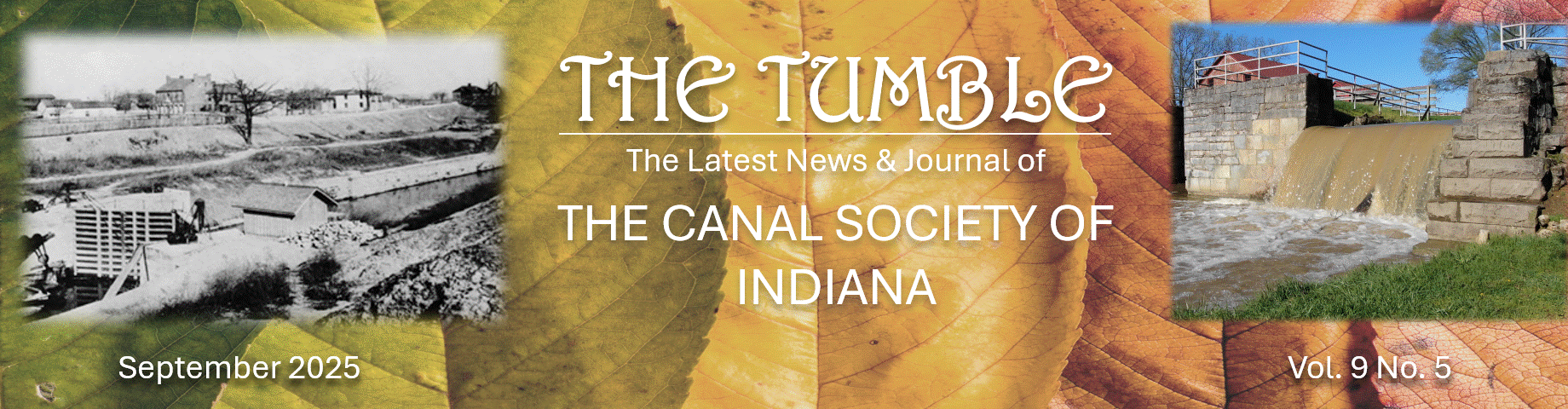
John Caldwell
Born: December 5, 1812
1844: Sought the U. S. Senate & House to give all unsold lands in the Vincennes district to Indiana to complete the Wabash & Ohio Canal
Died: August 7, 1879 (age 66)
Buried: Caldwell Cemetery, West Terre Haute, Vigo County, Indiana
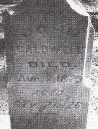
Thomas Jefferson Henley
Born: June 18, 1808 Richmond, Indiana
Attended: Indiana University
1828 Admitted to the bar, practiced in Richmond and also engaged in banking.
1832-1843 Member of the Indiana House of Representatives
1842-1843 27th Speaker of the Indiana House of Representatives
1843-1849 Member of the U. S. House of Representatives
1849 Moved to California and engaged in banking in Sacramento
1854-1859 Superintendent of Indiana Affairs for California
1860-1864 Postmaster of San Francisco
Died: May 1, 1875 Mendocino County, California
Buried: Valley View Cemetery, Covelo, California
THOMAS D. WALPOLE
Born: March 20, 1816 Zanesville, Ohio
1822 Moved to Indianapolis, Indiana
1834 Moved to Greenfield, Indiana
1836 Elected to Indiana legislature
1840 Elected to Indiana Senate
1842—1850 President of Indiana Senate
1860 Moved to Indianapolis
Died: 1863 Indianapolis
Buried: Crown Hill Cemetery, Indianapolis, Indiana
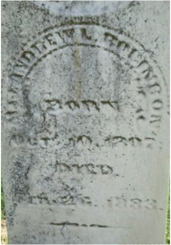
Andrew Lucas Robinson
Born: 1807, Vermont
Moved to Vanderburgh County, Indiana
1841-1844 Indiana House of Representative
1843-1844 Speaker of the Indiana House of Representatives
1850-1860 Attorney in Vanderburgh County
1852 Candidate for Governor — Free Soil Party (Joseph A Wright won)
1861 Customs surveyor of Vanderburgh County
Died: 1883
Buried: Oak Hill Cemetery, Evansville, Vanderburgh County, IN
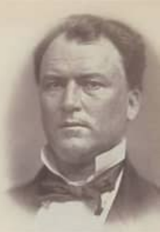
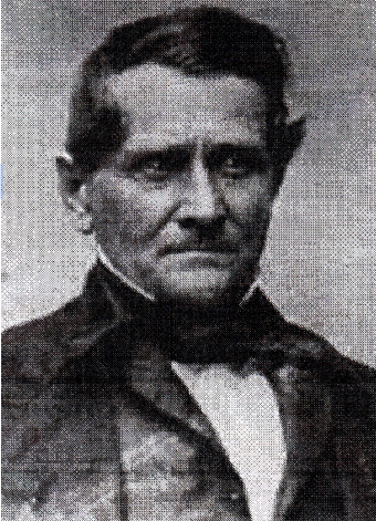
Jesse David Bright
Born: December 18, 1812 in Norwich, New York
1820 Moved to Madison, Indiana
1831 Admitted to the bar in 1831, practiced in Madison
1834 Elected judge of Jefferson County probate court
1840-1841 United States Marshal for the District of Indiana
1841-1843 Indiana State Senator
1843-1845 Indiana Lieutenant Governor
1845-1862 United States Senator from Indiana
(Expelled from Senate for supporting Jefferson Davis as President of the United States)
1853 Moved to Kentucky
1866 Kentucky House of Representatives
1871-1875 President of the Raymond City Coal Company
1874 Moved To Baltimore, Maryland
Died: May 20, 1875, Baltimore, Maryland
Buried: Green Mount Cemetery, Baltimore, Maryland
Land Purchases From Vincennes Grant
By Bob Schmidt
When CSI member Neil Sowards of Fort Wayne, Indiana was cleaning up to down size, he found the following material on land sales in Southern Indiana that occurred just after the 1845 Land Grant. An interesting note was attached as to where they came from. The note and documents were sent to Neil by Phil Sampley and said, “Neil—A businessman in Indianapolis bought a building that was empty except for desks and filing cabinets, along with boxes of these canal items. This took place around the late 1950s early 1960s.”
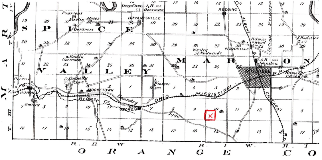
The first document is handwritten while the second is printed. Both seek preemption for land purchased. That means that the person having the preemptive rights has the option to buy a property before other offers may be recognized. Usually this means a land squatter, a “person occupying without legal title,” has the right to buy before other outside buyers. The first document dated September 10, 1847, was for an Alexander Burton of Lawrence County who wanted to purchase land near Mitchell Indiana. Note that the wording is very similar to the printed form of Daviess County where on September 6, 1847, David Benson was making a similar request. Due to the land description we were able to precisely locate and provide a map for the Lawrence County site. The Daviess County property lies in Range # 5 but the Congressional Township is unclear. We do know that Section 19 definitely lies along the 5 Townships that border Martin County to the east.
From Neil Sowards
State of Indiana, Lawrence County. Ss:
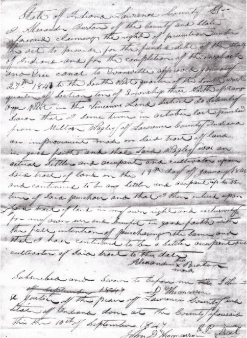
I Alexander Burton of the county and state aforesaid claiming the rights of preemption under the act to provide for the funded debt of the State of Indiana and for the completion of the Wabash and Erie canal to Evansville approved January 27th, 1847 to the South West quarter of the South West quarter of Section ten of Township three North of Range one West in the Vincennes Land district do solemnly swear that I some time in October last purchased from Milton Wagley of Lawrence County, Indiana an improvement made on said track of land in good faith and that said Wagley was an actual settler and occupant and cultivator upon said tract of land on the 19th day of January 1840 and continued to be a settler and occupant up to the time of said purchase and that I then entered upon this tract of land in my own rights and exclusively for my own use and benefit in good faith with the full intention of purchasing the same and that I have continued to be a settler occupant and cultivator of said tract to this date.
Subscribed and sworn to before me John D. Thomasson
A Justice of the Peace of Lawrence County, and State of Indiana done at the County aforesaid this the 10th of September 1847.
John D. Thomasson, J. P. (Seal)
A second printed document with lines filled in says:
State of Indiana, Daviess County, ss:
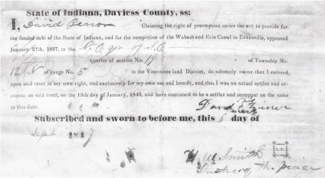
I, David Zirror Claiming the right of preemption under the act to provide for the funded debt of the State of Indiana, and for the completion of the Wabash and Erie Canal to Evansville, approved January 27th, 1847, to the N. E. qtr. of the S. E. quarter of section No. 19 of Township No. 12 N of range No. 5 in the Vincennes land District, do solemnly swear that I entered, upon said tract in my own right, and exclusively for my own and benefit, and that I was an actual settler and occupant on said tract, on the 19th day of January, 1846, and have continued to be a settler and occupant on the same to this date.
David (his X mark) Zirror
Subscribed and sworn to before me, this 6 day of Sept. 1847.
Will Smith L.S.
Justice of the Peace
Neil also obtained a copy from a friend of two pay vouchers that were prepared for partial work completed near Delphi in the summer of 1838. Both vouchers show the names of Steward & Hovey. One document in July for $171 is signed by the Engineer, A, David. The second voucher is dated Aug 28, 1838 for $155 and signed by J.B. Johnson as Acting Commissioner. They certify what is owed to the contractors.
From Neil Sowards
No. 1318 Delphi July 28, 1838
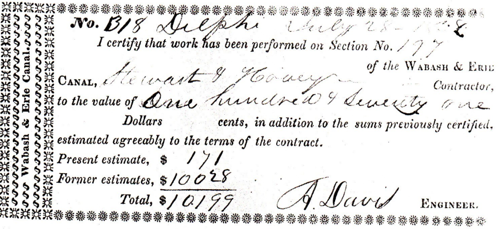
I certify that work has been preformed on Section No. 177 of the Wabash & Erie Canal, Stewart & Hovey Contractor, to the value of One hundred & Seventy-one Dollars ___ cents, in addition to the sum previously certified, estimated agreeably to the terms of the contract.
Present estimate, $ 171
Former estimates, $ 10028
Total, $ 10199
A. Davis Engineer.
WABASH & ERIE CANAL.
| $155 | Delphi | July 28, 1838 | No. 318 |
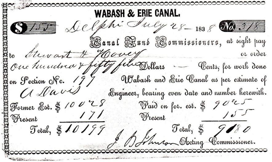
Canal And Commissioners, at sight pay to Stewart & Hovey or order one hundred & fifty five Dollars _____Cents, for work done on Section No. 197 Wabash and Erie Canal as per estimate of A Davis Engineer, bearing even date and number herewith.
| Former Est. | $ 10028 | Paid on for est. | $ 9025 | |
| Present | $ 171 | Present | $ 155 | |
| Total | $10199 | Total | $ 9180 |
J. D. Johnson Acting Commissioner.
By some research in our archives, I have identified the contractors as William Steward & L.D. Hovey. Some of their work details can be found in the Indiana State Archives in Indianapolis. The Engineer, A. David is unknown, but the Acting Commissioner was James B. Johnson of Tippecanoe County. Johnson replaced John Scott on the original Board of Commissioners whose term began on January 28, 1830. He continued on under the reorganized nine-man board created after the passing of the Internal Mammoth Improvement Act of 1836. Each of these commissioners assumed responsibilities for different areas of construction work throughout the state. James Johnson was responsible for the canal work between Georgetown and Lafayette. Johnson was born in 1796, died on March 4, 1849 and is buried in Greenbush Cemetery in Lafayette. See Find-A-Grave #57895620.
Canal Notes #21: Two Seasons
By Tom Castaldi
Even though the old Wabash & Erie Canal closed for business in the winter season, it possessed a unique spirit of giving. Throughout Indiana, winter brought low temperatures freezing free movement of water within its 40-feet width from towpath to berm bank.
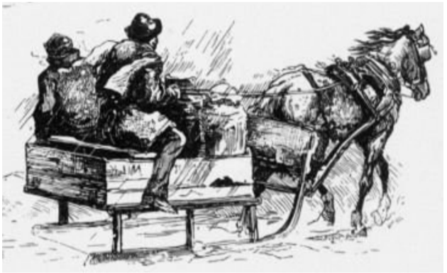
Each year the change of seasons transformed the canal into a solid sheet of shimmering ice, perfect for horse drawn sleigh travel through a winter wonderland. Surely it was a joy for all who were accustomed to slow, rough cart and wagon rides.
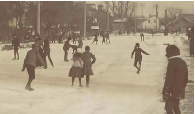
Ice skaters too could enjoy smooth surfaces for the fulfillment of their sport. An old illustration by Wils Berry depicts a frozen Eel River at Logansport, Indiana, providing an ice skater’s haven beneath the aqueduct on the Eel. Overhead a span of the frozen water-filled aqueduct trunk is graced with long icicles hanging low. Such scenes were no doubt repeated under the aqueduct at St. Mary’s river in Fort Wayne, on the wide turn basin at Delphi or on the landing at Huntington.
In Lafayette, blocks of ice were cut and removed from a place called Wide Water. Ice was stored under straw in warehouses for use in summer because no one had anything like a refrigerator.
Merchants were happy when the spring season thaw brought canal boats with goods from the east. Farmers welcomed its opening as the canal provided customers for their livestock and the crops they produced at harvest time. Everyone could look forward to the news stories of the world brought in by packet boat passengers and their discarded newspapers.
Winter and summer seasons limited the advantages of a canal, unlike the railroads that operated year ‘round.
As Indiana’s resources were opened up to the world, transportation systems were needed that had no season. Finally, open season was declared on the canal as rails and highways forced it out of existence for all time.
Canal Society Of Ohio Symposium At Piqua 2025
By Robert Schmidt, CSI treasurer
In celebration of the 200th Anniversary of the groundbreaking of Ohio’s Canals, a symposium was held at Piqua, Ohio on Saturday April 26, 2025. My wife, Carolyn, and I attended this event at the Piqua Public Library along with 25-30 others from Ohio. The beautiful library is located in the old 4 1⁄2 story Plaza Hotel, which opened there in 1892.
The symposium featured a series of four PowerPoint presentations on various aspects of Ohio’s canal system. It was followed by a walking tour to the nearby Miami & Erie Canal lock in Piqua.
David Neuhardt started off at 10:15 with “What the canals meant for Ohio”
Although Ohio became a state in 1803 she lacked adequate transportation to take her commodities to market and to bring other manufactured goods into the state. Although New Orleans was the primary destination for its agriculture products during the flat boat era, when the boats reached New Orleans they found an over supply of these products and lower prices. With the opening of the Erie Canal in 1825, Ohio wanted to reach the more lucrative eastern markets by creating a transportation system to Lake Erie and connect with the Erie Canal at Buffalo, New York. Ohio’s Governor Ethan Brown felt that canals were the answer to solve the state’s transportation dilemma. New York’s Governor Dewitt Clinton supported the plan and came for the Ohio & Erie Canal groundbreaking on July 4, 1825 at Newark, Ohio. Two weeks later on July 21, 1825 he was also at Middletown for their Miami Canal ceremony.
David had some excellent pictures of different types of canal boats and described some of the basic canal structures and how they functioned. One of the facts that he pointed out was that in 1836 Ohio passed a bill that expanded their canal system throughout the state. Interestingly 1836 was the same year that Indiana passed the Mammoth Internal Improvement Bill, which expanded our Hoosier transportation systems.
Kevin Coleman of Chillicothe was the next speaker – “Chillicothe: A canal town”
Kevin, a newspaper reporter, talked about Chillicothe’s hydraulic canal and told how the paper mill race from nearby Paint Creek was used by the mill and then became a feeder into the mainline Ohio and Erie Canal. The site was eventually purchased by the Mead Paper Company of Dayton, Ohio. Water power was produced by the fall of water from a higher to a lower level. This use at Chillicothe was an unusual arrangement because in most mill race operations water was taken from a canal near a lock and returned back into the same canal. Here the mill water actually became a source of additional water into the main canal. At many other sites in Indiana and Ohio water was sometimes drawn from the main canal, diverted through a mill race and then wasted into a nearby creek or river. The mills in Fort Wayne and Lafayette, Indiana are a good example of this type of mill race.
At lunch time we broke to eat at nearby restaurants of our choice.
Andy Hite resumed after lunch with his program “Ohio’s Other Canal – The Miami and Erie”
The original 1825 plan in Ohio was to build the Miami Canal from Dayton, Ohio to the Ohio River at Cincinnati. In 1832 work began to extend that canal from Dayton to the Laramie summit near Piqua. Then in 1836 the bill was passed expanding Ohio’s canal system by completing the Miami & Erie from Dayton to Junction, Ohio where it would meet up with the Wabash & Erie Canal that was underway from Toledo to the Indiana state line. This “Miami Extension” was completed in 1845 and on March 14, 1849 the name of the canal from Junction to Toledo was also officially changed from the Wabash & Erie Canal to the Miami & Erie Canal. That portion of the old Wabash & Erie Canal from Junction to the Ohio/Indiana State line retained the name Wabash & Erie Canal.
The summit of the Miami & Erie Canal was a 21-mile level that ran both south to the Lockington locks and north to New Bremen. The main feeder for this level was the Mercer Reservoir (Grand Lake St Mary’s). Also required was the construction of the Lewistown Reservoir, today’s Indian Lake. Water from the reservoirs was transferred to the summit level via both the St Mary’s and the Sidney feeders. Besides the obstacle of providing enough water to the canal, another obstacle for canal workers on this canal was the deep-cut at Spencerville. Here the canal was dug through a hill rather than having to build more canal prism for some distance around that elevation. All of these obstacles delayed the canal’s completion to Junction.
Steve Dorsten of Delphos – “Delphos a canal town”
For many years Steve worked for Ohio DNR and was responsible for the water uses and maintenance of the Miami & Erie Canal from New Bremen to Grand Lake St Mary’s and then north to Delphos. He worked with local communities along the route to develop recreational use of the old canal. He was instrumental in the development of trails and in repairing canal structures. His Saturday PowerPoint program described the progress that has been made over the years and his continued work after retirement to expand the canal trails from Delphos south into the St Mary’s area. He showed the funding costs and how community canal interest has greatly increased in recent years, especially with the rebuild of Lock No. 1 North at New Bremen, which is the Headquarters for MECCA, The Miami and Erie Canal Corridor Association. This is just one of the groups working with Steve along the canal route in Ohio. He willingly shared his planning process with other towns and counties.
CSI members attending the symposium: Mike Morthorst, Bob & Carolyn Schmidt
Outreach Events & Programs

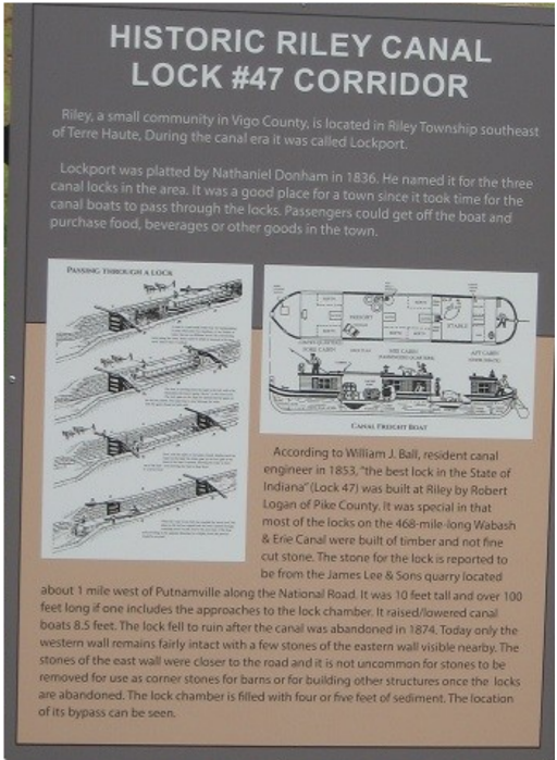
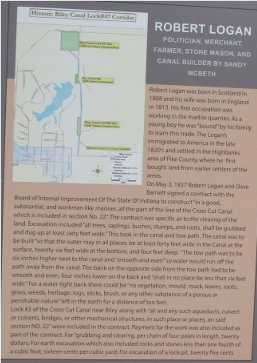
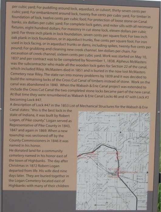
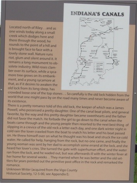
4-Panel Sign Placed At Riley Lock
By Sam Ligget, CSI vice-president, text and photos
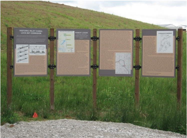
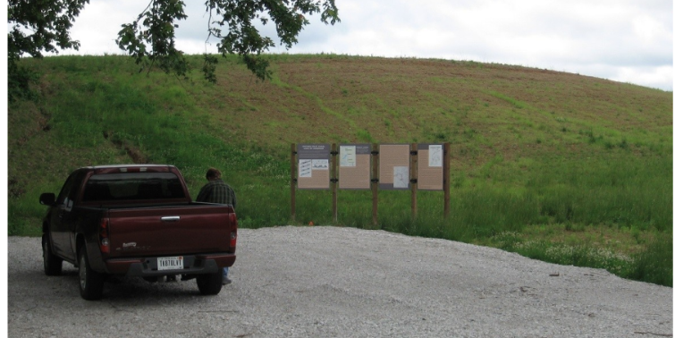
As reported earlier this year, the Vigo County Parks & Recreation Department built a parking area at the north end of the property that is being developed as a park for the remnants of Lock # 47 on the Wabash & Erie Canal. On May 21, 2025, Jeff Koehler, CSI director, called to inform us that he had driven by the parking lot and was surprised to see that a new 4-panel sign about the canal had been erected at this lot. Jeff said the sign was very well done. My wife, Jo, and I visited the location, and indeed there is a high-quality sign. It contains information about the canal lock and how it works. There are also facts about Robert Logan. The trail from the parking lot to the lock has yet to be constructed.
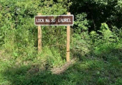
CSI Sign Placed at Laurel Lock #30 Whitewater Canal
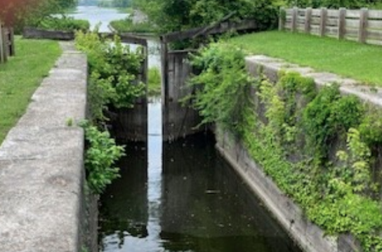
CSI thanks Shirley Lamb for notifying us that Whitewater Canal Trails has placed our sign at Lock No. 30 along the road to the Whitewater Canal Feeder Dam near Laurel, Indiana. We really appreciate the help of other groups like this in erecting the signs. The lock is in the dark area behind the sign.
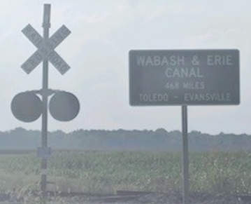
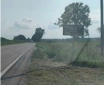
Two Signs Placed at Elnora For W & E Canal

Troy Jones, CSI member from Clinton, Indiana reports that two CSI signs for the Wabash & Erie Canal have been put up in Elnora, Indiana. Troy got permission from the Elnora Township City Hall to have two CSI signs made. When he delivered them to the City Superintendent, they were so busy at that time that the signs did not get erected. About a year and a half later he contacted them again asking Deanna Collison, Elnora’s Clerk-Treasurer, if they still had the signs. She said that when she accepted the position in 2024 she had found them stored in an old bank vault and had them on hand. She said she would contact INDOT and ask them to install the signs. She said she started at the top and called the Secretary-Treasurer of Indiana, who called INDOT, and asked them to erect the signs with the understanding that Elnora Townships’ Cit Hall agreed to keep the area mowed around the signs.
Troy learned a few days later that the two signs are now up along State Highway 57. The first is at the corner of State Highways 57 and 58 by the railroad signal. The second one is about 1 mile south of Elnora on State Highway 57. You will notice that Troy took the following photos of the signs late in the day. He said they did a great job and the grass is nicely cut around the signs.
The Canal Society of Indiana thanks Troy, Deanna Collison, the Secretary-Treasurer of Indiana, and INDOT for working together in posting these signs.

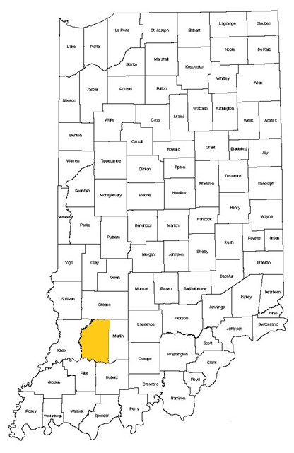
Daviess County, Indiana
Elnora population 631 in
2020
Speakers Bureau
Terre Haute, Indiana
Sam Ligget, CSI Director from Terre Haute, Indiana, presented his PowerPoint program on the nadir level of the Wabash & Erie Canal to about 20 members of the Terre Haute Kiwanis Club at the MCL Cafeteria’s meeting room on June 19, 2025. They were an attentive bunch and had a number of good questions and comments.

Worthington, Indiana
Jeff Koehler, CSI Director from Center Point, Indiana, gave a presentation about the Wabash & Erie Canal at the Worthington Jefferson Township Library, 26 N. Commercial Street, Worthington, Indiana on August 12, 2025, at 6:00 P.M. There were 37 present.

News From Delphi
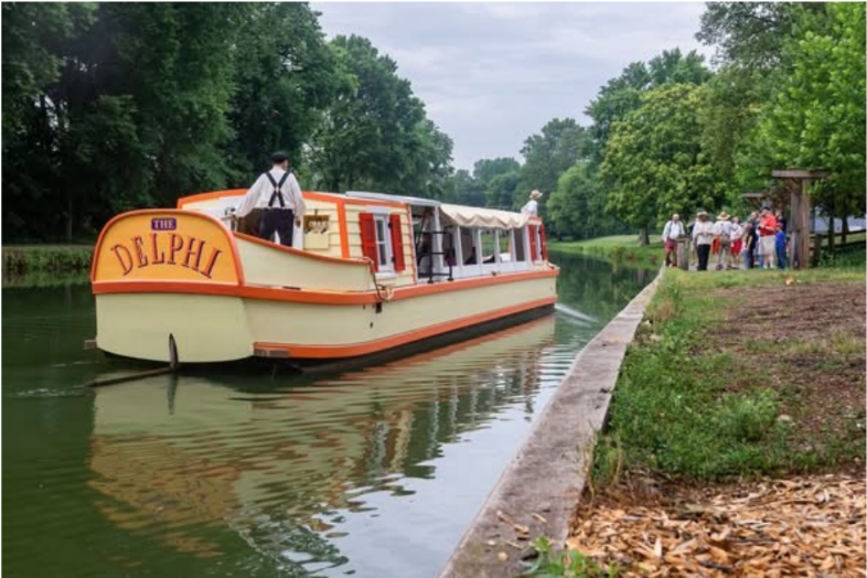
Saturday in the Park
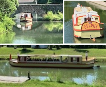
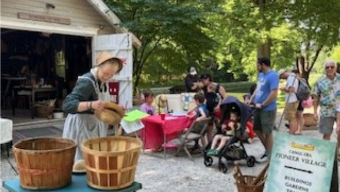
Carroll County Wabash & Erie Canal Association began its Saturday programs at the Wabash & Erie Canal Park in Delphi on May 24 from 1-4 PM with fun for all ages as they learned about America’s longest canal. These programs included rides on the “Delphi,” a replica canal boat at 1:30 and 2:30, tours of the historic Reed Case House, exploration of the 1850 Pioneer Village and its historic trades shops and activities, seeing the interactive Canal Museum, playing on the canal boat playground, taking a narrated nature walk at 2:30 and hiking the miles of trails. Many of these activities were free:

“Canal Days” July 5
Text by Carolyn Schmidt, Photos by Bob Schmidt
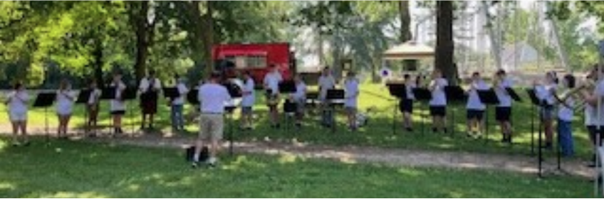
Canal Park in Delphi was open from 10 a.m. to 4 p.m. on Saturday, July 5, 2025 to celebrate “Canal Days.” Canal era music filled the air all day and a special band concert at 11 a.m. welcomed visitors to the park just after the town’s parade ended.
My husband, Bob, and I arrived as the band started playing and headed straight to the Canal Interpretive Center to purchase tickets for the canal boat ride aboard “The Delphi.” We had been warned that the boat ride was the highlight of the day and should purchase tickets ahead of time. The first available ride was at 2:30 p.m. We were guaranteed that there was a lot to do in the meantime.
Having attended many “Canal Days” over the years, we knew that the next place we had to go was the Snack Shack, operated by the members of the Carroll County Wabash & Erie Canal Association with profits going to the park. Their homemade pies are wonderful and, we knew that if we wanted our favorites, we had to act quickly before they were sold out. Skilled pie bakers are becoming harder and harder to find.
Frances “Francie” French, CSI member from Lafayette and previously Delphi, has been baking pies for this event longer than she can remember. She is 96 years old and lives in her own home. We found her in the Interpretive Center busy handing out maps to the park, enjoying the air conditioning, and resting after baking rhubarb pies for the event. She said years ago there were lots of volunteers helping bake the pies, but now it was just her daughter Marlene and her granddaughter, who baked all the many other choices of fruit pies. The pies were sold whole or by the slice.

Francie and her husband, Jim French, were very instrumental in getting Canal Park going in its early years. Jim was president of the organization during that time. He later worked at Canal Days helping children make bird houses while Francie baked pies and worked in the Snack Shack. Jim served on the Canal Society of Indiana’s board of directors from 1991-1993. They were both on the Canal Society of Indiana’s Advisory Council.
The event room at the Interpretive Center had a video about the Wabash & Erie Canal in Lafayette that had been written and previously presented at Lafayette by Mike Tetrault, Executive Director of Carroll County Wabash & Erie Canal. Mike was hired in October 2021 to head up this Carroll County volunteer organization. This program ran in a loop. Seating was set up for those who watched it while cooling off from the outside heat.
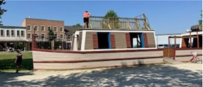
Although temperatures kept rising, the buildings in the Pioneer Village and the vendors in the park were shaded by trees and a cool breeze helped keep visitors comfortable. Children enjoyed climbing on the stationary canal boat playground and participating in crafts and other organized activities for them.
A new ride this year could be taken on a wagon pulled by mules. It took visitors along the canal to the back of the park and returned to the visitors’ center. Unfortunately our photos of this ride were too dark. Vendors of everything from fancy pens to huge crocheted coverlets, jewelry to homemade paper, homemade lemonade to bottled drinks, robots to birdhouses, face creams to specialized teas, etc. were set up throughout the park. Bird houses could be built with a requested donation. An organ grinder demonstrated a new organ he had just put together this past year. A rusted car like those to used to go West was on display. The Reed Case House and the Canal Museum were open with tours.
With all that was happening this day, it seemed like Chicago’s 1972 song, “Saturday in the Park” was written about it.
“Saturday in the park
I think it was the 4th of July
People dancing, people laughing
A man selling ice cream…”
“…Can you dig it? Yes, I can.
We dig the Carroll County Wabash & Erie Canal Park!
A Visit to the Illinois & Michigan Canal
By Carolyn Schmidt, Photos by Bob Schmidt
In 1827 the states of Indiana, Illinois, and Ohio all received land grants from the federal government to fund their canals. Ohio opened the Miami Canal in 1829 to Dayton and by 1845 it reached Junction, Ohio to join the Wabash & Erie Canal. Indiana opened the W& E Canal from Fort Wayne to Huntington in 1835, was completed between Lafayette and Toledo, Ohio by 1843, and reached Evansville, Indiana in October 1853.
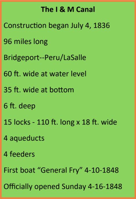
Constructed by Irish, German and Scandinavian immigrants and supported by notables such as Abraham Lincoln, the opening of the Illinois & Michigan Canal (I&M Canal) on Monday, April 10, 1848, was the culmination of the vision—to make northern Illinois and Chicago an American crossroads that was held by Illinois’ citizens for over 200 years. Their enthusiasm and high hopes for the future were captured in the following news articles from the Ottawa Free Trader, Ottawa, Illinois, Friday, April 14, 1848, page 2:
Canal Open:
The sparkling lakes of the north and the father of waters have kissed, embraced, and are united! The nuptials took place at Chicago last Monday. They were celebrated by the firing of a hundred guns, and joyous acclamations of ten thousand citizens. It was a bright and glorious day for Illinois. This great object, which was the dream of her infancy, the struggle of her youth, and will be the pride and boast of her manhood, is, at length, after years of toil, difficulty, and tribulation, accomplished. The canal is open, the first boat has floated upon its waters, and, in a few days more, the boatman’s horn will be a familiar sound to our ears. How long have we scheduled to announce this joyful event! How important—how cheering for Illinois will be the consequences!
Canal Celebration.
We suggest whether it is not time for our people to meet and Illinois &Michigan Canal Prism at Morris, Illinois “The Volunteer” 70-passenger boat at LaSalle, Illinois appoint suitable committees to confer with similar committees from other places on the line of the canal, in reference to the proposed general celebration of the event of the opening of the canal. The committees from above will be down on the first packet, which we presume may be looked for here during the coming week, and as there is a general disposition in the community to take a part in this celebration, our committee should be appointed without delay. It has been suggested to have the celebration on or about the fourth of July; and to meet the Governor and other State officers at Peru a day or two previous to the 4th, and escort them to Chicago where the celebration is to take place, the people on the line joining in as they pass us. This is thrown out, however, merely for the consideration of the various committees, when, of course, will make such arrangements as they may consider most expedient.
“In total the canal operated for 67 years and shipped 74 million tons of freight—a remarkable feat for an obsolete technology—the Illinois and Michigan Canal served a useful purpose for far longer than could have been expected.” Larry Natta
The I&M Canal experienced the same problems other canals faced especially with competition from railroads. By 1853 railroad tracks paralleled the canal route. The canal lowered its tolls in an effort to compete with the railroad. Then later in 1933 the Illinois Waterway (the canalized Illinois River) opened adjacent to the canal thus ending shipping by canal. The I&M was officially closed to commerce that year. It was almost idle for the next 70 years.
During its 67 years of service, the port of Chicago grew as expected and the small towns along the waterway also grew in population. In 1830 the population north of Peoria was only 1310 and by 1850 was 125,708 most of which was in Chicago.
In 1964 the bed and right-of-way of the I&M were taken over by the highways from Chicago to Summit.
Congress finally recognized the importance of the I&M in 1984 when it designated the canal as the country’s first National Heritage Area. It is not federal land. It is a park along a corridor comprised of 60 cities and towns, from Chicago to LaSalle-Peru, who owe their growth to the canal. The Canal Corridor Association serves as its coordinating entity. It interprets the history of the corridor and its significance in the settlement and growth of not only the region, but of the nation. The canal continues to provide transportation in some areas and recreation.
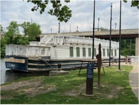
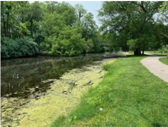
Today, although the displays, exhibits, and signage that were erected by the communities along the I&M Canal are showing signs of aging, they have been kept up pretty well by these communities and offer the visitor lots of information; picture taking opportunities of old canal locks, murals and silhouettes; museums; great restaurants; shopping; and other activities. The canal itself is not nearly as navigable as it was when the corridor opened. Trees and vegetation along its route have not been removed in many areas. However, LaSalle, which offers rides on “The Volunteer,” a full-size canal boat replica, does an outstanding job of clearing the canal of debris and overhanging branches.
Some examples of places to visit from Morris to LaSalle/Peru are:
Morris, Illinois has Canalport Plaza, which sports eight life-size silhouettes and panels that tell the story of the Armstrong family, some of the earliest settlers.
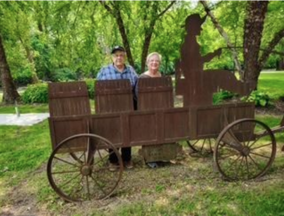
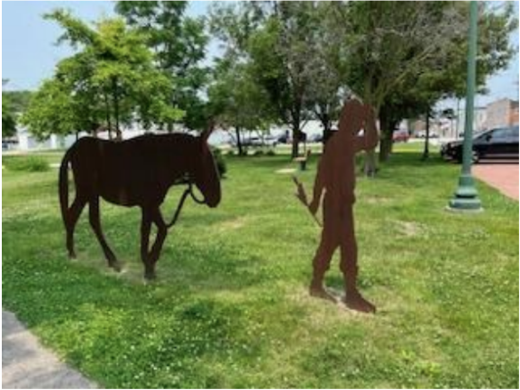
One block away is Canalport Park, which features a full size, wooden canal boat on which children may play; steel silhouettes of a mule and canal driver. They tell the story of Old Nell, the most famous mule on the towpath, and a canal driver, John Sullivan. There is also a canal mural.
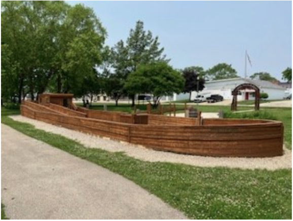
Another block away is the Grundy County Historical Society with a great diorama of an aqueduct, canal boat basin, and lock. It also has art about the canal and other local history.
Seneca, Illinois has the M. J. Hogan Grain Elevator where grain was loaded onto canal boats.
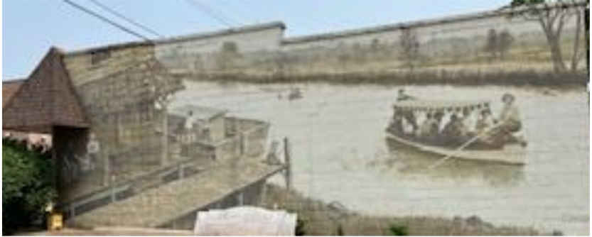
Ottawa, Illinois has the Ottawa Toll House; the Fox River Aqueduct, which carried the I&M Canal over the Fox River (464-ft. long); the Reddick Mansion, home of William Reddick, a county sheriff, state senator and founder of the local glass industry; a bronze monument of Abraham Lincoln and Stephen A. Douglas, who held their first of six political debates on Washington Square on August 21, 1858; and the Ottawa Historical and Scouting Heritage Museum.
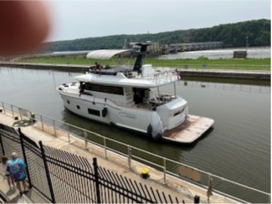
Utica, Illinois is where I&M Canal workers discovered a vein of limestone. It made good cement and was used to construct the canal’s locks. There an 1840s canal warehouse is home to the LaSalle County Historical Society’s museum, which has canal related exhibits. It also has the Starved Rock Country Welcome Center, which has a wonderful Illinois-made gift shop, free maps and guides, and local experts to plan your tour. Many restaurants, taverns, and shops attract visitors to the area. Nearby is the Illinois Waterway Visitor Center where visitors can overlook Starved Rock Lock and Dam and watch rafts of barges or beautiful yachts pass through the locks on the Illinois River. On the opposite side of the river is Starved Rock Park and Inn.
Lasalle, Illinois was at the I&M Canal’s western terminus where the canal boats transferred their products to steamboats on the Illinois River. Finished products from the east came down the canal for the west, products from the south came north, raw materials from the Midwest went into Chicago or onto eastern markets. It was an economic crossroads Lock 16 Visitor Center, which once housed a horse buggy maker, was restored in 1910 and has beautiful murals on its walls, offers brochures to canal sites and other venues, sells tickets for canal boat rides on “The Volunteer,” and has a café and gift shop. At Lock 14, just a short way below the center and entered on the other side of the canal, are the only restored gates on the canal. Just upstream from the lock is “The Volunteer” canal boat where period-dressed guides tell the stories of the I&M canal as well as give visitors a chance to learn more about mules. Usually underwater is Lock 15, the last lock before the canal enters the Illinois river. Around the parking lot for “The Volunteer” and locks are 13 steel silhouettes that depict canal workers and boat passengers.
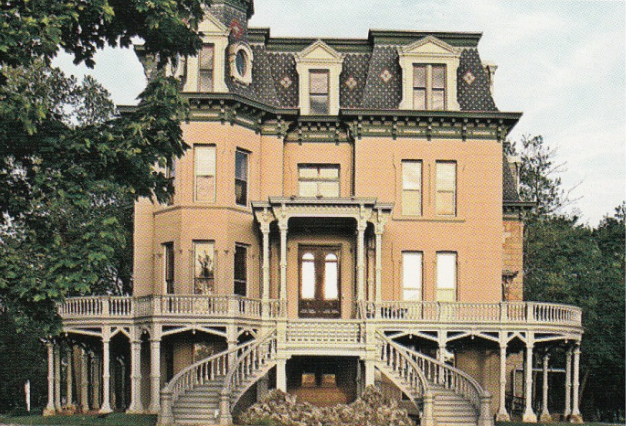
LaSalle is also home to the 16,000-square-foot, seven-level Hegeler Carus Mansion, home of zinc manufacturers, who founded Open Court Publishing Company. It published philosophical journals and books. It was the first company to translate major Buddhist texts. Visitors to the mansion see a virtually unchanged interior since the 19th century.
Peru, Illinois is just downriver from LaSalle. When the Canal Commissioners were selecting the terminus of the I&M Canal, Peru and LaSalle competed for it. The commissioners chose LaSalle because they controlled the land there. Traffic from the canal and abundant coal mines eventually made Peru prosperous.
For further information and pictures of this portion of the I&M see the article “June At The I&M Canal” in the September 2024 issue of “The Tumble.”
Canal Society of Indiana
News and Programs
Members’ Milestones

On June 9, 2025, Bob and Carolyn Schmidt and Sue Jesse visited Gerry at his retirement center. Although his legs aren’t cooperating, they found him in a wheelchair, very alert and reminisced about the canal tours of the Illinois & Michigan Canal (1996, 2009, & 2017) and the Hennepin Canal (2012), which he was instrumental in setting up for CSI. We talked in length about his family, the various jobs he had held, his Honor Flight, his work at the LaSalle County Historical Society Museum in Utica, the lantern tours he once led, and his participation in various canal projects. Later when the Schmidt’s visited the library in Morris, Illinois for canal research, they found many clippings and interviews with Gerry about the part he played in restoring the Fox River Aqueduct, and his relating the history of the canal to others.
Gerald Hulslander, CSI member from Ottawa, Illinois, celebrated his 100th birthday on Sunday, August 10 from 2-4 p.m. at an open house given by his children at Trinity Lutheran Church, in Ottawa, Illinois. Gerry is widely known by the farmers and landowners along the I&M Canal, many of whom came to his party and were served coffee, lemonade and cookies. His actual birthday was 2 days later on Tuesday August 12th. Those who were unable to attend were asked to send cards to his residence center in Ottawa. His address is 505 College Avenue Room 410, Ottawa, IL, 61350.
Gerry and his wife, Jean, attended many CSI tours. Jean was an avid quilter and was in charge of refolding the many quilts housed at the LaSalle CHS Museum in Utica to keep them from developing deep creases. She was also in charge of making the Illinois bi-centennial quilt (2018) that is on display at the Starved Rock Country Welcome Center.
Welcome New Members
Marcia Laswell Yates of Winslow, IN
Contributions To CSI
Gary Seibert of Ft. Branch, IN for $20
Upcoming CSI Events
October 24, 2025 CSI “Side-cut Canals” Symposium And Sign Dedication
The CSI “Side-cut Canals” Symposium and Dedication of the Wabash & Erie Canal, Williamsport Dock, 1852 Side-Cut sign will be held at the Warren County Learning Center, 26 E. Second Street, Williamsport, Indiana from 10:30 a.m. to 4:00 p.m. on Friday, October 24, 2025. Bring a sack lunch.
November 15, 2025 CSI Board Of Directors Meeting
The annual CSI Board of Directors meeting will be held Saturday November 15, 2025, from 10:30 a.m. to 3 p.m. at the Vigo County Historical Museum, 929 Wabash Avenue, Terre Haute, Indiana.