
In this edition of

Side-cut Canals
Robert F. Schmidt
Throughout history canals were built for 3 major reasons. Probably the first was to direct water sources for crop growing or other basic human needs. In the next phase of development, canals were used as a power source turning a grinding wheel for processing grains and later for other mechanical uses such as sawing lumber. Finally, canals were used to transport goods, livestock, people, and mail (or other types of earlier communications).
When constructing a canal, earth and other obstacles needed to be removed along the route so that the canal would be a gentle sloping waterway. The water needed to flow from higher elevations to lower levels, but not so fast that it would erode the earthen banks of the canal. Another consideration was to build the canal in as straight of a line as possible to reduce the amount of earth that needed to be removed and prevent bank erosion by a meandering route. Finally, the canal needed to connect as many human settlements as possible without violating some of the considerations above.
When constructing a canal, earth and other obstacles needed to be removed along the route so that the canal would be a gentle sloping waterway. The water needed to flow from higher elevations to lower levels, but not so fast that it would erode the earthen banks of the canal. Another consideration was to build the canal in as straight of a line as possible to reduce the amount of earth that needed to be removed and prevent bank erosion by a meandering route. Finally, the canal needed to connect as many human settlements as possible without violating some of the considerations above.
A canal of any great distance soon faced another obstacle as the change in land elevation worked against the need to maintain a gradual change in the canal level. Even ancient canal builders quickly learned that land elevation changes would only allow a limited distance to keep the canal at a reasonable level. The canal lock was invented by Leonardo da Vinci to solve this problem. A lock acted as a stopper in the canal that could be manipulated to move a boat between levels.
When the canal reached a river or steam canal builders faced another challenge—how to get across it. They could carry their boats down to the lower river level, pole across the river, carry their boat up to the canal level on the other side and resume their travel. Later, as boats got larger and heavier, they built aqueducts over rivers or culverts across smaller streams to carry the canal above these obstacles.
Another major consideration was the water supply. The dimensions of all canals are limited by the availability of water that can be obtained at the various sources along their route. There were many communities that wanted to be on a canal, but faced the limiting factors of distance and water supply.
Communities that were bypassed by a canal had to decide what they would do. They could accept the fact that the canal would not reach them and, if they wanted to use the canal, they would have to carry goods by wagon or on foot to the nearest canal location. If the distance was too far from the canal, they could organize their own canal company and dig a lateral or side-cut canal from their place to the mainline canal. (One of the best known examples of this situation in Indiana was the Hagerstown Canal. It was an eight-mile-long, privately financed canal between Hagerstown and Cambridge City where it connected with the Whitewater Canal. It was more of an extension than a side-cut or lateral canal.)
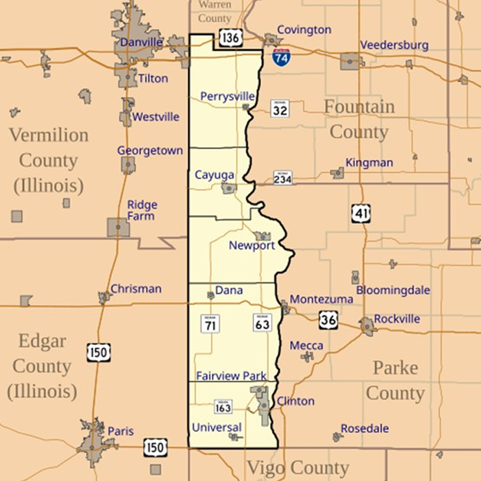
The Wabash & Erie Canal ran along the east side of the Wabash River from Lafayette to Terre Haute. There were considerable farmlands in Indiana and Illinois on the west side of the Wabash River that needed a transportation outlet. Some of this need was fulfilled by steamboats that could arrive in the Spring, but water levels in the Summer and late Fall were often too low for river navigation. Access to the Wabash & Erie was very desirable. West of the river from Lafayette to Terre Haute there were four towns: Independence, Williamsport, Perrysville and Clinton.
Note: Indiana spells Vermillion with 2- Ls – French version vs. Illinois uses only 1 -L
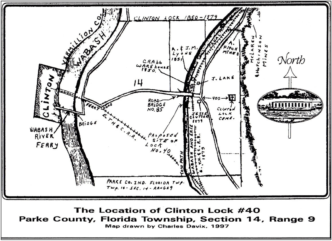
Clinton, Indiana, chose not to build a side-cut canal but to utilize the ferry to cross the Wabash and follow the existing ferry road to Hudnut (Lyford) where John Crab had built a warehouse beside the mainline canal. Here the canal boats could be loaded and unloaded. To the south of Crabb’s warehouse was Lock No. 40 that was appropriately called Clinton Locks.
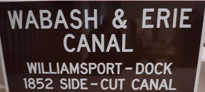
On the Wabash & Erie Canal there were two side-cuts completed, both that were originally authorized in 1843 by the Indiana General Assembly—Perrysville in Vermillion County and Williamsport in Warren County. Independence in Warren County, seven miles north of Williamsport, was too lightly populated and no side-cut was ever attempted.
The Perrysville Canal Lock Company was chartered in 1843. The construction of this canal was done in 1845-46 before the Wabash & Erie reached beyond Lodi, so by 1849 when the Wabash & Erie reached Terre Haute, the Perrysville side-cut was fully operational. Boats were poled across the Wabash River into a 1-mile-long canal channel and then lifted by a lock into the main canal.
In the Chief Engineers report of 1848, it was noted that the Wabash & Erie was watered to Coal Creek (Lodi) but that the water supply south of Lafayette was not sufficient. Boats carrying grain could only operate at 1/2 to 2/3 of a normal capacity during the summer months. The dams at Pittsburgh and Wea Creek were each raised 1 foot to increase the water supply. How did this water supply insufficiency develop?
Placing a feeder dam on the Wabash River south of Lafayette was not considered feasible as there already was steamboat traffic to that point and a dam would hamper traffic. Also the wide flood plain of the Wabash south of Lafayette made building a dam more difficult. A steamboat lock had already been built at Pittsburgh, but it became unnecessary as steamboats could not pass further up the Wabash. Dams built across the upper Wabash were fine since there wasn’t any steamboat or flat boat traffic.
In 1840 the Wabash & Erie reached Lafayette. At that time there was plenty of water coming from the Delphi / Pittsburgh Dam so the Trustees offered water leases for the construction of mills in the town rather than just waste the water into the Wabash. Remember the canal flowed into town and had to be allowed to be directed somewhere.
For the next six years, due to the Indiana’s financial crisis, construction was slowed south of Lafayette and the canal wasn’t completely watered to Lodi until 1847. Now there wasn’t enough water supply and the canal Trustees did not want to shut down the Lafayette mills that still relied on the water to turn the mill wheels. The creeks south of Lafayette proved insufficient for this purpose until the canal reached Sugar Creek. The Perrysville Lock had been poorly constructed and leaked as much water as was being added by raising the Pittsburgh and Wea dams. In order to keep the main canal operating, the Trustees had to oppose side-cuts that wasted water despite the need for more boat traffic from the west side of the Wabash.
Although the Williamsport side-cut had been authorized by the Legislature in 1843, the town members hadn’t really pursued this effort for several years. On May 25, 1850, William R Boyer*, the Secretary of the Williamsport Canal Lock Company, wrote a letter to the Trustees of the Wabash & Erie Canal requesting financial aid in their effort to construct a side-cut. With 150 stockholders, they had raised about $15,000 to build the lock and side-cut. Illinois farmers as far as 20 miles away supported this effort.
Resident Engineer, Thomas Dowling replied to Boyer’s letter on June 8, 1850, for the Board stating: “You are therefore hereby notified, that we shall resist any attempt on your part to divert any water from the Canal for the purpose of supplying your side-cut, as it will seriously affect the navigation on the main-line canal.”
Despite this discouraging reply, the folks of Williamsport proceeded to dig the side-cut and lock, which was completed by 1852. The town was incorporated in March 1854 with a population of 552. This side-cut operated for just a couple of years as the railroad crossed the Wabash River from the east and then arrived in Williamsport in 1856. The railroad provided a permanent year-round outlet for their agricultural products. The so called “Old Town” at the river now shifted to “New Town” up the bluff beside the new railroad. Today the town’s total population is only 1,950 and Warren County has a very small population of 8,440.
In 2025 the Canal Society of Indiana recognized the efforts of Williamsport to access the Wabash & Erie Canal by placing a sign in Old Town Park along the banks of the Wabash River.
*Besides being the Secretary of the Williamsport Canal Lock Company, William R. Boyer was the Clerk for the Associate Judge of Warren County (June 22, 1841), later the Judge of the Common Pleas Court, and when his brother Dr. Conrad Richards Boyer became ill William insisted he move to Indiana instead of going to South America. After William died Conrad and his sister contributed $125.00 for the large double window in the front of the new Williamsport Presbyterian Church in memory of William.
Ice Is Nice
Carolyn I. Schmidt
Those of you who have been to a restaurant in a foreign country, ordered a carbonated beverage and received it at room temperature probably agree with me that “ice is a nice” addition to the beverages we enjoy in the United States. We are spoiled by having ice at our fingertips in our home refrigerators. This has not always been the case.
Early settlers hung food and drink in their wells to keep them cool and from perishing. If the winters were cold enough they cut ice from nearby frozen ponds or lakes and stored it in ice cellars underground. This ice didn’t last very long. It sat in the water that melted from it, which caused it to melt even faster. The more wealthy people like George Washington had ice houses with drainage built outside their homes.
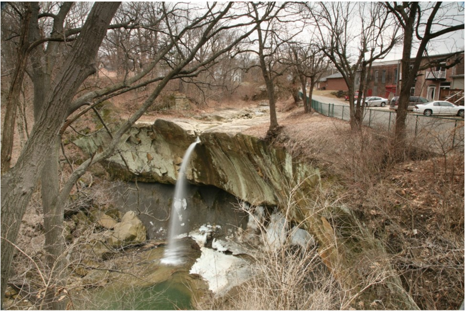
During the canal era in Indiana (1832-1872) ice ponds were built near our canals that filled them with water, which froze and could be cut into ice blocks. One of these old ponds was along US Route 52 and the Whitewater Canal Trail south east of Brookville. In the 1800s ice was harvested from this low-lying, flatbottomed area known as Hendrickson Ice Pond. Some ice pond owners stored their ice in ice houses and used the ice locally, but more was taken to Cincinnati for use by the breweries.
South End of Brookville
Canal basins also froze over and ice was cut from them. The Canal Basin at Brookville was noted as being a great place to harvest ice most years. It even had an ice house, which was at that time located to the far right of this picture.
Site Plan of Old Ice House Near Metamora
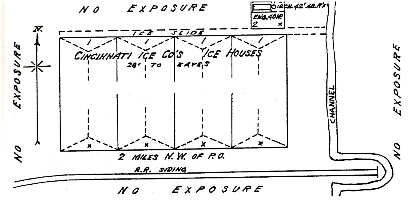
This site plan shows a large ice house that was located on the Whitewater Canal half-way between Metamora and Laurel, Indiana. It was of frame construction and the double walled building was insulated with sawdust. Note that it says Cincinnati Ice Co’s Ice Houses. This company had many ice houses along the canal and sold most of its ice in Cincinnati.
South End of Brookville
Men would score the ice in the Brookville Basin in two-foot intervals and sawed it into sixteen-inch blocks. The blocks were floated to the ice house where they were stacked to make a cake of ice ten inches in thickness. The block measuring 16 x 24 x 10 inches weighed 100 pounds. It was then slid up a ramp into the ice house and packed in layers of sawdust.
During the summer months this ice sold for three to five cents per pound.
Helen Gordon reminisced:
“The ice house that I remember
was up on the head of the [Whitewater] canal, right
above the handle factory. And it had thirty two chambers
to it. And they used to cut ice on the ice pond and put it in
these chambers, and it would keep there for all summer.“People would go there and get ice to use, And, oh I don’t
know [the date] they had this so full of ice one time. all
thirty-two chambers were just full of ice. And it burnt that
night. Somebody set it afire and it burnt. And after it
burned down there was all that ice all stacked up. It stayed
for a long time to melt. People used to come there and get
ice.”
In 1908 ice was scored, cut and stored in a newer Brookville Basin ice house.
In the ice house the workers would pile the ice blocks into layers that were separated by sawdust or straw from the bottom to the top. The ice house had better drainage that the underground cellars and the ice lasted longer. Later, during warm weather, the ice was removed from the ice house as needed. In order to keep the ice house cold, they had to work quickly when removing ice from the building.
To harvest the ice, the snow was scraped off the top of it, the ice was measured and marked into blocks, then cut into floats using special saws, and the floats were pushed by pike poles through a channel to the ice house or pulled there by a horse. Larger river ice cutting operations in the northeastern states actually had conveyor belts, which were powered by steam engines that carried the blocks of ice up to the different levels in the ice house.
The ice crop from the ice ponds and canal basins was not as pure as the ice frozen and harvested from the clear, clean, cold rivers and lakes of the New England states. But the ice was not put directly into food or beverages. Instead most homes had an insulated ice box. It was loaded with a block of ice in one compartment and the perishable food was placed in another compartment. Later, fancier two-sided ice boxes were made.
Almost daily icemen made deliveries by a horsepulled ice wagon to replace the melting ice block. The homeowner would place a sign in the window for how many pounds of ice he wanted to be delivered. The iceman would cut the ice to the correct size and take it to the house. This practice of ice delivery extended into the early twentieth century. My, Carolyn Schmidt, husband’s parents still used an icebox in 1937 when they were married.
Today pure ice, which can be put directly into our food or beverages, is produced by our refrigerators or by ice plants, which sell larger quantities of bagged ice. “Ice is Nice.”
Sylvan Lake Ice Harvest
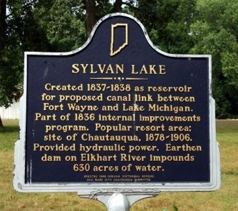
Of the 110 miles of the Erie & Michigan Canal that was authorized by Indiana’s 1836 Internal Improvement Bill, only the Northport Feeder Reservoir (Sylvan Lake), which covered 630 acres of land, and 7 miles of the canal were ever built. However, this reservoir was later used to harvest ice. The January 19, 1882 issue of the Fort Wayne Daily News reported:
“The ice harvest at Rome City began to-day. Seven inches in the thickness of the cakes. Shipments to Columbus, O., and St. Louis, Mo. have already been made. Twenty [rail] carloads will be put up daily.”
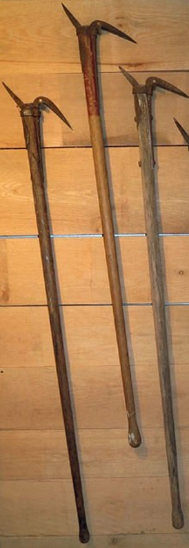
Ice Cutting Tools
Including horse-drawn implements, as many as 60 different tools were used in the 1800s to harvest ice. Hand-held crosscut ice saws measuring more than 5 feet in length and breaking bars were commonly used to finish cutting or breaking blocks of ice loose. Shown here are a few of the more commonly used tools.
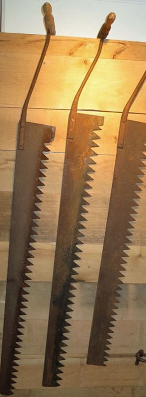
Ice Saws
A pond ice saw is very long because it needs to cut through ice that might be 18 inches thick. A good ice cutter would pull the saw almost out of the ice then lean far over to push the saw handles almost to the surface of the pond.
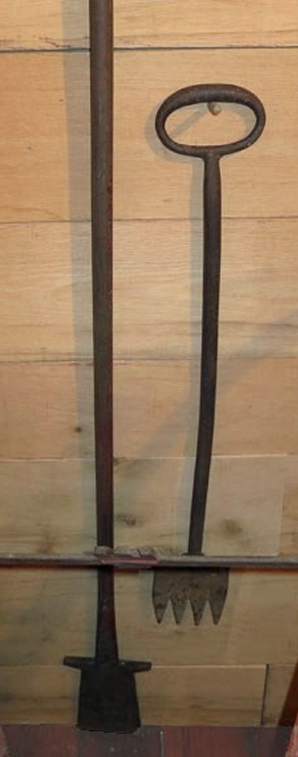
Chisels
The men with the saws did not need to cut out each individual ice block. It was often faster to cut out a line of several ice blocks, then have a man with a heavy chisel jam the tool into the deep groove between two ice blocks and pop them apart. The ice would usually break smoothly along the line of the groove.
Pike Poles
This tool was used to guide floating ice blocks toward the ice house. The pointed end could be used to push the ice, while the hook could be used to pull a block closer. The pole was also used to move ice blocks into place inside the ice house. Some pike poles were 16 feet long to allow a man to reach an ice block that was floating too far away.
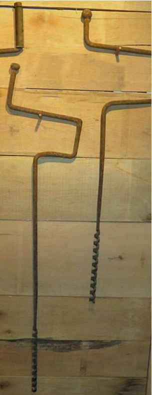
Ice Augers
The auger was used to drill holes into the surface of a frozen pond. A metal ruler with a hook at the bottom end was inserted into each auger hole to measure the thickness of the ice. The ice man would read the number on the ruler that was even with the surface. This allowed the ice cutters to know the thickness of the ice in different places and decide where to begin harvesting.
According to an article in the Connersville News-Examiner by Kate Heron,
“Men with long heavy sharp saws would cut the ice into cakes two feet long, sixteen inches wide and if ten inches thick the cake would weigh 200 pounds.”
“Houses were built for storing ice for summer use. The cakes were packed in sawdust in which the ice kept perfectly.”
“All the ice that was cut and stored by these men [Groff & Waltz] was consumed in Connersville and sold from 3 to 5 cents per pound and you had to carry it home with ice tongs.”
*The link to the right is a short YouTube video about “Ice Harvesting” on an farm in Pennsylvania Farm.
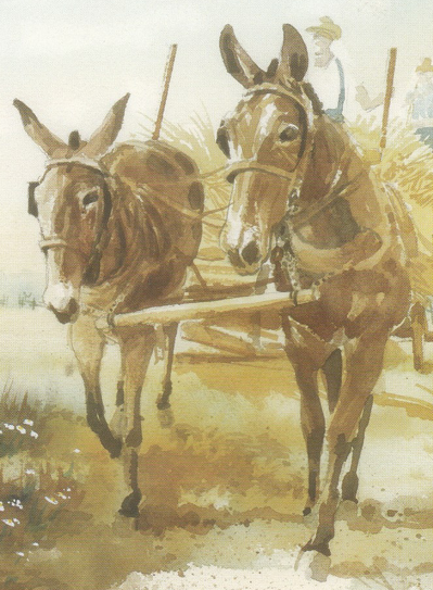
Nature’s Jewel: The Mule
Carolyn I. Schmidt

Photo courtesy of The New Pioneer
A mule is made from a specific recipe. It is a hybrid, a cross between two different species of equine. When a male donkey (a jack) and a female horse (a mare) are crossed their offspring is called a mule. When a male horse (stallion) is crossed with a female donkey (jennet), the resulting foal is called a hinny. These two, mule and hinny, are virtually indistinguishable physically. Horses have 64 chromosomes and a donkey has 62. The mule offspring has 63. Mules can be either male or female, but because of the odd number of chromosomes they are unable to reproduce.
Mules have been used for thousands of years. Mules first appeared in ancient Turkey in the Nicaea region. according to the American Mule Museum located in Bishop, California. Both donkeys and horses lived in the region so it is possible that they mated and produced a mule, but experts think it more likely that their mating was planned at that time.
Before 300 B.C. mules were used in many ways— from beasts of burden to pulling chariots —according to ancient Egyptian history. Many other ancient civilizations—Hittites, Sumerians, Greeks, Romans and others all over the world—used mules and left records of breeding and working them. They considered them highly valuable. Only royalty were allowed to ride them as mounts. In the Old Testament it is related that when the Israelites returned from captivity in Babylonia in 538 B. C., they brought many animals with them, including 245 mules.
The Roman’s were very precise in their Andalusian breeding program for their mules, since the mules carried men and supplies into war. The jacks used to create these mules were up to 15 hands high (a hand was a span of four inches) and bred for their utility, not beauty.
Two jacks and two jennets were brought to the New World by Christopher Columbus on his second voyage. Other explorers, conquistadors and colonists brought their small and scrubby but hearty jacks with them as well. Once the mules arrived a concerted effort was made to enlarge and refine the breed.
George Washington knew how valuable mules would be in farming and as draft animals. He wanted the best breeding stock to breed his mules. He was prohibited in acquiring the Andalusian donkey by the Spanish Government. Luckily when King Charles III of Spain took over the throne he presented Washington with a gift of two jacks and two jennets. Unfortunately one of the jacks died during the voyage. The three surviving mules and their heirs produced most of the American mule population that reached nearly six million by the early 1900s.
By the time of the canal era mules had proven their value. Although oxen and horses were sometimes used to pull canal boats, mules were the beasts of choice by canal boatmen. According to information in the “C & O Boatman,” a good mule could be purchased for $125. Mules were also given credit from C & O Canal workers for their higher mental powers. However, they recommended using mules five or more years of age to perform well. One canawler suggested, “Driving mules into water every day is advantageous because it softens the feet and keeps them moist,” hence their natural suitability in a canal environment…. [it] requires much less food than the horse.” To be kept in good condition, and fit for proper service, it should be fed ten—twelve quarts of grain per day per head, with hay in proportion of about twelve pounds. He also suggested, “There is …a class of mules that are known as Spanish, or Mexican mules. These mules are not large, but for endurance they are very superior….” These were probably the descendants of those brought by Columbus that were mated with the Spanish horses.
Mules are also productive longer, to 35 years. Rarely are horses of use beyond 20, and the ox, 10. The mule has a keen long-term memory, is more agile and lighter on its feet than a horse, has smaller hooves, which don’t get hung up as easily in tight spots, and has better peripheral vision.
Closer to home, Dora Thomas Mayhill describes mules at work on the Wabash & Erie Canal in her book Old Wabash and Erie Canal in Carroll County and Pre-history of the Wabash River. “Mules were hitched to a 250-foot hawser of three-inch hemp made fast to a cleat about halfway between bow and midships, pulled the [canal] boat at about a speed of four to eight miles an hour, fresh teams being taken on every fifteen or twenty miles. Alert drivers, who took pride in smart outfits, industriously groomed their steeds, decorated manes and harness with rosettes, and buffed up leather and brass to a high polish….The slower freight boat, called line boat, carried its mules on board, the driver steering them by the tail on and off over a gangway stored on the roof between times. Generally towed by only one or two, the freighter ambled along at about two miles an hour with a cargo of eighty tons or more.” That translated into about a five day run between Delphi and Fort Wayne, including stops.
Mayhill also states, “On a hard pull over a sandbar, a driver sometimes tried to improve traction by piling sandbags on a mule to hold him down on the towpath.” This is much like we do with a two-wheel vehicle today.
Mules were cherished by their owners. Songs were written about them and the canals on which they worked. Many of these songs were collected by William Hullfish and printed in The Canaller’s Songbook that was printed by the American Canal and Transportation Center. I, Carolyn Schmidt, am especially fond of the song “Simon Slick,” an original Delaware & Hudson Canal song that was unique to the area. It was collected in Sullivan County, New York by John Price. Its second verse is not only funny, but paints a clear picture of the temperament of a mule.
The value of mules is still recognized today by mule celebrations or festivals that are held throughout the United States, especially in rural areas where mules are still used. The top two events are held in Columbia, Tennessee (the self-proclaimed Mule Capital) and in Bishop, California. The dates and information about these events follows:
Columbia, Tennessee
Mule Day—Click the link for schedule
Thursday April 9—Sunday April 12, 2026 with the parade on Saturday April 11 at 11 a.m. in downtown Columbia
Mule Day has been a popular Columbia tradition since the 1840s. It began as “Breeder’s Day,” a single day livestock show and mule market event held on the first Monday in April. Over time Mule Day evolved. The first “official Mule Day was held in 1934, which consisted of the parade, and a mule show in downtown Columbia after the parade. Evolving still, Mule Day went from being a single day event to a multi-day festival, attracting thousands of attendees. Saturday’s Mule Day parade is the highlight of the event. If you visit during Mule Day, you might see a square dance, a mule-driving contest, a horse show, a crafts festival, or attend a flea market. Other events include “working mule,” “best of breed,” or even lumberjack competitions. Traditional Appalachian food, music, dancing, and crafts are featured.
Bishop, California
Bishop Mule Days Celebration, May 19-24, 2026, Bishop, California
A week of Mule events, concerts, and the World’s Longest Non-Motorized Parade plus exciting mule shows, see website for a printable schedule of events.
In 1969 a late winter snow blocked mountain trails limiting recreational opportunities and loss of income. Business remedies were discussed by local packers and the Forest Service Trail Supervisor. Could they create a spring event that focused on packing competitions in Bishop demonstrating the value and versatility of mules and attract visitors? The first Mule Day, a one-day event, was launched in May of 1970 and through the years Mule Days has grown to six days of shows.
Sources:
– Case, Larry, “Mules Rule”, The New Pioneer, Spring 2016: 27-32.
– Bishop Mule Days Celebration, www. muledays.org
– Hullfish, William, The Canaller’s Songbook, American Canal and Transportation Center, York, PA 1984:11.
– Mayhill, Dora Thomas, Old Wabash and Erie Canal in Carroll County and Pre-history of the Wabash River, Knightstown, Indiana:
– Banner Publishing Company, 1953 and 1973 reprint with corrections.
– Mule Day—visit Columbia, Tennessee www.visitcolumbiatn.com/events ‘mule day’ for schedule
– Shaw, Ronald E., Canals For A Nation: The Canal Era in the United States 1790-1860, Lexington, Kentucky: University Press of Kentucky,1990.
– Yoder, Susan, “Mule Shoes”, Canal Society of Indiana Newsletter, February, March, April, May, June, July, August September, and October 2000.
Monster From The Central Canal
Detective Wayne Sharp, Indianapolis Police Department
The rookie patrolman responded to the report of a serious automobile accident in the 3800 block of White River Pkwy [in Indianapolis]. Upon his arrival, there were several other IPD officers on the scene as well as an emergency ambulance.
A car had crashed into the bridge, which carried 38th Street over the Indianapolis Water Company Canal [Central Canal]. This car was not badly damaged however and it was estimated that the speed of the vehicle had been around 25 MPH before it hit the bridge.
Nevertheless, the driver of the car was dead. He was still in the driver’s seat and there were extensive injuries to the area of his right shoulder. In fact the right arm was completely missing. The injuries sustained by the driver were not consistent with the damage to the vehicle he had been driving, not to mention the arm was missing.
It was obvious to any investigator that the driver received his injuries, not in the car crash, but in some incident or event prior to the crash. It was also very obvious that the deceased driver could not have gone very far in the horrible condition he was in. It now seemed certain the driver had been injured and then passed out while he was driving and then the car struck the bridge.
Several policemen retraced the route that had been driven by the mortally wounded motorist and located a pathway which led to the canal. The path was only a few hundred feet away from the crash scene. A trail of blood led from the roadway, up the path, to an area along the canal.
The path led to another path than ran parallel to the canal. This path was not then paved for joggers and was most likely what was still left of the original tow path once used all along the canal route.
At a location along the canal was a large conglomeration of blood. From this spot the trail of blood led back to the roadway. The question now remained to be resolved. What had fatally injured the man as he stood along the canal? What had torn his arm off of his body?
The young rookie patrolman was quick, perhaps too quick to come up with a possible scenario for the events leading to the death of the motorist. The patrolman reasoned that the man had been injured and made his way down the path to his car. He then had managed to start the car and to drive it a short distance, until he passed out from loss of blood. Then the man’s car crashed into the bridge.
So far, all of the officers on the scene agreed with the rookie. Then the young cop went on the explain the initial sequence of possible events. It was plain to understand exactly what had happened. Some sort of creature had crawled out of the canal and attacked the citizen. What else could possibly explain a man standing along the canal, then having his arm torn off and later investigators finding no trace of the arm?
The officers stared, for a moment, into the depths of the canal. The water was calm and silent.

Just when it seemed that no other answer was logical, and that perhaps Indy had it’s own version of the Lock Ness monster, right here in the Water Company Canal, an answer crackled over the police radio. A detective was already checking with neighbors of the deceased man. His address had been obtained from his driver’s license found on his body. The address not being far away, a detective had driven over to the house. Finding no one at the address, a neighbor inquired as to what the problem might be. The man, when informed of the fate of his former neighbor said, “Oh, so he finally did it! He always said he was going to take that old vintage World War II hand grenade over to the canal, pull the pin and throw it in the canal.”
The detective returned to the canal and sure enough, parts of the arm were up in a nearby tree, blown there by the force of the blast. Apparently, the grenade had gone off prematurely and all of the other events then occurred.
The rookie patrolman returned to his police car and besides being embarrassed, realized he would in all likelihood, never be a police detective. He now had to brace himself for many months of good natured kidding from his co-workers.
I know this story to be true, because I am that former rookie policeman.
Detective Wayne Sharp
From an event in 1973
This article first appeared in the March 2000 issue of the Canal Society of Indiana Newsletter. At that time Sharp was writing a book Legends in Blue Stories from the IPD and likely included this in his book.
Historical Treasure: Tracing Canal History
Suzy Dunning
Every so often, a piece of history illuminates from the shadows of obscurity that lets us see the past with fresh eyes—like this recently found diagram of the Wabash and Erie Canal, once the engineering marvel that cut across Indiana. The diagram was discovered in the archives of the Vigo County History Center but has no attached identifying information as to where it came from or who created it. After consulting with a few friends at the Canal Society of Indiana it’s believed to have likely come from the canal headquarters which were in Terre Haute.
The diagram displays the obvious skill of someone with drafting and artistic ability. The precise measurements and layout of the canal features indicate the creator would have been knowledgeable about aspects of the canal’s engineering. With accurate dimensions the print illustrates a cross section of a working canal. The width of the canal at water level is shown as 40 feet across and the depth from the bank to the bottom of the water was 8 feet. The canal was constructed in this way to ensure the water remained at a consistent depth of 4 feet. The sketch is printed in white lines on a black thin paper that resembles blueprint paper. Further research into the type of paper may reveal more of the story of this mystery print.
In preparation of a new display in the Special Exhibit Gallery at the Vigo County History Center the research team took a deep dive into local canal history. The Wabash and Erie Canal was a man-made waterway built in the 1800s to connect the Great Lakes to the Ohio River. Terre Haute was an important stop along the canal when it reached the city around 1849. Before the railroad came, the canal made it possible for farmers and businesses in Vigo County to ship goods like grain, pork, and lumber easily. It was a smoother ride and a more affordable method than shipping by wagon. The canal boats were pulled by mules or horses walking along a towpath beside the water. In Terre Haute the canal was eventually abandoned, and railways became the new means for moving goods. Although the canal can no longer be seen in Vigo County, its path shaped the growth of the city. Today, street names and local landmarks such as Riley lock No. 47 still remind us of a time when the Wabash and Erie Canal promised to open Indiana to the wider world.

Outreach Events & Programs
2025 Canaling Near Petersburg, Indiana
Sam Ligget
While working Pioneer Days, October 4 and 5, at Fowler Park for the Vigo County Parks & Recreation Department, we met Charles “Chuck” Clements. He had come to Pioneer Days to see the reenactment of everyday life in an 1800s pioneer village. Chuck struck up a conversation with my wife and me about the timbers from Culvert 151 that are on display in the village. He said he had a friend who may have the remains of a canal structure on his property. If he got the friend’s permission, would we be interested in coming to Petersburg, Indiana, and taking a look at the remains of this structure. Chuck got permission, and we agreed to meet November 12, 2025, to see if these were canal timbers. A railroad trestle sits over the top of this location and creates confusion about whether the remains are canal structure or railroad structure. Chuck thought the lower part was canal and the upper part was railroad but wanted confirmation.
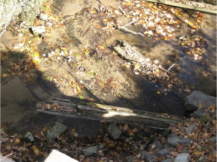
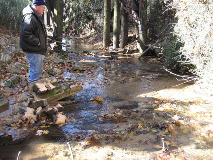
Luckily, November 12 turned out to be a beautiful day. My wife Jo and I left home around 8:30 a.m. and met Chuck at his house in less than 2 hours. We travelled to the farm of Darrel, the property owner. He escorted us out to the railroad trestle, which sits about 20 feet above a creek. Walking out on the trestle and looking down into the clear, shallow water, one can see timbers. These timbers are large, and their widths are not uniform. I knew right away that these timbers were not part of the railroad. I could see they were older than any of the railroad timbers in the area. We drove down to the creek where Darrel and I put on boots and waded through the water to the location of the timbers. We found the sidewall timbers buried in silt. There were large rocks in and around the creek bed. The rocks looked like ones used to protect a canal structure. I came to the conclusion that this was the remains of a Wabash & Erie Canal culvert . The setting for this structure is on the edge of the bluffs of the West Fork of the White River in Daviess County.
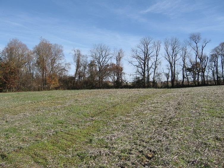
As we were finishing examination of the remains of the culvert, Darrel asked if we would like to see the site of a canal-related cemetery. Our answer was, “Sure.” We drove down the road and eventually to a large field made up of small rolling mounds. This area had been a mass grave for Irish canal workers who died in a cholera outbreak probably in the early 1850s. The site has been investigated and documented by the Indiana Department of Natural Resources. Respect for private property prevents me from revealing the precise location of the culvert and cemetery.
As we travelled the countryside around Petersburg, we were amazed at the number of solar panels and the amount of land taken up by them. It seemed they were everywhere with more under construction. At lunch time, the restaurants were full of construction workers.
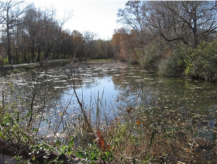
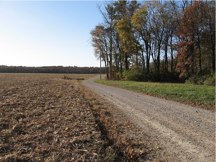
We ate lunch in Petersburg and then drove south on Highway 57. Turning off the highway, we were in Willisville. There is not much at Willisville except a few houses and a section of the Wabash & Erie Canal with water still in it. On one edge of this section runs a county road on what was once the towpath. Part of the other side of this watered section has a steep cut bank. David Kurvach of CSI says the water in this area can be “quite deep.” It is towards the north end of the Patoka Deep Cut.
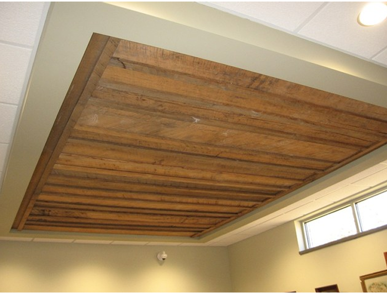
Chuck suggested we visit the Pike County Public Library because it contained some canal-related items. The facility itself is fairly new. At the library, the Special Collections Librarian and Chuck pointed out that one wall and part of the ceiling in one room are covered with wood planking, which was donated by the Rudolph family. It was cut from the timbers of a Wabash & Erie Canal structure that was on their property. This display made a very attractive background for this part of the library. There is a plaque on the wall stating the following: “This paneling was cut from timber used in the old Wabash-Erie Canal. The original planks were cut from oak and poplar timbers, which were used in constructing aqueducts that spanned rivers and streams. Austin and Una Rudolph donated the timbers and had them cut into paneling.”
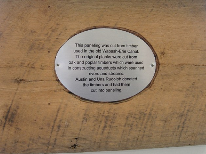
Plaque in Pike County Public Library explaining wall and ceiling planks
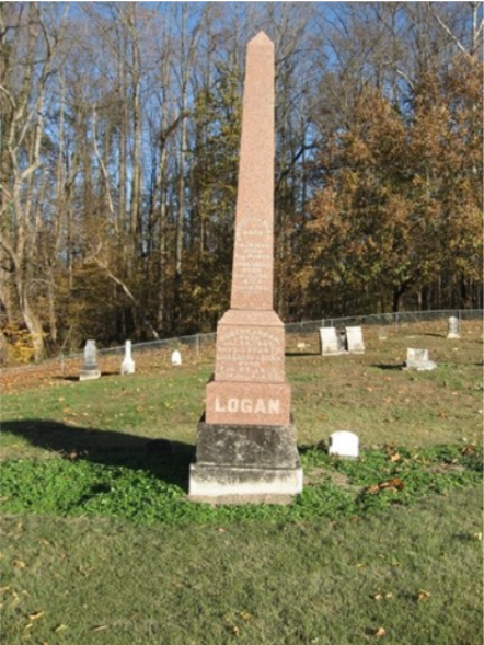
The Pike County Public Library contains some store ledgers of Robert Logan. Logan lived in Highbanks, Pike County, Indiana. He was the contractor for stone locks #46 and #47 in Vigo County near present day Riley, then Lockport. Lock #47 was called “the best lock in the State of Indiana” by resident canal engineer William J. Ball.
We left the library and travelled east to the Logan Cemetery. The cemetery is very well maintained and not hard to find. It was easy to find Robert Logan’s grave as it is a large tombstone in a prominent location. It should have been a short drive down the road to what was once the town of Highbanks, but the county no longer maintains that short section of road. We had to go back to Highway 356 and take another county road to reach the site. Luckily Chuck knew the location well because there is nothing left of the community. The buildings have been removed and what was once Highbanks is now farm land.
We didn’t go to the Pike County Historical Museum on this day but had visited it previously. If you are in the Petersburg area, the museum is worth seeing. Among its collection of items is a small stove that was said to be from a canal boat.
Heading home late in the afternoon, we stopped in Vincennes to eat supper and fill the gas tank. The weather, canal sites, and meeting nice people who were interested in canals and willing to share their knowledge made for a really great day.
Searching for the Old Erie Canal
Ronald V. Morris

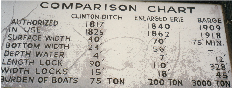
Photo by Bob Schmidt, 1997
The Erie Canal in New York is 200 years old and still working. When Theodore Roosevelt was governor of New York he wanted to maintain a canal presence in New York, and his commission made recommendations that resulted in the present barge canal. The present and third iteration of the canal started operation in 1918. It is no wonder that when a French Company became defunct in early days of the twentieth century that Teddy had the expertise and experience to make this project happen. While I came looking for the original Erie Canal what I found was very pleasant.
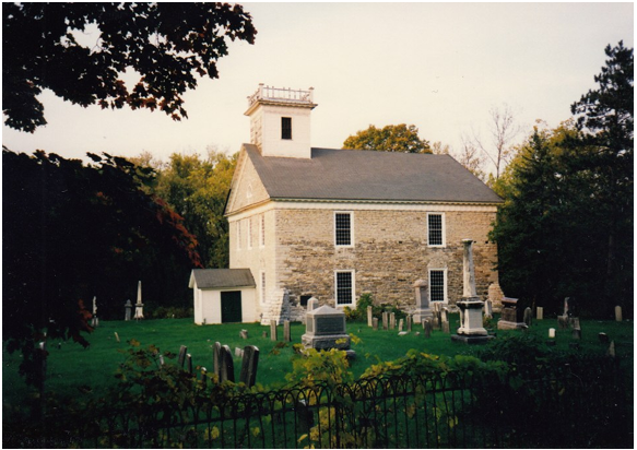
Photo by Phyllis Mattheis, 1997
At Herkimer, New York I boarded a boat for a small trip. Wall banners covered maintenance buildings and shared the story of the development of the canal system in New York.
Visible along the route, the old Herkimer Church was from the time of Fort Herkimer, but the fort was taken for the first canal. The first canal was taken in the construction of the third canal. While there was little historical fabric to see there were trees and under brush with the first brush of fall colors.
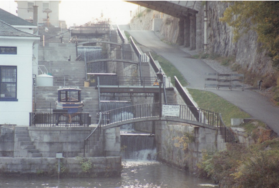
Several years before I took a trip at Lockport on the Erie Canal, and I found this trip as pleasant as the last trip.

At Lockport, New York the Erie Canal had two sets of staircase locks like the one pictured on the left. The other set was to the left of the building.
The staircase of five locks on the left of the building was later changed to two larger locks.
Mohawk River was channelized and turned into a series of ponds. A dam made from metal plates separated the rapids from the created channel which was defended against floods and winter weather by a multiple story green guillotine style guard lock. During the winter weather the guard lock was lowered into place, and the canal was drained. The early twentieth century mechanisms for opening and closing values and doors ran on electric motors, but at that time there was no electric power in the area, so the dam was equipped with hydropower operated direct current generators to make the lock complex sustainable.

This type of gate was found all along the Erie Canal. It operated like a guillotine and could be lowered in time of floods and during winter weather to protect the canal from destruction.
While the Chinese invented the gravity filled and drained lock chamber, DaVinci invented the mitered doors and water pressure actually held the doors closed. He could not have imagined the scale that his work would one day attain. The spillway in front of the lock provided another safety value for protecting the lock, and the lock tender used a control booth at either end of the lock. The gates were opened slowly by thirds. If they would open all the way they would batter the boats in the lock by the force of the water draining.
Utica provided the Five Points Irish pub which was connected to the Irish Cultural Center of the Mohawk Valley and across the street from the historic Catholic Church. It was a good reminder that people who worked on the canal created a new life and home for themselves in the United States. The immigrants who came looking for work found a place where their children’s children established a family connection to a place.
Rome was the site of the Old Erie Canal State Historic Park, a property that has been closed to the public for over fifteen years. Now in private hands it has a lot of aspirations for being a canal destination. A dozen buildings stand as testament to the prosperity of the canal, but when the barge canal was built it went to the north leaving the site and the canal bypassed. It presently provides a trail head for the North Country Discovery Trail which parallels the abandoned second canal. The Discovery Trail takes people from Rome to Port Bryan. If I had had more time, I would have strolled along this trail because I think I would have found more of what I wanted to see in this corridor. It was also the location of the first digging for the original Erie Canal.
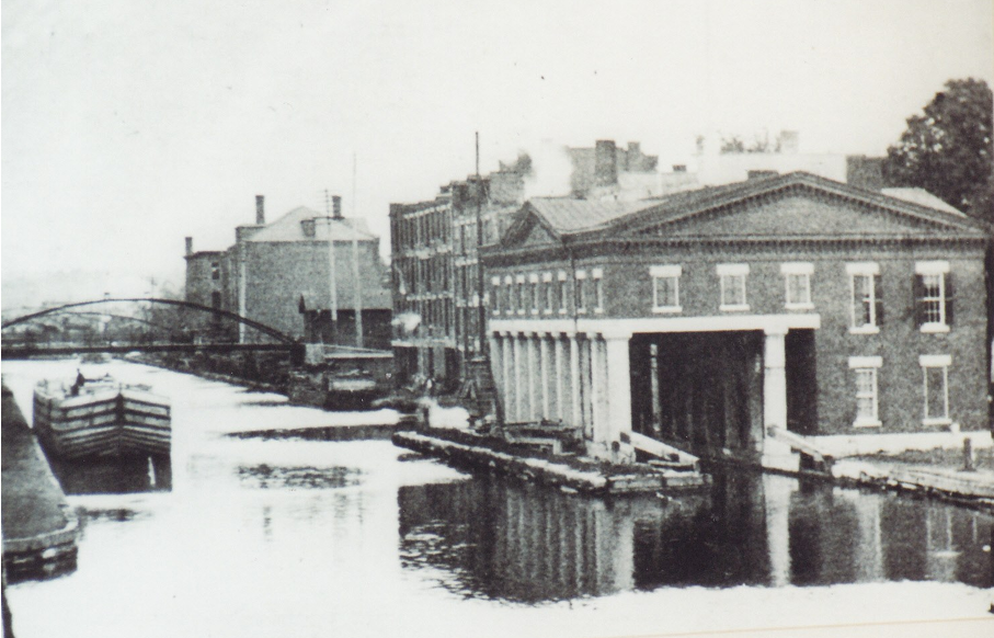
Photo by Lynette Kross, 2003

Photo by Lynette Kross, 2003
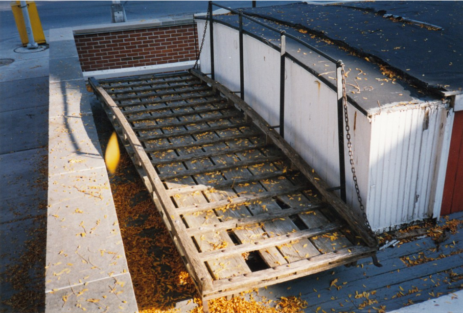
Photo by Bob Schmidt, 1997
Syracuse was the home of an intact weigh lock, and it was more like a railroad siding where the structure paralleled the Erie Canal. A boat would navigate past the lock gates similar to other locks, but there was no elevation change. The water level was the same on both sides of both lock doors; however, there were drain gates that allowed the water to be released from the weigh lock into a nearby creek. Once the water drained from the lock the boat settled onto a cradle at the bottom of the lock which weighed the boat. The weigh master subtracted the weight of the boat from the total weight to get the cargo weight which was converted into the toll. Water would be drained from the canal to refloat the boat, the doors would be opened, and the boat would continue its journey. The two-story Greek Revival structure looked like it had an open car port in the front with the boat pulling into the space where the first floor and basement should be. Inside the structure was a very comprehensive museum focused on the story of the first canal with additional details of the second and third canal. They had some quality videos and computer simulations on how to make a profit by collecting tolls at a weigh lock and how to operate a lift lock. The requisite exhibit panels and artifacts illustrated the exhibit.
There were three exhibits that we do not tend to remember, but this technology assisted in the construction of the canal. The first was the tree topliner, and this device worked like a winch to pull trees to the ground. This saved hours of sawing timber. The second invention was the stump puller which consisted of two sixteen-foot wheels connected by an axel to a center wheel which provided the leverage, with a team of stock, to wrench the stump from the ground. This saved hours of digging stumps out of the ground. The third invention was the boom. Every stone construction such as a culvert, lock, or aqueduct would most likely have had at least one of these. The booms used leverage, ropes, and block and tackle to move stones into position. This saved the back of many workers on the canal.

Photo by Bob Schmidt, 1997

Photo courtesy eriecanalway.org.
Immediately adjacent to the New York I-90 Throughway at Port Bryan was an 1836-1862 enlargement lock. It had two cribs side by side and a double long lock crib on one side, and the tumble passed between the two side by side locks enclosed in a tunnel. The visitor’s center had well designed panels with the story of the multiple building phases of the canal. There was canal ephemera in flow blue china, DeWitte Clinton blue china, a canal horn, a packet boat chair with a low back painted in the black and gold paint of a fancy chair. There were also models, diagrams, and primary sources.
The Erie House was residence, bar, and store featuring the original cash register and bar. The mule barn and blacksmith shop to shoe the mules were next door. While passing through Palmyra I passed a lock park that contained a second canal three arch stone aqueduct and canal bridge.
At Pittsford, a very put together canal town, with canal rides, shopping, walking and cycling. I rode on the Colonial Belle on the barge canal to Rochester. Most of this was on the modern Erie Canal with two locks and a diversion on the Genesse River before returning through the locks. The lock air was cool, a breeze caught us and shaded us from the usual warm fall sun. It was a pleasant way to spend a Sunday afternoon, and it was a charming weekend on the Erie Canal.

Photo courtesy of the Colonial Belle website.
Delphi News

“Key to City” awarded to Dan McCain
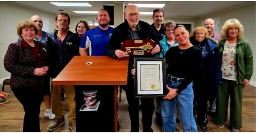
On Monday, January 5, 2026, Dan McCain was presented the “Key to the City of Delphi” award at the
Common Council meeting by Mayor Kamron Yates. Mayor Yates read the following proclamation:
HONORING THE DEDICATION AND SERVICE OF DAN MCCAIN
WHEREAS, the City of Delphi is proud of its rich heritage, which is deeply tied to the Wabash & Erie Canal, once the longest man-made structure in the Western Hemisphere; and
WHEREAS, the preservation and restoration of this historic waterway were made possible through the vision, dedication, and tireless efforts of community-minded citizens; and
WHEREAS, Dan McCain stands out as a pivotal figure in this endeavor, having been a founder of the Carroll County Wabash & Erie Canal Association and serving as its longtime president and now president emeritus; and
WHEREAS, Mr. McCain’s efforts, beginning with initial meetings in his parents’ living room, led to the successful dredging, re-watering, and development of the Canal Park and its award-winning Interpretive Center and Pioneer Village, transforming a stagnant ditch into a vibrant community resource and educational destination; and
WHEREAS, his work has created miles of historic trails, a replica canal boat experience, and preserved local history for generations of residents and visitors to enjoy, significantly enhancing the quality of life and historical appreciation in Delphi; and
WHEREAS, his exceptional volunteerism and community improvement efforts have previously earned him Indiana’s highest honor for a senior citizen, the Golden Hoosier Award; and
WHEREAS, Dan, through his dedicated efforts, was instrumental in acquiring, restoring, and facilitating the reinstallation of several historic bridges including the iconic Freedom Bridge spanning the Hoosier Heartland Highway.
NOW, THEREFORE, I, Kamron Yates, Mayor of the City of Delphi, do hereby gratefully recognize and honor Dan McCain for his profound and lasting contributions to the City of Delphi and the preservation of the Wabash & Erie Canal.
BE IT FURTHER PROCLAIMED, that in recognition of his over half century of service, today January 5, 2026, Dan McCain shall be honored with the “Key to the City” of Delphi, IN, Carrol County.
From the Whitewater Valley
Statehouse Update: Metamora Funding Moves Forward
Cassie Garrett
Senate Bill 57, authored by Senator Jean Leising, which would transfer management of Indiana’s historic sites back to the Department of Natural Resources, passed out of committee today and will next head to the appropriations process. During the hearing, senators across the committee took the issue seriously, openly expressing frustration and concern over long-term underfunding and the challenges of preserving historic sites without adequate resources.
Most importantly, it was announced during the hearing that the $7 million matching grant for Metamora and the Whitewater Canal State Historic Site is expected to be released within the week, a move that would unlock the State of Indiana’s $7 million allocation already approved by the General Assembly. Taken together, that means approximately $14 million in funding for long-overdue repairs at Metamora should be moving forward very soon.
While discussions continue about whether site management should change, one thing became clear during the hearing: the funding is coming. Regardless of the outcome of Senate Bill 57, the financial commitment to preserving Metamora and the Whitewater Canal State Historic Site is advancing.
Whitewater Canal Scenic Byway’s Gateway Park
Cassie Garrett
Welcome to Gateway Park where history, creativity, and community come together. Located along the Whitewater Canal Scenic Byway, this site is home to our visitors’ pavilion, campground, and historic train depot.
We’re excited to share the Whitewater Canal Scenic Byway Visitors Pavilion, which is planned to open this May. It will feature:
- Local artisan displays from across Ripley, Franklin, Dearborn, Fayette, Union, and Wayne counties
- Information on what to see and do throughout the Byway and then sending visitors to local tourism offices for a more tailored experience
- Stories and history of the Whitewater Canal and the Whitewater Valley
We are currently seeking local artisans to feature their work in the Pavilion. If you create something special and would like to be part of this regional showcase, please send us a private message for details. Space is limited.
We are also seeking volunteers to help staff the Pavilion. We’re a small, all-volunteer board, and we’ll start with Saturday hours, with the goal of opening on Sundays as more volunteers join us. If you enjoy meeting visitors, sharing local history, or supporting the arts and tourism, we would love to hear from you. Just send us a private message.
Inside the Pavilion, visitors will also be able to view beautifully hand-built scale models created by local historian and former WCBA board member Paul Baudendistel. These detailed models depict the aqueduct, canal boat, Mill Park, and a canal lock, bringing the remarkable story of the Whitewater Canal to life.
Be sure to keep an eye on our Facebook page as we share more about the campground and the historic train depot.
Canal Society of Indiana
News and Programs
New Members
The following persons joined the Canal Society of Indiana at the $20 membership level or received a gift membership unless otherwise noted. Welcome aboard!
Darrel Barber Washington, IN Gift from Sam & Jo Ligget

Memoriam
Let us remember those we have lost
Gene A. Paschka
November 15, 1954—January 22, 2026
Find-A-Grave #291820014
Gene A. Paschka, 71, of Roanoke, Indiana, passed away on Thursday January 22, 2026. at Fort Wayne’s Lutheran Hospital. He was born to the late Theodore and Marcella (Heine) Paschka in Fort Wayne on November 15, 1954. He married Joyce A. Hartman on August 14, 1982 at Our Redeemer Lutheran Church in Kokomo, Indiana.
While growing up Gene was a Boy Scout and achieved the rank of Eagle Scout where he learned about serving others. He continued his service as an usher and a deacon at St. Peter’s Lutheran Church and St. Paul Lutheran Church, both in Fort Wayne; St. John Lutheran Church-Bingen where he and Joyce were members; and, after moving to Roanoke, they became members of Faith Lutheran Church.
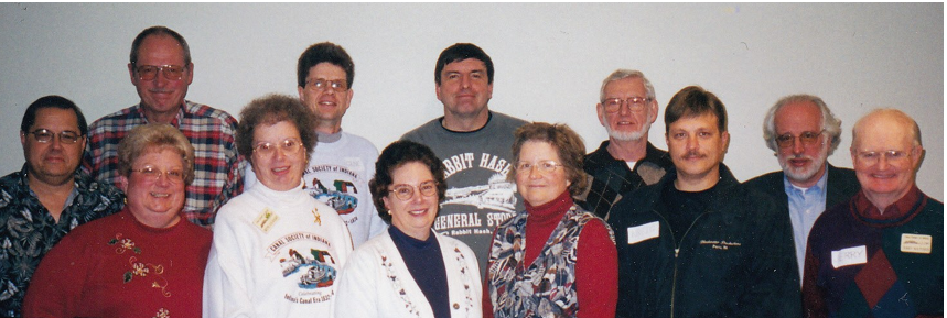
Back row: Bob Schmidt, Dan McCain, Gene Paschka, Mike Morthorst, Jim Ellis, Chuck Huppert
Front row: Carolyn Schmidt, Betty Tarr, Sue Simerman, Cynthia Powers, Kreig Adkins, Jerry Mattheis
Gene also served on the Canal Society of Indiana’s Board of Directors from 1996—2004. He and Joyce attended many CSI canal tours and Gene helped with some of them.
After graduating from Concordia Lutheran High School in 1973, Gene attended a trade school for plumbing and heating and then studied Culinary Arts at Ivy Tech.. He was employed by W.C. Borchelt as a heating and plumbing installer. He became an assistant chef at Goeglein’s Catering, the Fort Wayne Coliseum, and Ceruti’s. He also worked as a produce clerk at Kroger.
Wayne in 2016
Gene spent many cherished hours with his nephews and nieces taking them to Chicago Cubs games and the Fort Wayne Children’s Zoo. In his free time he enjoyed ice skating and synchronized skating as a member of the Fort Wayne Ice Skating Club and also found great pleasure in gardening and tending to his flowers. Gene and Joyce ushered for several years at Fort Wayne’s Embassy Theater.
He is survived by Joyce, his wife of 43 years; mother-in-law Opal Hartman of Kokomo, Indiana; Joyce’s sisters, Linda (John) Alley of Rochester, Indiana; Marge Bunn of Kokomo, Indiana, and Patti (Tom) Stout of Kokomo, Indiana; 17 nieces and nephews; and 44 great-nieces and nephews.
He was preceded in death by his brother, Stanley Paschka.
Family and friends were received for 10 am to noon prior to his funeral service at St. John Lutheran Church, Bingen located a 11555 U.S. 27 in Decatur, Indiana, 46733.
Pastors Berett Steffen and Peter Brock officiated at his funeral service, which was held at 12 noon on Wednesday, January 28, 2026, followed by burial in St. John Lutheran Cemetery- Bingen.
Suggest memorials were to St. John Lutheran Church- Bingen, Worship Anew or Turnstone.
Funeral arrangements were made by Zwick and Jahn Funeral Homes of Decatur, Indiana
Gerald (Gerry) Earl Hulslander
Aug. 12, 1925—Jan. 25, 2026
Find-A-Grave #
Gerald Hulslander, a long-time resident of Ottawa, IL passed away peacefully on Sunday, January 25, 2026, at age 100.
Gerald was born in Geneseo, Illinois, to Earl and Bertha (Petersen) Hulslander on August 12, 1925. His early years were spent in farm country with his older sister Marjorie and younger brother Curtis. Before and after classes at the one-room Hulslander school and Geneseo High School, he worked in the local dairy delivering milk.
As the US entered WWII, he enlisted in the Navy and at the age of 17 trained as a Torpedoman. Much of his service was spent in the Pacific theatre aboard the USS McNair, a Fletcher class destroyer. During the invasion of the Philippines, his ship led the battleship USS West Virginia into Leyte Gulf, a memory that never left him. He later went on an Honor Flight to Washington D. C. for his service.
After the war, Gerald furthered his education at the University of Illinois in Champaign. While pursuing a degree in Agriculture, he met and married the love of his life, Jean (Muntz). He accepted a job as Fieldman with the Farm Bureau Service and they moved to Paw Paw, IL where they started their family of four children. Another move brought them to Ottawa where they joined Trinity Lutheran Church, made life-long friends, and Gerry served there as usher, lector and council member for many years.
His love of story-telling and history led to numerous family camping trips across the US where he stopped at every roadside marker, point of interest and scenic overlook along the highways. He also organized trips with area farmers, taking them via bus or train to learn about farming in other parts of the Midwest and beyond. The story-telling continued when he had a talk show on local radio WCMY with fellow historian Ron Slack discussing county seats, one-room school houses, etc.. He and Jean also spent hours bringing Ag in the Classroom to schools in Chicago, impressing the students with ears of homegrown field corn and popcorn, stalks of rhubarb and rhubarb cakes. Other stories were shared at the Civil War Roundtable, LaSalle County Historical Society Museum and Utica Burgoo Festival.
Jean and Gerald’s home was always open to friends, children of friends, and friends of their own children. Visitors would be told stories and jokes while eating a hot meal or plates of cookies. His quick wit was often greeted with both laughter and groans.
Gerry and Jean were long-time members of the Canal Society of Indiana and attended many of its tours. He helped organize and led canal tours of the Illinois & Michigan Canal (1996, 2009 & 2017) and was instrumental is setting up a tour of the Hennepin Canal (2012). He participated in various canal projects on the I & M Canal that are covered in news paper clippings found at the library in Morris, Illinois. These include his part in restoring the Fox River Aqueduct and his relating the history of the canal to others.
After Jean passed away and Gerry began having health issues he moved to Pleasant View Lutheran Home in Ottawa in 2022. There he found a new audience for his stories and he often entertained the staff and residents with his harmonica. He could always be counted on to help new residents acclimate and assist others with dining.
To celebrate his 100th birthday, his children held an open house on Sunday, August 10. 2025 at Trinity Lutheran Church, in Ottawa. His actual birthday was two days later on August 12.
Gerald was preceded in death by his parents, sister and brother, his wife Jean and eldest daughter Ellen (White). He is survived by his son David (Betsy) Hulslander, daughter Carol Kennedy (Ray Klein), daughter Sarah Hulslander, proxy-daughter Sue Williamson, and Aussie son Barry (Ann-Louise) Richardson. He is further survived by foster children Rob (Sunny) Smeets, Diane Lewis and Roger (Val) Smeets.

Gerry considered himself blessed with eight grandchildren, eight great-grandchildren, and two great-great-grandchildren whom he loved dearly and was extremely proud of.
The family thanks the staff of OSF Hospital and the Hospice Care team for their kindness to Gerald in his last days. They especially thank the staff and 4th Floor care team at Pleasant View for their care, concern, patience and love for him over his years there.
Visitation was at Trinity Lutheran Church 717 Chambers St in Ottawa on Sunday, February 1 at 1:30pm with funeral services following at 3:00pm. Burial was in Grand View Cemetery in Atkinson, Illinois. Arrangements were made by the Mueller Funeral home in Ottawa.