
- Analysis of Covington Clearance Records
- Canal Notes # 18: Roads And Ways
- Dendrology of Culvert #151 Timbers
- Looking For Whitewater Lock #14
- South Of Cedar Grove—
- A Cook’s Tale (1890)
- CSI Member’s Milestones
- Vanished Indianapolis
- Repaired Central Canal Marker Dedicated
- Moving West
- More of the Tatum’s Family History
- Whitewater Canal Article
- Canal Timbers In Storage Room
- Delphi Builds Boardwalk To Bayou
- “Summit Canals” Symposium
Analysis of Covington Clearance Records
Robert Schmidt
During the COVID pandemic in 2022, CSI Member Lowell Griffin computerized the Covington Clearance/Toll Book records that CSI had previously copied 27 years earlier (“The Tumble” September 2022). Using these records I have tried to analyze them to better understand the details of commercial traffic on the Wabash & Erie Canal.
At Covington we found two types of canal boat record books:
The first type of book is labeled “Amount checked against Officer at Lafayette or Terre Haute” and is a listing by day & month. This is a Toll Clearance Record that reveals boats that passed through Covington from 1849-1856 after having paid a toll at either Lafayette or Terre Haute. The purpose of these records was to assure that boats passing through Covington had previously paid their tolls at their initial toll collection station. As boats arrived, the Collector at the dock reviewed the bill of lading, the toll paid and logged an entry in the clearance record book. If no toll had been paid it was then collected at Covington.
The second type of record found at Covington begins in 1860 and was for tolls collected there. This type of record also has more information about the cargo and toll calculations. This record is a duplicate of the bill of lading provided by the boat captain. I plan to cover these Toll Records in a later article.
In order to understand the construction dates, distances and toll records of the Wabash & Erie Canal you need to have a good understanding of canal mileages. Indiana had 380 miles and Ohio had 88 or a total distance of 468 miles. Four of the Ohio miles were from Toledo east to Manhattan on Lake Erie so the total mileage to Toledo is 464 miles. The following mileage, chart showing the Lafayette to Terre Haute area is to assist in understanding my article.
Canal Mileage
| Increment | State Line | Completed | |
|---|---|---|---|
| Ohio Completed | 84 | 1843 | |
| State Line | 0 | 0 | 1840 |
| Ft. Wayne | 20 | 20 | 1835 |
| Lafayette | 118 | 138 | 1840 |
| Attica | 23 | 161 | 1846 |
| Williamsport Side Cut (SC) | 1 | 162 | 1852 |
| Covington | 13 | 175 | 1846 |
| Perrysville SC | 7 | 182 | 1847 |
| Lodi | 7 | 189 | 1847 |
| Sugar Creek Feeder | 8 | 197 | 1847-49 |
| Montezuma | 5 | 202 | 1847/49 |
| Clinton Locks | 10 | 212 | 1847/49 |
| Terre Haute | 14 | 226 | 1849 |
| Lafayette | to | Terre Haute | 88 | Miles |
| With (7 Timber Locks) | 84 | Ohio Miles | ||
| Terre Haute | to | Toledo | 310 | Total Miles |
By 1840 Indiana’s portion of the Wabash & Erie Canal extended 138 miles, from Lafayette to the State Line termination. Ohio, delayed by a boundary dispute with Michigan and work in progress on her other canals, did not begin construction at Toledo on the Wabash & Erie until 1837 and even then proceeded slowly through the Black Swamp west of Defiance. Indiana was very impatient and was concerned that Ohio didn’t proceed faster. Both states began working toward the border in 1837. Indiana had only to dig 19 ½ miles of canal east of Fort Wayne and construct 3 locks ( Saylor, Gronauer & Taylor.) Their source of water, the St Joseph Feeder, was already in place so their works were completed in just 2 ½ years. On the other hand, Ohio had to construct 84 miles of prism. For a water supply they had to build 2 feeder slackwater dams on the Maumee and a 6-Mile Reservoir near Antwerp. They also completed 20 stone locks from Junction to Toledo and 6 timber locks through the Black Swamp from Junction to the Indiana state line. This all was accomplished in just 6 years from 1837-43 The “Albert S. White” was the first boat that traveled from Lafayette, Indiana to Toledo, Ohio in May 1843.
For the nine years from 1840 until 1849 when Terre Haute was finally reached, Lafayette was the key western terminus of the Wabash & Erie Canal and therefore developed a brisk trade to the east. Over this time the town built up a major port around canal activities that persisted well beyond 1849. It was the toll collection point.
In 1839, with financial difficulties, Indiana stopped all transportation improvement projects except the Wabash & Erie Canal. Construction below Lafayette was aided by another federal land grant in 1841. Work proceeded slowly to the south for the next 5 years from 1842-47. Although land from two grants was sold for the goodly price of $4 per acre, much of it was on credit, not cash. Promissory notes in the form of Blue Dog ($5) and Blue Pup ($1) were used to pay contractors and workers.
When canal construction finally reached Covington in 1846 there was only enough water to fill the prism to Attica, which was 14 miles north of Covington. That year, when the first canal boat reached Attica, the town refused to let the water pass through the gates of Lock No.35 toward Covington. The reason was due to an inadequate water supply in the upper levels of the canal. Failing to recognize this hydraulic problem the Covington residents felt that Attica was retaining water to prevent them from using the canal. This turned into a real political crisis when their resident Indiana Senator Edward A. Hannegan led a mob from Covington to open the Attica lock in the fall of 1846. The effort failed but this skirmish is often called the “Canal War.”
The canal finally reached Coal Creek at Lodi in 1847. The first boat, “The Planet,” arrived there on October 2nd. Perrysville across the Wabash River in Vermillion County had become a shipping center on the Wabash River. Anticipating the plans for the canal on the eastern side of the Wabash, the residents of Perrysville decided to build a side-cut off the main canal. By 1847 when the canal reached Lodi, Perrysville had their side-cut in place. The leakage and use of the Perrysville Side-cut, added to the water shortage on the canal from Lafayette to the Sugar Creek Feeder. Williamsport upriver in Warren County also wanted a side-cut and built their own by 1852 despite the protests of canal officials.
Under the terms of the “Butler Bill” the Wabash & Erie Canal was transferred on July 1, 1847 from the State of Indiana to a Trust headquartered at Terre Haute. Construction rapidly proceeded south from Lodi for 37 miles to Terre Haute. On October 25, 1849, the “Edward A. Hannegan” was the first boat to reach Terre Haute.
From the Annual Report to the Indiana General Assembly of 1848, we learn that Covington began clearing boats and collecting tolls in May 1847. The official published information reveals the tolls collected each month. For the year 1847 the total collected was $2,503, 1848 – $13,111 and later in 1850 – $12,170. These tolls were for shipments that originated in Covington. Tolls for shipments originating north in Lafayette or south in Terre Haute were collected at those respective sites and recorded in the Clearance books.
The Covington Clearance Book records for 1850 are labeled “Amount checked against officer at Terre Haute or Lafayette” and with the following format:
| Clearance | Date & Number | Boat Name | Clearance Location |
| Destination | Date Checked | $Toll – Terre Haute | $Toll – Lafayette |
The first listing of boats from Terre Haute appear in the spring of 1850. A few destinations were for Fort Wayne or the Indiana/Ohio State Line, but most destinations listed were at points between or at Terre Haute or Lafayette. The only boats listed on these clearance records are those boats which paid a full or partial toll at Lafayette or Terre Haute. Other tolls were collected in full, where the boat passed a collection point listed as the point of origin These clearance records show a toll paid by a several boats going from Terre Haute to the State Line, but there is no record for the return trip since their toll was paid elsewhere. There are repeats monthly for the same boat, but they have different dates from Terre Haute to the State Line. Some boats are listed as Packets (passenger boats). The 1849 records does show a packet travel from Lafayette to Covington by the Packet “Indiana.”
The records for 1850 still show that most of the boat traffic was short distances between Lafayette and Covington, the Perrysville Side-cut and then Terre Haute. Outside of this local traffic the long distance traffic was mostly to Fort Wayne or the State Line. This type of clearance record provides no other details about commodities carried or other cargo. After 1850 when Terre Haute opened up, there are frequent entries for packet travel, such as the packets: “Indiana,” “Missouri,” “Illinois,” “Iowa,” “Ohio,” “Silver Bell,” etc.
Even though these records are only a partial inventory of the total number of boats passing through
Covington, we can gain information about boat traffic. In the 3 months from May to July 1849 there were 67 different boats making 87 trips. Before Terre Haute opened in 1850 most of the traffic was from Lafayette to Covington with some to the Perrysville Side-Cut and still fewer to Lodi at Coal Creek. The Covington 1850 records show an increase to about 107 different boats passing through Covington from Lafayette and Terre Haute.
The names of the boats for persons, places and things are very interesting. Here is a listing for 1850 of some of the 94 different boats and their 346 itineraries from the Covington Clearance Records:
Canal Boats passing through Covington in 1850
paying tolls at Terre Haute or Lafayette, Indiana.
| Boat Names | (No. Times) Destination -Direction | Total Trips |
|---|---|---|
| A J Smith | (2) Lafayette – South (3)Terre Haute – North (1)Fort Wayne – Southwest | 6 |
| A Wiman | (1) Terre Haute – State Line | 1 |
| Aeolus | (2) Lafayette – South (2) Terre Haute – North (1) Terre Haute – State Line | 5 |
| Alabama | (1) Lafayette – South (1) Terre Haute – State Line | 2 |
| Amelia | (1) Fort Wayne – South (1) Terre Haute – State Line | 2 |
| Ben Barkalow | (1) Terre Haute – State Line | 1 |
| Ben Bolt | (1) Fort Wayne – South (1) Terre Haute – North | 2 |
| Buffalo | (1) Fort Wayne – South | 1 |
| Buck Creek | (1) Terre Haute – North | 1 |
| C Bucklin | (1) Lafayette – South (1) Terre Haute – North | 2 |
| C Taber | (1) Terre Haute – North | 1 |
| C G Roby | (2) Terre Haute – State Line | 2 |
| C R Walker | (1) Lafayette – South (1) Lafayette – State Line | 2 |
| C S Vigus | (2) Lafayette – South | 2 |
| Caledonia | (1) Lafayette – State Line (1) Terre Haute – North | 2 |
| California | (1) Fort Wayne – South | 1 |
| Cicero | (1) Lafayette-South (1) Terre Haute – North (2) Terre Haute – State Line (2) Fort Wayne – South | 6 |
| Cincinnati | (1) Lafayette – South (1) Terre Haute – State Line | 2 |
| Clarion | (1) Terre Haute – State Line | 1 |
| D R Atwater | (1) Terre Haute – State Line (1) Fort Wayne – South | 2 |
| De Witt Clinton | (1) Lafayette – State Line (1) Terre Haute – State Line | 2 |
| Diadem | (1) Lafayette – South | 1 |
| E A Hannigan | (1) Lafayette – State Line (1) Terre Haute – North (6) Terre Haute – State Line (2) Fort Wayne – South | 10 |
| England | (2) Fort Wayne – South (1) Terre Haute – North | 3 |
| Eugene | (6) Terre Haute – North | 6 |
| Excelsior | (1) Lafayette – South (1) Terre Haute – State Line | 2 |
| F J King | (1) Lafayette – South | 1 |
| Friendship | (1) Lafayette – Sout | 1 |
| G B Walker | (1) Terre Haute – State Line | 1 |
| G H Standard | (2) Terre Haute – State Line (1) Fort Wayne – Southwest | 3 |
| General Pike | (1) Lafayette – South (1) Terre Haute – State Line (1) Fort Wayne – South | 3 |
| Globe | (1) Terre Haute – State Line | 1 |
| Gold Hunter | (1) Lafayette – South (1) Terre Haute – North (1) Terre Haute – State Line (2) Fort Wayne – South | 5 |
| H M Thomas | (1) Lafayette – South | 1 |
| Hoosier Boy | (1) Lafayette – South | 1 |
| Hull | (1) Terre Haute – State Line | 1 |
| Hurricane | (1) Terre Haute – State Line (1) Fort Wayne – South | 2 |
| I L King | (1) Lafayette – South (2) Terre Haute – North (3) Terre Haute – State Line (1) Fort Wayne – South | 7 |
| Iowa | (8) Lafayette – South | 8 |
| Isabella | (1) Lafayette – South (3) Fort Wayne – South | 4 |
| J A White | (1) Lafayette – South (2) Terre Haute – North | 3 |
| J Q Adams | (2) Terre Haute – State Line | 2 |
| John Ferry | (1) Lafayette – South (2) Lafayette – North (3) Fort Wayne – South | 6 |
| John Hollister | (4) Lafayette – South (4) Terre Haute – North (3) Terre Haute – State Line | 11 |
| John Miller | (1) Terre Haute – State Line (1) Fort Wayne – South | 2 |
| John R Porter | (2) Terre Haute – North (5) Terre Haute – State Line | 7 |
| Juaniati | (5) Lafayette – South (3) Terre Haute – North | 8 |
| Judge Borden | (1) Terre Haute – North | 1 |
| Jupiter | (1) Lafayette – South | 1 |
| Laura Ann | (1) Lafayette – South | 1 |
| Live Yankee | (1) Lafayette – South (1) Terre Haute – State Line (1) Fort Wayne – South | 3 |
| Louisiana | (1) Lafayette – South (1) Terre Haute – State Line | 2 |
| M Taylor | (1) Terre Haute – North | 1 |
| Maine | (1) Terre Haute – State Line (1) Fort Wayne – South | 2 |
| Milton | (2) Terre Haute – North (1) Lafayette – South | 3 |
| Mohigon | (1) Terre Haute – State Line | 1 |
| Montezuma | (1) Terre Haute – State Line | 1 |
| N F Swan | (1) Lafayette – South | 1 |
| Nahmeaker | (1) Terre Haute – State Line | 1 |
| North America | (1) Lafayette – South | 1 |
| O W Jeffords | (1) Lafayette – South | 1 |
| Oceola | (2) Terre Haute – North | 2 |
| Odd Fellows | (1) Terre Haute – State Line (1) Fort Wayne – South | 2 |
| Ohio Trader | (1) Lafayette – South | 1 |
| Orion | (1) Terre Haute – South (6) Terre Haute – State Line (3) Fort Wayne – South | 10 |
| Packet Empire | (12) Lafayette – South (11) Terre Haute – North (2) Terre Haute – State Line (2) Fort Wayne – South | 27 |
| Packet Illinois | (2) Lafayette – South (1) Lafayette – State Line (18) Terre Haute – North (3) Terre Haute – State Line | 24 |
| Packet Indiana | (5) Lafayette – South (1) Lafayette – State Line (11) Terre Haute – North (2) Terre Haute – State Line | 19 |
| Packet Laurel | (8) Lafayette – South (1) Lafayette – State Line (11) Terre Haute – North (3) Terre Haute – State Line | 23 |
| Packet Missouri | (7) Lafayette – South (17) Terre Haute – North (4) Terre Haute – State Line | 28 |
| Packet Ohio | (2) Lafayette – South (2) Terre Haute – North (3) Terre Haute – State Line | 7 |
| Paul Jones | (1) Lafayette – South | 1 |
| Poland | (1) Terre Haute – State Line (1) Fort Wayne – South | 2 |
| Potomac | (1) Terre Haute – State Line (1) Fort Wayne – South | 2 |
| President | (1) Fort Wayne – South | 1 |
| R W Lee | (2) Terre Haute – State Line (1) Fort Wayne – South | 3 |
| Ringgold | (2) Terre Haute – State Line (2) Fort Wayne – South | 4 |
| S H Dudley | (1) Lafayette – South (1) Terre Haute – State Line (2) Fort Wayne – South | 4 |
| Sam Hubbard | (1) Lafayette – State Line (1) Fort Wayne – South | 2 |
| Samuel N Pike | (1) Terre Haute – State Line | 1 |
| Saramae | (1) Terre Haute – North | 1 |
| Spy | (6) Lafayette – South (1) Lafayette – State Line (1) Terre Haute – North | 8 |
| T Hamilton | (1) Lafayette – South | 1 |
| T T Bloomer | (3) Fort Wayne – South | 3 |
| Tecumseh | (2) Lafayette – South (1) Terre Haute – State Line | 3 |
| Tom Watkins | (1) Lafayette – South | 1 |
| W G Ewing | (1) Terre Haute – North | 1 |
| W H Hatcher | (1) Lafayette – South (2) Terre Haute – North | 3 |
| W O Butler | (1) Lafayette – South (1) Terre Haute – North | 2 |
| Wilfred Smith | (1) Lafayette – South | 1 |
| William Dale | (2) Lafayette – South | 2 |
| William Hollister | (1) Fort Wayne – South | 1 |
| Wing and Wing | (1) Fort Wayne – South (1) Terre Haute – State Line | 2 |
| Wyandott | (2) Fort Wayne – South (1) Lafayette – South (1) Terre Haute – North (2) Terre Haute – State Line | 6 |
| Total Boats Recorded | 363 |
Canal Notes # 18: Roads And Ways
Tom Castaldi
Where boats once plied Wabash & Erie Canal waters, now cars and trucks make journeys on roads named Canal Street in Fort Wayne, Roanoke, Huntington, Peru, Lafayette and points south in Indiana. Water Street in Wabash and, in Logansport, Erie Avenue stands where water once provided the means of travel. In Miami County there is even a town named Erie taken from the days when canal fever swept popular opinion. Canals and roads meant improvements for new states such as Indiana because it opened up world markets for getting goods and services in and out of an otherwise land-locked area.

Most of these towns have a Clinton Street named for the father of the Erie Canal and once governor of New York. DeWitt Clinton pushed for and opened the great Erie Canal in 1825 and, in 1843 at the grand celebration for the Wabash & Erie, said that the people of Indiana had shown the way for his New York canal to reach the west.
On Fort Wayne’s south side, Clinton intersects Williams, a street in the addition organized by Jesse Lynch Williams who, after serving as chief engineer for the Wabash & Erie, was sent by Abraham Lincoln to take charge of building the eastern link of the great Union Pacific Railroad. He’s no doubt one of the people pictured in the illustration showing the golden spike being driven to connect east with west at Promontory Point.
Other street names are recognizable from canal pioneers such as Fairfield, Rockhill, Hanna, Mahon, Case, Tipton and Edgerton to name a few.
Whatever the name, people and goods got their start moving along a canal and they haven’t stopped yet. Perhaps it is well that we take a moment to remember in these streets the names of the people of times long past who were responsible for building the towpaths that made our pathways possible.
Dendrology of Culvert #151 Timbers
Sam Ligget
The discovery of the timbers in Little Honey Creek that were a part of the Cross-Cut Canal Culvert # 151 made an analysis of at least these timbers possible. The timbers were uncovered as a result of construction of the Highway 641 by-pass around Terre Haute, Indiana, in the spring of 2007.
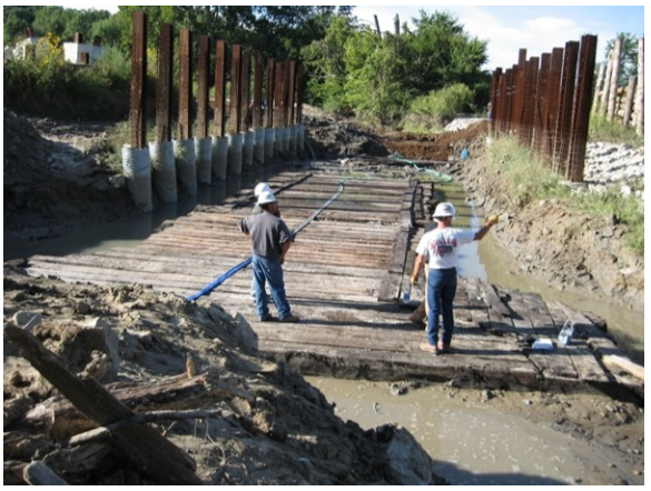
These timbers were put in the care of the Vigo County Parks and Recreation Department. Concerned about the stability of the timbers once they were removed from the Little Honey Creek creek bed, the Parks Department granted the Department of Earth and Environmental Systems at Indiana State University permission to examine the timbers. Dr. James H. Speer and Rebecca Taormina were charged with the gathering of data from the timbers of Culver # 151. They undertook a dendrochronological study of the timbers.
Dendroarchaeology can be used to analyze the wood from the construction of old structures such as canals, barns, mills, etc. to provide information concerning the age and mix of tree species used in their construction. Using existing master chronologies, a correlation can even suggest a geographical area that was the source of the wood used.
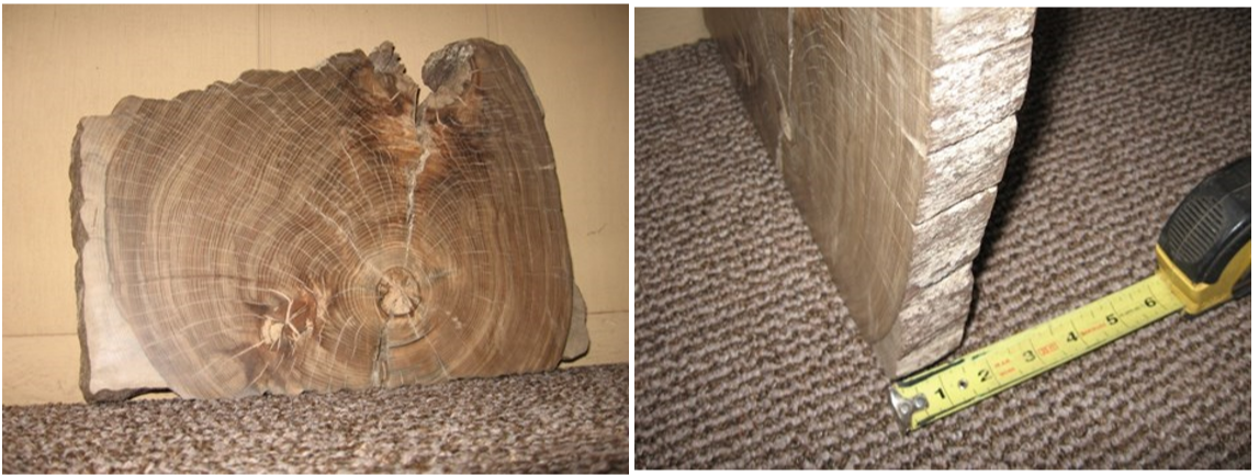
To carry out this study, Dr. Speer and Ms. Taormina were allowed to slice a 1-inch to 2-inch piece off the end of several of the timbers as shown in the picture.
The results from this analysis by Speer and Taormina were published in Tree-Ring Research, Vol. 72 (2), 2016:
“Through analyzing the wood anatomy, we identified eight different types of wood present in our 22 sampled logs. We sampled 11 American beech (Fagus grandifolia), five white oak group (Quercus subgenus Lepidobalanus), and one each from American elm (Ulmus Americana), winged elm (Ulmus alata), sugar maple (Acer saccharum), shagbark hickory (Carya ovate), white ash (Fraxinus Americana), and black walnut (Juglans nigra) [Table 1 in original publication]. Multiple species in the white oak group cannot be differentiated through wood anatomical analysis of the cross-sectional view so these samples are identified to the white oak group level.
“The beams were on average 32.65 cm (SD = 3.48) x 27.24 cm (SD = 1.74) in their x and y dimensions [Table 1 in original publication]. The tight distribution in the y-distribution suggests that they were hewn to a very specific height during their processing. We can tell that the samples were hewn because of the frequent broad axe marks along the outer surface of the beams. We sampled two beams that were double wide, which indicates the logs were not all hewn to a specific width or weight. Most of the beams were ca. 10 m in length with the eight beams towards the outlet of the culvert approaching 20 m in length [Figure 2 in original publication].”
Another finding of Dr. Speer’s analysis of the timbers was that the white oak timbers best correlation was to the Jefferson County, Indiana, area. The study also found that the white oak timbers were “likely cut in the early 1830s.” As often the case with canal-related questions, the answer to one question leads to another question. Were these timbers originally cut for another purpose? How were these timbers transported to the Vigo County location? Why is the white oak the only species not from the local area? What is needed for the answers to these questions is more timbers to take samples from. If you know of any Wabash & Erie Canal timbers for which permission to sample can be obtained, contact Sam Ligget (samuel.ligget@frontier.com).
Looking For Whitewater Lock #14
South Of Cedar Grove—
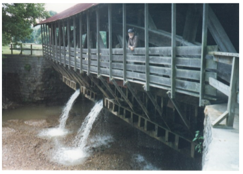
Spring Branch Culvert Destroyed
Paul Bischoff
I grew up on the bank of the canal in Cedar Grove, Indiana. Working with Julie Schlesselman of the Franklin County Library, we published a book early this month on the history of Cedar Grove. Obviously, there were several pages dedicated to the canal. My interest in this section of the canal remains high.
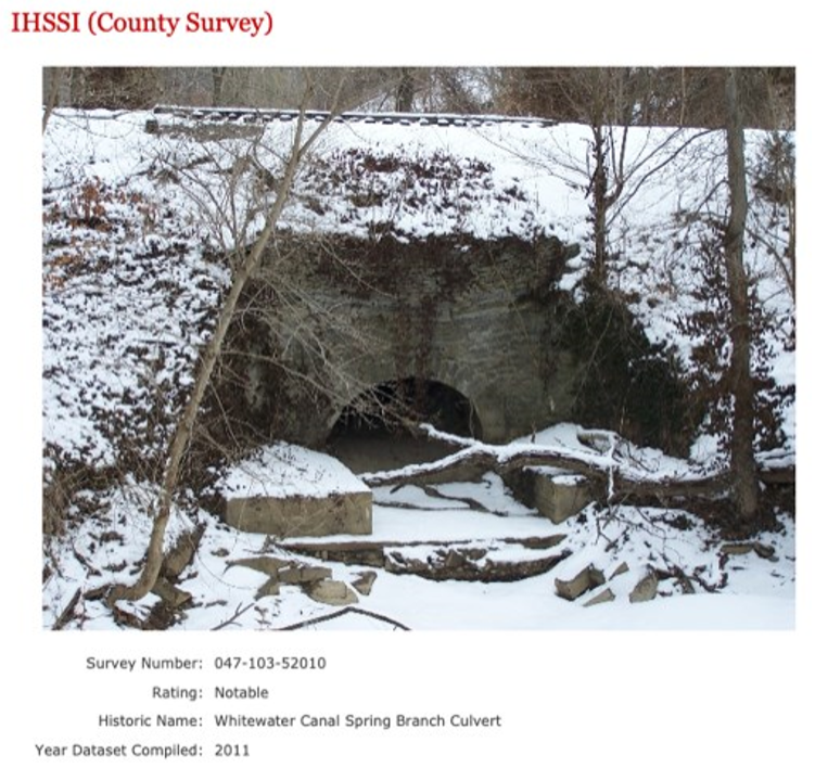
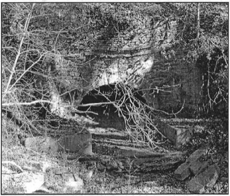
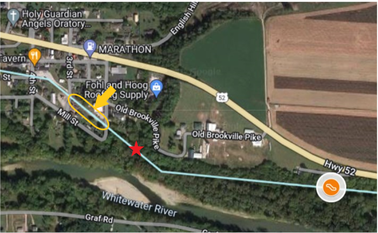
Earlier this week I was in town looking for the remains of Lock #14. I used the Spring Branch Culvert as a reference. Barring the use of ground penetrating radar, I am afraid I could find no evidence of Lock #14. I am sorry to report the Spring Branch Culvert is no longer standing. I found the attached photo online that makes me think it was still in good shape as late as 2011. I am also attaching a photo I took that shows only the foundation remains there today. It is not shown in my photo, but the RR tracks are still intact – hanging in mid -air and drooping a bit.
Has the Canal Society participated in doing research with ground penetrating radar? I am interested in finding the remains of Lock #14.
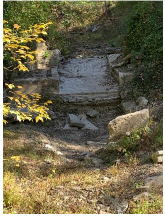
Photo by Paul Bischoff
There is a small oddly shaped house near Cedar Grove within five feet of the towpath. I speculate it was a staging area to load and unload canal boats years ago. I searched our county property and tax records to learn when it was built. Unfortunately, they do not keep tax records prior to 1990.
Are you familiar with buildings that served the canal boats? If I could find a good example or two, I may be able to confirm or deny my suspicion.
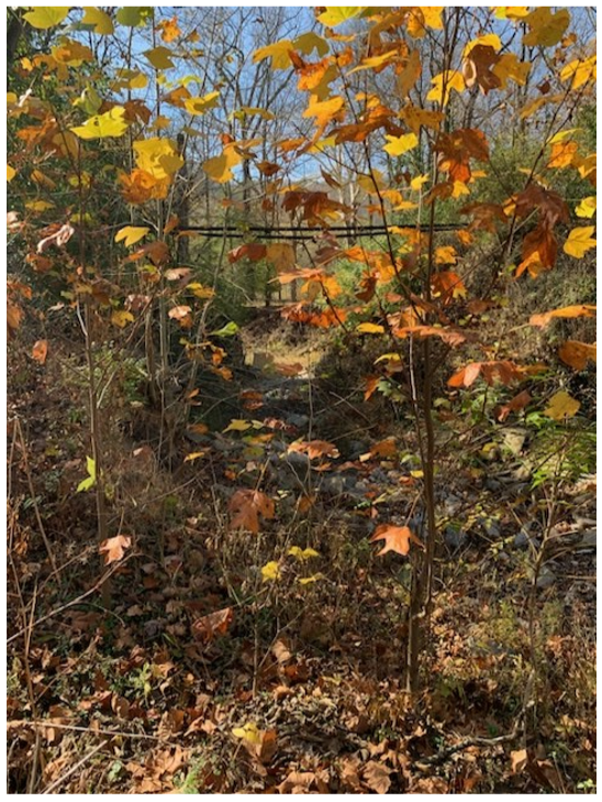
Photo by Paul Bischoff
When writing my book one of my sources on the WW Canal was written/published in 2006 by Donald Ray Burden for Ball State University: The Whitewater Canal-Historic Corridor Guide. I believe his sources were good and he personally did a field survey to verify what was still in existence. He did not find Lock #14. Therein begins my desire to find its foundation location with ground penetrating radar.
I have attached a couple items from Mr. Burden’s book which you may find interesting. I also am attaching a Word file in an effort to answer your location questions. (I don’t see the Sec #s as you requested.)
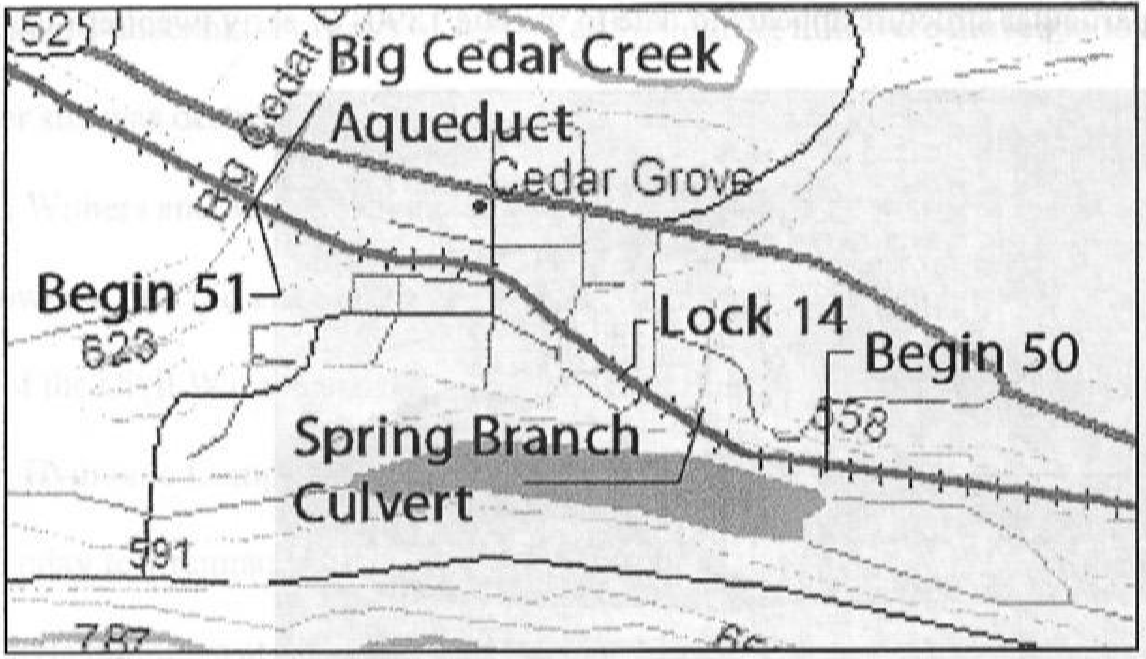
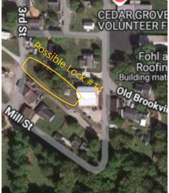
Through the use of the section plans found in Don Burden’s book I tried to determine the location of Lock #14.. In the screenshot below, I believe it is West of 2nd street in town.
Whitewater Canal Lock #14 Addendum
As I was putting this edition of the Tumble online, I read the above article from Mr. Bischoff about the location of Lock 14 and it got me to doing some more research. In his article he inquired about the use of ground penetrating radar (gpr) which is something I recently started using for locating graves at a local cemetery here in Gibson County. However, the distance from my location some 200 miles south west of Cedar Grove makes it a little difficult to drive there on a whim. That said I replied back to Mr. Bischoff about the use of LiDAR.
To those who know me know I thoroughly enjoy cartography and the latest tool that I have been using with success in locating canal structures has been Light Detection and Ranging (LiDAR). Unlike traditional United State Geological Survey topographic maps, which show changes in elevation greater than 10ft locally, LiDAR shows changes of 1 meter (39”) and greater. Indiana has LiDAR the entire state and it is available for public use for free. One of the easier things to find along any of Indiana’s canal route are locks, as they generally were greater than 3 ft. in elevation.
The Google Maps on the website are based on a combination of USGS maps and the maps I had available to me from previous CSI publications w/ the addition of LiDAR imagery. The problem is some of the structures are estimates and without people going out and locating physical evidence of said structure they are the best guess I have. I denote estimated structure locations on the Google maps with an asterisk on the table.
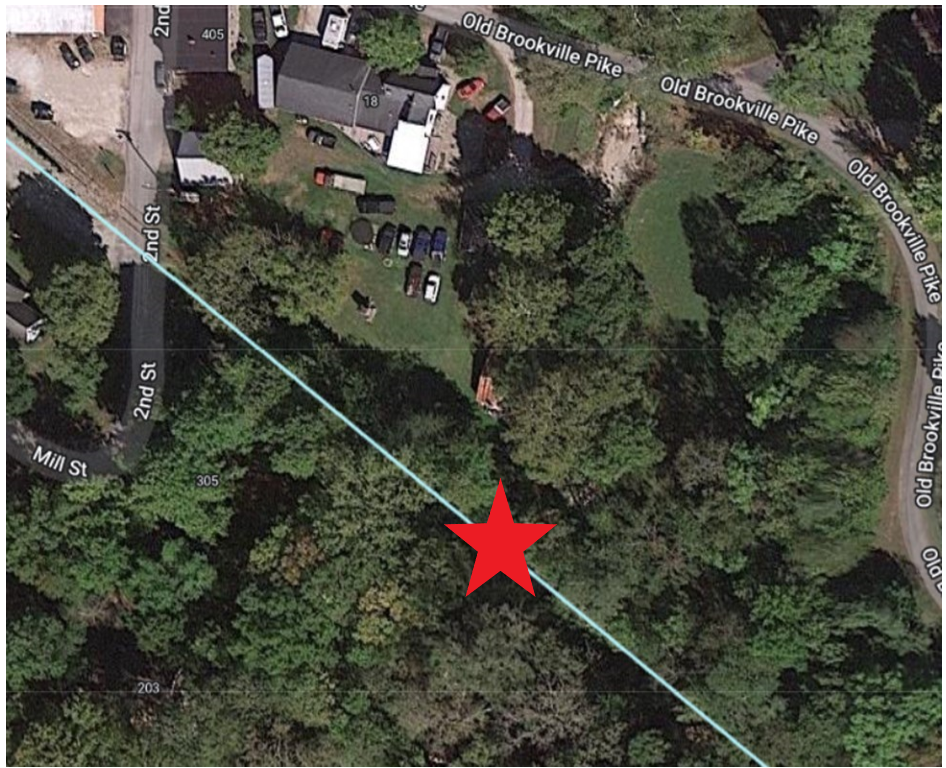
All this said, based on the information Mr. Bischoff provided that I read in this article I went to look at the LiDAR in hopes of finding something to help him in his search. Below are screen shots of the maps of what I found.
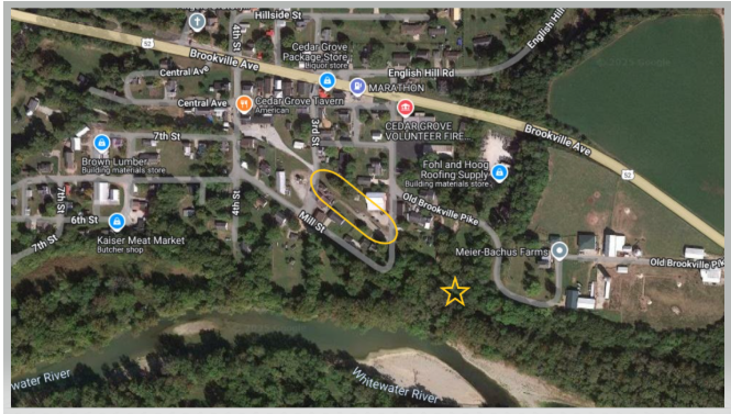
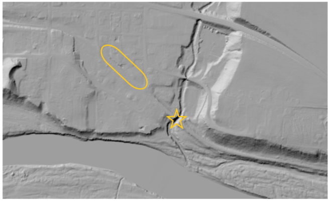
In the pictures above, the star represents the Spring Branch culvert location and the oval marks the location between 2nd and 3rd streets in Cedar Grove and the possible location of Lock #14.

As is the case with any remote investigation nothing can be confirmed until evidence is found at the site. I am hopeful Mr. Bischoff is successful in locating Lock #14.
A Cook’s Tale (1890)
Margaret Griffin
(First person presentation)
Hello there. This nice young man ( I think he must be a schoolteacher) has asked me to tell you about the Whitewater Canal that came through Connersville, not far from here. I’ll do the best I can.
Sarah Vroom Gonzales Sell
Let me tell you about myself, although there are many more important people than me who worked the canal. My name is Mrs. Sarah Sell. You can call me “Aunt Sally.” Little Lily and Florine Vinton used to call me that as they sat on the back steps of the daddy’s hotel in Cambridge City about a dozen miles north, waiting for our boat to come in. I’d bring them fresh bread, butter and jelly — oh, those were the days.
Well, back to the beginning of my story. My parents’ last name was “Vroom,” and they had come from Holland. My twin sister and I were born in New Jersey in 1827, but when we were five years old, my family moved to Cincinnati, Ohio. I grew up there, and married a man named John Gonzales. We had one son, Enoch, but my husband passed away and I had to make ends meet, so I went to work as a cook on a packet boat on the Miami and Erie Canal, between Dayton and Cincinnati.
Then I met Mr. Valentine Sell. He was born on a Pennsylvania farm and worked on a canal there. So that was his work in Ohio, too. He moved to Indiana where he had his own boat on the Whitewater Canal. It was called the “Aetna.” I came with him.

I worked as the cook on his boat, but I also worked a shift at the tiller, which guides the boat. I’m not ashamed to say I was the best tiller on the “Aetna.” Sometimes boats would race, but I never saw any fighting between boat workers like you hear about on other canals.
Now the “Aetna” ran between Cambridge City and Cincinnati in two-week round trips. Valentine always said that thousands of barrels of flour and a million pounds of pork were shipped from Cambridge City to Cincinnati by 1860! Whew!
The Whitewater Canal, it was something, too. It was part of a big plan in Indiana. I hear there were several canals planned in our state. One was from Toledo, Ohio to Evansville, Indiana, clear down the west side of the state to the big Ohio River. Another was to go through Indianapolis. They were all dug by men with shovels, some from other countries who answered advertisements for help we needed in America.
Congenial Vinton House host
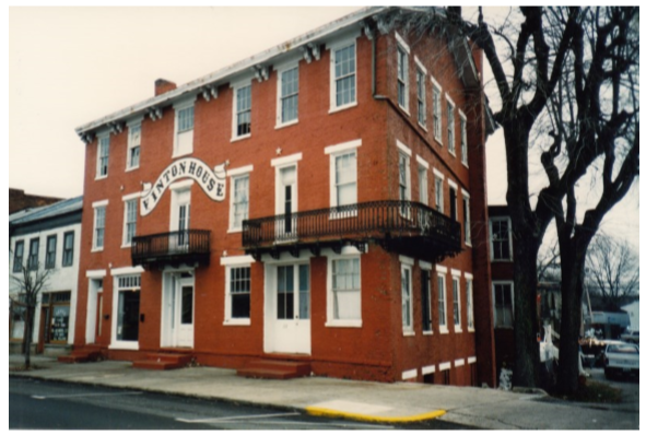
Vinton House Canal Basin on right
Photo by Phyllis Mattheis
The most northern part of the Whitewater Canal was at Hagerstown. The steady horses on the towpath pulled boats to Cambridge City, then to Connersville, Laurel, Metamora, Brookville, Harrison and Lawrenceburg. From Harrison they could also cross the state line to Cincinnati. Our friend Elbridge Vinton took over a beautiful, brick three-story rooming house in Cambridge City, where the canal made a turnaround in a wide basin.
The first part of the Whitewater Canal was finished from Brookville to Lawrenceburg in 1839. One thing about it was the big drop in the land going south, which caused flooding and damage to the dirt walls, the aqueducts, and the locks. We had locks to raise and lower the boats depending on which way they were headed. These were box-shaped and made out of stone. Locks on other canals were made of wood so they eventually rotted.
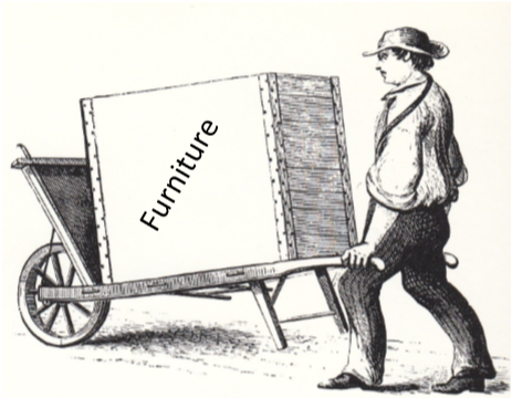

Our boat shipped a lot of things. I mentioned the flour and pork before. When we could, we hauled potatoes, beans, lard, flour, eggs and butter to Cincinnati. I know the importance of all those things — I use them in my cooking and baking. Sometimes we shipped furniture and leather. Also feathers and brooms.
Photo—Phyllis Mattheis
Water power from the canal was used for many flour mills and sawmills along the way. There were wooden aqueducts over some creeks, including Duck Creek at Metamora.
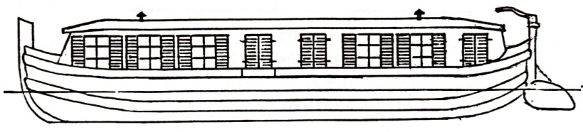
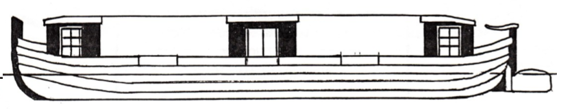
Oh — there were probably 50 boats on the Whitewater. Besides the “Aetna,” there was the “Native,” the “Patriot,” the “Belle of Indiana,” the “Banner,” the Favorite” and the Milton Torch Light.” They were big — about 14 feet wide and 80 feet long. Our boats were painted real pretty with the names on the bow. If our passengers stayed overnight, they slept in the long cabin. A curtain divided it, one end for men and the other end for ladies.
I heard of one young fella, name of Henry Shombre, who wrote down a diary of a four-day trip on the Whitewater. He said there was music and dancing, banjo playing, cards, blanket stealing and a lot of fun. His friends shot a goose on the way and had it for breakfast. Now that, of course, was on a packet boat, not a freight boat. Packets were for passengers. They carried the mail.
Drawing by Paul Baudendistel
Drawing by Paul Baudendistel
We didn’t have any bad accidents around here. My husband, Valentine, told me stories of long ago when he first worked on an eastern canal and the storms carried the boat miles and miles out into the ocean.
The Whitewater Canal only lasted about 20 years after it was finished. Its original cost and repairs to it amounted to two million dollars. I understand it never made as much as it cost, and was never open for more than four months at a time.
We kept our boat, the “Aetna,” running for awhile to Connersville in the 1860s. It was the last boat on the Whitewater, and then it sat on the ground between the canal and the river for many years. When the canal closed we finally got married in 1861, the year the Civil War started. The railroad bought the land and laid track on the north-south towpath across Indiana.
My husband has been dealing in horses since then. Some of them are harness racing horses. We have stayed on to live in Cambridge City. And my son, Enoch, lives in Cincinnati.
That four-foot river we called the canal brings back many good memories — hard work, good friends and many adventures.
CSI Member’s Milestones
Andy Olson
CSI member Andrew Olson of Glenview, Illinois was awarded the Willard C. Heiss Family History Genealogy Award by the Indiana Historical Society. The award is given to a family historian for his or her distinguished service and career in Indiana family history. This award helps genealogists discover connections between themselves and their ancestors through source material, family records and well-documented stories.
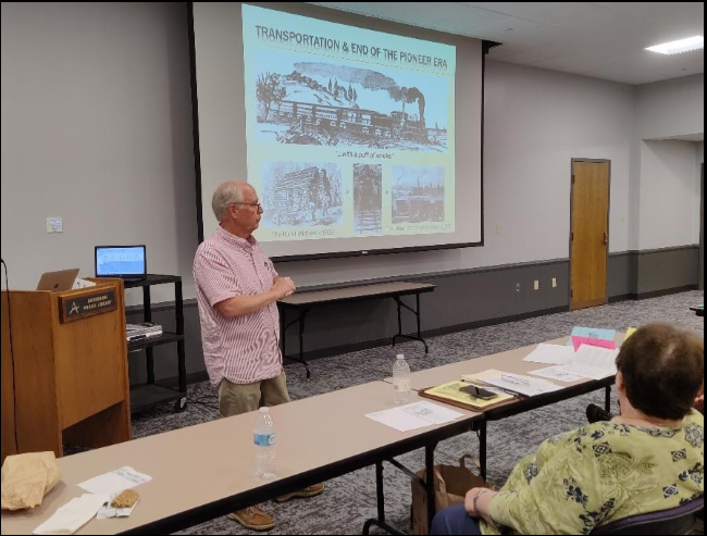
Andy “is a retired intellectual property attorney and an executive search consultant for top international firms in the telecommunications sector. Over the years, he has written several articles for IHS’s Traces and Connections magazines including “The 1818 Saint Mary’s Treaties” and “The History Behind Your Hoosier Genealogy,” featuring his ancestor David Kilgore. In 2017, he published Forging the Bee Line Railroad, 18481889. Additionally, he has given many presentations and written for various societies and institutions around and about Indiana history,” according to an article in the 2025 Jan-Feb issue of I N Perspective.
Andy shared the Kilgore genealogy with Canal Society of Indiana members in an article that can be found in The Hoosier Packet of October 2019. He also was a presenter at Indiana’s Old & New Central Canal and Transportation Symposium held in Anderson, Indiana on August 28, 2021. His PowerPoint program was entitled “Transportation and the End of the Pioneer Era.” A recap of this talk can be found in the November 2021 issue of The Tumble. David Kilgore’s biography can be found on the CSI website indcanal.org under biographies.
Vanished Indianapolis
Ed Fujawa
Ed Fujawa was recently notified that he was the 2024 winner of Nonfiction in Indiana for his book Vanished Indianapolis published in 2023. His book covers the many changes that have taken place in that city and the disappearance of many of its historic landscapes and structures. It has lots of information about the Central Canal and other sites that have either been lost to history or have been reused or repurposed. He has previously written several blogs about the Central Canal and followed its path in Marion county.
According to the announcement of the award, Ed was born in Boulder, Colorado, grew up in Greenwood, Indiana, and attended and graduated from Indiana University at Bloomington in 2004. He then left the state to attend law school returning to downtown Indianapolis with his wife in 2007. In 2008 they moved to the Butler-Tarkington Neighborhood.
Ed, an attorney with the Indiana Department of Insurance, specializes in medical malpractice litigation. His avocation as an Indianapolis historian is seen on his blog www.class900indy.com. He also enjoys fishing, photography and kayaking on Indiana’s waterways.
Repaired Central Canal Marker Dedicated
Ed Fujawa
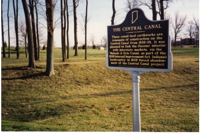
Indiana’s Central Canal, better known as the Indianapolis Water Company Canal, runs through the ButlerTarkington area of Indianapolis where Ed Fujawa lives. Ed notified Preston Richardt of an article in the Butler -Tarkington News, Winter 2024 Vol.69, No. 4 entitled “BTNA Assists With Repair and Rededication of Historic Marker For Central Canal.” It said the canal runs southwest through the neighborhood from Meridian Street and Westfield Boulevard to Newfields. It tells how the Central Canal is one of the best-preserved remnants of Indiana’s Internal Improvement Act of 1836, even though work was stopped on it shortly after the portion between Broad Ripple and downtown Indianapolis had been completed leaving sections like Alexandria, Anderson, and Waverly near I-69 and Highway 144 incomplete when the improvement program failed.
The portion of the Central Canal that was completed was valuable as a transportation canal for both commerce and recreation. Its waters were also used to power mills and turn the turbines of the water company’s pumping station, which is now in White River State Park, to push water through the city’s mains. In 1904 the canal began providing drinking water for the city and still supplies 50% of it today. This is all done through gravity flow from the canal.

April 2005 “Towpaths To Trails” tour
Photo by Bob Schmidt
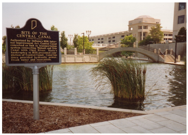
In 1966 for Indiana’s Sesquicentennial a two-sided historical marker for the Central Canal, which gave the same brief history of the canal on both sides, was placed in the Butler-Tarkington neighborhood. The marker was stuck by a car in 2016 and its pedestal destroyed. The marker itself was intact and stored at the Indiana Historical Bureau’s offices. Ed Fujawa worked with the Indiana Historical Bureau and Citizens Energy to reinstall the marker and hold a rededication ceremony. The BT Neighborhood Association paid for a new pedestal. The marker was touched up with paint, reinstalled and dedicated on November 26, 2024. Citizens Energy Group, which owns and manages the city’s water system, and Wilhelm Construction worked together to install the marker at Westfield and Illinois.
The rededicated marker is one of three on the Central Canal. The second one is at the canal basin next to the Indiana Government Center in downtown Indianapolis. The third is at a remnant of an unfinished part of the canal in Noblesville.
May 1997
Photo by Chuck Huppert
October 1999 “Tracking the Central” tour
Photo by Bob Schmidt
Moving West
Phyllis Mattheis, CSI director on the Whitewater Canal
In a casual conversation with a new friend, Lois Jordan, she mentioned that she found her great, great grandmother’s diary of the trip their large family made from western New Jersey to Ohio in search of a new place to put down roots in 1830. Previously, her great, great grandfather had made a separate trip to Michigan Territory looking for more farmland. He sent letters back to his wife with anyone he could find who might be going back east to New Jersey. As members of a Friends Community, they wanted to find another with like members, but as they set out, in 1830, they expected they would be led to the right place, not knowing where that might be.
As George Tatum mused about what he had learned, he came to the conclusion that northeast Ohio should be their destination, as it was already settled by several Quaker families. So, this couple, with nine children and all the belongings that they would need to ‘start over,’ traveled from the comfort of their Friends Community overland north to the Hudson River, where they boarded a boat for Albany, NY and the Erie Canal.
Everything was transferred to a canal boat to make the 363-mile eight-day trip to Buffalo. Both mother Lydia and a daughter Sybil kept diaries of their trip, which were preserved in a farmhouse attic trunk south of New Castle, Henry County, Indiana, not far from the Whitewater Canal. Four generations had lived at Maple Hill farm and preserved all kinds of family papers and pictures. The 1830 diaries had been handed down through six generations. Lois used the diaries to write the story of what it was like for her Tatum ancestors to travel west on the heavily traveled Erie Canal to finally settle in Salem, Ohio in a Friends Community, south of Cleveland.
She also writes about where each of the many family members lived and where they are buried. What courage it took for many families to consider traveling on the Erie Canal to new homes in the west!
The second edition of Lois Jordan’s 150-page book was published in 2020. Titled Journey by Faith, A Quaker Odyssey of 1830, it is available on Amazon and is an amazing story! The cover of the paperback is an 1829 watercolor entitled “View on the Erie Canal” by John William Hill and was provided by the New York Public Library. Continuing the story of the George and Lydia Tatum family who moved from New Jersey, using the Erie Canal to northeastern Ohio to settle in a Friends community.
More of the Tatum’s Family History
Phyllis Mattheis
Prepared in January 2025 from materials supplied by Lois Jordan, a descendant of the Tatum family.
Their son Lawrie, who bears his mother’s maiden name for his first name, was born on May 22, 1822 near Mullica Hill, New Jersey. Lawrie was 9 years old when his family made their trip, using the Erie Canal, to resettle among other Friends in northeastern Ohio. When he was 22 years old in the summer of 1844, he set out for the territory of Iowa. He returned to Ohio to marry Mary Ann Dean in February 1848 and took her back to Iowa, where they raised four sons and one daughter. Tatum was active in the Society of Friends and helped to establish the Red Cedar Meeting.
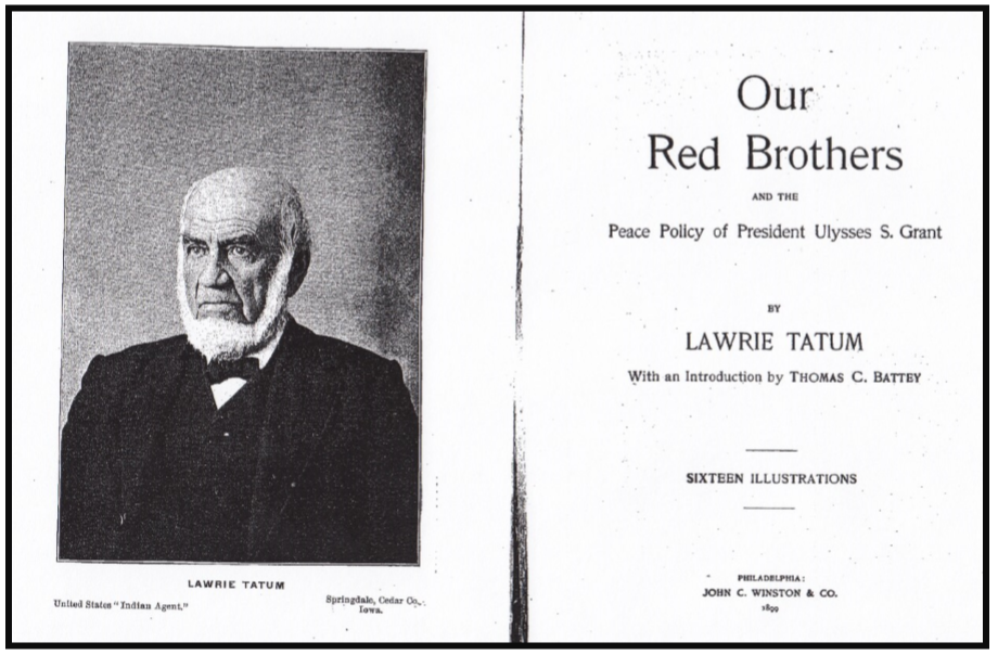
In 1869, under President Ulysses S. Gant’s policy of selecting Quakers to fill various Indian Agency posts, Tatum was chosen to serve as Indian Agent among the Comanche, Kiowa and Apache at Fort Sill in Indian Territory (Oklahoma). Tatum remained in this post four years until March 1873. His experiences there provided the material for his 366 page book, Our Red Brothers, published in 1899. In it he details the amount of government and church monies spent to educate and Christianize Indian tribes in the west, and the resulting successes and failures after having built boarding schools and houses and government buildings and plowing hundreds of acres to teach farming. In 1872 the number of Indians was estimated at 350,000 and the area of land they occupied was estimated as nearly the size of France. That same year Congress forbade the making of any more treaties with them. There were 59 Indian agents appointed by the president, and 17,000 Indians were placed under the charge of Friends, with 100 teachers, clerks, farmers, smiths and other employees.
Later, Tatum was chosen to be the guardian of the three orphaned children of West Branch residents Jesse and Hulda Hoover—Theodore, Mary, and Herbert, a future USA President. Tatum maintained records showing how the funds from their parents’ estates were spent on the children until they each came of age in the 1890s. Lawrie Tatum died at the age of 78 in Springdale, Iowa on January 22, 1900, shortly after his book was published.
The Herbert Hoover Presidential Library maintains a collection of Tatum’s papers and documents, records, correspondence, diaries, photographs, postcards, and writings by and about Tatum, including a Pendle Hill Pamphlet of 27 pages, titled ”Lawrie Tatum, Indian Agent; Quaker Values and Hard Choices,” printed in 1981.
Two other of Tatum’s siblings were important. Rebecca (1819-1902) was married to the first president of Earlham College and David (1823-1912) became a recorded Friends minister and temperance crusader. Earlham College in Richmond, Indiana, also has a collection of Tatum papers that is open to the public.
We sadly remember how the canals of the Midwest were used to move settled Indians from their established homes in Ohio and Indiana to the far west onto Indian reservations.
Whitewater Canal Article
Preston Richardt found a story by Anahid Akkam entitled “A Road Along Indiana’s Prettiest Canal And Several Small Towns Must Be The State’s Best Scenic Drive” on Islands.com . It was all about experiencing history and nature along the 78-mile route of the Whitewater Canal Scenic Byway. It gives a short history of the canal and says the Byway was established in the 2000s. It tells how you can visit some of the canal’s tunnel arches (culverts), feeder dams and Duck Creek Aqueduct while taking in views of towering trees, rolling hills and farmland.
The drive begins at Metamora, heads down toward Brookville, then toward Laurel passing by Connersville, Cambridge City and ends in Hagerstown. It pictures the gristmill at Metamora, the courthouse at Brookville, and a row of colorful buildings in Connersville. The first stop is at the Whitewater Canal State Historic Site to see how people manufactured cornmeal and flour. It talks about the Federal and Greek Revival-style architecture found in Brookville with its nearby 5,260 acre Brookville Lake. It tells about the canal feeder dam at Laurel, which is one of seven on the canal. The Whitewater Valley Railroad is located at Connersville and takes visitors 19 miles down its track to Metamora and back. If suggests visiting the National Road Antique Mall in Cambridge City and the Overbeck Pottery Museum at the city’s Public Library. Wine is available at the Pilgrimage Wine Company. It completes the tour visiting Abbott’s Candy in Hagerstown for special chocolates, seeing the frescoes by Charles L. Newcomb at the Hagerstown Museum and Arts Place, and soaking up nature in Steve Swoveland Nature Preserve.
Canal Timbers In Storage Room
Tom Castaldi, CSI Director, Ft. Wayne
This past week I, Tom Castaldi, got into a conversation at the post office with a fellow wearing a Fort Wayne Country Club sweater. I mentioned the downstairs Canal Room at the Club and meetings I had attended there. He said now it’s used as a storage space. I told him that the woodwork in that space came from a genuine Wabash & Erie Canal structure. He was surprised to learn of the historic connection and my great disappointment.
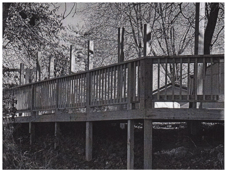
Delphi Builds Boardwalk To Bayou
From “Currents” November 27, 2024, Wabash & Erie Canal, Delphi, Indiana
The Carroll County Wabash & Erie Canal Association is building a boardwalk with exhibits that will take visitors back in time to the period just before the Wabash & Erie Canal began operating in Delphi. This boardwalk along the Delphi Bayou will have new exhibits that focus on the following three topics:
- Native American presence in the Wabash Valley in the 1800’s
- Early white settlement in the Wabash Valley
- Canal construction in this unique geological zone
Across from the Wabash & Erie Canal main boat dock in Canal Park the entrance to the boardwalk is taking shape due to the hard work of Mac Carlisle and the Monday-Wednesday-Friday Volunteer Crew. A planning team has been researching and designing the exhibits, which, when completed, will engage visitors outside the Canal Interpretive Center with educational fun. The following are members of this team:
- Dan McCain (Canal Park president emeritus)
- Janet Ayres (Canal Park board president)
- David McCain
- Dr. Chris Moore (archaeologist with the University of Indianapolis)
- Len Mysliwiec (designer of the award-winning Wabash & Erie Canal Museum and its exhibits)
- Mac Carlisle
- Terry Lacy (artist who has created many original works for Canal Park)
- Becky Crabb (Canal Park programs chair)
- Tom Castaldi (Allen County historian and author of many of Canal Park’s interpretive panels)
- Plus, some others who can join along the way.
Funding for this exciting project is in part through a grant from the Wabash River Heritage Corridor Fund administered by the Indiana Department of Natural Resources, Division of Historic Preservation and Archaeology.
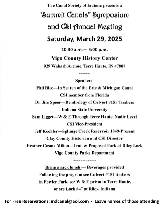
“Summit Canals” Symposium
or
you can use the link below to reserve your spot.