

Index:
Here Comes The Circus
By Carolyn Schmidt
Circuses were a part of the canal era. At that time roads were few and far between and were an iffy way of transporting them when their wagons bogged down in the mud or directional signs were changed by mischievous boys. Also some cities in the eastern states would not tolerate circuses thinking they were not in good taste and the performers unrefined. In 1838 a New York historian actually thanked the public that “neither theatre nor circus can now be found in Rochester.” In order to circumvent these problems, savvy circus owners turned to North America’s canals to reach small towns along their banks where citizens were clamoring for entertainment.
Probably the first circus to travel by canal boat was Sig Sautelle’s Circus owned by Sig Sautelle. Born George C. Satterlee or Satterly on September 22, 1848 near Glens Falls in Luzerne, New York, he was the son of a shoemaker. During the Civil War, George, at about age 14, joined the Union Army as a drummer boy. While serving in this capacity he met and was fascinated by a ventriloquist, who taught him the art and magic tricks. Returning home after the war he worked as a printers’ devil for a while and then in a Wagon Wright’s shop in Saratoga, Glens Falls and at Ft. Edward. These jobs gave him a solid foundation for his future.
George met Ida Belle Travers while at Ft. Edward. She was so impressed by his ventriloquism and magic tricks that she encouraged him to become a showman. He began studying Punch and Judy shows, took what he learned from them and created his own traveling puppeteer and magic show. He was 24 years old when he purchased his first wagon for $6 dollars, a blind horse for $13 and a harness for $4. He married Ida Belle, who managed his finances while he managed the show. They began their life traveling from town to town much like a grasshopper hops from place to place. People began calling him Sauterelle, which means grasshopper in French. He liked it and thought that if he changed his name to something more exotic it would draw greater audiences.
George also worked as a side show performer for Stowe‘s Great American Circus and Barnum and Bailey. As he became more popular, he wanted a larger show He decided to become Signoir Sautelle. He was a rather tall man with a long, drooping, handlebar mustache. His big blue eyes belied that he was of Latin descent so “Signoir” soon was shortened to just “Sig Sautelle.” At age 34 he opened Sautelle’s Parlor of Fun and Dog Circus. After being badly bitten by a dog, he went back to being a side show performer with the Gregory Brothers’ Show.
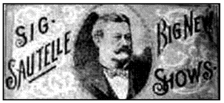
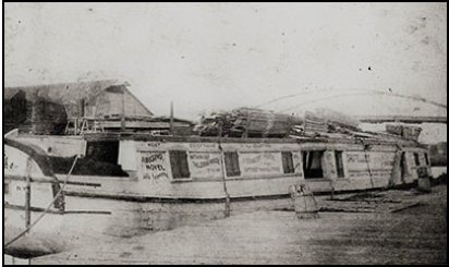
In 1885 at age 37, George, now “Sig,” finally broke away to create Sig Sautelle’s Big New Shows. He decided to transport his circus by canal boat but knew that the low bridges would not accommodate the height of circus wagons. He used his experience in the Wagon Wright’s shop to have special wagons built using short spokes in the wheels making them low enough when placed on a canal flatboat to pass under the bridges. His first boat, the “Belle,” was named after his wife. Each side of the boat had paintings of circus acts, clowns and wild beasts that resembled the Ringling & Barnum Circus billboards. The “Belle” contained very comfortable living quarters for the performers according to a Jewish boy, who was paid $4 per week. Its luxurious dining room seated over 100 people. Sig and Ida Belle lived on this boat for a number of years.
Transporting his circus up and down the Erie and Oswego canals on the “Belle” was so successful that a few seasons later he purchased a second canal boat, the “Kitty.” It may have been named after the cat band that he had at times. The cats were operated like marionettes from strings attached to their paws and they beat drums. This boat was for the animals, wagons, and other circus paraphernalia. Both of Sig’s boats were 88 feet long and 12 feet wide. Sautelle’s Canal Circus visited towns along the banks of the Erie, Chemung, Champlain and Seneca Canals of New York for five years, 1882-1887. During the winter month’s the boats docked at Syracuse. While frozen in the Erie Canal, they were used as lager saloons.
Sig’s circus was often called “the Sunday School Circus” since it was so clean. Although it was first transported by canal boats, as the roads became better he used circus wagons for a while to travel further inland. As railroads improved he loaded the wagons onto rail cars and later used motorized trucks.
Sig became quite wealthy though only charging 25 cents for adults and a dime for children throughout his half-century in the circus business. In 1900 he moved to Homer, New York and purchased two hotels to house his employees. Two years later he built a circular-shaped, ring barn in which he trained horses and circus acts during the winter months.
However, prosperity did not last for Sig. In 1904 his wife, Ida Belle, had a stroke, which kept her from keeping up with circus life. Sig returned to Homer to care for her and sold the circus that year. After Ida Belle’s health improved, Sig became partners with Oscar Lowande and George Rollins. They started a new circus in 1911. Unfortunately Sig had to sell his share of this circus to Danny Robinson in 1913 when Ida Belle had a second stroke and he had to return home. In 1914 Sig declared bankruptcy. He was unable to pay his property taxes due to high medical costs. In 1916 Ida Belle passed away.
Sig held a variety of jobs until 1927 when he once again formed a new truck show. It failed within the first year.
George C. Satterlee alias “Sig Sautelle” died on June 21, 1928. Canals had played an important role in his life.
“Dan Rice” was another circus man who transported his circus by canal boats. Born Daniel McLaren on January 23, 1823 in New York City, he was married at age 17 to Margaret, “Maggie.” They had two daughters, Catherine and Elizabeth. He and Maggie joined a traveling puppet show in 1840 and in 1841 performed a comedy pig act called “Lord Byron,” with a trained pig named Sybil. Sybil could do an number of tricks and could tell time. He was paid $4 a week for the act.
From there he began dancing and singing, sometime in blackface if singing a “negro song.” Dan was a great clown but different from most clowns in that he mixed jokes with “solemn thoughts and civic observations.” He also trained animals, wrote songs and performed political satire.
He joined Spalding’s North American Circus in 1844 and was such a hit that Spalding started Dan Rice’s Circus in 1848. But Dan tired of working with Spalding and started his own circus touring the New England states by wagon and going all the way to New Orleans by river barges. When Zachary Taylor was running for president in 1848 Dan invited him to campaign on the circus bandwagon. This resulted in the expression “jumping on the bandwagon.”
Dan’s circus was so popular that by 1853 he operated a fleet of canal boats called Dan Rice’s Museum and Menagerie through Indiana, Ohio and New York. He appeared at each exhibition in which he mixed animals, acrobats and clowns.
Although popular with almost everyone. Dan had his detractors. When a Methodist minister attacked his circus from the pulpit, Dan said it was the best publicity he could receive.
He wintered his circus in Girard, Pennsylvania. There he divorced his wife Maggie in 1861 and on November 4 of that year married Charlotte Rebecca McConnell on her 18th birthday. He was 38 years old. In 1862 Dan and Charlotte had a daughter Lottie, who tragically died six months later. Their son Dan Rice Jr. was born in 1868.
During the Civil War 1861-1865 Dan was closely watched to see if he had allegiance to either the North or the South since his circus performed in both northern and southern states. Following the war he assisted both sides by financially funding the rebuilding of Southern schools and churches and supporting the Northern troops’ widows and children. He became so popular that he ran for President of the United States in 1868. However, he soon dropped out of the race as he had done earlier when running for the Senate and Congress.
Dan coined the terms “One Horse Show” turning a derogatory remark made by his competitors about his early circus having only one horse into an expression meaning to put on a good show. When his circus troupe was attacked by a mob in New Orleans in 1848 he yelled to his friend Reuben, “Hey Rube.” The term “Hey Rube” became a circus call for help in a fight. Also his circus was praised in an Arkansas paper as “The Greatest Show on Earth” long before Ringling Brothers: Barnum & Bailey ever used the term.
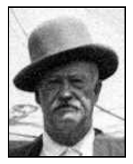
Dan also performed parodies of William Shakespeare’s works. There was Dan Rice’s Version of Othello and Dan Rice’s Multifarious Account of Shakespeare’s Hamlet. He used a variety of dialects. He changed from a circus clown to a gentleman often showing inklings toward the Democratic party in his vaudevillian styled shows. Being very patriotic he influenced men like George M. Cohan. He is said to be one of the main models for “Uncle Sam” with his long white goatee.

After seeing Dan perform in Hannibal, Missouri, Samuel Clemens, “Mark Twain,” was so impressed that he described a circus in the Adventures of Huckleberry Finn. Dan was also loved by Walt Whitman and many newspaper publicists.
Dan and Rebecca were divorced in 1881 so he did not return to Girard. He began drinking heavily as his fortune decreased.
Dan McLaren, “Dan Rice,” died penniless of February 22, 1900 in Long Branch, Monmouth county, New Jersey. He was buried in a cemetery located there.
After his death Dan was inducted into the International Circus Hall of Fame in 1962 and the Sarasota Circus Ring of Fame on January 29, 1994. Each year Girard, Pennsylvania holds the Dan Rice Days Festival on the first weekend in August. A monument to him stands in Girard.
There were other canal circuses. They often hired seasoned canal boatmen such as Mike Coyle, a canal boat captain in Buffalo, New York, who was known as the “terror of the towpath,” and Charlie Castle, who joined Dan Rice.
In 1853 and 1854 Levi J. North and Harry J. Turner ran a canal boat show and during the winter season leased the National Amphitheater in Philadelphia. In 1858 and 1859 North’s National Circus was on the road. Then in the summer of 1860 he ran a canal boat show and in the winter played a star engagement with Spalding and Rogers at the Bowery Theater in New York.
Following the Civil War better roads and railroads led to the demise of canal circuses. However, for more than 15 years the circus reached many towns along the old canal towpaths.
Sources:
Carlyon, David. Dan Rice: The Most Famous Man You’ve Never Heard of. 2001.
Chindahl, George Leonard. The History of the Circus in America. 1959.
Day, Charles H & William Lawrence Slout. Ink from a Circus Press Agent: An Anthology of Circus History. 1994.
Fort Wayne Sentinel, June 24, 1843 and September 23, 1843.
Guinsburg, Lawrence M. Tales of and about Jewish Youth During the Fin-de-sieck Era. 2010.
Kotar, S.L. & J.E. Gessler. The Rise of the American Circus 1716-1899. 2011.
Poinsatte, Charles R., Fort Wayne During the Canal Era 1828-1855. Indianapolis, IN: Indiana Historical Bureau, 1969.
Walker, George William. Chips and Shavings: Stories of Upstate New York. 1966.
Zimmer, Melaine. Sig Sautelle The Circus Man (Central New York and the Finger Lakes) Myths, Legends and Lore. 2008.
Roaming the Carolinas
By Mike Morthorst with photos by Tom Morthorst
In August of 2018 I. Mike Morthorst, took a trip with my brother, Tom, on one of my typical vacations. By that I mean there was no primary destination in which most of the vacation time was spent at one place. Rather there were about a dozen destinations in a particular area that by themselves would not merit a trip but could be combined into an interesting whole. Almost by accident while on this trip we stumbled on two extremely interesting canal sites.
The trip’s origins date from when I read that the Airbus A-320 airliner which was miraculously landed by US Airways Captain Sullenberger in the Hudson River in 2009 was now the main attraction at an aviation museum at the Charlotte, North Carolina International Airport. A problem developed immediately when I obtained a copy of the official Charlotte Guide which said the airport museum contained the plane used in the motion picture. Since I was not interested in seeing a movie prop, some further checking was necessary. I eventually concluded the actual plane was there. At that point a trip started to come together.
With the general destination as North Carolina, other of that state’s attractions were included. Since my brother is a railroad fan the North Carolina Transportation Museum at Spencer and the Saluda Grade (the steepest railroad grade in North America after Madison Indiana, where the CSI famously got lost with my help on the grounds of a mental hospital one Sunday morning many years ago) were added. My interest in railroads centers on train stations. I discovered there were Fellheimer and Wagner designed stations in Winston-Salem and Greensboro, North Carolina. These are the architects who designed the impressive Union Terminal in Cincinnati, where I live. In the last few years I have been visiting their various works. Their largest station, Buffalo, New York Central Terminal, was toured in 2017. I have also been to this firm’s stations in Utica, New York; South Bend, Indiana; Erie, Pennsylvania and Hamilton, Ontario in Canada. I was really curious what some of their smaller stations were like. We also included a famous small wooden station in Hamlet, where two mainline railroads intersected. I also wanted to visit the birthplace of President James Polk, southeast of Charlotte, who is a politician I admire. He is a President who actually kept his promise of serving one term in office. During that one term he added the western one third of the United States to the country’s total area. Tom wanted to see the battleship North Carolina (BB-55) at Wilmington so that was included. We decided to go to the Revolutionary War battlefields at Cowpens and Kings Mountain, and we both wanted to see the Linn Cove Viaduct on the Blue Ridge Parkway, which is basically a giant S-Bridge.
At that point we had a pretty interesting trip. Rather than take Interstate 75 to points south I opted for US 23, which is a four lane divided highway through the eastern Kentucky mountains and the western Virginia panhandle. It becomes Interstate 26 in Tennessee and the Carolinas. On the Kentucky-Virginia border is located Breaks Interstate Park, considered the largest canyon in the eastern United States. I had visited there about twenty years ago. On that day so long ago the canyon was completely filled with smoke from a nearby forest fire and nothing could be seen. Also along the US 23-I-26 route parts of the Clinchfield Railroad can be viewed. This is one of the great super railroads of the early 20th century. It runs from Elkhorn City, Kentucky to Spartanburg, South Carolina. As built it did not go around mountains or streams, it went through or over them respectively. The line is mostly on one elevation and features very mild curves and elevations. A number of its bridges and its many tunnels are quite dramatic. When I was there twenty years ago it was full of long coal trains. Due to the decline of the coal industry, there now are none.
We left on the trip the week of August 20th, which turned out to be three weeks before the area where we were going was devastated by Hurricane Florence. We got to Pikeville, Kentucky the first night. Throughout its existence, Pikeville was been located on an oxbow of the Big Sandy River and was constantly ravaged by flooding. In the 1980’s the river, the CSX railroad and US23 were relocated to a newly dug trench through Peach Orchard Mountain, which had formed the oxbow. The result is spectacular. Pikeville now has room to grow and is free from flooding. In college my brother had played Pikeville University in basketball and only knew the place prior to the changes. Twenty years ago when I was last in the area, the project had just been completed and the river that was around the downtown was being filled in. We both felt the changes since we were last there were remarkable.
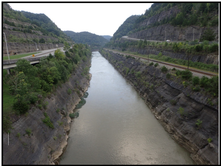
On the second day I finally got to Breaks Park and got to see what it looked like with no smoke. It was magnificent. The gorge is 1400 feet deep and five miles long. The previously mentioned Clinchfield Railroad is situated on the canyon floor. We continued along US 23 and made an unplanned stop at Natural Tunnel State Park, where a Norfolk Southern rail line is routed through a natural bridge rock structure. We then continued into North Carolina, and Ashville. It has become a tradition whenever I come to Ashville to consider visiting Biltmore, the large Vanderbilt Estate. Also part of that tradition is, after checking the price of admission and noting that it is even worse than the last time I was there, it gets skipped. This time was no exception.
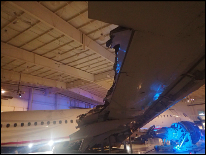
On the third day we explored the Saluda Grade. It is much longer than and not as steep as the one at Madison but still impresses. We then visited the Cowpens National Military Park but had to skip Kings Mountain as we found a Charlotte Airport museum flyer at Cowpens that stated the museum closed at 4:00 pm (for some inscrutable reason). The airliner at the airport was indeed the one involved in the river landing. The news reports of the time showed the plane to be relatively intact after it landed in the river. The plane in reality was quite torn up, almost in shreds, on the part that made the belly landing. It was quite sobering to see how thin and flimsy the metal on these planes actually is. One wonders if it makes sense to ride on these things.
Thanks to the eccentrically early hours of the aviation museum, we had lots of time after that visit to enjoy driving in rush hour through the Charlotte metropolitan area (current metro population: 2.5 million). We headed to Polk’s birthplace. Due to traffic it was a relatively long trip. The interesting fact is that before Charlotte started to grow by leaps and bounds, the Polk site was far in the country. Now it is part of the metropolitan area. We managed to arrive there just before it closed, but still had time to visit the attraction. Checking the map (I still prefer to use paper ones), I noticed a “Lansford Canal State Park” over the border in South Carolina, about 20 miles south of the Charlotte Beltway. I could not find much about it in the materials I had with me, but I did know how to get there. So off we went.
The Landsford Canal was part of a massive river navigation system consisting of three waterways designed to extend from Charleston South Carolina to settlements in the interior of the state. All three of these waterways branched off of the Santee Canal, which was a larger canal that connected Charleston to Columbia and was completed in 1797. The Santee was the idea of engineer Robert Mills, who dreamed of a Charleston-Mississippi River canal. That never happened. The Santee became the southern part of the route common to all of the waterways from the north. The part of the route common to all the waterways followed the Cooper River out of Charleston to Moncks Corner. There it entered the Santee Canal, the first practical canal built in America, and unusual in that it was a summit level canal. Due to its being a summit level canal the prism of the canal was 35 feet wide at the top and 32 feet wide at the bottom with a depth of four feet of water. The locks also were smaller, being 9.5 to 10 feet wide, with 60 feet between the lock gates. These dimensions were reduced in order to save on water used, since there were limited water resources on summits. The canal continued 22 miles to the Santee River. At that point there were connections to Columbia, the state capital. The part of this system, below Columbia, was able to handle small steamboats. The remaining three interior waterways built north were built to handle only bateaux.
The Landsford Canal was part of the easternmost system, which followed the route of the Cooper, Santee, Wateree and Catawba Rivers into the interior. Charlotte, having been founded in 1768, was not involved in this waterway as it was a very small community of a few hundred people at the time of this canal era. Additionally, the Catawba River did not go through Charlotte, passing 10 miles to the west, midway between it and Gastonia. South Carolina was the most active of the southern states when it came to canal construction. In addition to the Wateree-Catawba Waterway, similar waterways with bypass canals including locks were built on the Broad River, roughly in the middle of the state, and the Saluda River, on the western side of the state. The total length of this waterway navigation system was a remarkable 1400 miles.
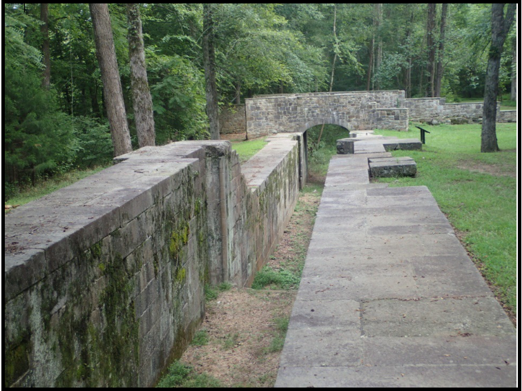
The “Landsford Canal” is one of four bypass canals built past obstacles on the Wateree and Catawba Rivers, such as rapids, shoals, and small waterfalls. These canals were constructed much later than the Santee Canal, from 1820 to 1828, and the construction was performed by slave labor. The other bypass canals were the Wateree Canal, the Rocky Mount Canal, and the Catawba Canal. The total system had a short life, being out of business by 1852.
The Landsford Canal is a two mile long bypass canal, avoiding shoals on the Catawba River. It is the northernmost canal of the four such bypass canals on the river and is located about 13 miles southeast of Rock Hill, South Carolina. One would take US 21 from Rock Hill, with a turn east on SR 327 at Rowell to the park. The canal features what is described as the best preserved canal structures in the South. It has five granite locks in three structures, two being double locks. Each lock measures 10 feet wide by 80 feet long with a 9 foot lift. One lock structure in particular, the middle one (Locks 2 and 3) features a unique stone arch bridge over the lock chamber. It bears and inscription: “Robert Leicke/Contractor 1823.” Leicke was later Superintendent of Masonry on the C&O Canal. The stone bridge was intended for use by traffic that crossed the river by way of “Land’s Ford” located just east of this lock. Thomas Land owned the land on which the canal was built and he operated the ford at the site.
Very little of the stone locks and structures of this system remain for viewing today. Beginning in 1939 South Carolina constructed a massive artificial lake system which flooded most of the rivers and the Santee Canal. The three bypass canals south of the Landsford are all under water, the result of the construction of smaller artificial lakes. A stone lock house from the Rocky Mount Canal, all that remains from that location, has been moved to the Landsford site.
The state park as it exists today features two large parcels of land on each end located at the junction of the canal with the river, with a much narrower section between them and containing the canal. Most of the remaining canal/navigation system in this part of South Carolina is underwater in many of the state’s recreational lakes.
After visiting Landsford we headed northeast to Spencer and the North Carolina Transportation Museum. After a somewhat terrifying ride through downtown Charlotte in the dark while on the under construction I-85, we eventually arrived at Spencer. We visited the museum the next day. Basically the “Transportation Museum” is primarily an extensive and excellent railroad museum. The facility was the main repair facility for the Southern Railroad in this part of the South. Since its creation, the museum has been attempting to supplement its railroad collection with rare vehicles and automobiles such as an Edsel, a Studebaker, a Corvair pickup truck, a Nash Ambassador, a covered wagon, farm wagons, and a horse drawn buggy. On the aviation side there is a DC-3 from Piedmont Airlines, which was founded at the nearby Charlotte Airport. One can also see a replica Wright Flyer aircraft, and various smaller planes. It takes almost a day to see what there is to see.
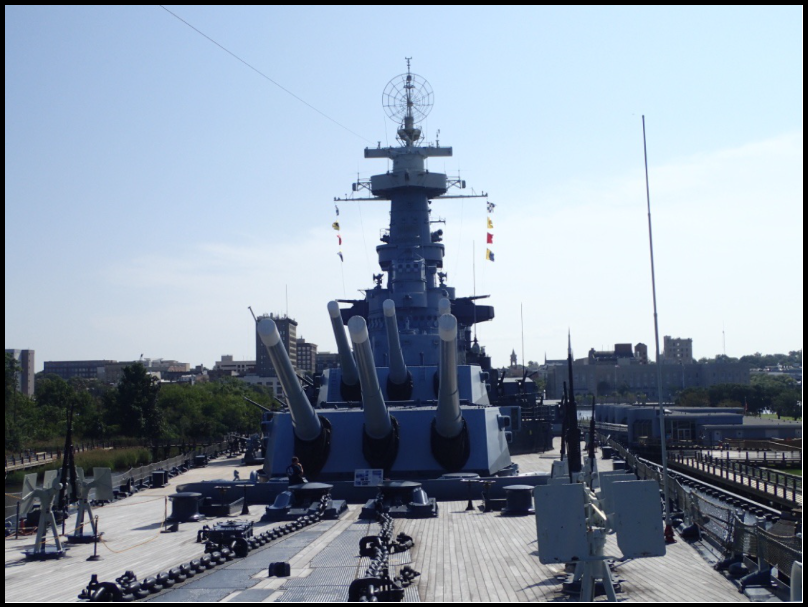
From Spencer we headed toward Wilmington to see BB-55, the USS North Carolina battleship, which is moored in the Cape Fear River harbor on the south side of town. On the way there we took US74/I-74, which is one of two places in the United States that a US highway and an Interstate Highway share the same route number. The other one is US 41/I-41 in Wisconsin. The North Carolina was the first of the ten fast battleships built just before and during World War II. It featured a primary armament of nine 16 inch guns and a secondary armament of twenty 5 inch guns. After retirement it became one of the first ship memorials established around the country. If you are tall the tour can be something of a challenge.
At this point we began to head back toward home. On every map of North Carolina I had seen in recent memory there was a location about forty miles northwest of Wilmington along State Route 11 which caught my attention and in my mind merited a stop. It was “Lock No. 1” along the Cape Fear River. “Lock No. 1” appears on almost all maps of the state, with some maps showing a “Lock No. 2” further inland. The state of North Carolina had been attempting to build navigation improvements along this river since 1792, both north and south of Fayetteville. Three companies were chartered by the North Carolina Legislature in the early nineteenth century with only the third one, created in 1815, showing any progress. This company sputtered along until 1859, having abandoned building the navigation north of Fayetteville in 1834. The project featured poor engineering, mismanaged finances and crumbling structures. A channel of sorts was opened below Fayetteville. Steamboats were usually able to navigate the river when water levels permitted. A fourth company chartered in 1859 finally succeeded in 1860 building the navigation below Fayetteville. A competent and honest chief engineer had been found who got the project in shape. Unfortunately severe flooding wrecked the waterway in 1861. An exasperated state legislature finally gave up on further navigation improvements at that point. The availability of railways was another contributing factor to this decision.
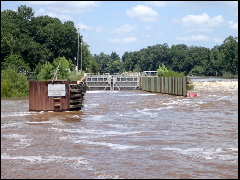
In 1915 the US Army Corps of Engineers began constructing three dams in order to open up a nine foot slack water channel to get commercial barges from Fayetteville to the Atlantic Ocean. The lock chambers are 200 feet long and 20 feet wide. They originally had a lift of eight feet, which was increased to eleven feet in 1934. At the time of construction Fayetteville was a significant producer of textiles, lumber and turpentine. This waterway has three locks, all in Bladen County. Lock and Dam No. 1 was begun in 1915, Lock and Dam No. 2 in 1917, and Lock and Dam No. 3 (also known as the William O. Huske Lock and Dam) in 1935. In its early years the system handled 500,000 tons of goods annually. Since then commercial activity on the system has disappeared, replaced to some extent with recreational traffic. However the waterway has become a valuable water supply source for municipalities such as Wilmington and Elizabethtown. Intakes have been constructed above the dams, resulting in each dam pool becoming a small reservoir. While visiting Lock and Dam No. 1 we learned that the system was to be the subject of a two year study to determine whether the Corps should continue to operate the Lock and Dams (which currently represents at a cost of $800,000 annually), remove the dams, or find a new operator such as a state agency.
An additional factor in the ultimate decision concerns the impact the dams have on migratory fish. This includes striped bass, shad, river herring, and Atlantic and shortnose sturgeon. Some species have declined by as much as 90%. In 2012-13 Lock and Dam No. 1 was modified with the installation with a “rock arch bridge” which is a ramp like structure that permits the various species to move upriver to spawn. The modification has received national recognition. The local River Watch organization has requested further modifications to enhance the effectiveness of the structure at Lock and Dam No. 1, and to build similar structures at Lock and Dams No. 2 and No. 3.
Finally there is some concern regarding the safety of the locks and dams. The Corps believes a considerable investment will be necessary to repair Lock and Dams No. 2 and No. 3. A scour hole is causing problems at Lock and Dam No. 2. The Corps wants to be certain the locks and dams are somewhat stable in the event they are turned over to an entity that may lack funds to repair them in the event of flooding or hurricanes. Several North Carolina agencies have expressed an interest in taking over the system. The North Carolina Legislature has passed a bill saying the state will accept the system once the locks have been refurbished with fish ladders at each structure.
Feeling good about our learning experience at Lock and Dam No. 1 we proceed to explore the train stations at Hamlet, Greensboro and Winston Salem. The Hamlet station is a small structure built at the intersection of main lines of the Southern and the Seaboard Air Line Railroads. The main lines are still there, though they are now the Norfolk Southern and CSX Railroads. It is a good spot for train watching. The station itself has been moved slightly and has been beautifully restored. A number of railroad exhibits and museums are nearby.
Fellheimer and Wagner stations built for the Southern Railroad are found in Greensboro and Winston-Salem. In their later large terminals in Cincinnati and Buffalo curving structures such as domes, vaults and rounded walls were prevalent. The North Carolina stations are more rectangular. However when one enters the Greensboro station, now an intermodal facility, curving walls appear. These architects were extremely interested in passenger flow through their buildings, and their measures to maximize efficiency are usually readily obvious. Such was the case here. The Winston-Salem station is smaller but similar to Greensboro, but located away from the downtown area, somewhat distant from downtown (like in Cincinnati and Buffalo). It was converted into an automotive garage fifty years ago, resulting in an adjacent entry building and the interior of the main station being demolished, leaving just the shell of the structure. The nature of the original interior has been lost. Presently the building is being incorporated into new construction at the Winston-Salem State University which is expanding its campus into the area. At the time of our visit the construction in the interior of the station building was just beginning so it could not be determined how the interior will eventually appear.
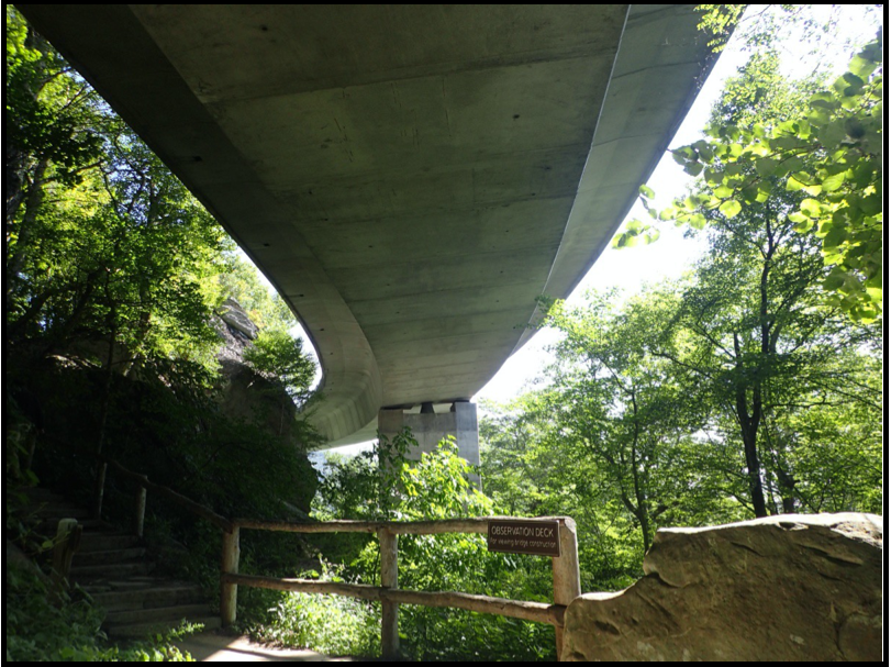
On the last day of our trip we went to the Linn Cove Viaduct on the Blue Ridge Parkway, located at Milepost 304.4. Anyone who traveled the Parkway in the late 1970’s–early 1980’s will likely remember the tortuous detour at Grandfather Mountain. Delay in the construction of this “missing link” was the result of controversy surrounding protection of the unique environment at Grandfather Mountain. The area has an unusually large number of endangered plants and animals. The mountain has been designated an International Biosphere Reserve. The solution was an S-shaped bridge skirting the mountain, which is an engineering marvel. It consists of 153 pre-cast concrete sections which were set by construction cranes from above onto seven piers. It extends for 1,243 feet. Construction of the bridge was complete by 1983 and the missing 7.5 mile segment opened in 1987. A visitor center is available near the bridge, and it is possible to hike on a trail under the viaduct. This provides an unusual view of the bridge structure. It seems that “S Bridges” still have a place in modern times.
After visiting the bridge we returned to the US 23 route through Tennessee and into Virginia. At Duffield we turned west on US 58 to Middlesboro, Kentucky and Cumberland Gap. This 800 foot break in the Cumberland Mountains was the major route to the western territories in this part of the country. For those who have not visited here lately, a tunnel was dug under the gap to separate the highway from the historic crossing. It opened to traffic in 1996. The crossing itself has been restored to its natural state. The reason why there is a gap here at all is due to the site being a meteor crater, called the Middlesboro Impact Structure, which was created by a meteor the size of a football field three hundred million years ago. Middlesboro claims to be the only city in the United Stated to be situated in such a crater. It is possible to go to an overlook which features an impressive view fifty miles in each direction. After Middlesboro we continued on US 25E to I-75 two hundred miles and returned to Cincinnati.
Three weeks after our getting home, the Category One Hurricane Florence made landfall near Wilmington, North Carolina. Wind gusts reached 105 miles per hour and deposited 39.5 inches of rain on the area. Flooding along the Cape Fear River near Elizabethtown, where the Cape Fear Lock and Dam 2 is located, crested at 61 feet. Normal flood stage is 35 feet. Forty eight people were lost. Property damage was between $35-50 billion. It is a very strange feeling reading about damage like this in an area you had just recently visited.
BILIOGRAPHY
1) R. Kapsch, Historic Canals & Waterways of South Carolina, pp. 32, 75 & 100, University of South Carolina Press 2010.
2) D. Patterson, Navigating the Cape Fear: Locks are Key, Coastal Review Online, September 25, 2015.
3) A. Wagner, Want a Dam? Three might be available along the Cape Fear River, Star News Online December 3, 2018.
4) R. Houk, Blue Ridge Parkway Road Guide, Sierra Press 2006.
5) S. Janssen Sr. ed., The World Almanac and Book of Facts 2019, p.38, Simon & Schuster 2018.
6) A. Coleman, North Carolina Transportation Museum, Arcadia Press 2018.
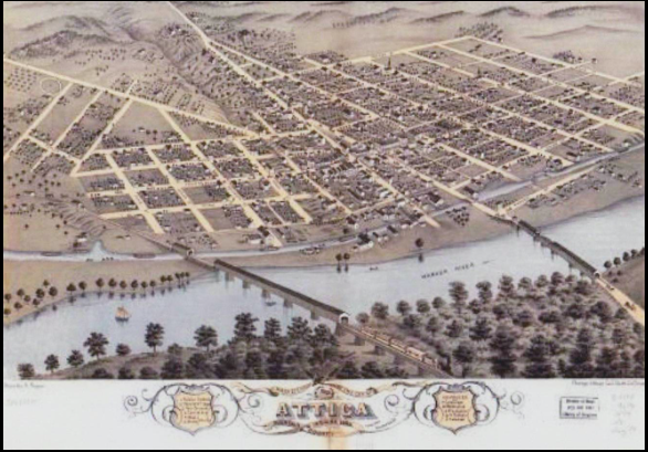
Grain Elevator at Attica, Indiana
Once the Wabash & Erie Canal was built through Indiana, it opened up markets for farmers to sell their products. They began growing more and more wheat and corn. Grain elevators were built beside the canal where farmers could take their crops and then ship them by canal boat.
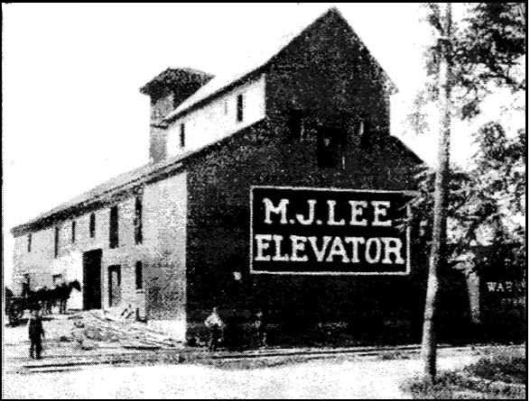
The Grain Dealer Journal, Vol. VII, No. 13 published in Chicago, Illinois on November 25, 1901, published the following report about the Lee Elevator at Attica.
M.J. Lee’s Elevator at Attica, Indiana.
For nearly 100 years, Attica, Ind., has been the site of a grain-shipping warehouse which in its time has handled millions of dollars’ worth of farm products. Its history dates back to the palmy days of the Wabash & Erie Canal, on the banks of which the old Red Elevator was erected in 1848. The founder of the enterprise was Edward Wilson; and his successors were Nave & Todd, who were followed by Armstrong Colvert and the present proprietor, M. J. Lee.
The warehouse was substantially built with heavy timbers, with a view to supporting any weight that could be placed on its three floors. Grain was loaded into canal boats tied up at the door of the large basement. When the canal fell into disuse and shipments had to be made by railroad the grain was loaded into cars with considerable inconvenience.
To improve the loading facilities and utilize the large storage capacity of the old building to the best advantage, the new proprietor has remodeled one end of the structure into a modern elevator, with bins, spouting elevators, corn sheller, car loader, hopper scales and automatic wagon dumps. A receiving sink is provided so this end of the house can be used as a transfer elevator. About 350,000 bushes of grain are shipped annually over the Chicago & Eastern Illinois and Wabash railroads.
With storage capacity for 100,000 bushels of ear corn, Mr. Lee is enabled to receive grain continuously when cars for shipment are scarce. When dealers not so fortunate are compelled to stop for want of cars he keeps right on buying. Also, the waste cobs are kept under cover and dry, and in this condition find a ready sale at 50 cents a load.
M.J. Lee has other interests, an elevator at Kempton and brick and tile works at four other points, to absorb his attention, and has engaged C. J. Britton as manager and T. P. Campbell as accountant for the business at Attica. Reproduced herewith is a view of the elevator from the track side.
Maps and Pictures of Attica
Terry Bodine, CSI director from Covington, Indiana, was given the following birds-eye views and pictures taken of historic photos of the Wabash & Erie Canal by Jeff Bossaer, an historian from Attica. Jeff has reorganized the Fountain County Historical Society.
ATTICA 1869
ATTICA 1869 Close Up
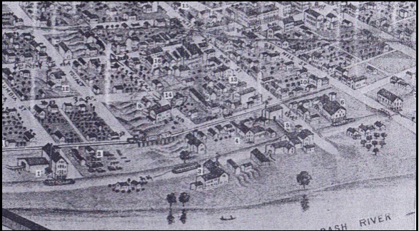
- Nave & Son Elevator, later Stafford Elevator
- Lumber Yard
- Warehouse
- John Schuessler & Bros. Foundrry & Boiler Shop
- James Martin & Co. Grain Warehouse & Lumber Yard
- J.R. Edgerton Warehouse
- The Attica Mills Co. located on the canal below Attica Locks
- C. D. Sylvester Pump Factory
- Hess & Harvey’s Wagon Works
- Smith & Peterson’s Wagon & Plow Works
- Edward Hellwig Pottery Plant
- Yount Woolen Mill
- Fisher, Arbogast & Col. Carriages
- Nixon & Van Deventer Elevator built on this land in 1876
- Shipp’s Wagon & Carriage Shop, later Leaf Buggy Co.
- Revere House, later Attica Inn
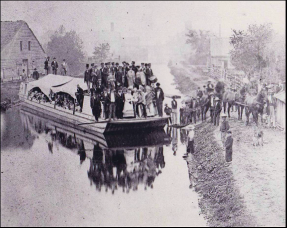
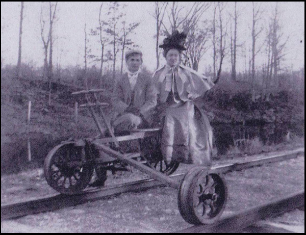
Lou Kopf and Ed Lippold were married May 16, 1872, on a canal boat at the landing at the foot of Mill Street in Attica. The little girl on the barrel in the foreground is Emma Mentzer, mother of Chef Daughtery. On either side of her are her parents. A brass band with drums are on top of the boat. A dog on the right stands before the two horses that pulled the boat. A little boy on the right clutches a man’s leg. There are around 80 people in the picture, some are to the right behind the horses.
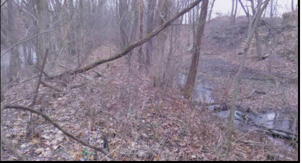
Wabash & Erie Canal Towpath in Fountain County
This 2018 photo was taken in Shawnee Township, Fountain County, Indiana, of the remnants of the Wabash and Erie Canal near “New Bridge” over the Wabash River. From 1881 to 1932 The Wabash Railroad branch to Covington was atop this old towpath.
The Attica Bridge Company built “New Bridge” in 1905. They transported all the building materials, workers and equipment to the site on the railroad.
The canal served several small towns like Fountain (Portland Arch) located a short distance from this site.
The photo displays the Wabash river on the left, the towpath in the center, and the canal prism on the right.
Irish Workers’ Shanties Readied for Rent
Volunteers in Delphi, Indiana’s Canal Park are restoring three old log buildings to represent an Irish Canal Workers Camp. They plan to rent them out to visitors during warm weather for an overnight experience in an 1850s setting.
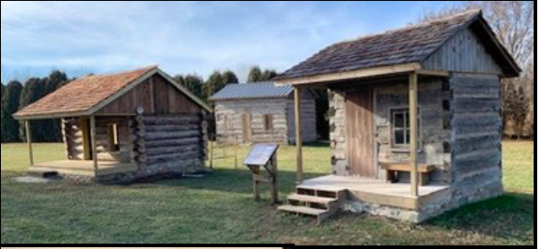
The smallest of these buildings was initially intended to be restored as a playhouse by Denny and Martha Lewis. When this didn’t happen, they donated the building to Canal Park in memory of Neda Coghill Bushman, Martha’s mother, who had been a Director on the Carroll County Wabash & Erie Canal Association’s board.
The medium sized building can accommodate a couple overnight in Canal Park. It was constructed beside Lake Freeman near Oakdale Dam from pilings and an approach for a old bridge at Pittsburg on the Wabash. It had been used for years as a family gathering cabin by the Grantham, Israel and Goyer families, who donated it to Canal Park.
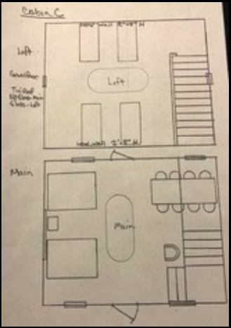
The largest building will provide space for 6-8 persons. It was an early farm structure located on an Ayres farm near Bringhurst, Indiana. It once held farm animals. After its logs were salvaged, they were cleaned, sized, and rotted or damaged logs eliminated thus reducing its original size. The old lumber found at the site was used for the rafters and as shingle underlayment. This building has stairs to a loft with sleeping quarters. The stairs are from a Canal Toll Station near Huntington. The stair treads show wear from thousands of boots.
All of these buildings were set on new stone foundations and roofed with shingles. They were placed adjacent to Canal Park’s RV Park where restrooms and showers are already provided.
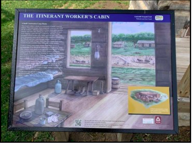
A sign located near the buildings explains that itinerant worker used shanties as living quarters during 1830-40 canal construction. It shows what the shanties might have looked like inside.
The Canal Association is looking for period furniture, fixtures, hook rugs, etc. for inside the shanties. To donate an item contact one of the following:
dan.mccain@gmail.com lrcooper@outlook.com
Arba D. Perry: Canal Contractor & Civil Engineer
By Carolyn Schmidt
Most of the following information is from Commemorative Biographical Record of Prominent and Representative Men of Indianapolis and Vicinity published by J. H. Beers & Co. of Chicago in 1908. Although several family member trees on Ancestry.com had genealogy on Arba D. Perry, they were all mixed up on dates, who was the parent or sibling, etc. and did not match what was in the Beers publication so I, Carolyn Schmidt, am unsure of Arba’s birth date.
Arba D. Perry, was born in Saratoga county, New York near Edinburg to Mr. and Mrs. Benoni Perry. He spent his early life there until the age of thirteen. His mother died and, after her death, his father remarried. Arba’s new stepmother was very unkind to him. Finally, after being whipped by her, he ran away from home never to return.
Arba successfully made his own way. He learned the trade of carpenter, and built up a prosperous business as a contractor and builder whose work was in unusual demand.
Arba was married in Pennsylvania to Christina Hann, the daughter of John Hann, or Newcastle upon Tyne, England, who had come to the United States and located in Chester county, Pennsylvania where he was a coal merchant. John died at Point of Rocks, Maryland.
Christina and Arba had three children who grew to maturity: Thomas P. Perry, of Marion, Indiana, who became a contractor and builder during his active years; John Calvin Perry, who was born February 21, 1834, at Paoli, Chester co,, Pennsylvania; and Anna C. Perry Earp, the widow of B. F. Earp, who later lived with her daughter Annie in Washington, D.C..
In 1836 Arba, Christina and their children moved West by wagon. Their original destination was St. Joseph county, Michigan, where Arba had entered a tract of land. But because of the prevalence of ague in that region they moved through Indianapolis to Harrison, in the western part of Hamilton county, Ohio.
At Harrison Arba built the aqueduct across the Whitewater River to carry the Whitewater Canal across the river. The canal ran down the Whitewater River valley from Hagerstown, through Cambridge City, Connersville, Brookville to Lawrenceburg, Indiana. After finishing the Harrison aqueduct, he built another aqueduct across the Whitewater River 14 miles north of Lawrenceburg, Indiana. It fed water into the Whitewater Canal. Both aqueducts were constructed about 1836.
The Indiana State Archives has a contract dated 8/26/1836 for No. 590 for Section 24EX with A. D. Perry and Milan Littell as contractors. I can’t be sure that this is Arba since it does not fit into the information I have. The Archives also has a contract dated 12/16/1836 for No. 42 for Section 23EX of the Whitewater Canal with Arba D. Perry as contractor.
Unfortunately Christina Perry, Arba’s wife, passed away in September 1837. After her death Arba took the contract for a dam across the White River at Waverly, Indiana, and, when that was completed, took a contract for eighteen miles of the Wabash & Erie Canal along the Maumee River, in Ohio. There he died in 1842 leaving his three children.
According to Beers “Though only a young man, he had reached a high position in his line of business, as may be judged from the character and importance of the work entrusted to him…Possessed of a fine mind, and gifted with unusual mechanical ability, he gave evidence in his remarkable career of the possibilities open to a thoroughly trained tradesman who supplements technical knowledge with the intelligent judgment which enables him to see and fill the needs of his time and place.”
Christina Perry’s relatives reared Arba’s and Christina’s children. According to Beers, “John C. Perry was adopted by her sister Martha, who was the wife of Richard Calvin, of Hamilton county, Ohio. He lived with them until he was sixteen, when he decided to learn a trade and prepare to make his own way in the world.”
John Calvin Perry learned cabinet making, followed that trade to Indianapolis in 1853, and continued in it until the breaking out of the Civil War in 1861. He then engaged in both the retail and wholesale grocery business beginning as a retailer, then a jobber, and finally settling as a wholesale grocer. In 1908 he was the head of the oldest wholesale grocery house doing business in the State, a leader in that line in Indiana and the West.
John C. married Catherine Rebstock, a native of Tuscarawas county, Ohio in 1856. They had four children.
Catherine Rebstock Perry was born in 1837 and passed away in September 1901. John Calvin Perry passed away on May 20, 1921 in Indianapolis, Indiana at the age of 87.
Work Begun on North Feeder Dam Trail
Eight members of Whitewater Canal Trails (WCT) began construction of the second section (Phase 2 -northern section) of the Feeder Dam Trail being constructed from Metamora to Laurel, Indiana on February 29, 2020. It will extend from the end of Phase 1 to the Laurel Feeder Dam, a distance of about another two miles.
Construction on this trail began in 2015 when WCT volunteers started cutting a path along the canal to see what it would take to build the first two mile section. At that time the canal corridor was overgrown with brush and trees. The canal was shallow and nearly full of silt in spots and it wandered back and forth like a little creek instead of looking like a canal. There was a lot of work to do, but after four years of planning, fundraising, dredging and construction, Phase one was completed in 2019.
Letter Relating Problems Caused by Canal Break
Neil Soward, CSI member from Ft. Wayne, Indiana, found a letter on e-Bay showing the problems a break in the Hocking Valley Canal caused businessmen. The letter, dated December 12, 1847 was sent to John T. Brazee, Esquire at Columbus, Ohio from Jacob Greene at Lancaster, Ohio.
Lancaster, Dec. 12th, 1847
John
We were not able to send off any of our flour before the canal filled up on Thursday morning. Capt. Shoup left his boat at the mill and it was nearly loaded when word came of the filling in of the canal. The boat was then unloaded and is gone home. The Brilliant Capt Morgans boat was at Carrol coming in when the bank gave way.
The flour of course must remain but what shall we do with our beans—We hear that the canal is broken in several places near Circleville. Mr. Clark I think is gone to Columbus and will give you all the Boatmen learn. We hear nothing from Capt Hall nor have we last night any letter from Portsmouth—what shall we do with the beans at Portsmouth—will you be so good as to write to Mr. Kauffman and say what you think had but be done with it.
I hope the Legislature will soon be satisfied that something must be done to improve the navigation of the Hocking Valley Canal or it will become of little value to the State or the inhabitants of the valley—There is but little wheat coming in.
Respectfully yours truly, Jacob Greene
Canal Scene on Stamp Cover
Sam Ligget, CSI director from Terre Haute, received the following stamp cover from Earl Toops, CSI member from Fort Wayne who attended the Toledo Stamp Expo ‘20 held February 28, 2020. It was stamped at the Toledo Stamp Expo Station at Perrysburg, Ohio on February 29, 2020. Celebrated on the card was the 175th anniversary of the Miami & Erie Canal (1845-2020) and the Wood County, Ohio Bi-Centennial (1820-2020). A United States flag stamp is pasted in the upper right hand corner.
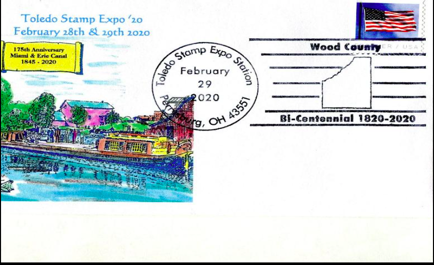
The Miami & Erie Canal provided a 274-mile water route from Lake Erie at Toledo, Ohio to the Great Miami River and then the Ohio River at Cincinnati, Ohio. The portion from Lake Erie to Junction, Ohio was originally built as the Wabash & Indiana Canal. Construction of the $8,062,680. Miami & Erie project began in 1825 and was completed in 1845. It included 19 aqueducts, 3 guard locks, 103 canal locks, multiple feeder canals, and several man-made reservoirs. It was a summit canal with the Loramie Summit being 395 above Lake Erie and 513 feet above the Ohio River. One of its major features was the staircase of 6 cut stone locks at Lockington, north of Piqua, Ohio, which has been visited several times on Canal Society of Indiana tours.
“Farm to Factory” Tour Rescheduled
CSI headquarters received so many calls with concerns and cancellations for its 2020 spring tour ‘Farm to Factory” on April 17-18, 2020 due to the Coronavirus that it was not feasible to hold the tour this year. We are rescheduling for the spring of 2021 and hopefully can set up the same venues for Friday April 16 and Saturday April 17, 2021.
Since we had to cancel the tour, it was decided to refund the fees of the registrants. They will be given priority over others who wish to attend the tour next year.
CSI Life Members
The Canal Society of Indiana encourages members to become life members for $1,000. This money is put into a special mutual fund to ensure the longevity of the organization and is not used for current operating expenses.
Some families are currently contributing toward life membership on the four year installment plan. They are giving $250 per year for four years.
We thank the following for completing their life membership: Carl & Barbara Bauer, Jerry (deceased) & Barbara Lehman, Bob & Carolyn Schmidt and one family who wishes to remain anonymous.
Members Support CSI Signs
Canal Society of Indiana members have showed support of the society’s signage program through recommending where signs be placed, funding signs, and making arrangements for getting them erected. It is a huge success. We greatly appreciate the following who have individually sponsored signs:
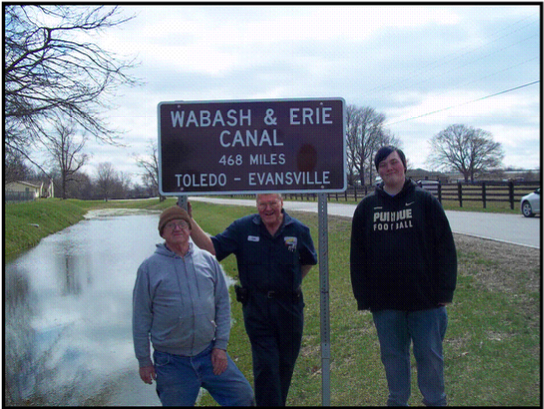
Wabash & Erie Canal: Terry & Ann Bodine, Tom & Linda Castaldi, Phyllis Hess, Sue Jesse, David Kurvach, Bob & Carolyn Schmidt
Whitewater Canal: Webster Hall, Dr. Ron Morris
Be on the look out for the signs. More will be erected this year.
Sign Up, Head All Right
By Sam Ligget with photos by JoAnn Ligget
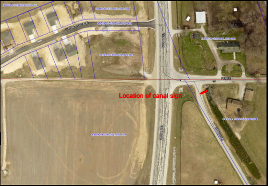
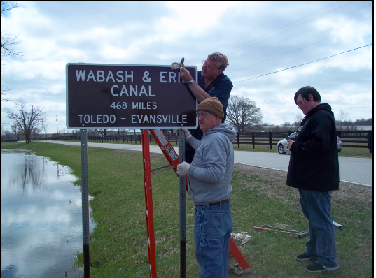
Sam Ligget, CSI director from Terre Haute, Leon Billing, CSI member from Terre Haute, and Eli Elkins, Sam’s grandson, spent St. Patrick’s Day, Tuesday, March 17, 2020 erecting another of the Wabash & Erie Canal signs. It is located on the south side of Terre Haute at the junction of Feree and Davidson Roads and visible from the new Canal Road. The weather was great and the canal was watered making for great pictures.
Sam got permission from the property owners to erect the sign. He then filled out the 811 Homeowner’s Ticket to make sure they wouldn’t hit any utility lines during installation. Meanwhile Leon constructed the posts from an old highway post.
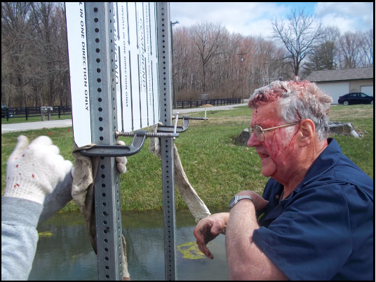
Leon had made a post driver. White erecting a post, he lifted the driver too high. It toppled and hit him in the head. He bled all over the place, but hadn’t realized he was hurt until he saw the blood. Sam, called his wife Jo Ann, who was coming later to take pictures, and told her to bring first aid supplies. She also brought water to clean up his wound. Later that day Sam called to see how Leon was feeling and his wife, Sandy, said he was just fine.

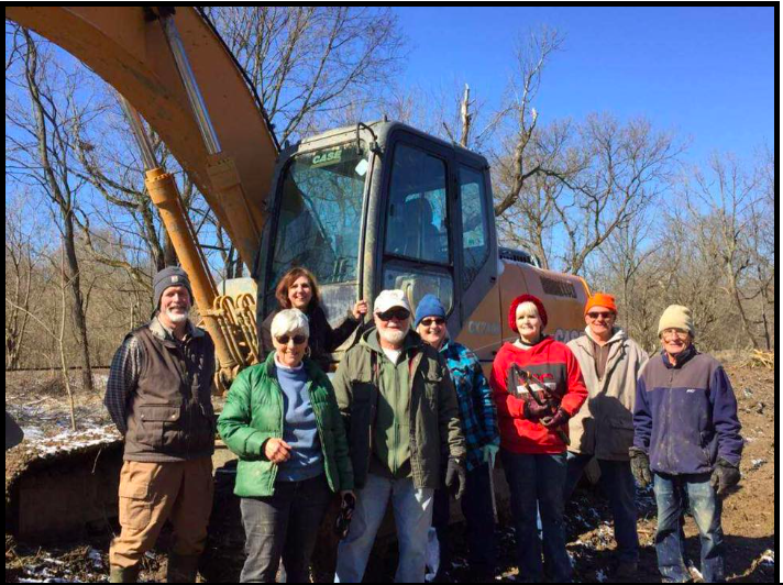
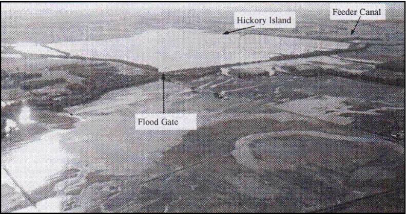
Splunge Creek Reservoir Marked
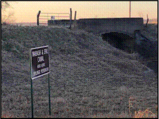 The marker for Splunge Creek Reservoir, which covered 4000 acres in a remote area of Clay County, was erected on March 7, 2020, by Jeff Koehler, Clay County historian and CSI director. He placed it at the control gate for the reservoir. The reservoir lies behind the control gate shown in the picture. It is no longer watered and is used as crop land.
Jeff placed the posts over three feet deep in the ground. He took the pictures late in the afternoon.
Splunge Creek Reservoir, completed in 1849-50, was thought to be a source of ague and fever. In 1849 petitions were signed by those living near it and sent to the canal trustees asking that the trees be removed from it before filling it with water. Dr. Ezra Reed reported that was unnecessary except at the margins around the reservoir.
In 2008 about half of the reservoir was covered with water when the control gate failed during a major flood. Jeff’s cousin photographed the reservoir while Jeff flew the plane over it.