

In this issue of
THE TUMBLE
- Riley Lock 47 Grand Opening
- Tunnel Vision
- Census Records As A Canal Information Source
- Passenger Pigeons on the Wabash and Erie Canal
- Creating Riley Lock 47 Park
- Finding the Source of the Wabash River
- Reimagining a Canal Boat: Blending History and Modern Technology
- Creating And Using Canal Scrip
- Canal Notes #15: Underground Railroad
- Godeke Acquires RR/Canal Map
- Outreach Events & Programs
- From the Whitewater Valley
- Canal Society of Indiana
- News and Programs
Riley Lock 47 Grand Opening
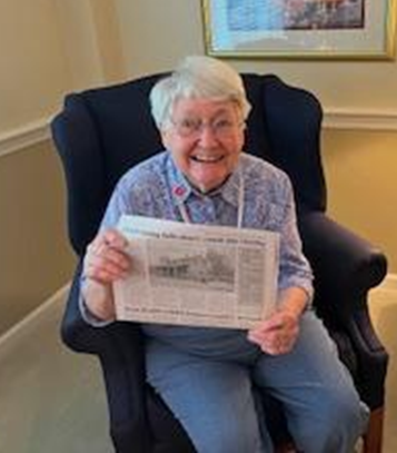
Jo & Sam Ligget (Terre Haute)
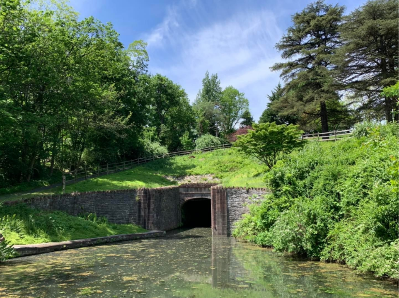
The ribbon cutting for Lock 47 Park at Riley, Indiana, was held at 10:00 a.m. on Saturday, September 6, 2025, a day with beautiful weather! There were 40-50 people present at that time. All were invited to sign the ribbon after the ceremony.
Among the dignitaries were former county commissioners Bill Bryan and Brendan Kearns and present commissioner Mark Clinkenbeard. Adam Grossman, Director of the Vigo County Parks & Recreation Department, cut the ribbon and addressed the crowd. Bobbi McPeak, who was president of the Junior Historical Society of Indiana in 1971 when they purchased the 10 acres containing the lock, came for the ceremony.
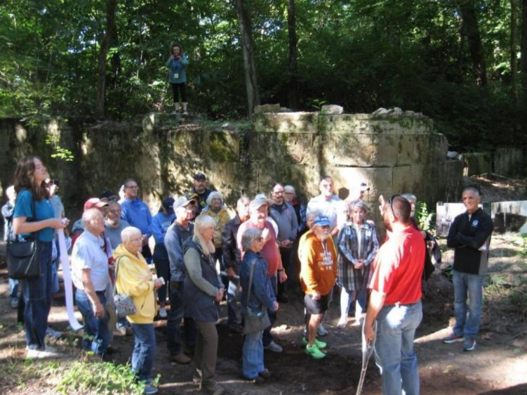
There were 5 Canal Society of Indiana members present including Ron Morris, President, who came from eastern Indiana; also Jeff Koehler, Suzy Quick Dunning, Sam Ligget, and Jo Ligget. Suzy also represented the Vigo County History Center along with its director Marla Flowers.
Jeff, Sam, and Jo arrived before 9 a.m. and stayed until 3:30 p.m. to answer questions from the
public about Lock 47 and the canal in general. Most of the crowd left by noon, but over 30 people came in the afternoon. Some were still stopping by after 3:30. It was interesting to see people of all ages. Three even mentioned they first discovered the lock while mushroom hunting.
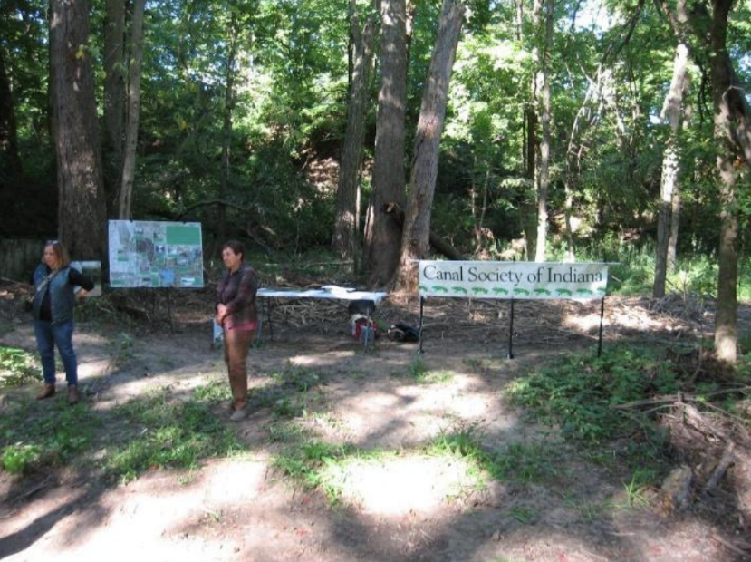
The Liggets set up the Canal Society of Indiana banner and a table where there were handouts supplied by the society showing a map of canals in Indiana and giving an explanation of lock operation as well as some canal artifacts brought from the museum by Suzy Dunning. Jeff Koehler displayed a large map made by him and his son showing the canal route through the area. The Liggets had 3 yard signs made: 2 with pictures taken long ago at the lock and the other of culverts. One picture was Civil War veteran Isaac Lowe standing on Lock 47 while the other was his son Warren Lowe, Riley High School teacher, sitting with his class on the lock wall.
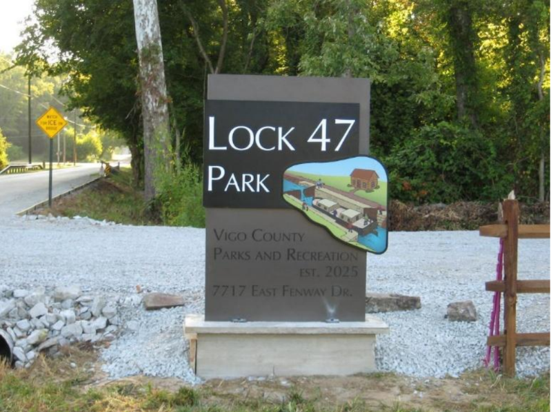
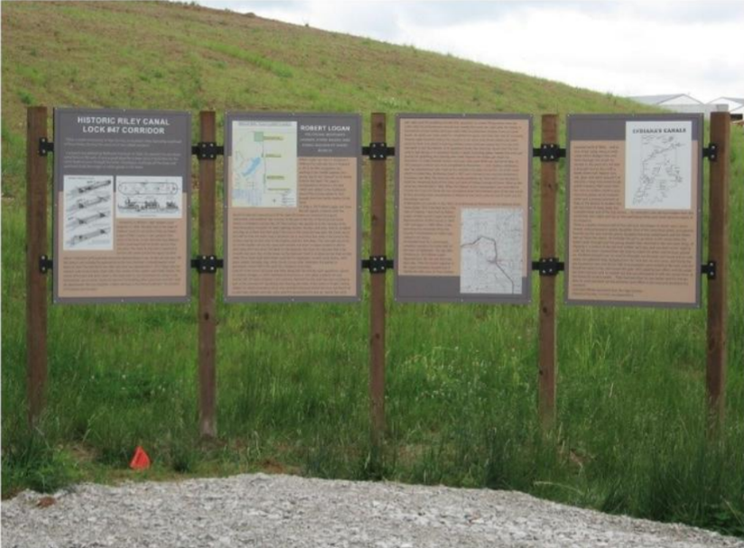
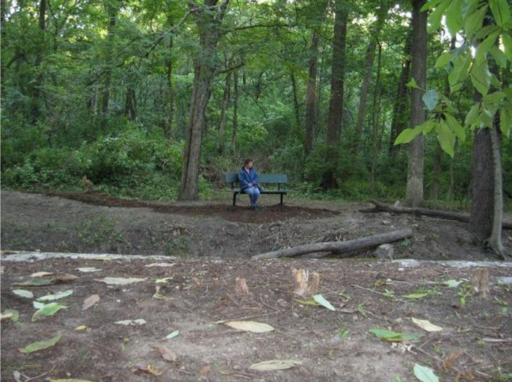
The Parks Department put up a Lock 47 Park sign with its newly designed logo at the parking lot. There is also a large 4-panel sign there telling the history of Lock 47 and explaining how locks work. The path to the lock is on the towpath with a sign informing visitors of that. Above the lock, there is a nice bench where one can sit and imagine the boats locking through many years ago.
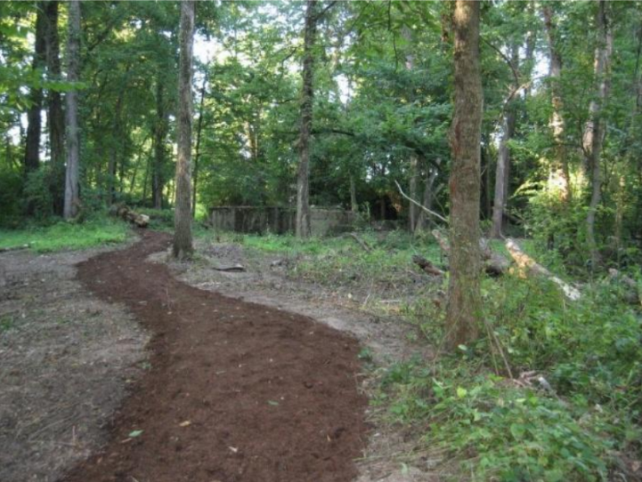
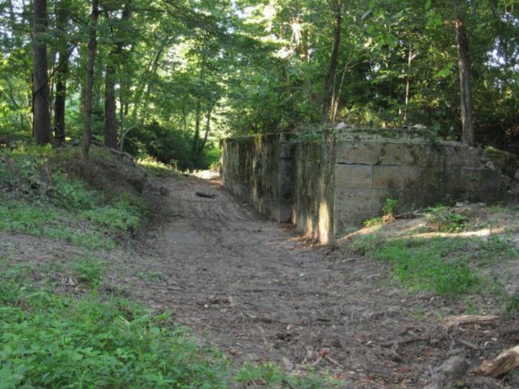
If you find yourself in the Terre Haute area and have some spare time, you might want to take Highway 46 to Riley, Indiana. Just east of the brown CSI canal sign, (left )take Frye Road north to Fenway and turn west (left). After a short distance, you will come to the Lock 47 Park sign and a small parking lot. The trail to the lock is fairly short, and you will get to see the remains of what Chief Engineer William Ball called the finest lock on the Wabash & Erie Canal.
Tunnel Vision
Carolyn Schmidt
Building a canal was no simple feat. Engineers had many obstacles they had to overcome. One of these obstacles was a high ridge. They had to decide whether to go around the ridge, use locks to go up and over it if they could find a water source, or build a tunnel to go through it. The history of three canal tunnels in the United States will be given in this article, two of which are still accessible today.
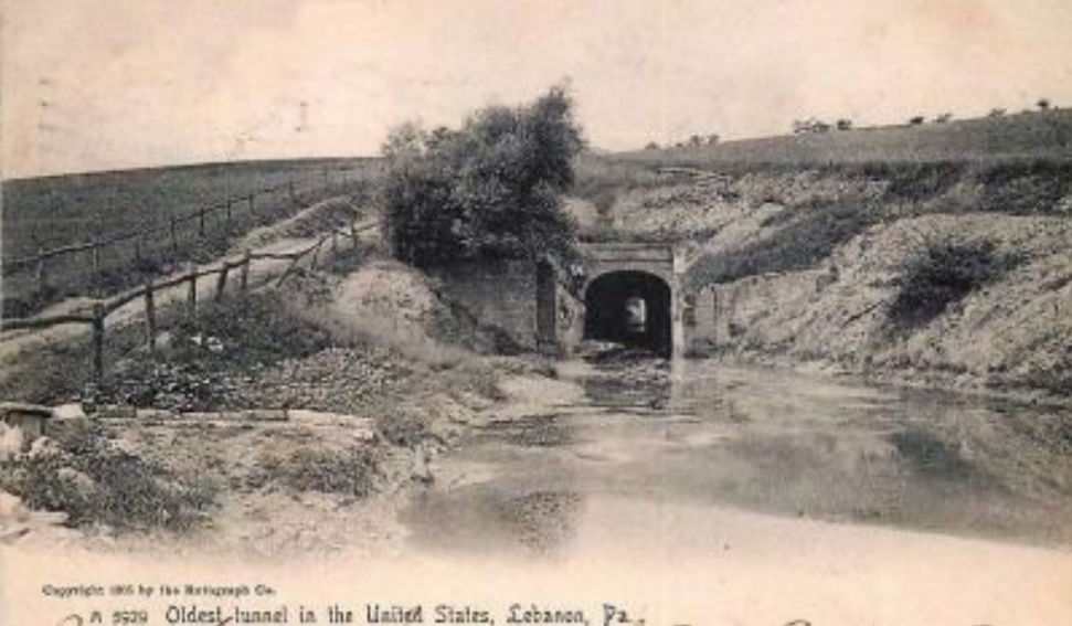
Union Canal Tunnel
Oldest Existing Transportation Tunnel in the U. S.
A tunnel was needed to pass through a small ridge that separated Quittapahilla Creek and Clarks Run in Pennsylvania in order to link the commercial centers of Harrisburg and Reading, and later extending it to the port of Philadelphia. Construction of the 729-foot-long tunnel began in 1825. Considering that the work was done entirely using hand tools and black powder, it progressed at about 15 feet per week and amazingly was completed in two years by 1827.
Although this canal was a vital link for 58 years, the competition from many railroads in Pennsylvania caused it to be closed in 1885. The tunnel was abandoned and fell into disrepair.
The Civil Works Administration, along with the Lebanon County Historical Society, began to stabilize and restore the tunnel in the 1930s. In the 1950s the society purchased the tunnel to further preserve the site, which was recognized as a National Historic Site in 1970. In the late 1900s just over a half mile of the canal was dredged, the tunnel restored to its mid-19th century appearance allowing small boats to pass through it, and a 110-acre Union Canal Park was created. The park preserved the tunnel and the only remaining 5/8-mile section of the original canal through Lebanon.
A visitor reports starting a hike from the main parking area and following a 0.7-mile loop trail along the Tow Path and the Sunny Side Trail in the southern portion of the park. He said the trail was flat. It followed the old towpath towards the tunnel and allowed the visitor to easily see 1,700 feet of the restored canal. Right before the tunnel there was a wide turning area where mules were unhooked from the boats when the canal was operating. The mules then walked up and over the ridge while the boat was pushed with poles through the 729-foot-long tunnel. The mules were hooked again to the boat on the other side. He said the stone face of the tunnel that was visible from the turning area was in “impeccable shape.”
The main entrance to Union Canal Park is located at 25th St. and Union Canal Drive in Lebanon, Pennsylvania. Pictures below show the tunnel as it appeared years ago and how it appears today.
Paw Paw Tunnel
Longest Canal Tunnel in the U. S.
When canal engineers were planning the Chesapeake and Ohio Canal (C & O) in Allegany County, Maryland, they encountered a six-mile stretch of the Potomac River containing five horse-shoe-shaped bends. To save building six miles of canal they decided to build a 3,118-foot-long tunnel through a steep ridge now known as Tunnel Hill, bypass the river bends, and thus shorten the route of the canal. They estimated the project could be completed within two years and cost $33,500. But this was not the case.
In 1836 work began on the Paw Paw Tunnel, which was named for the pawpaw trees that grew on the nearby ridges. There were labor issues and violence among immigrant laborers of different ethnicities, funding shortfalls, unpaid workers, work stoppages, and the extreme challenge of building such a long tunnel through the hard and loose shale. It finally was completed 14 years later at a cost of $600,000. Even after the tunnel was opened in October 1850, rockslides continued to be a challenge throughout its history.
The Chesapeake and Ohio Canal Company was nearly bankrupted by the high cost and delay in completing the tunnel. The canal itself was not completed as planned. Although it originally was to go to Pittsburgh, Pennsylvania, it was stopped short at Cumberland, Maryland.
The Chesapeake and Ohio Canal closed in 1924 and the tunnel, which had been used by canal boats, sat idle. Today, the tunnel remains one of the greatest engineering feats of its day. It and the canal towpath are part of the Chesapeake & Ohio Canal National Historical Park and are maintained for public use. The park’s address is Tunnel Hill Rd., Oldtown, Maryland 21555. To reach the park leave the town of Paw Paw, cross the Potomac River on 9, which becomes 51 as you head toward Cumberland. A few miles west of Berkeley Spring, W VA. and, just after a sign for the tunnel, there is a small road next to a bridge that takes you to the tunnel parking lot.
Walk one half mile to the tunnel following the trail signs. Be prepared with a flashlight or head lamps to walk into the tunnel. Although the path in the tunnel is fairly rough, railings keep hikers from falling into the canal. You will see weep holes, rope burns, rub rails, and the brass plaques that mark every 100-feet of the tunnel and bring its history alive. For breath taking views of the canal walk the two-mile long Tunnel Hill Trail.
The portal of the Paw Paw Tunnel is seen below.

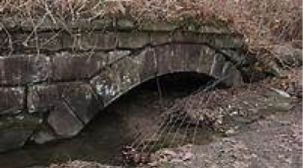
Cleves Tunnel
Closet Abandoned Canal & Railroad Tunnel to Indiana
Ohio had cooperated with Indiana by allowing Indiana to build seven miles of her Whitewater Canal around high ridges in Ohio before returning her canal to Indiana. As part of the agreement between the two states, the State of Ohio required that Indiana allow future access to her canal at West Harrison, Indiana. Ohio could easily join an extension canal at this point at a later date. The Canal Society of Indiana placed an Indiana State Format Marker near this junction in 1999.
Ohio businessmen saw this an as opportunity to build this extension on their own, funnel some of the canal traffic into Cincinnati and make money while Ohio was busy building her other canals. They formed a private company.
In 1836, Indiana had begun building the Whitewater Canal that was to eventually extend from Cambridge City, Indiana to Lawrenceburg, Indiana. In 1837, construction began on the Cleves Tunnel, which cuts through a ridge between Cleves and North Bend, Ohio near Cincinnati, as part of an extension of Indiana’s Whitewater Canal System.
The canal company’s surveys showed that they needed to construct a 1,782 foot tunnel between Cleves and North Bend. This tunnel was completed in six years and allowed the Cincinnati and Whitewater Canal to open for business in 1843.
The tunnel was built on land owned by retired war hero William Henry Harrison, one of the canal’s early proponents. He happily sold his land for the canal’s right-of-way and supplied wood and bricks for the tunnel. After his sudden death from pneumonia and his one month service as the 9th President of the United States, he was buried on the ridgeline near the tunnel’s southern portal.
The tunnel has ashlar stonework portals with wing walls and is lined with brick that was fired on Harrison’s land. It was 22 feet high between its ceiling and the bottom of the canal. Most canal tunnels had room for a towpath, but canal boats had to pass through the Cleves Tunnel by poling and/or canal men lying on their backs and legging the boat (pushing their feet against its ceiling). The canal water current was from the west (Indiana) to east. The horses or mules walked over the ridge to the other portal and were re-hitched.
The Cincinnati and Whitewater Canal was finally completed in 1843. The Whitewater Canal was abandoned in 1856 due to numerous floods that destroyed much of its length. This led to the abandonment of the tunnel until 1863 when a railroad company began a twenty-five year period of using it as an ordinary rail tunnel. After the railroad abandoned it in 1888, the tunnel began silting up almost to its ceiling making it unusable even as a trail.
The Cleves Tunnel collapsed twice during construction and six workmen were killed. Long after it was abandoned in the 1950s, the east portal was sealed-up during a project to improve the portion of U. S. Route 50 that passes by the tunnel.
In 2000 the Ohio Historical Society, The Canal Society of Ohio, and a group of private organizations placed a historical marker by the tunnel’s northern portal and made a pathway to the site. Its dedication ceremony was on August 5, 2000. The two-sided marker talks about the Cincinnati and Whitewater Canal and William Henry Harrison on one side. The other side is about the Cleves Tunnel and says:
In 1837 Cincinnati merchants projected a branch canal to join the Whitewater Canal at West Harrison, Indiana with the goal of tapping commerce from Indiana’s Whitewater valley. The major obstacles on this route was the ridge between North Bend and Cleves, just northeast of this site. Engineer Darius Lapham designed a 1,782 foot tunnel through this barrier. Lined with brick on site.
At the time the marker was placed the southeastern portal remained sealed off. The tunnel was listed on the National Register of Historic Places in mid-2001. Today the pathway to the tunnel is almost obliterated. The northwestern portal is partially visible as seen below.
Census Records As A Canal Information Source
Stan Schmitt
This article was originally published in the Winter 1984-85 issue of Indiana Waterways. Its valuable information is as pertinent now as it was then in helping researchers.
Have you ever wondered about the people who worked on the Wabash & Erie Canal? Who were the
captains, officials, boat builders and laborers, and where they came from?
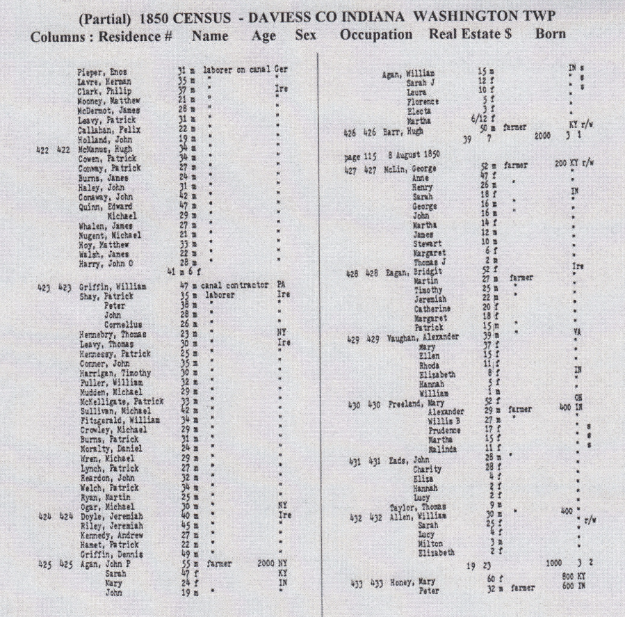
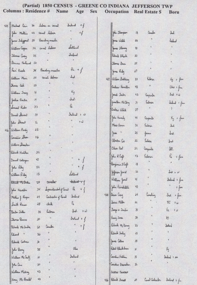
While doing canal and genealogical research at Evansville’s Willard Library I began to notice that census records provided answers to these and other canal related questions. During the lifetime of the Wabash & Erie Canal, Federal censuses were taken in 1840, 1850, 1860, and 1870. In the case of the 1840 census, little definite information relating to the canal can be obtained. The census of that year contained only the head of the household’s name, along with a grouping of the other residents by age and sex. But despite this limited information, there are still a few things which turn up.
At the same time the 1840 census was being taken, work on the Wabash and Erie Canal was progressing through Carroll County with Reed Case as one of the contractors. This may explain why the Carroll County census of that year shows Reed Case as the head of a 117 member household. There are similar entries in the canal counties of Vanderburgh and Vigo for households containing 40 or more members. It is likely that these “family members” consisted of canal workers and their families.
With the 1850 census, more specific canal information begins to appear. In that year census takers began to list the name, age, occupation, worth and place of birth of everyone questioned. With this additional information it is possible to find out who the Wabash & Erie people were. At the time of the 1850 census, work on the canal was being carried out in Greene, Daviess and Pike Counties. In this instance census records factually prove the long-standing story of Irish predominance in canal construction work. Timothy Donovan, a contractor on the canal, is listed in the Pike County census as the head of a household containing a clerk and 94 canallers, blacksmiths and stonemasons. These 94 men, all but three born in Ireland, probably lived in a hastily erected camp and worked on Donovan’s contract to remove rock at the Patoka summit. There are a number of such groups of Irish laborers listed with a contractor, boss or boarding master as the head of the “household.”
These were the laborers, who did the heavy canal work and lived in the temporary shanty towns along its path. These were also the ones who died in large numbers when the cholera epidemics ravaged these unsanitary camps in 1850 and 1851.
Census records also show another lesser-known type of canal laborer, the one with a wife and family. These usually lived alone or with a few other families. Although the heads of the households were usually from Ireland, their wives were, for the most part, from Indiana. In the families where the wives were born elsewhere, another interesting item comes to light. Most children over the age of 15 were born in New York or Ohio, while those under 15 were born in Indiana. With this information we can trace the apparent movement of laborers’ families along the west-ward-moving route of canal construction.
In the counties north of Terre Haute, the 1850 census lists persons with occupations associated with an operating canal. With this information and that of the 1860 and 1870 censuses, it is possible to make these early canal people come alive.
In addition to giving the names of the Wabash & Erie canallers the census records show that a large percentage of them were non-Hoosiers who came to Indiana seeking work. This is especially true in the areas of boat construction, captains and canal officials. Hoosier representation on the canal occurred more in the areas of boatmen, lock tenders and businessmen, where no previous canal experience was needed. By using the information contained in local deed records, tax records, plat books and city directories it is possible to further enhance the information obtained from the census.
How does one go about checking the census records for their own area? Most libraries now have microfilm census records for at least the local county, and many larger ones have the records from a larger area. If you live in the canal counties between Terre Haute and Fort Wayne, the 1850, 1860 and 18870 censuses will be of use to you. In the canal counties below Terre Haute only the 1850 and 1860 ones will be of use.
To check the census records for your county, you must first determine which townships the canal passed through. In doing this, you must remember that some present-day townships did not exist during the canal era. In most counties major towns are listed separately from their townships. Once the correct township is found on the census, it is easiest to look down the “occupation” column for those jobs which are canal-related. By doing this for a number of pages it is possible to determine who some of the canal workers were in your county.
It is possible that some of the known canallers will not turn up on the census returns. This is especially true of captains and boatmen, who often closed up their homes and lived aboard the boats during the shipping season.
While census records won’t tell you everything you wanted to know about the Wabash & Erie Canal, they provide an additional source of information that is worth looking into, especially for those interested in social history.
Although the information used in this article was based on the Indiana Wabash & Erie Canal counties, the method will work for any area of canal construction where census records survive.
Below are samples of the 1850 Census in Daviess county and Greene county, Indiana.
At the time the census was taken canal construction was underway in Daviess, Greene, Pike and other counties in southern Indiana. There are 20 pages of these census records for the 1850s plus 1⁄2 page of the 1850s census in Vigo/Clay counties and 1⁄2 page of the 1860s census in Vanderburgh county, which can be found in “The Final Link” tour guide for the Wabash & Erie Canal in Gibson, Pike, Daviess and Greene counties on the CSI website indcanal.org.
By the 1860 Census canal construction was complete with the exception of repair activities. Today you can go on-line to our website rather than having to go to the library. Most of these workers were individual men who have no other records.
If you need to research an individual name you can try Ancestry.com or Find-A-Grave at your local library.
We suggest you do a wide search by last name first and then refine your search by first name, middle initial, date of birth, marriage or death. You might find that your ancestors remained in the area after the canal was completed. If they became prominent in the area you might find short biographies about them in county histories or old atlases. Some old newspapers carried information about marriages and deaths. Good luck!
Passenger Pigeons on the Wabash and Erie Canal
Margaret Griffin

The passenger pigeon has been officially extinct for 111 years. In 1914, “Martha,” the last one in captivity, died quietly in the Cincinnati Zoo. The population of the Ectopestes Migratorius, commonly called the wild pigeon, had been dwindling for many years. As early as 1876, teenaged Theodore Roosevelt noted in his bird journal that “now and then one is seen.” That was after he’d shot and stuffed a specimen to go with his own collection.
But fifty years earlier, especially in the Midwest, passenger pigeons flew in overpowering numbers, some say which was two billion. How did it happen? With that many, surely the harvest of wild pigeons for their meat wouldn’t make a dent. As it turns out, it did.
Frank Bash, a writer for the Huntington Herald, whose hometown was a main stop on the Wabash and Erie Canal, interviewed senior citizens in the 1920s. Many told memories of what they remembered of seeing and participating in the operation of the canal.
Some articles revealed more about how passenger pigeons were hunted and sent to market on line boats.
In Fall and Spring the gigantic flocks returned to their “permanent nesting” places. The pigeons would scatter from their roosts early in the morning and come back in the evening. Stopovers could last several weeks. One such place was on some bluffs three miles north of Roanoke in Huntington County (Today this is the intersection of US Highway 24 and US Highway 114). A farmer named Paul Salts used to tell that the pigeons disturbed his sleep as they fluttered to beech, poplar, ash, sassafras, wild cherry and maple branches. The branches would easily snap and break under the weight of the birds. The scrub oak tree, however, could hold its inhabitants.
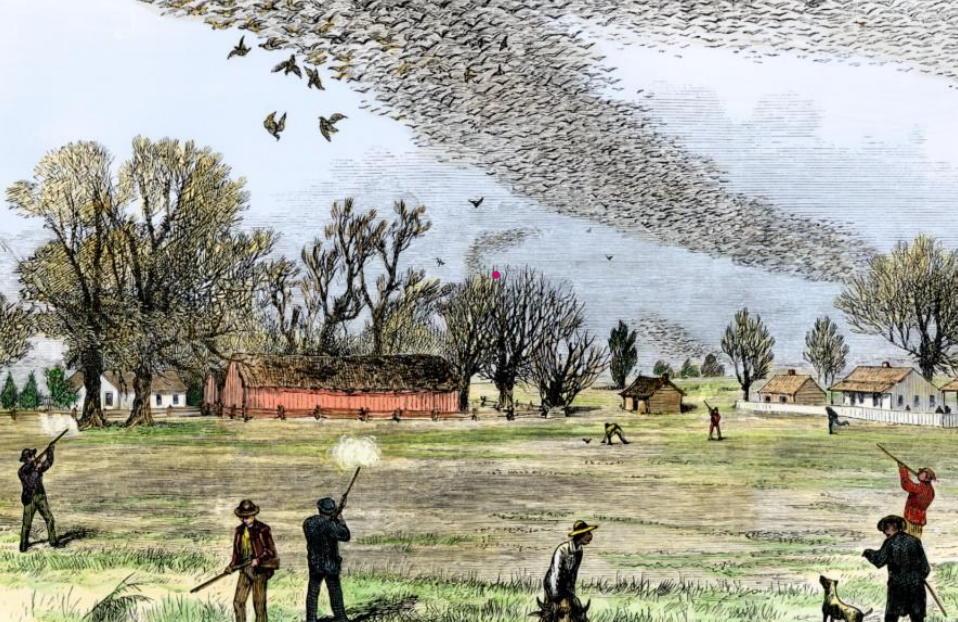
Flocks could be a mile wide, block out the sun and sound like a storm brewing. The surrounding hills looked snow-covered with all the dung.
Killing wild pigeons for the market was not a sportsman’s activity. Men used nets, clubs and guns often while the birds were sleeping. If the birds were in the air, someone sewed the eyes of a pigeon shut and let it go. It would flutter up in the air, become confused, and others would circle around it to the place where grain had been scattered in nets. Thus became the term “stool pigeon.”
Mrs. Mary Schoch told author Bash that her husband and brother-in-law operated a wholesale poultry business in the early 1800s, buying chickens all over the area and cutting them up for sale. He crocheted his own nets, out of which wild pigeons stuck their heads and had them promptly crushed by pinchers. The family always kept a barrel of the smoked pigeon breasts for themselves, which Mrs. Schoch termed “fine eating.” After the flocks thinned out, the brothers went further away to kill and market the birds.
After smoking the meat and packing it in barrels, the take was loaded onto freight boats and sent on the canal, and later the railroad, to other markets. By 1843, when the Wabash and Erie Canal stretched to Toledo, the delicacies could cross Lake Erie and go on the Erie Canal to New York restaurants.
A primary reason for wild pigeons becoming extinct was overharvesting. They were simply slaughtered to make a buck. You see, these birds only lay one or two eggs a year, and could not reproduce as fast as they were killed. Their roosting habitats also disappeared, as people settled and cut down more trees. The pigeons traveled in groups, which became smaller and smaller, then non-existant.
Some would say the Wabash & Erie Canal is extinct, because it disappeared, never to be seen again. But there are sections where you can ride an old-fashioned packet at Delphi, Indiana and Toledo, Ohio. There are signs marking locks and other features all along the 468- mile route. The Canal Society of Indiana keeps it alive through in-person seminars, tours, newsletters, books, articles, and, particularly, this website.
Passenger pigeons were not so lucky.
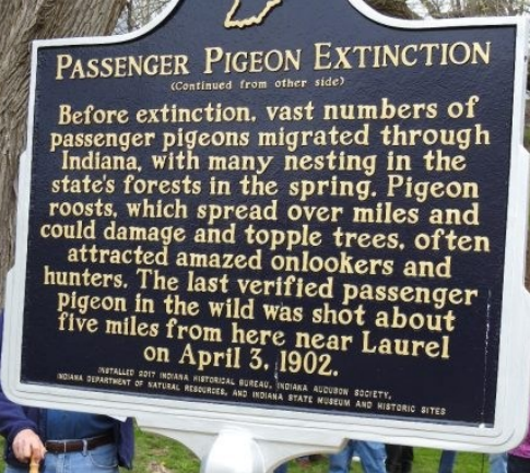
Eight years ago the Canal Society of Indiana contributed $100 toward the erection of a “Passenger Pigeon Extinction” marker that was dedicated on Monday, April 3, 2017 at 1 p.m. in Gazebo Park at the Whitewater Canal State Historic Site, 19083 Clayborn St., in Metamora, Indiana. April 3rd marked the 115th anniversary since a male pigeon was shot near Laurel, Franklin County. This is the last verified Passenger Pigeon to have been collected from the wild.
With the feeder dam for the Whitewater Canal being on the Whitewater River at Laurel, it is likely these waters attracted the pigeons.
Although the speeches given at the dedication first referred to the “taking” of the bird, the fact remains that it was shot, and the text of the marker says that. This happened exactly 115 years on April 3, 1902 before the marker was placed. The corpse was shown to Amos Butler, of Indiana Audubon Society, and therefore confirmed. Later it was stored in a leaky attic, resulting in its loss to science.

In 2013 CSI member Cynthia Powers had an idea for a sign “Lost Birds of Canal Days” to be placed beside “Towpath Trail” along Eagle Marsh in Fort Wayne, Indiana. The CSI board granted Little River Wetlands $1,000 to design and put up the sign that was researched by Cynthia and designed by John Dorrill, a graphic designer. The birds included the Passenger Pigeon, the Greater Prairie-Chicken, and the Carolina Parakeet. Note the canal boat being pulled down the canal in the background, the descriptions of the birds and their habits, and the maps showing where they lived. This sign is in good condition after 12 years out in the elements.
Creating Riley Lock 47 Park
Jo Ligget (Terre Haute)
Lock Visitors
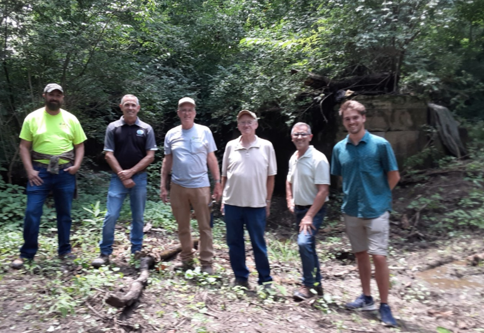
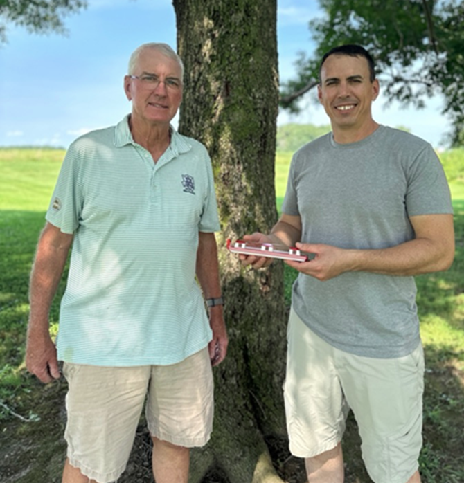
On July 17, 2025, seven people met at Lock 47 in Riley, Indiana to discuss the possibility of getting it, or perhaps even the canal corridor in the area, listed on the National Register of Historic Places. Jeff Koehler arranged the meeting with Kurt W. Garner, Preservation Consultant, who works on such projects throughout Indiana. Kurt and his assistant Daniel Stauffer were impressed with the lock and surrounding park being developed.
Along with the message Jo attached the following photo of the group with Lock 47 in the background. From left to right are Adam Grossman, Vigo County Park Director; Mark Clinkenbeard, Vigo County Commissioner; Jeff Koehler, CSI Board Member and Clay County Historian; Sam Ligget, CSI Vice-President & Board Member; Kurt W. Garner, Preservation Consultant; and Daniel Stauffer, Preservation Assistant.
Tribune Star Announcement
To advertise the grand opening of Lock 47, the Terre Haute Tribune Star carried an article entitled ”Wabash & Erie Canal Lock 47 park grand opening is this weekend,” on August 28, 2025. The problem was that the event wasn’t until the following weekend. We hoped this would not cause confusion and result in a small crowd.
In the article, Sam Ligget, CSI Vice-president, explained how the once planned park only became a reality due to the county commissioners. He said,” The Terre Haute North Junior Historical Society bought the property around Lock 47 and gave it to the Parks Department because they wanted to build a park out of it, but the superintendent at the time wasn’t interested. The department received a $900,000 grant from the state in 2009 to create a park but returned the money in 2013 due to its inactivity.
Adman Grossman said, “ restoring the lock and creating the park cost $7,000 and include a lot of volunteer work.”
“It’s getting way closer to becoming a park,” Sam Ligget said. “Adam Grossman has done a better job with that than what the plans proposed – if you build the parking lot where they wanted it, that land is swampy. So Adam put the parking lot near the towpath because its high grounds.” The parking lot is off Fenway Drive.
Also included in this article was a brief summary of the Lock 47 builder, Robert Logan, who built the lock in 1837-38. Logan created the lock from limestone quarried in Putnamville and hauled to Vigo county.
“William Ball, a resident canal engineer said that this was the best lock in the whole system in Indiana,” said Jo Ligget, Sam’s wife and CSI’s Financial Secretary.
Finding the Source of the Wabash River
Troy Jones
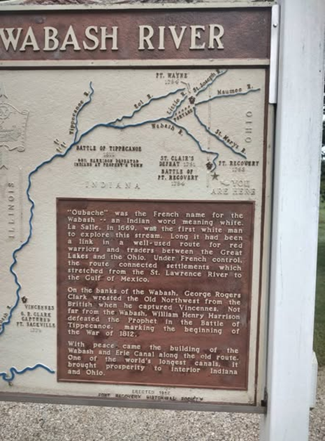
On August 16, 2025 CSI members Troy Jones and his traveling friend John Muciarelli, drove from Clinton, Indiana to find the source of the Wabash River in Ohio. They found the markers shown here and took pictures. The Wabash & Erie Canal is included in the information on the sign since it closely followed the river from below Huntington, Indiana to Terre Haute, Indiana. The canal passed through 380 miles in Indiana and 88 miles in Ohio for a total of 468 miles.
Qubache” was the French name for the Wabash – an Indian word meaning white. La Salle, in 1669, was the first white man to explore this stream. Long it had been a link in a well-used route for red warriors and traders between the Great Lakes and the Ohio. Under French control, the route connected settlements which stretched from the St. Lawrence River to the Gulf of Mexico.
On the banks of the Wabash, George Rogers Clark wrested the Old Northwest from the British when he captured Vincennes. Not far from the Wabash, William Henry Harrison defeated the Prophet in the Battle of Tippecanoe, marking the beginning of the War of 1812.
With peace came the building of the Wabash and Erie Canal along the old route. One of the world’s longest canals. It brought prosperity to interior Indiana and Ohio.
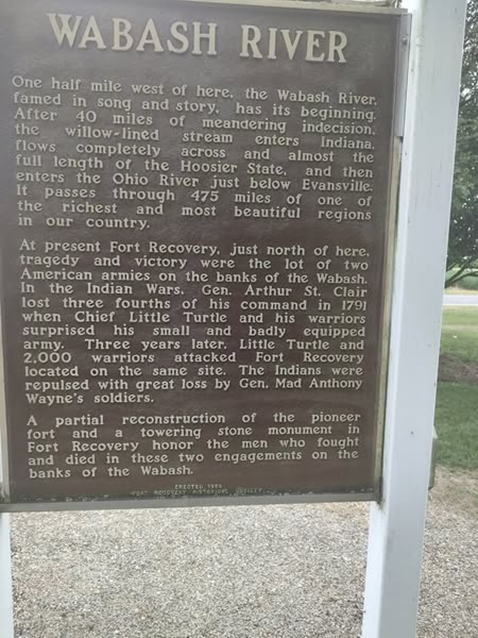
Wabash River
One half mile west of here, the Wabash River, famed in song and story, has its beginning. After 40 miles of meandering indecision, the willow lined stream enters Indiana, flows completely across and almost the full length of the Hoosier state, and then enters the Ohio River just below Evansville. It passes through 475 miles of one of the richest and most beautiful regions in our country.
At present, Fort Recovery, just north of here, tragedy and victory were the lot of two American armies on the banks of the Wabash. In the Indian Wars, Gen. Arthur St. Clair lost three fourths of his command in 1791 when Chief Little Turtle and his warriors surprised his small and badly equipped army. Three years later, Little Turtle and 2,000 warriors attacked Fort Recovery located on the same site. The Indians were repulsed with great loss by Gen. Mad Anthony Wayne’s soldiers.
A partial reconstruction of the pioneer fort and a towering stone monument in Fort Recovery honor the men who fought and died in these two engagements on the banks of the Wabash.
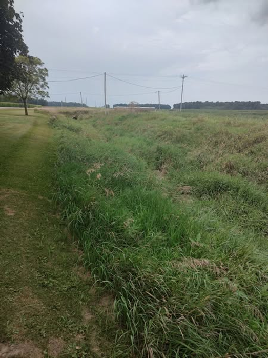
Troy and John found this ditch running under a road culvert alongside a grassy field and lots of power lines. This is how a source of one river, the Wabash, presently looks.
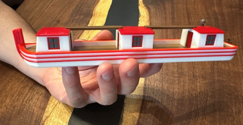
Reimagining a Canal Boat: Blending History and Modern Technology
Cleve Koehler
The Wabash & Erie Canal once stretched across Indiana serving as a vital transportation link during the 19th century. Today, little remains of the canal itself, but its history still fascinates many people. For me, that fascination has a deeply personal connection. My father, Jeff Koehler, is an avid historian who has spent decades studying the Wabash & Erie Canal. He has explored the remaining traces of the canal, and given countless presentations and tours to share what he has learned. His dedication inspired me to think about how I could contribute to his work.
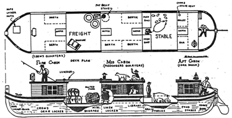
As an engineer, I work with tools and technologies that can turn ideas into tangible objects. One of my skills is using 3D design software, and I realized that I could help my father’s storytelling by creating scaled models of historic canal boats. These models could give audiences a visual connection to the boats that once traveled the canal, helping them better understand the history he shares.
To create the model, I used historic records describing the general dimensions of the typical boats that operated on the Wabash & Erie Canal. These boats were long and narrow, designed to fit within the canal’s locks and to carry freight efficiently. While no original boats survive, records describe their size, proportions, and some key features.
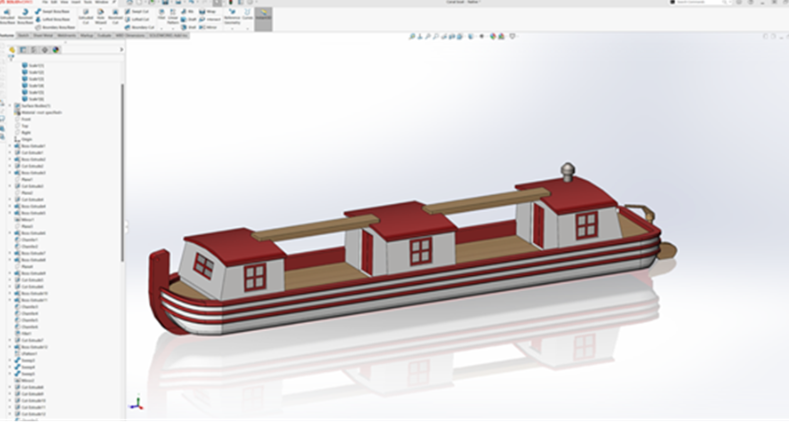
Using this information, I designed the exterior of the boat in a 3D modeling program called SolidWorks, which engineers often use to design mechanical parts and machines. It allows the designer to build a 3D shape on the screen, similar to sculpting a digital model. I kept the process simple for the purpose of this project, focusing on the boat’s overall shape and visible details rather than attempting to recreate every small component.

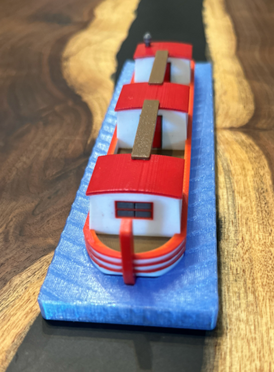
Once the design was complete, I prepared the file for 3D printing. The printer I used is a Bambu Labs X1 Carbon, which can produce objects in multiple colors in a single print. Think of it like a tiny robotic glue gun that draws one layer at a time until a full object appears. 3D printing is becoming more affordable and accessible, and while it’s often used in engineering or art, it has huge potential for historical education. Users can create models of artifacts that no longer exist, like canal boats, in a way that’s engaging, accurate, and easy to share.

Creating And Using Canal Scrip
Carolyn Schmidt
Paying for canal projects was always a challenge. We were lucky in Indiana to have land grants from the United States government that we could sell to defray the cost of building the Wabash & Erie Canal, but as time went on, even more money was needed. Other states had the same problem of funding their canals. Stock certificates were sold, but their purchasers often did not pay all the amount that was needed and the stocks were auctioned off if a buyer could be found. In Indiana, our first lottery tickets were sold to finance the canal at the Falls of the Ohio. This was also done by other states. Even with the land grants, stock sales, lottery ticket sales and tolls for using the canals, there was not enough money to pay the creditors or workers.
Probably the first company to issue canal scrip was the Lehigh Navigation Company and the Lehigh Coal Company in 1818. These two companies combined in 1820 as the Lehigh Coal & Navigation Company. Their earliest notes date 181_ or 182_ with the seller writing in the last digit. By 1826 all the digits were printed. In the 1840s it issued another type of note that was payable after 5 years with 6 percent annual interest “or at any time in payment for tolls or coal deliverable at Mauch Chunk & debts due the company contracted at that place.”
In 1835 the James River & Kanawha Company took over the commercial canal that was to unite Virginia with the Ohio River from the Commonwealth of Virginia. It issued two series of paper notes. The more common one was for $5. Payment of the note dated 1840 was guaranteed by the State of Virginia, the other dated 18__, was payable at the company’s offices in Richmond. In 1854 the Canal Packet Boat Accommodation Line issued notes for passage, fare and freight in 25 cent, 50 cent, and $1 denominations on the canal.
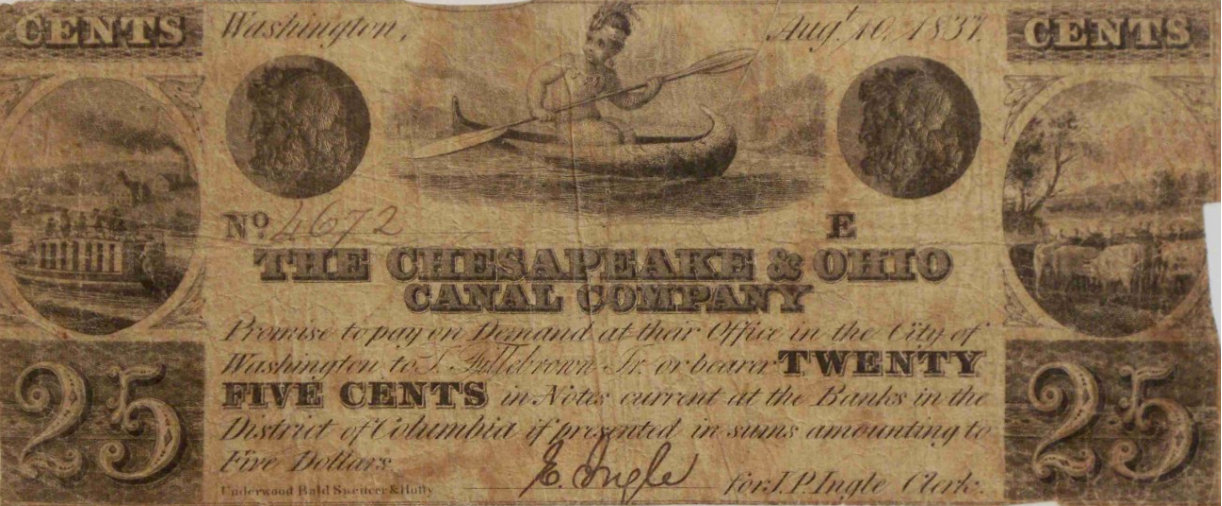
Between 1837-1841 the Chesapeake & Ohio Canal Company issued their own series of paper notes that were payable 6-9 months after the date of issue. The company’s offices, general store owners and contractors also issued fractional notes during construction in small quantities. They replaced cash payments and could only be redeemed at the store that issued them.
Between 1837-1841 the Morris Canal & Banking Company issued many notes payable at their bank in Jersey City , New York. These notes were payable with interest 12 months after the date of issue, and were “receivable for canal tolls.” Besides smaller denominations, they issued $1,000, $2,000, $3,000, and $5,000 trust certificates, but these higher valued “certificates” went unsold.
In 1838 the little known Wisconisco Canal & Coal Company of Harrisburg, Pennsylvania issued paper notes. It transported the company’s coal from Lyken’s Valley to the Pennsylvania Canal above Harrisburg.
In 1839 the Illinois & Michigan issued canal scrip in $1, $2, $5, $10, $50, and $100 denominations. They were payable 90 days after issue date. In 1840 another series that had no stipulation as to their redemption was issued by the State Bank of Chicago for the I & M Canal Fund. Canal employees started to be paid in scrip in It was redeemable in cash for half or less of its face value.
In 1840 Indiana began issuing some 1.5 million treasury notes of $5 and $10 denominations at six per cent interest to continue work on the Wabash & Erie Canal from Lafayette to Lodi, Indiana.
Wabash & Erie Canal Scrip
“Blue Pup” = One Dollar
“Blue Dog” = Five Dollars
In 1842 the White Water Valley Canal Company was so in debt it was sold to Henry S. Vallette and an Ohio company. In 1843 it issued $1, $2, and $5 notes and identifies them as certificates of stock. Even though they promised to be taken up from the bearer at the Treasurer’s Office in Connersville, they became so depreciated in value that canal laborers refused to accept them in payment for their work.
The Cincinnati & Whitewater Canal Company also issued paper notes. The Democratic Standard of June 22, 1841 showed that these notes did no better than those of the White Water Valley Canal Company:
“The Directors of the Cincinnati and Whitewater Canal company have advertised that the company is ready to pay fifty cents on the dollar on all their notes in circulation. The poor men who labored on the canal and took these notes at par in payment for their labor, will doubtless be duly grateful for the magnanimous determination of the company; when it was entirely optional with them whether they should pay the whole, one half, or nothings at all of what they, as a privileged company, had only promised to pay.”
The scrip reads as follows:
The Cincinnati & Whitewater Canal Company
Promise to pay One Dollar to B. F. Carmichael
On order of twelve months after date for value received at their office.
Cincinnati
The note dated 22 Sept 1840 is signed by the company Secretary Samuel C Foote and President Joseph Bonsall. The scrip is registered with the serial # 11440. Pictured on the right side of its face is a man walking with a dog. In the center is a local scene of a canal boat moving along toward a tunnel being constructed between Cleves and North Bend, Ohio with the farm of William Henry Harrison in the background. Harrison, at this time the Whig candidate for US President, donated the land on which some of the canal and all of the tunnel were being constructed. He was also an investor in the canal project.
Besides problems with funding, the canals had problems with labor forces; cholera; extensive damage to the canal prism, bridges, aqueducts and locks due to flooding; and competition with railroads. They limped along as best they could some for a short time and others much longer. Finally the canal era was over, railroads put them out of business.
Today sections of some of the canals have been rewatered and are used for recreational purposes. Canal scrip is sought by collectors and is worth more than during the canal era.
Thanks to Neil Sowards for the article: Schenkman, David. “Building Canals with Paper,” The Numismatist, June 2024. This 10-page article gives the history of the canals mentioned above in detail and has excellent pictures and descriptions of the canal scrip used by the canal companies.
Canal Notes #15:
Underground Railroad
Tom Castaldi
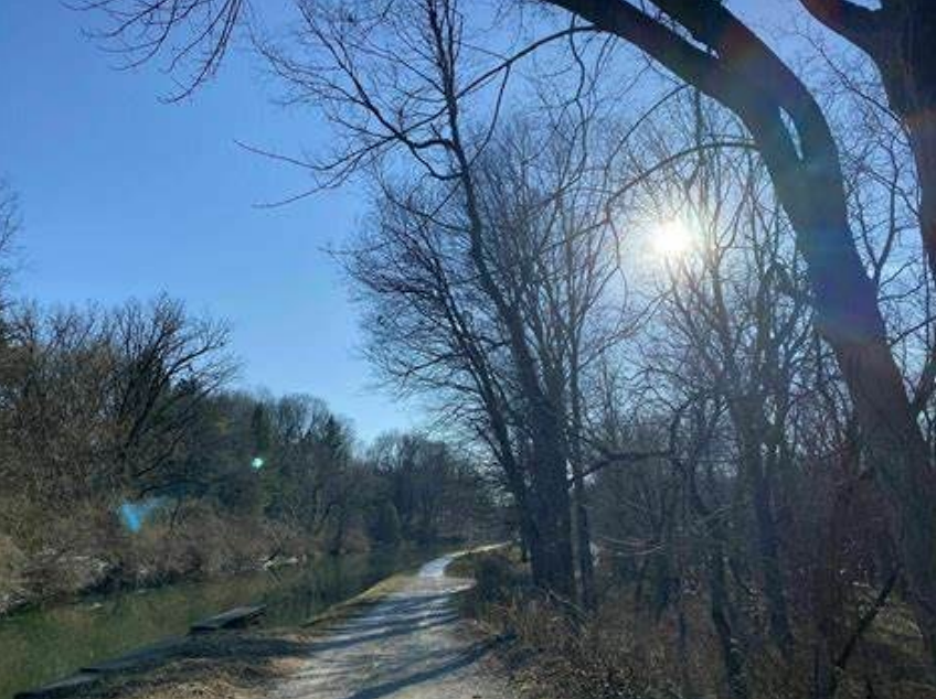
Photo courtesy AllTrails.com
Canal travelers may have depended on the towpath for mules or horses to pull Wabash & Erie Canal boats north from Evansville on the Ohio River, but there was another traveler using the tow-path route in the days before President Abraham Lincoln’s Emancipation Proclamation.
Staying out of sight, and probably using the cover of night, enterprising people escaping slavery seeking freedom found their way to the canal towpath and a natural pathway north.
It was ingenious. A clear easy to follow towpath heading north with underground railroad stations along the way where sympathetic Northerners would hide refugees from bounty hunters.
Because there were predators determined to capture and return runaways to their owners, the entire enterprise was kept a secret. To this day, few records remain to attest conclusively where sheltering stations were located.
The Klopp House* on Logansport’s Michigan Road is said to have been such a shelter. When a fugitive reached the Michigan Road where it intersected the canal at Logansport, the highway led directly north toward South Bend, into Michigan and on to Canada.
Other places were suspected underground stations such as the Vermilyea House* in west Allen County where legend speaks of a yet-to-be-discovered hidden tunnel leading from canal to house.
Canal travelers relied on the towpath to move themselves or their freight independently as they wished. For others a common towpath became a passage to an inalienable right to be free.
Editor’s Note:
*Neither of these sites are on the Indiana Department of Natural Resources “Underground” lists.
- The Klopp House on the north bank of Eel river east of the Sixth street bridge which is now (1913) used as a dwelling by Mr. Flannegan was headquarters for northern teamsters who hauled goods to Rochester and Plymouth before the days of railroads History of Cass County by Jehu Z. Powell, 1913.
- The Klopp House was also referred to as the Klopp Inn in another source.
- Jim Ellis, CSI member who once owned the Vermilyea house, thoroughly checked the basement of the house for any kind of entrance from a tunnel and found none. What was thought to be a tunnel was actually land sloped up to the back of a bank barn. If fugitives were hidden in the house, they probably entered through a door.
Godeke Acquires RR/Canal Map
Jerett Godeke
CSI Director from Antwerp, Paulding County, Ohio

Over the last couple of years, the Wabash Railroad Historical Society (WRHS) has worked with the Norfolk & Western Historical Society (NWHS) and Norfolk Southern Corporation (NSC) in repatriating materials related to the Wabash Railroad dating back to the 1800s. After several Less-Than Truckload deliveries from place of storage in Roanoke, Virginia, the material was ready to parse through at Auglaize Village just outside Defiance, Ohio.
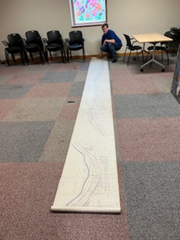
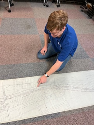
Before the WRHS took possession of the records, they had apparently been sorted by what railroad they belonged to, whether that by the Nickle Plate Road or the Wabash Railroad. This process was not perfect, and the WRHS has occasionally found some historical Nickle Plate materials interfiled with Wabash stuff, especially where the two railroads operated close to one another, such as Ft. Wayne, Indiana. Among the Nickle Plate materials was a very detailed (and very long) map of that railroad’s right-of-way from about Glasgow Avenue to Leesburg Road in Ft. Wayne. The catch, this is also a detailed map of the Wabash & Erie Canal right-of-way through downtown Ft. Wayne, Talyor’s Lock No. 3, St Mary’s Aqueduct No. 1, the canal basin west of the aqueduct etc.

Because it does not fit the collection of the Wabash Railroad Historical Society but certainly fits the collection of the Canal Society of Indiana; I was authorized by WRHS president, Randy Bible, to get this artifact to the Canal Society of Indiana to insure it went to a good home
Note:
by Bob Schmidt
After receiving this article from Jerret, there was a new transportation development in July concerning railroads that is relevant to the railroad/canal relationship. President Abraham Lincoln was always a supporter of internal improvements. As an Illinois legislator, he promoted canals (I&M) but by the time of the Civil War as President, he saw the great advantage provided by railroads. Using a common gauge between lines they could be built over most terrain and extend over great distances. Canals were fine in the East where there was a plentiful water supply, but still the West needed railroads.
In 1862 President Lincoln approved the Pacific Railroad Act. He dreamed of a continuous railroad from coast to coast. The Union Pacific Railroad was constructed from 1865-69 and stretched from Council Bluffs, Iowa to Promontory Point in Utah where it met up with the Central Pacific Railroad, which then extended on to Sacremento, California. Our own Chief Canal Engineer, Jesse Lynch Williams, was appointed to the Union Pacific Board of Directors by President Lincoln in 1864 and served until 1869.
Over the years there were several acquisitions that extended the Union Pacific rail line throughout the West. Now in July 2025 Union Pacific and Norfolk & Southern have reached a $85 billion agreement to merge both rail companies into Union Pacific headquartered in Omaha, Nebraska about mid-2026.
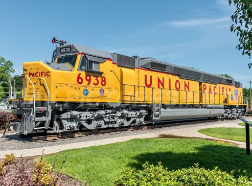
This consolidation will create a vast network of 52,000 miles of track in 43 states reaching coast to coast. It will offer shippers single-line transit for freight, which will eliminate shipping delays at key interchange points, attract more business and help jumpstart more economic growth.
This plan was just endorsed by President Trump but will still require regulatory approval.
Outreach Events & Programs

Unlocked Legacy: The Wabash & Erie Canal in Vigo County
Suzy Dunning, Curator
Vigo County Historian and Director from Terre Haute

I am putting together an exhibit about the Wabash & Erie Canal to be displayed in Vigo County History Center. I have chosen the title: Unlocked Legacy: The Wabash & Erie Canal in Vigo County.” In the narrative of personal stories, I plan to focus on how the canal impacted society and its engineering – the triumphs and setbacks as well as the failures – ultimately looking at the marvel of engineering left for future generations. What we have and use today that might have been invention of necessity for the canal. I am choosing to use a video experience that is more economical and requires less space than a canal boat model that was suggested at our CSI board meeting. The video canal can also be a research tool that can remain available in the CSI archives long after the main display is removed or even moved to the transportation exhibit on the first floor of the museum.
Envisionary Media traveled to Delphi, Indiana in late September and was able to capture footage that they needed for the video. Let me tell you, it was such an enriching and inspiring experience to visit and see the canal there in Delphi. The Envisionary Media video is going to be a clear winner for this display. We are planning to have the scene over the canal play in the background while poo-up informational “bubbles” will display more canal history around Vigo County. There may even be some voice over for the video.
My goal is to have this display finished for our “Night at the Museum” exhibit on Saturday October 25, 2025.
Dr. Morris’ Articles Republished in C & O Canal Newsletter

Several months ago, CSI Headquarters was contacted by Tim Snyder from the C&O Canal Association asking permission to reprint Dr. Ron Morris’ article about his hike along the C&O Canal that Tim had seen in “The Tumble.” Tim wanted his readers to see how others elsewhere in the United States used and enjoyed the C&O Trails. Then in the following issue of “The Tumble” he found a second article by Ron. He was given permission to reprint both articles from CSI Headquarters and by Ron. Tim then replied:
“I attended a meeting of the C&O Canal Association newsletter committee today. Yes, they want to republish Dr. Morris’s articles, probably one at a time beginning with the earliest one.
“I am going to write a short introduction to the article and include some information about the Canal Society of Indiana, which I will take from your website….”
Tim went on to ask about pictures or logos from CSI that he might use. He went on to say:
“Our newsletter is a physical print edition, not digital, although after some time pdf versions are uploaded to our website…It will help promote your canal society and educate our members about it. Our newsletter includes a lot of color images, which our members seem to like.
“Our newsletter is quarterly, so the first article will appear in Vol. 57, No. 3 (Sept. 2025). With the second article to follow in a future edition, likely December 2025. After about a year, we post old editions on our website, but they begin as print.”
Montezuma Fishing Dock
Site of the Wabash & Erie Canal
Montezuma Indiana
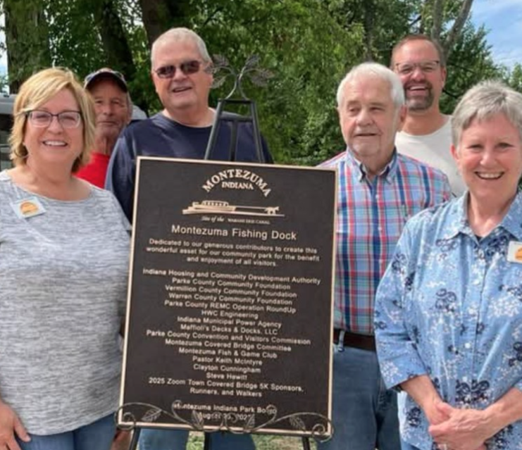
Dedicated to our generous contributors to create this wonderful crest for our community park for the benefits and enjoyment of all visitors.
Indiana Housing and Community Development Authority
Parke County Community Foundation
Vermilion County Community Foundation
Warren County Community Foundation
Parke County REMC Operation RoundUp
HWC Engineering
Indiana Municipal Power Agency and Walkers
Moffott’s Decks and Docks LLC
Parke County Convention and Visitors Commission
Montezuma Covered Bridge Committee
Montezuma Fish and Game Club
Pastor Keith McIntyre
Clayton Cunningham
Steve Howell
2025 Zoom Town Covered Bridge 5K Sponsors, Runners,
MONTEZUMA INDIANA PARK BOARD
August 25, 2025
Editor’s Note:
This new community signage is being placed in Montezuma next to our CSI sign near Benson’s Basin. Troy Jones was at the dedication of this new sign by the community park board. Perhaps our signage had an influence on the entire community.
From the Whitewater Valley
Reviewing The Whitewater Canal: A Historical Perspective
Mike Riley
After hearing about the recent problems and decisions that need to be made to save the
Whitewater Canal in Indiana, Mike Riley, President of the American Canal Society and CSI member, did comprehensive research into the past attempts to save the canal through the years. He has published his findings in the current issue of American Canals, The Bulletin of the American Canal Society Vol. LIV No. 3, Summer 2025. This article entitled “Future of Whitewater Canal in Question” is on pages 3-7 of the bulletin and includes pictures and maps. This brings national attention to the current challenge.
American Canal Society is accessible via this link www.americancanals.org.
Canal Society of Indiana
News and Programs
Tetrault Appointed to CSI Board

Mike Tetrault has been appointed to the Board of Directors of the Canal Society of Indiana to fill the vacancy created when CSI Director Phyllis Mattheis of Cambridge City submitted her resignation due to her change of address, ability to attend meetings and her age. Mike will officially be elected to the board at the CSI Annual Meeting in the spring 2026.
Phyllis has relocated from Cambridge City to Richmond, Indiana. Over her lifetime she has worked as a realtor, substitute teacher, tax person, school bus driver (13 years), and helped to maintain she and her husband Jerry’s real estate properties. She has three children, seven grandchildren (three in the military), and four great grandchildren. She has received the “Spirit of the Byway Award,” and was treasurer and editor of minutes for the secretary of the Whitewater Canal Byways Association. She applied for 3 grants from CSI to fund major WCBA projects and worked on many WCBA fund raising projects. She worked with The Whitewater Walk for 5 years. She and Jerry purchased and rehabilitated the Overbeck home in Cambridge City and created a “museum” to the Overbeck sisters. They set up canal exhibits in the Vinton House, an old National Road and Whitewater Canal Inn, in Cambridge City. She helped plan and led several CSI tours of the Whitewater Canal and the Overbeck home. She has served on the CSI board from 2014-2025 (11 years). Recently she served as secretary pro-tem for CSI. Phyllis loves CSI events and hopes to be able to attend many of them in the future.

When Dan McCain resigned from the CSI Board of Directors due to health issues, the Carroll County Wabash & Erie Canal Association no longer was represented on the CSI Board. Dan, who was born and reared in Delphi, Indiana, was graduated from Delphi High School in 1958 and Purdue University in 1962 with a B.S. degree in Agronomy. He worked as an Agronomist/Soil Conservationist with the USDA –Soil Conservation Services for 35 years. After retirement he took over leadership and spent over 25 years as a volunteer with The Carroll County Wabash & Erie Canal Association serving as president for 20 years bringing Canal Park to a nationally acclaimed volunteer park. He was the Chairman of Delphi Historic Trails. He served on the Board of Directions of the American Canal Society. Although he loved hiking and the outdoors, he now has serious walking problems.
Tetrault to CSI Board
Currently the Canal Society of Indiana is working on several major projects and it was felt that Canal Park should definitely be included in the decision making process since they are a major venue for Indiana’s canals. Mike Tetrault, the Executive Director of the Carroll County Wabash & Erie Canal, Inc. was approached and asked if he had the time and would be willing to serve on the Canal Society of Indiana Board of Directors. Mike graciously said yes.
On October 6, 2021, Mike was selected to join the work of Carroll County Wabash and Erie Canal, Inc. as its first Executive Director replacing Dan McCain, who previously was president of the volunteer organization. A graduate of Butler University with degrees in media arts and education, Mike brought his passion for learning and teaching along with his creative drive to Canal Park as he did in the past while working as a Peace Corps Volunteer in Madagascar.
He taught French and Math in the classroom. Prior to accepting his new job, Mike mentored youth; created media and music; and recruited teams of volunteers, organized, and led them at Riverside Covenant Church in West Lafayette. Mike has been a resident in Delphi for about 11 years. He is married to Autumn, also a teacher, who has a gift for design and photography. They have a daughter and a son.
Mike is now building upon the efforts of the incredible volunteer organization at Delphi. He is creating videos about the canal and those who helped construct it. He is using his skills in social media to spread the word about Indiana’s canals.
