

Index:
Canal Land in Vigo County
By Sam Ligget
On an 1857 plat map of Vigo County, Indiana, one can observe tracts of land in Prairie Creek Township labeled “Canal Land.” This canal land is as far away from the Wabash & Erie Canal as one can get and still be in Vigo County. According to Google Earth, this land is 18 miles from the nearest section of the canal. These parcels are located in the Wabash River bottoms and for the most part are either subject to flooding or are swamp and marsh land.
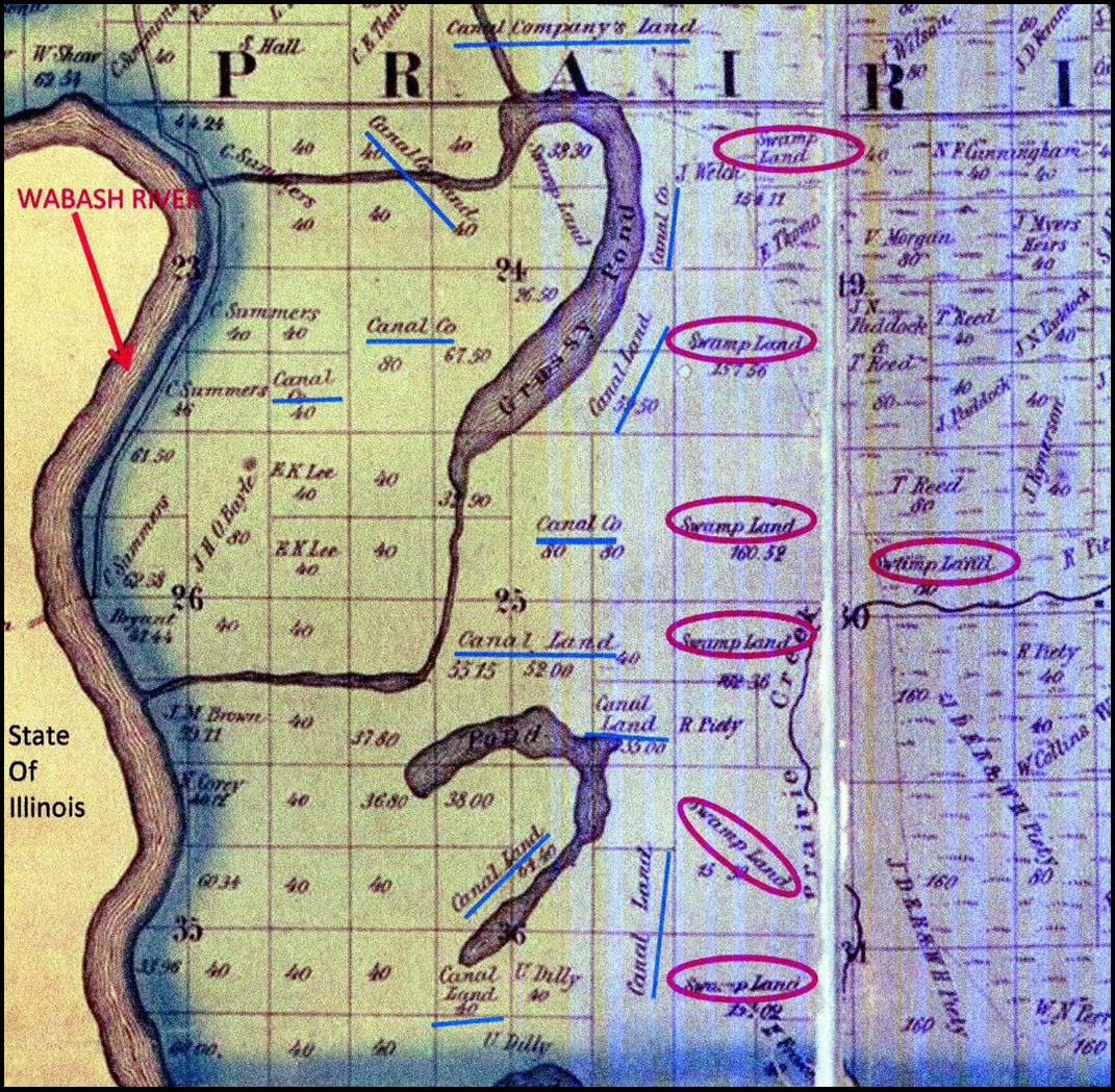
The Congress of the United States passed legislation on May 26, 1824, that provided 90 feet of land on each side of the canal to be used by the State of Indiana for a canal connecting Lake Erie with the Ohio River. Seven times Congress would pass legislation related to the Wabash & Erie Canal and land in Indiana. The last such legislation was passed in 1848.
To this day in Terre Haute, some legal property descriptions are based on the Wabash & Erie Canal survey. For example, one recent property description in the Terre Haute Tribune-Star read, “DEANS SUB West of Canal 23-1/2’ SIDE D 443/233 DC#789 7-18-93 D.”
Congress passed Statute II Chapter XII in February 1841 giving Indiana 259,368.48 acres of land to help Indiana offset the cost of construction of a canal between the “mouth of the Tippecanoe River and Terre Haute.” Section 2 states, “and be it further enacted, that should any of said lands, at the time of their selection and location by the State have other legal encumbrance, the State of Indiana shall be, and she hereby is authorized to select, any lands subject to private entry in said state other lands in lieu of so much thereof as may be so unencumbered and upon return of a description of the same to the Secretary of the Treasury, the same shall be, and hereby is confirmed.”
This statute means that the Federal Government was granting the State of Indiana land to sell to help defray the cost of constructing the Wabash & Erie Canal from Lafayette to Terre Haute. The state had the option to select other land in lieu of preemption. “In lieu land” refers to land that was still held by the Federal Government within the State of Indiana. Since this legislation was passed in 1841, most if not all of the good land in Indiana was already taken.
According to Vigo County Commissioner Brendan Kearns, men like William T. Hollenbeck of Clark County, Illinois, saw that the drainage of this land could be improved. Hollenbeck had a ditch dug across Aurora Bend on the Indiana side to straighten the river and help control flooding in Indiana and Illinois. Through the years this land became usable and thus more valuable. It was too late, though, to help finance the canal as it had already gone bankrupt.
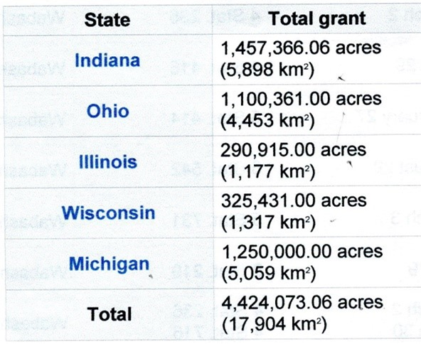
Indiana would receive a total of 1,457,366.06 acres for canal construction and maintenance. Indiana, Ohio, Illinois, Wisconsin, and Michigan received canal land in the Great Lakes region. Of the total 4,424,073.06 acres of land granted to these states, Indiana’s share was the largest at 32.94%. Michigan was second with 28.25%. Ohio was granted 266,535 acres for the part of the Wabash & Erie Canal that was constructed in that state.
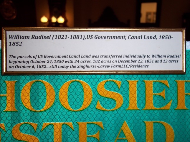
 A temporary exhibit at the new Vigo County Historical Museum contained an Indiana Farm Homestead sign with an accompanying message about the farm containing 3 tracts of canal land. This land is not adjacent to the Wabash & Erie Canal and is located in Pierson Township, Vigo County. William Rudisel purchased these 3 tracts of canal land that have remained in the family to this day. His purchases were 34 acres in October 1850, 102 acres in December 1851, and 12 acres in October 1852. In addition, William obtained from private individuals 3 other parcels that had originally been purchased as canal land. Much of this land was marked as marsh land on the 1857 plat map but is productive farm land today.
The Indiana Department of Natural Resources is in the process of buying a lot of the land labeled “Canal Land” on the 1857 map of Prairie Creek Township, Vigo County, Indiana. This land and more in West Central Indiana is being used to create a new nature preserve along the Wabash River corridor.
Thanks to Brendan Kearns, Vigo County Commissioner, for information on William Hollenbeck and the straightening of the Wabash River at Aurora Bend and to Sondra Singhurse for information on her ancestor William Rudisel.
Editor’s Comments:
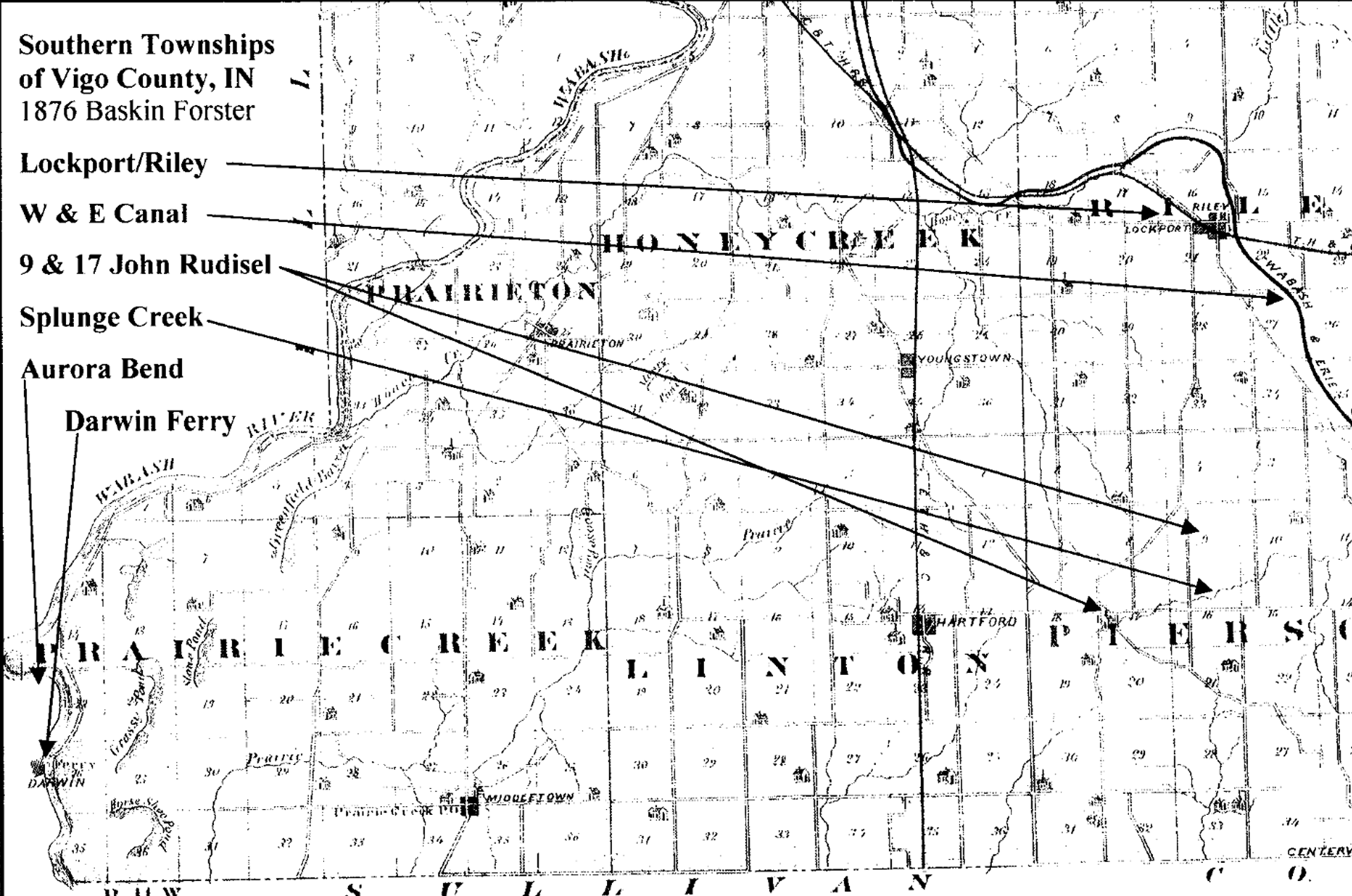
Sometimes we find property owners thinking that the canal was planned or was located on their property just because they see the words “canal land.” This article clearly shows how your property could originally be the “Canal Land” and still not be on any canal. It is interesting to hear how a savvy investor in Illinois built a drainage ditch canal in Indiana to drain swamp lands. You can see that drainage canal on the first map where it says Wabash River, at Aurora Bend.
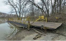
In Section 26, slightly above the drainage waterway is the town of Darwin Illinois. This little settlement is famous for having the last operating ferry boat on the Wabash. In January 2020 the ferry finally sank and washed up on the banks of the river. Talking with Sam Liggett, it still is there in the river today.
Darwin and the lands that were owned by John Rudisel can be seen on the secon map, which shows the relationship of his farm land to the Wabash & Erie Canal. The creek is Splunge Creek that becomes the Splunge Creek Reservoir when it reaches Clay County that is just beyond Pierson Twp.
1836 – Internal Improvement Commissioners
By Bob Schmidt
In the Canal Society of Indiana’s March 2020 issue of “The Tumble”, we learned about the establishment of a three-man Board of Commissioners by the Indiana legislature to administer work on the Wabash & Erie Canal. On January 27, 1836 Governor Noah Noble signed into law the Mammoth Internal Improvement Bill, expanding the scope of transportation construction projects. Now besides canals, there were also rail and waterway improvements to administer.
This new bill provided for a nine-man Board of Internal Improvements. It consisted of the three Canal Commissioners of the old Wabash & Erie Canal Board who were currently serving (Samuel Lewis, David Burr and James B. Johnson) plus six new appointees. Governor Noah Noble, recommended six men to serve on the governing board. The Senate reviewed the list — Samuel Hall (Gibson Co.), John G. Clendenin (Orange Co.), Thomas H. Blake (Vigo Co.), Gustavus Clark (Whig from Lawrence Co.), John Woodburn (Jefferson Co.) and Elisha Long (Henry Co.) The Senate confirmed all of them except Gustavus Clark, a county clerk in Bedford, who they rejected.
Governor Noble then submitted two additional names from which to choose a replacement for Clark — Jacob B. Lowe, a clerk of the Monroe County Circuit Court, or an alternate, Dr. David H. Maxwell, a physician and former legislator from that same county. On February 1, 1836 the Governor was notified by the Secretary of the Senate, James Morrison, that the Senate had rejected Jacob Lowe in favor of David Maxwell.
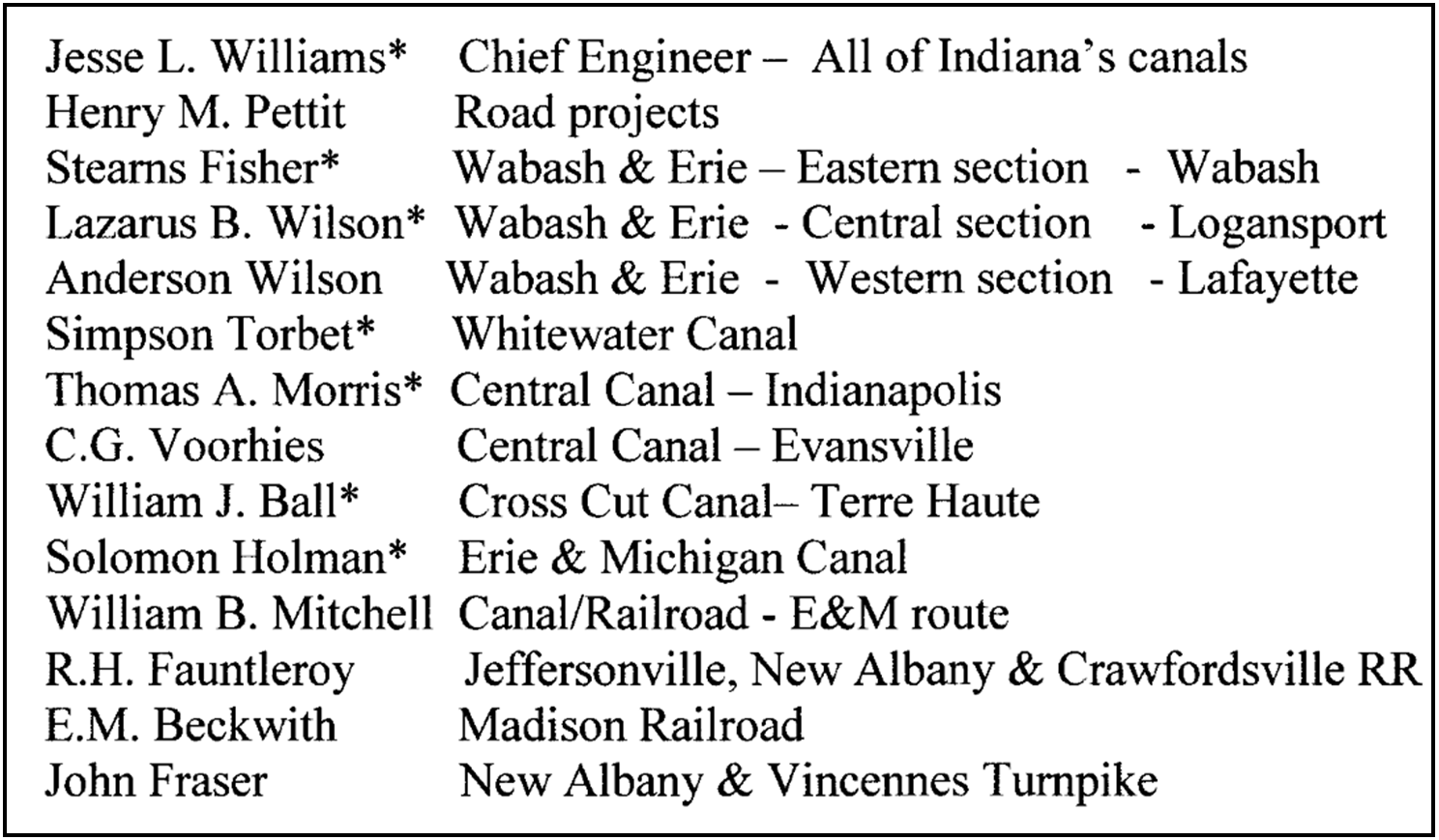
The first meeting of the Board of Internal Improvements was held in Indianapolis on March 7, 1836. Although David Maxwell was the last person selected, he was chosen as the Chairman of the Board (1836-39). The board hired Jesse Lynch Williams to serve as the Principal Engineer of Canals and to temporarily serve as Principal Engineer on Roads and Rail-ways. The latter was filled shortly thereafter by Henry M. Pettit. The board also agreed that each Commissioner would be assigned an area of responsibility among the projects. The following is a list of appointments and later replacements.
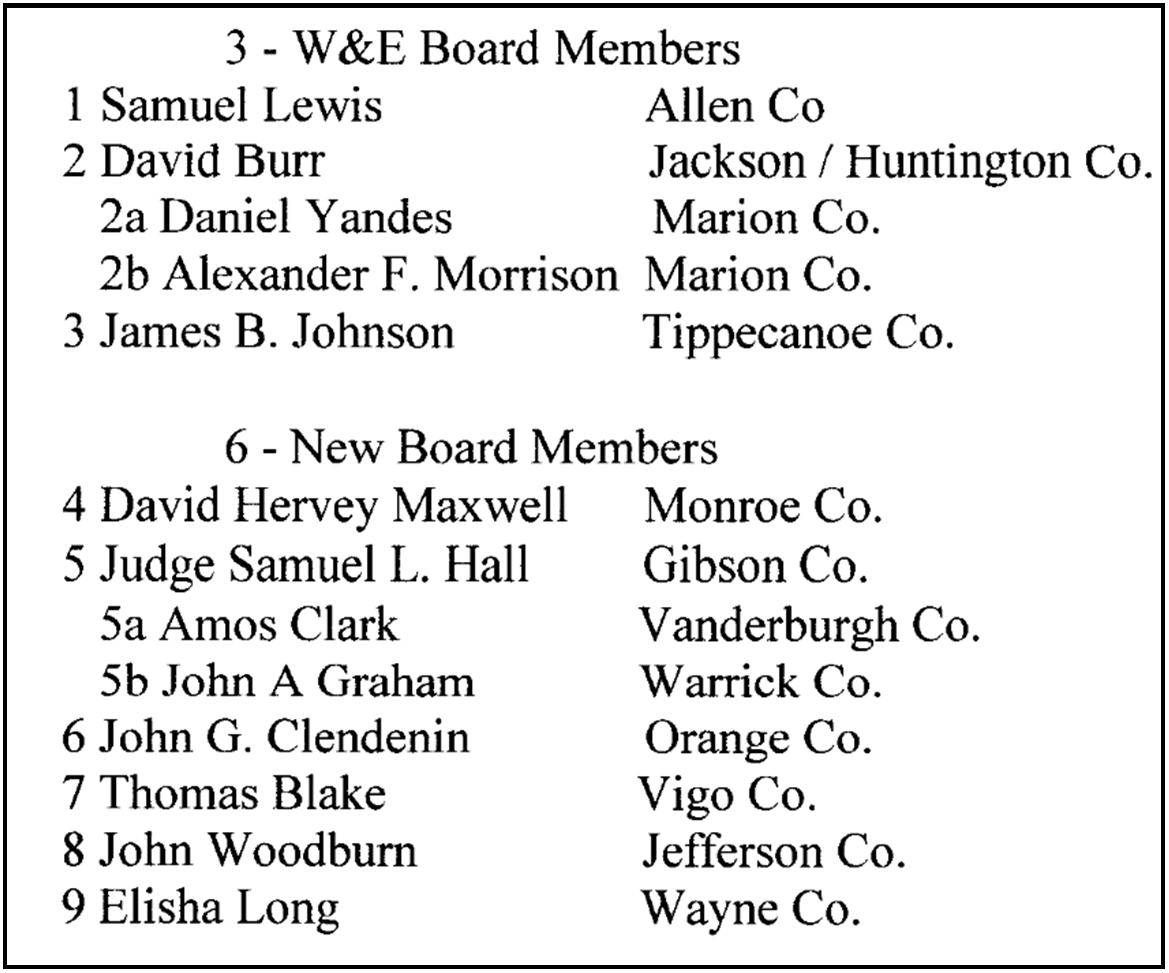
1 Samuel Lewis – W&E – Eastern section – Fort Wayne
The brother-in-law of Governor David Wallace was appointed by Governor Noah Noble to the original 3-man Board (1830—Jan. 1836). He remained on the new 9-man Board (1836- Feb. 1839) and on the next 3-man Board (Feb. 1839 – Feb. 1840) that followed. Living in Fort Wayne, he was largely responsible for the work on the Wabash & Erie Canal.
2 David Burr – Central Canal – Indianapolis
In July 1835, before the 9-man Board was established, there was a serious riot along the W&E Canal near Lagro. David Burr took the responsibility of calling in local militia to quell the rioters and subsequently occurred some expenses. He was unable to provide sufficient details for all of his expenditures and therefore was forced to repay some of them from his personal sources. Although some of his associates wanted him to remain on the Board of Commissioners, he chose to resign in late 1836. In January the following year Governor Noble offered Daniel Yandes as a replacement and was approved by the Senate on January 23, 1837.
2a Daniel Yandes – Central Canal – Indianapolis
Yandes was a logical candidate for the new Board. Originally from Pennsylvania he immigrated to Connersville, Indiana in about 1820 where he cleared land for his farm. Learning about a new state capital being established at Indianapolis, he bought land for a farm along Fall Creek and moved his family there in March 1821. He actually worked with the survey party laying out the new town. Then in 1822 he built another home on the grounds of the city. He was involved with several partners in the mill and mercantile business. He was involved in planning the Central Canal and the Michigan Road. He resigned his position of the W&E Board in Sep. 1838 after serving about 9 months. Daniel died at age 85 in Indianapolis on June 10, 1878 and was buried in Crown Hill Cemetery. FG # 84605827
2b Alexander F. Morrison – Central Canal – Indianapolis
Alexander Ferguson Morrison was born in Bath, New York on March 22, 1804. He first settled in Clark County, near Jeffersonville, Indiana. There he married Ann Owens Talbott of Charlestown on July 7, 1824. Alexander came to Indianapolis about 1829 as the state representative to the legislature from Clark County. Apparently he saw potential for a newspaper at Indianapolis for by April 1830 he was publishing the Indiana Democrat, which supported Andrew Jackson. As editor he was noted for sarcastic comments on politics and local affairs. As a Jackson supporter, he introduced a bill in the Indiana Legislature to make January 8th, the anniversary of the 1815 Battle of New Orleans, a national holiday. It did not prevail. His political outlook wouldn’t seem to make him a likely candidate for the Internal Improvement Board. However, following the resignation of Daniel Yandes, Morrison was approved by governor Noble and the Senate to fill the Improvement Board position. The position only lasted for five months until February 8, 1939, when it was reduced to a 3-man Board. Perhaps Governor Noble was trying to broaden support for the Central Canal, which was in financial distress at the time, via this newspaper editor, All work on the canal stopped in August of that year. Alexander Morrison served as a Major in the Mexican War (1846-49) and was present at the battle of Buena Vista. He died December 28, 1857 and was buried in Crown Hill Cemetery in Indianapolis. FG # 45972357
3 James B. Johnson – W&E Western section – Lafayette
Lafayette businessman James Johnson replaced John Scott, who had replaced Samuel Hanna on the original W&E Commissioner Board. He continued on the 9-man Board until Feb. 8, 1839 when that board was dissolved.
Six – New Appointments:
4 David Hervey Maxwell – Board Elected Pres. Jeffersonville, New Albany, & Crawfordsville Railroad
Born in Kentucky, Maxwell, became a physician. He married Mary Dunn the sister of Williamson Dunn, who had moved to Jefferson county, Indiana and was appointed a Judge. David and Mary moved to Indiana in 1810. David served as a physician in the War of 1812. In 1816 he moved his family to Madison, Indiana, next door to Indiana’s first governor, Jonathan Jennings. That year he was a delegate to Indiana’s constitutional convention. The family then moved to Bloomington in Monroe County in 1818. There he was instrumental in having Indiana University established in 1820. He served in the legislature as a Whig from Monroe county (1821-24) and in the Indiana Senate (1826-29). With these political connections he was appointed to the Board of Internal Improvements by Noah Noble and then by the Board to become its chairman. He served as the president of IU (1841-1852) and the mayor of Bloomington (1848-51). He died in Bloomington on May 24, 1858 at age 67. Maxwell Hall at Indiana University is named in his honor. See the CSI website for more biographical detail. FG # 28858083
5 Judge Samuel L. Hall – Central Canal – Worthington to Evansville
Originally from Maryland, Samuel Hall was a lawyer in Gibson county, Indiana. He served in the Indiana legislature (1829-31) and (1845-46). He was a circuit judge (1832-36). In February 1836 he was appointed a Board Commissioner. His area of responsibility was the southern end of the Central Canal from Point Commerce (Worthington) to Evansville. He showed little interest in his appointment and attended only one meeting. He was not even at the organizational meeting that occurred on March 7, 1836 in Indianapolis. He served as a commissioner for only a few months before resigning on September 23, 1836. Amos Clark of Vanderburgh County was nominated as his replacement, but was rejected by the Senate. From 1840-43 Samuel Hall served as Lieutenant Governor when Samuel Bigger was Governor. Later (1850-51) he participated in Indiana’s constitutional convention. He died in May of 1862 and was buried in the Warnock Cemetery in Princeton, Gibson county, Indiana. FG # 21021813.
5a Amos Clark – Central Canal – Worthington to Evansville
Amos Clark was born in Massachusetts in 1796. He was a well-read lawyer, a good counselor, fine pleader, and a man of public spirit, who was very influential in the early development of Evansville. Clark had a close association with Col. Robert M. Evans, who was instrumental in establishing Vanderburgh county and for whom the county seat of Evansville was named. Previously Evans had lived in Vincennes, Princeton, and New Harmony. He was in the Legislature. On January 11, 1836, just before the signing of the Mammoth Improvement Bill, Evans wrote a letter to Governor Noble stating that someone from Evansville should be appointed to the new Board of Commissioners. The Governor however offered the name of Judge Samuel Hall of Gibson County to the Senate and he was approved for the original board. Subsequently, when Judge Hall resigned, Governor Noble once again offered Clark as a replacement. However the Senate rejected Clark. Following the panic of 1837 Clark met with severe financial reverses. He left Evansville in about 1840 for Louisiana and Texas, where he permanently relocated. In 1848 he was a Judge in Nacogdoches, Texas. He died there on February 18, 1871 and was buried in the Texas State Cemetery in Austin. FG # 62233633. 3
5b John A Graham – Evansville section Central Canal
In December 1836 after Clark was rejected, Governor Noble next suggested John A. Graham to fill the position. This time the Senate did approve. Graham was from Warrick county, the location of the Feeder Dam on Pigeon Creek. During this period the nineteen miles of the Central
Canal from the Pigeon Dam into Evansville was constructed. This part of the canal was all at the same level so there were no locks. Although the portion from the dam north to Worthington was surveyed and planned, there was no construction. Graham was the Clerk of Warrick county. The member of the legislature at that time from Warrick county was Christopher C. Graham, who may have had some relationship to John.
6 John G. Clendenin – New Albany & Vincennes Turnpike
John Clendenin, born in 1791, was from Orange county, North Carolina. Many of the early settlers in Orange county, Indiana had come from there. Clendenin was a Whig politician, who had served several terms in the Indiana legislature (1822-27) and (1831). Clendenin was a merchant and later operated a hog packing business in Paoli, Indiana. As a merchant he had a great interest in roads and transportation. He was ideal to serve on the Internal Improvement Board of Commissioners, because he had been involved in surveying the road from Vincennes, Indiana to Louisville, Kentucky. Twenty-five miles of this toll road was actually in Orange county. This State Road was finally completed in 1839. John held numerous positions in his county. He died in Paoli in October 1849. It is probable that he was buried in the Old Town Cemetery in Paoli where his son Lead is buried. FG # 114455300
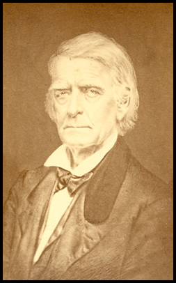
7 Thomas Blake – Cross-Cut Canal—Terre Haute to Worthington
Thomas Blake was born in Maryland on June 14, 1792. He served in the War of 1812 for the District of Columbia and fought at the battle of Bladensburg in 1814. After the war he moved west, first to Vincennes, Knox county, Indiana, where he served as its Prosecuting Attorney. Later he served as judge on Indiana’s First Judicial Circuit. He moved to Terre Haute about 1818 and was elected to the Indiana House and later the Indiana Senate. He is credited with introducing one of the first bills recommending a Wabash & Erie Canal. He served in the U.S. Congress (1827-29). In 1833 he went into a mercantile business with his brother-in-law, William Linton. In 1832 Linton had become one of three Canal Fund Commissioners. With both political and family connections it was no surprise that in 1836 Blake was selected for the Canal Board. He served the full term until this Board was dissolved in February 1839. In 1842 he was selected to serve as Commissioner in Washington City over the U.S. Land Office. While in Washington he became acquainted with the lawyer Charles Butler. Butler encouraged him to return to Terre Haute and help save the W&E Canal from its precarious financial crisis. Blake resigned his Land Office position and returned to the city. He worked with Butler and Indiana Governor James Whitcomb to get the legislature to rescue the canal by turning it over to the Trust of the Wabash & Erie Canal. Blake became the Resident Trustee of the Trust’s 3-man board. Both he and Charles Butler were selected by the Trust bond holders and the third member, Nathan Palmer, was selected by the Governor. Palmer, the State Treasurer, served only until the end of 1847. He was replaced by Austin Puett of Parke County (1848-1850). Thomas Blake, who did so much for the W&E Canal and who was influential is getting its headquarters located at Terre Haute, died of Asiatic cholera in Cincinnati, Ohio, on November 28, 1849, one year before the first canal boat arrived in Terre Haute. On July 29, 1995, CSI placed a new headstone on his grave in Woodlawn Cemetery at Terre Haute. FG # 7775455
8 John Woodburn – Madison Railroad
John Woodburn was born in Cherry Valley, New York, moved west to Steubenville, Ohio and finally arrived in Madison, Jefferson county, Indiana in 1816. He was a merchant and early promoter of the Madison Indianapolis Railroad. His area of responsibility on the Board was obviously this inclined railroad. Later after the death of his wife he moved to Mississippi and became a plantation owner. He died there in 1858 just prior to the Civil War. FG # 111570713
9 Elisha Long – Whitewater Canal
Elisha Long was born in Virginia in May 1794. He moved to Ohio and served there in the War of 1812. He married Malinda Hale in 1813 and then moved to Henry county, Indiana in 1822 where he occupied a variety of political positions. He served in the Indiana House for Henry county (1826 -1830) and the Indiana Senate (1831-1835) as a Jacksonian Democrat. He was appointed to the Internal Board of Improvements in Jan 1836. His area of responsibility was the Whitewater Canal. He became deeply involved and served as an assistant canal engineer. He also worked on surveys for the Richmond & Brookville Canal. He was the captain of the Ben Franklin, the first boat to reach Brookville from Lawrenceburg in June 1839. He moved his family to Franklin county, Indiana, that same year. His service on the Board ended in 1839 when the Board was dissolved. He died in Brookville October 2, 1842 just as work was beginning to complete the canal to Cambridge City by the privately funded White Water Canal Company. See Elisha’s biography on this website.
Additional Engineers – hired by the Board of Internal Improvements
In addition to these board member assignments, the board also selected resident engineers for all of the projects. These assignments are as follows: *See Biographies on this website
The nine-man Board of Internal Improvements was established in January 1836 for a 3-year term by Governor Noah Noble (Dec. 1831 – Dec. 1837). His appointments lasted until Feb 8, 1839 when this Board was replaced by the Legislature with a new 3-man board to serve another 3-year term. The new governor was David Wallace, a Whig who was originally from Brookville and had moved to Covington, Indiana in 1832. He had been elected and served as Noble’s Lieutenant Governor since 1831. When David Wallace was elected as Indiana’s 6th Governor he moved the family to Indianapolis in 1837.
Although very supportive of canals, Wallace’s administration was faced with the financial panic of 1837-39. Work on them had slowed and the old board was no longer required day to day. A new 3-man board was established in February 1839. Wallace offered the names of his son-in-law, Samuel Lewis of Fort Wayne, Allen county; John A. Graham of Warrick county and es-governor Noah Noble of Indianapolis, Marion county. These men were confirmed by the legislature and represented the various Canal interests of the state. In August 1839 a stop work order was issued by Governor Wallace on all internal improvements except the Wabash & Erie Canal, which still was being funded with federal land sales within the state and later by 1842 non-interest bearing notes in the form of $5-Blue dog and $1- Blue pup paper.
The state of Indiana was in a complete financial crisis by this time. After one year the 3-man Board was abolished in February 1840. It became a 2-man Board of Public Works. The members were Noah Noble and Jesse Williams, the Chief Engineer on the W&E Canal. After one year Noble resigned and was replaced by Philip Mason of Fayette county. Samuel Bigger, another Whig, became Indiana’s 7th Governor in Dec. 1840 and had to deal with the debt issue. On January 25, 1842 the 2-man board was abolished. A few months later the state owned Whitewater Canal was sold to Henry Valette of Cincinnati and became the White Water Valley Canal Company. It was headquartered at Connersville, Indiana.
Indiana was toying with the idea of complete repudiation of its debt, which had ballooned to $15 million. Charles Butler, a New York lawyer, was able to work with the legislature and establish a Wabash & Erie Trust to acquire all of the state’s property of the Wabash & Erie Canal in exchange for the existing debt. Some new bonds were issued and the trust was required to complete the canal to Evansville. A new 3-man Board was established in July 1847 originally composed of Charles Butler; Thomas Blake of Terre Haute, who was selected by the bondholders; and Nathan Palmer, the Indiana Treasurer, who was appointed by the Governor. The Governor’s appointments changed every 2-3 years from 1847-1874. A future issue of “The Tumble” will explore those appointments.
The works of the Central Canal were abandoned in place. The portion in the Indianapolis region was later sold at auction on the steps of the Statehouse to private investors in November 6, 1850.
Williams Letter to Forrer about Canal Damage Suit
Neil Sowards, CSI member from Fort Wayne, Indiana sent CSI headquarters the following letter. In it Samuel Forrer, Dayton, Ohio on Dec. 16, 1829 writes to M. T. Williams, Canal Commiss. at Columbus, Ohio. The letter was stamped Dayton, O. Dec. 17 and handwritten on the letter was Dec. 18th with a large number 20.
Dayton Dec. 16, 1829
M.T. Williams Canal Commiss.
Dear Sir: Enclosed are Sutphries [?]sects. Nos. 1281, 1282. + check 1282—
The appraisers of damages ____are now here—They had heard the whole testimony in Coopers estate case. The Guardians claim compensation for every day their water works were stopped by the operations on the canal—damages for amount of the intervention of the feeder between their millrace and the gravel bank at their head gate, and also damages for the occupancy of the ground which they had intended to occupy with their mill race at and near the old head gates—They ask damages for injuries already sustained and not for injuries in prospect—They ask no damages for water drawn from Mad river and to be used for the purpose of navigations, but only solely on their chancery claims for remuneration—one very cautions in all their movements lest their claim now before the board of appraisers should prejudice their claim in Chancery.
I find that it is not necessary to call particular witnesses to establish the fact that the estate of C. has been largely benefitted. I however made use of their principal witness W. Bostohaus and who admitted that the land at the head of the basin was not worth more than $100 pr. Acre before the canal was located and obtained from Judge Steele a schedule of lots sold in that vicinity with the prices for which they were sold – It also appears in testimony that flour is now taken to Cincinnati, on boats for 22 to 25 cents per barrel and that the prices in wagons was 50 cts – and that the flouring mill owned by the estate of C. manufactured 400 barrels of flour for years – a neat gain in that item of $1,000—abundantly sufficient to pay the whole amt. of their present claim—
The business of the canal is improving — but you will better understand to what extent by the weekly returns of the Collectors—W. Saterthwaite does not agree with the other gentlemen in the distinction they make between materials taken for the construction of the canal and land—
No failures on the canal since you left here—and I am very much disposed to feel that there shall not—
Yours respect. Samuel Forrer
SAMUEL FORRER (1793-1874)
Samuel Forrer was connected to the surveys of Ohio’s canals. In 1866 he was the resident engineer of the Miami and Erie Canal and continued as its engineer for many years. He “holds the distinction of having had the longest association of any individual with the Ohio Canal System. For over fifty years, from the very beginning of Ohio’s canals, he was variously engaged as rodman, surveyor, engineer, contractor, and Commissioner.”
MICAJAH TERRELL WILLIAMS (1775-1844)
Micajah Williams began his career as Clerk of the Board of Supervisors, Cincinnati. He then became connected with the “Western Spy” newspaper. During the War of 1812 the editor of that paper, who was a Captain in the Army, lost his life, and Micajah became the editor. Micajah married Hannah Jones on March 12, 1818. He served as a Member of the Ohio Legislature. In the 1819 session Governor Ethan Allen Brown called the attention of the Legislature to the necessity of providing some means by which the farmers of the interior could send their produce to Lake Erie. The matter was submitted to a Committee of which Micajah, then a Member from Hamilton County, was Chairman. A Bill was passed authorizing two canals, one from Cleveland to the Ohio River and one from Cincinnati north to Maumee Bay. Micajah was Speaker of the Assembly when this Bill was passed. At the end of his term as Speaker he was appointed by the Governor of the State to the Board of Canal Commissioners.
In 1832 he was appointed by President Jackson Surveyor-General of the Northwest Territory, to fill the vacancy caused by the death of General Lytte. He served as a Director of the Ohio Life Insurance & Trust Company, and later became its President. In 1832 he went to England to negotiate the sale of the Ohio State bonds.
 Micajah was a candidate of the Democratic Party for United States Senator opposing Thomas Ewing, who was chosen to that position by the Whig Party. In 1840, when General William Henry Harrison was the Whig candidate for President, Micajah left the Democratic Party to become a Republican giving as his reason that the Tariff, which the Democratic Party opposed, was a necessity for the People, and that the Democratic Party was much more of a Southern than a National one.
During Micajah’s services as Surveyor-General, Byron Kilbourn was made Surveyor of the Government lands in Wisconsin. Soon after his appointment Micajah said to him in course of conversation: “Somewhere on the western shore of Lake Michigan between Fort Dearborn (now Chicago) and Green Bay there must some day be a great city. As you work along that shore examine it thoroughly, determine where that city will be, and I will join you in the purchase of the land and lay out the city.” The mouth of the Milwaukee was chosen. At the first sale of Government land, the land on the west side of the Milwaukee River was purchased, soon after the city of Milwaukee was laid out, and later the lots were divided in equal numbers between Kilbourn and Micajah.
Micajah T. Williams died in 1844 at the age of 52 years. He was the older brother of Jesse Lynch Williams, who became the chief engineer of Indiana’s canals.
1834 Erie Canal Trip
In 1993 Webster Hall, CSI member from Richmond, IN, found and sent the following letter to CSI Headquarters that was written by one of his ancestors about her trip on the Erie Canal.
Monroe, Ohio, June 24, 1834.
Tuesday P.M.
Dear Sister:
After a week and one day’s absence from home, I have found time at last to write. You will perhaps like to hear some account of our journey here. We left Burlington 9 o’clock Monday evening, and arrived at Whitehall Tuesday morning at 7 o’clock. From thence we took the stage to Saratoga, [NY] (thinking it to be the more expeditious way). After we arrived there we visited the Springs and drank bountifully of its waters, but were not conscious of experiencing any material benefit or injury thereby. Saratoga is a most delightful village, some of the most beautiful buildings here I ever saw. We stopped at this place an hour or two, and then took passage in the steam cars for Schenectady. The railroad itself and cars are no great curiosity, but to see them in operation is quite curious. We traveled the distance of twenty-one miles in two hours, including stopping places. Our flight was so rapid that I was fearful it would affect our nerves and cause sickness, but it proved quite the reverse. Indeed if we had been unwell we could not have realized it. Imagine to your self a string of carriages or cars fifteen rods in length, moving with such velocity without any perceivable power, and you will have some idea of railroad cars. On Tuesday evening at 8 o’clock went on board a canal boat, which we called home. We passed through many flourishing and handsome villages, some of them very romantic, the village of Little Falls, for instance. It is entirely surrounded by mountains, and contains three or four houses of public worship. Here the canal is cut through a solid rock upon one side for a mile and a half and the Mohawk River on the other. The canal is fifty or sixty feet higher than the river, and a wall is built upon the bank that height. It is a great curiosity. We were deprived of the privilege or seeing Utica, having passed it in the night. The country for sixty miles beyond Utica is unpleasant; being very low and marshy, and filled with swamps. Every six, eight or ten miles a little village has sprung up within a few years. After passing Montezuma we entered a large marsh three miles in width, over which a bridge is erected for the horses to pass over. This place has the appearance of a pond or creek. The next large town we entered was Syracuse. Here was grandeur itself. It was just at sunset when we entered this place. The scenery was beautiful beyond description. Each side of the canal is lined with lofty buildings from three to four stories high. There the Oswego Canal intersects the Erie. One mile and a half north are the salt works of Salinas. Here the country begins to assume a handsome appearance. Spent the whole day and had an opportunity of walking about the streets and seeing a good part of the city. It is said to contain 15,000 inhabitants. It was certainly the largest city I ever was in. Here every stranger that arrives visits Genesee Falls. Of course I did. These falls are rendered doubly interesting from the fact that Sam Patch made his last leap here. I was shown the place from whence he jumped, and thought what a preposterous being was man. The falls are of a circular form. The river is perhaps a hundred rods in width. There are eleven places of public worship, and another elegant building called The Arcade. We left Rochester 7 o’clock and Sunday night at the same hour entered Lockport. Here I suppose is one of the greatest works of art that perhaps is in the United States or in the world. Half a mile below the village the canal is dug between two high hills till we get to the locks. Here we rise sixty feet from one lock into another in the space of ten rods. We walked all over this place, for we were almost afraid of staying in the boat for fear of its being filled with water. But I suppose there was no danger, as the boat went through without any difficulty. Here the canal is cut through a solid rock for three miles, being just wide enough for boats to pass. The wall on each side is twenty or thirty feet high. I stood upon deck a good part of the time in going through this place, for I thought it a great curiosity and I was resolved to see all that was worth seeing. Monday morning at sunrise we found ourselves on the bank of Niagara River opposite Grand Island. In a short time we came to Black Rock, a pretty little village opposite Fort Erie in Canada. The river here has the appearance of a lake. Going three miles further we entered Buffalo, the great emporium of the west. We were glad to leave the canal, for it is a dirty place as I ever saw, but the accommodations are very good. We stopped in Buffalo about two hours, waiting for the steam boat. This place commands the handsomest prospect from the lake I ever beheld. At nine o’clock we left the harbor, and for the first time had a view of Lake Erie. It is the most beautiful expanse of water imaginable, of a palish green color, and as the sun shone on it gave it the appearance of so many rainbows. It was a perfect calm in the forenoon, and the scenery was almost enchanting. We went upon the upper deck where we could have a view of Canada, Niagara River and New York State on the south. The lake grows wider as we leave the harbor, and we had a full and perfect view of the whole city as far as the eye could reach. In ten and a half hours from the time we left Buffalo we landed at Conneaut in Ohio, a distance of one hundred and twenty miles at the rate of thirteen miles per hour. It was about dark when we got to land, so we put up to a tavern over night, and the next morning about six o’clock, came to our Uncle’s in Monroe. Found them all in good health and glad to see us. They have two children at home whom I like very much. Aunt appears and looks very much as I thought she did. I was apprehensive our journey would be too fatiguing for father and mother, but they endured it remarkable well. The first night we came on to the canal mother was some unwell, but since that time has not been troubled. Slept just a well as she ever did. Father is just the same. They are not willing to return till we have been to Cincinnati. Our expenses have been considerable, but hope we shall have sufficient to carry us through. I have not had a chance to see much of the country in Ohio. The greatest difference I know is that the sun rises in the South and sets in the North. We have wished a number of times that our whole family were with us, we should not return. We like the country much. If Alpheus or Lorenzo would take a journey into these parts of the world I think they would not repent it. For my part I don’t value the expense though I should pay it myself. My own health has been excellent. The day we spent in Rochester I had a turn of being seasick in crossing the lake but never felt better. We have had good company a greater part of the way, some going to Michigan, some to Cincinnati and to every other place. We shall return home probably by the first of August. We shall take the stage at this place for Pittsburgh, it being the cheapest and shortest route. We shall arrive in Cincinnati three days sooner than by going on the canal. Probably by the time you get this we shall be there. Hope you will not be uneasy about us. If any of us should be sick we shall write again.
Yours &C
Caroline Hall
W & E Feeder Dam at Lagro, IN
In the winter of 1984 the Wabash County Historical Society Newsletter carried an article by Dr. Arch Porter entitled “Early Recollections of the Lagro Dam and Environs.” The parts of the article pertaining to the feeder dam, the river and canal bridges, and the canal are quoted below. For further information about Lagro see the July 2020 issue of “The Tumble.”
“My first recollection of the [canal feeder] dam was that the old girl had lost her apron. It had been in the wash too long; it had washed away. But she was a good old dam yet, doing her stuff sans apron. Backing the water approximately four miles almost to the Belden Dam and creating one of the most beautiful bodies of water imaginable. The old timbers, that formed the base of the apron, were still in good condition and could be seen only in low water.
“The timbers forming the back of the dam remained intact for years but finally gave way to the ravages of time, rushing water and heavy ice, and her death blow, the cruelest of all, was given by man with dynamite. The old girl could have battled natural forces for may years more but she stood no chance with man.
“The purpose of the dam was to act as a feeder for the [Wabash & Erie] canal; the feeder gates being located just a few feet west of the present Interurban Station. [CSI has erected a marker at this spot.] The dam was located directly beneath the [Wabash] river bridge and if interested, you may in low water, still be able to locate some of the sleepers; rugged old hewn timbers that still defy the ravages of time and water.
“The bridge was of the old wooden type and at either end was a sign which read ‘Five dollars fine for driving across this bridge faster than a slow walk.’ So you see we had our ‘Speed Limit’ signs in those days also.
“Above the dam was an island the lower end of which was approximately one hundred and fifty feet distant; the current was swift and rowing a boat across the river between the dam and the island wasn’t the safest proposition in the world. At the east end of this island, on the south side was a sort of bayou, a rather secluded spot where you might swim in you ‘birthday’ clothes. It was at this spot that Leander Stratton, brother of Gene Stratton, the authoress, was drown.
“The apron of the dam is an inclined plane, of about forty five degrees, at the bottom of which is a level platform three feet wide that causes the water to flow directly forward and not wash out the river bed in front of the dam. When the apron was gone the water had a direct drop over the back and the continual pouring of these tons of water, knawing [gnawing] at the river bed, scooped out great slabs of stone, piled them up in a neat row about sixty feet below forming a basin, which between the middle and south piers, was twenty to twenty five feet deep. Between the middle and north piers the rock was apparently harder and did not wash so deeply.
“Occasionally in extremely dry weather, there was little or no water going over the dam except at a place about twenty feet from the south end where it had begun to sag a little. But for the most part of the year there was a heavy flow. I am speaking of the time when the river was a river and not a creek as it has been for many years. During the time of heavy flow the water is going over, broken into two currents; the upper current going out a short distance then washing back toward the dam. The lower current going directly out and rushing over the pile of stone, forming what was locally know as the ‘riffles.’
“Woe unto man or beast that went-over the dam and failed to make the lower current, which was seldom. Logs going over would roll in the back wash for hours or until they came back endwise, were upended and driven into the lower current.
“Beef cattle and hogs did not ride to market in limousines as they do today; they came under their own power, hitting on all four hoofs. In bringing herds from the south to the Lagro market the bridge presented a sort of a problem to the herd drivers. A congestion at the end of the bridge sometimes caused a stampede and some unruly animals would break ranks and use their own judgment about crossing. It they decided to cross below the dam, very good. But if they chose to cross above; it was their last bath. Perhaps from the animal’s stand point it didn’t make much difference, they were going to their death anyway, but they should have had a little consideration for their owners because a beef or hog rolling in that backwash for hours or a day wasn’t worth a lead nickel.
“A pal of mine, living south of the river had a Spitz dog, this dog was well taken care of, always washed clean and looked like a living chunk of snow. On day Spitz thought he would show ‘Old Man Ribber’ a thing or two by swimming across above the dam. When ‘Ole Man’ got through with Spitz he was all washed up in more ways than one. He was still in the backwash at dark. I came down early next morning but the lower current had claimed him some time during the night and Spitz, by that time, was peacefully wending his way toward the Atlantic Ocean.
“This dam was a fisherman’s paradise. There was no stale water, it was clear, sparkling and swift moving, restless as the modern youth, always going places. It was the playground of the fighting, plunging small mouth bass and when you hooked one of those fellows in that swift water you had a fight on your hands. The river at this point was teeming with them, if you couldn’t catch four or five nice bass before breakfast you weren’t even considered a fisherman.
“The part of the river above the dam was deep enough that a boat, which did not draw much water, could ply between Lagro and that once famous resort, the Hanging Rock. Picnic parties at the Rock were all the rage in the late 80s and if your party was too numerous for all to make the trip at once, you divided, some waiting for the next trip, or if you were in too much of a hurry you could walk, it was only a mile.
“The dam not only furnished excellent sport in the summer but winter as well. A sheet of ice several miles long furnished an ideal place for skating, also a supply of ice to cool the beer in the seven or eight saloons of that day. Lagro had numerous fast and fancy skaters who could compete with any in the country. ‘Shinny’ was the favorite ice game. Shinny played in a cow pasture goes by the dignified name of golf, but for real sport ‘gimmie old time shinny.’
“Sharp shod horses, hitched to sleighs, driven over the ice gave you a real thrill and a horse with a single tree to which was attached a long rope with all the kids who could get hold hanging on, was another thriller.
“In the spring of the year, when the rains commenced and the river began to raise, we were all agog, hoping the ice would go out in the day time. Picture in you mind that block of ice several miles long, bank to bank wide and twelve to fifteen inches thick rousing from its sleep and starting on its westward journey.
“Adjectives haven’t yet been coined that would adequately describe this spectacle. The middle pier of the bridge stood directly in its path. With a crunching, grinding roar, that could be heard for a mile or more, these great blocks of ice battered and battled with the pier, striking it with tremendous force, piling against it in great masses that it seemed nothing could withstand and at times people were forbidden to be on the bridge lest the pier should give way. This pier, although in recent years re-enforced with cement, still stands, a monument to the pioneer builders.
“There was a wooden bridge across the canal, angling the same as the present road crossing. A Frenchman had a dwelling at the south east corner of the bridge. His shop stood on the walled bank of the river about fifty feet from the north end of the river bridge on the west. He needed water power, so he built a flume from close to the dam, running along the base of the wall. He dropped a shaft, upon the end of which was a water wheel. But did she work—s-h-e-did.
[One day] “I put on my ‘Sunday go to meetin’ pants and waist. Having been given no orders to stay home I slipped away. Instead of going down and crossing the canal bridge to the river I decided to use a foot bridge just a little to the east of our home. This bridge was just two long planks supported by a trestle in the center . [Wanting to see how deep the water was in the canal] at the trestle I shoved a cornstalk down to the bottom, the stalk broke and I pitched head first into the canal. [I came home looking like a drowned rat.]
“That footbridge served a dual purpose; it was also a fruit stand. Several groceries had their back doors on the canal bank and the canal was a common dump. All refuse was thrown into it but the refuse we kids were particularly interested in was half rotten oranges. When these came floating down we were on the job at the footbridge fishing them out, cutting the rotten part away and putting the rest where it would do the most good.
“The canal was another scene of winter sport. The current was slow and the bank acted as a wind break so the water did not ripple to any extent and it would freeze ‘as slick as glass.’ Skating to Wabash was some sport for us as well as to the Wabash boys skating to Lagro.
“Just south of the present Lagro High School Building there was, and still is, a wide place in the canal called the basin. In this basin a boat was left to its fate. The cabin of the packet was a ‘rendezvous’ for older boys and men who wished to indulge in that great American pastime—poker. The packet boat, which was just below the hill from our home, was later taken apart by a man name Watkins and the timber appropriated to his own use. The hull remained visible for many years.”
Metamora: Historic Site to be Updated
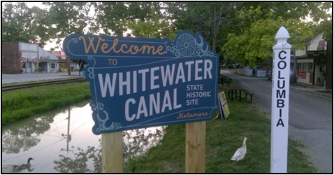
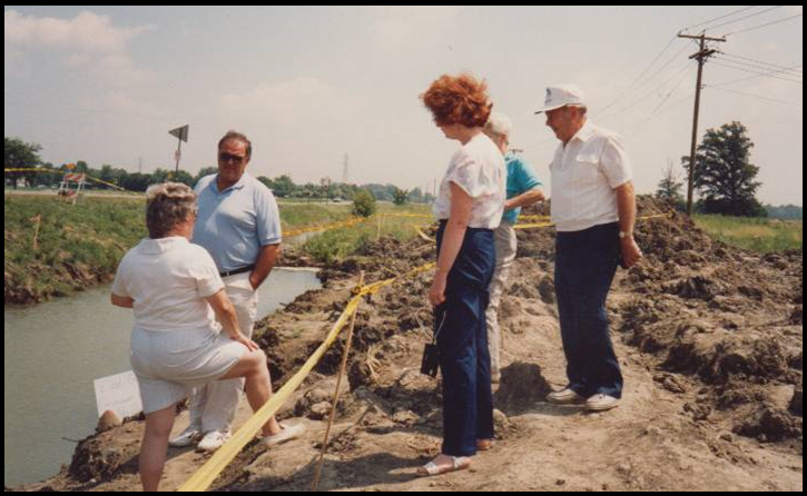
On May 23, 2020 a disgruntled resident of Metamora, Indiana, Tom Smith, placed a photo of the Ben Franklin III, a replica canal boat, and the run down town on Facebook that was taken over Memorial Day weekend. After seeing his post other community members voiced there concerns over the lack of general upkeep and maintenance of the Whitewater Canal state historic site located there. One of the local shop owners posted a letter he had sent to Governor Holcomb about two years ago in regards to the condition of the site and said he had attended a meeting with a team from the Indiana State Museum and Historic Sites thereafter. But nothing had really changed. On May 26, 2020 Smith contacted the state again and by May 26 a meeting was organized to be held at the grist mill in Metamora.
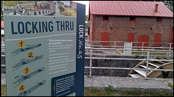
Metamora residents and shop owners met on May 28 with James Sved, the vice president of Historic Preservation and Operations. He said a grant had been pursued on behalf of the Whitewater Canal State Historic Site the previous year and $250,000 had been received from the tourism department to make improvements to the mill and to the site in general. This was news to those attending the meeting. Sved said the delay was due to the virus shutting down the entire state and the extensive rain also delayed progress. Originally the project was scheduled for completion with the mill and canal opened by the beginning of April 2020.
Sved went on to state the projects that had been completed: interior painting, a slat wall installed and the old entrance covered on the mill; a bathroom updated for handicap use; two storage rooms rehabbed for guest access to the mill; historically inappropriate cabinets removed and additional lighting put in place in the mill. Yet to come: new uniform signage showcasing the historic site with eleven signs placed along the 14-mile section highlighting the history of the building of the canal, the aqueduct, etc and 18 news signs placed throughout the mill showcasing history; painting of bridges, handrails, etc. along the canal; the installation of cedar-covered benches and outdoor picnic tables; new trash cans; landscaping; and installing interactive displays for children. He also said that although fixing or replacing the water wheel for the mill was being explored, at the moment there were no funds available or no timetable as to when that might be accomplished.
In Memoriam
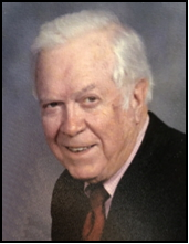 Charles (Chuck) A. Whiting, Jr.
Charles A. Whiting, Jr., 93, passed away on Friday, June 12, 2020. He was born in Boston , Mass., to Charles A. Whiting Sr. and Martha Elizabeth Harton Whiting on February 26, 1927. The family moved to Lakeside Park, Kentucky, where he attended Beechwood Elementary School and Dixie Heights High School . He joined the Navy following his junior year and received training in electronics. Upon his discharge, he enrolled as a student at Purdue University, under the GI Bill. There he studied electrical engineering, and was inducted into the honorary engineering fraternities Tau Beta Pi and Eta Kappa Nu. He was also a member of Pi Kappa Alpha.
Charles married Anne Baker Watts on September 3, 1947, in Harrodsburg , Kentucky . They lived in West Lafayette. He received an electrical engineering degree in February 1949, and was hired by the Aluminum Company of America (Alcoa) in New Kensington, Pennsylvania. The next 40 years were spent with Alcoa in several plants and in the main offices. His work as an engineer took him to Europe and Central America.
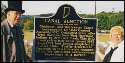
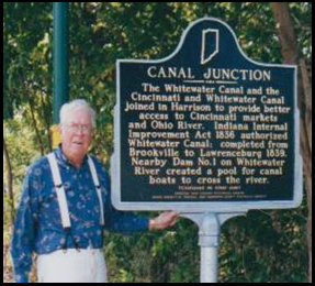
Chuck loved history. He was an active member of the Canal Society of Indiana where he served as a director, led or helped with canal tours on the Whitewater Canal and was instrumental in getting a two-sided Indiana Historical Format Marker placed at West Harrison for the junction of the Whitewater and the Cincinnati-Whitewater Canal. He will be missed.
After his retirement, Chuck volunteered for over 20 years at the Cincinnati Museum Center talking about steamboats and canals. He served as president of the Dearborn County Historical Society. He also belonged to Trinity Episcopal Church of Lawrenceburg.
Charles was preceded in death by his parents; his son, Charles Mark Whiting; grandson, Jason Watts Whiting; and his two brothers, William Harton Whiting and Richard Earl Whiting. He is survived by his wife of 72 years, Anne Watts Whiting; daughter, Susan Anne (Whiting) Steigerwald; son, James Harton Whiting; son-in-law, David Lawrence Steigerwald; grandchildren, Peter Charles Steigerwald and Jane Anne Steigerwald; and his nieces and nephews.
Private graveside services were held at 10 a.m. Tuesday, June 16, 2020, at Spring Grove Cemetery with The Reverend Mary Taflinger presiding. Memorials may be made to Trinity Episcopal Church of Lawrenceburg, the Canal Society of Indiana, or the Dearborn County Historical Society.
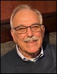
James (Jim) Walter Hicks
James (Jim) Walter Hicks, 83, died on June 22, 2020 following complications of COVID-19 in Brazil, Indiana. Hw as born in 1937 to Keith Kenneth and Mary Ruth (Adair) Hicks at the home of his grandparents in Ligonier, Indiana. He graduated from Cromwell High School in Noble county, Indiana, attended Purdue University and served 3 years in the U.S. Army—one in Korea. In 1960 he married Goldie Blanton. They were 1 month shy of celebrating their 60th wedding anniversary.
 Jim enjoyed a career related to farming working with Massey Ferguson, teaching tractor maintenance and safety and serving as a western wheat combine technician; Quaker Oats (feed sales), Brazil Co-Op (feed sales), and retired from Growers Co-Op as an animal health and feed specialist in 1996. He earned many sales awards and was honored in 2004 as the Brazil Chamber of Commerce/Brazil Times Focus award for volunteerism. He was a former owner of Brazil Pizza King and Hicks Tassel & Supply. He also worked briefly for Household Finance in Lafayette, Indiana. After retirement he drove a bus for Clay Community Schools.
Jim was a member and past president of the Canal Society of Indiana at the time the Gronauer Lock was unearthed. He helped inform the public about the importance of the lock. He then became CSI vice-president. He helped plan society tours of the Cross-Cut Canal in the Terre Haute area. He and Goldie enjoyed wearing canal era clothing for CSI tours and special events.

Jim was a leader. Over the years he belonged to the Brazil Historical Society (president), Sons of American Revolution (president), Preservation Society of Clay County (president), Brazil Housing Authority Board, Clay County Farm Bureau Credit Union Board, 4-H Extension Board, Indiana State Fair Found Barn Board, National Road committee, Clay County Historical Society, toastmasters Blub, Indiana Studebaker Club, volunteer fireman (Wanamaker, IN), Herald of His Coming volunteer, Tractor/Horse pulling judge and member of VFW.
Jim was a Deacon, Elder, trustee, church bus driver, and grounds caretaker for the First Christian Church, Brazil, Indiana. He accompanied many youth groups on trips and invited them to his home.
He enjoyed traveling. He and Goldie visited Mexico, Panama Canal, Haiti, Dominican Repuiblic, France, Germany, Australia, Puerto Rico, Chec Republilc, England, Scotland, Ireland, China, Italy, and all 50 United States.
Jim was preceded in death by his parents, Keith and Mary Hicks, of Ligonier, Indiana. He is survived by his wife, Goldie, of Brazil, IN; brother Tom (Tina) Hicks of Brick, NJ; children, Dr. Lisa (Lori Ball) Hicks, Indianapolis, IN, Bradley (Wendy) Hicks, Louisville, KY, and Derric Hicks, Indianapolis, IN: and grandchildren, Luda, Alex, and Mar’yana Hicks, Michael Cocanougher, and Matthew and Joe Meyer.
A celebration of life was held Thursday, June 25, 2020 at 11:30 a.m. in the Forest Park Pavilion (Cow Palace), Brazil, Indiana. Memorials may be made to First Christian Church, Brazil, Indiana.
Memorials Received
CSI has received memorials to Chuck Whiting from James Hamill and Bob & Carolyn Schmidt
CSI has received a memorial to Jim Hicks from Bob & Carolyn Schmidt
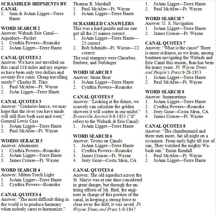
Canal Word Puzzles
CSI members have received puzzles by E-mail during the Coronavirus quarantine. These have been scrambled canal words, canal word searches and canal quotes. The July issue of “The Tumble” had the winners of the first three puzzles. The following members have been the quickest to send in their correct answers for the next 16 puzzles to CSI Headquarters:
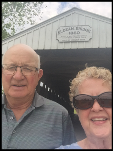
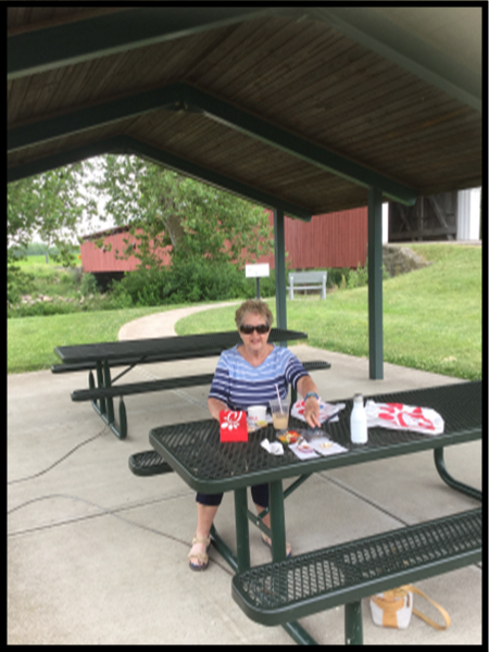
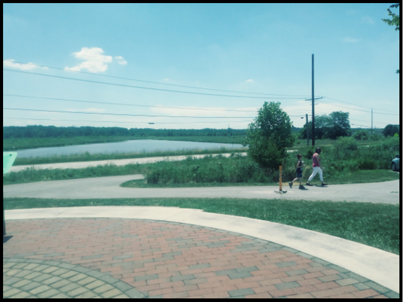
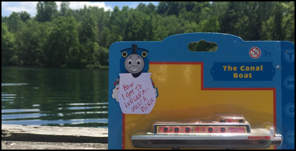
International Picnic Day June 18
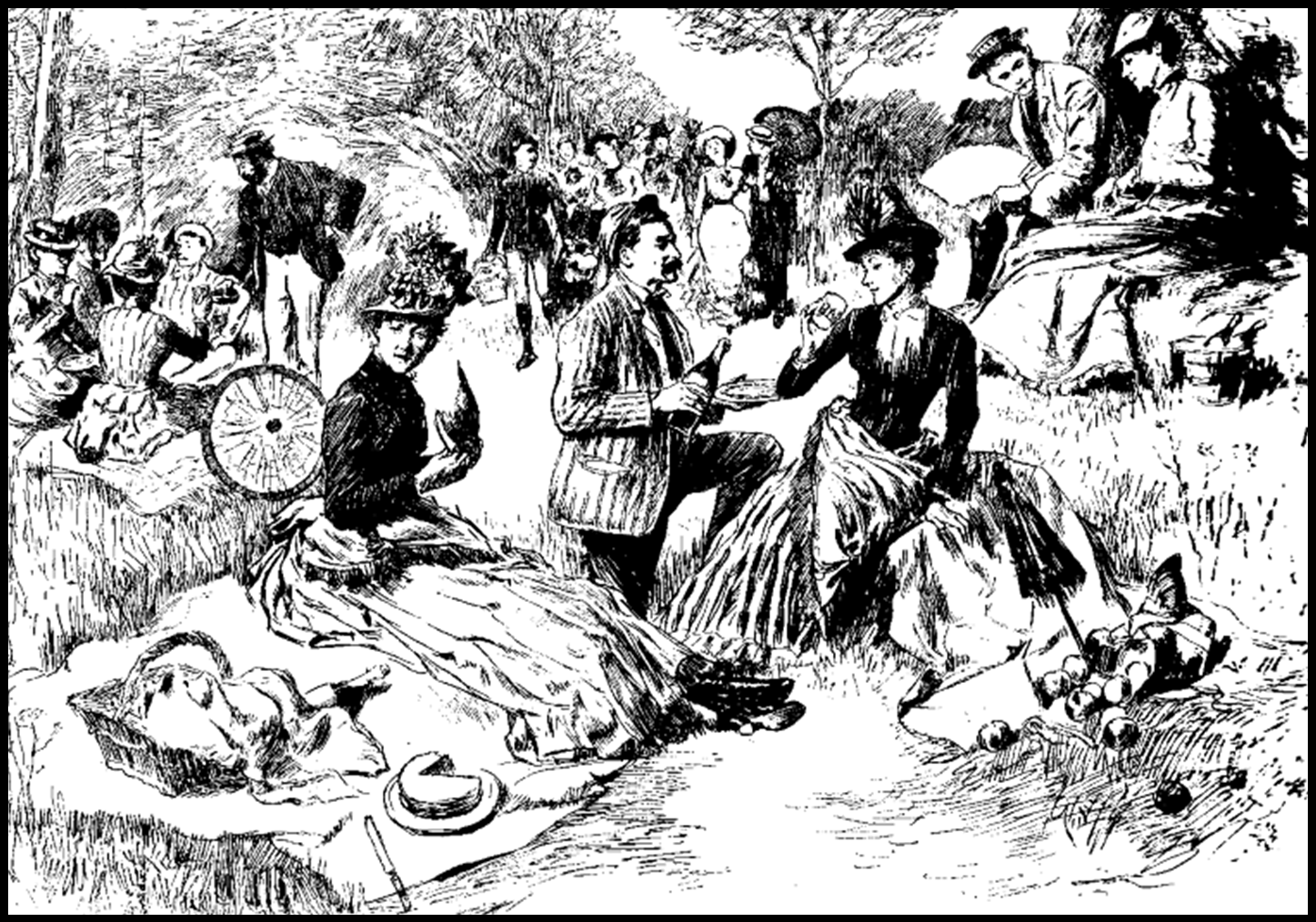
Since CSI members had been “cooped up” for weeks during the quarantine and the weather had turned nice, Bob Schmidt thought canawlers should celebrate International Picnic Day by taking a picnic basket to a canal site, taking their picture at the site, sending it to CSI headquarters and headquarters would E-mail them to members to keep everyone in touch with each other.
In his daily post of This Day in Indiana History, he explained that International Picnic Day can be traced back to the end of the French Revolution and the Victorian Era. The picnic was most likely invented by the French. Shortly after the French Revolution ended, the Royal Gardens were opened to the public for the first time. Although an unofficial holiday, on June 18 each year International Picnic Day celebrates gathering together outdoors to eat and enjoy one another’s company, which has traditionally been called Picnic.


Hagerstown-Whitewater Canal Sign-Cambridge City

Phyllis Mattheis, CSI director from Cambridge City, recently found a picture that was taken when the present sign along Boyd Road by the Hagerstown Extension of the Whitewater Canal was new. The vertical metal sign was mounted on a metal post planted right next to the road.
It said:
A Section of the
WHITEWATER CANAL
Opened 1845-1865 Abandoned
76 Miles 55 Locks 7 Dams
CAMBRIDGE CITY TO
LAWRENCEBURG, IN
On The Ohio River
30 feet Wide at the base
40 feet Wide at the surface
4 feet Deep
Erected for Hoosier Celebration 88 By
WESTERN WAYNE HERITAGE, INC.
Although the sign had lots of information, it was too much to read when passing by. CSI will install one of its new signs nearby and hopes to find a place where a vehicle may pull off to read the sign.
World Canals Conference 2021
By Bill Holdsworth, C&O Canal Association
The Chesapeake and Ohio Canal Association is getting ready to welcome canal enthusiasts from around the world to next year’s World Canals Conference August 30-September, 2021 in Hagerstown, MD.
The COVID-19 pandemic has cast a cloud over the preparations. Leipzig, Germany was scheduled to host the 2020 conference in September, but the impact of the pandemic forced them to reschedule for May 2022.
We will monitor developments over the coming months. We are hopeful that conditions will improve and that canal lovers will be ready to gather again.
We will be celebrating the 50th anniversary of the creation of the C&O Canal National Historical Park. Construction of the C&O Canal began in 1828 in Washington, D.C. The canal reached Cumberland in 1850. It operated until 1924. The federal government acquired the disused waterway in 1938. Legislation transformed it into a national park in 1971.
Conference theme will be:
- Historic Canals Today:Education, Recreation, and Tourism
Many 19th-century waterways have found a new role in the 21st Century. The conference will provide an opportunity to hear the secrets of their successes.
Mornings of the four-day event will feature presentations related to the conference theme. In the afternoon, attendees will hit the road for study tours that visit canal locations and other local history sites, such as Great Falls, Paw Paw Tunnel, and Antietam battlefield.
Hagerstown, Maryland is just eight miles from the C&O Canal, making the city an ideal base for canal enthusiasts to explore the area. Conveniently located near the junction of two Interstate highways, I-81 and I-70, Hagerstown is less than an eight-hour drive from Fort Wayne, IN.
You can learn more by visiting the conference website, https://wcc2021.org/ or the Visit Hagerstown website, http://www.visithagerstown.com/.
Save the date. We would love to welcome you in 2021.